U.S. Department of Transportation
Federal Highway Administration
1200 New Jersey Avenue, SE
Washington, DC 20590
202-366-4000
Federal Highway Administration Research and Technology
Coordinating, Developing, and Delivering Highway Transportation Innovations
 |
| This report is an archived publication and may contain dated technical, contact, and link information |
|
Publication Number: FHWA-HRT-04-131
Date: September 2004 |
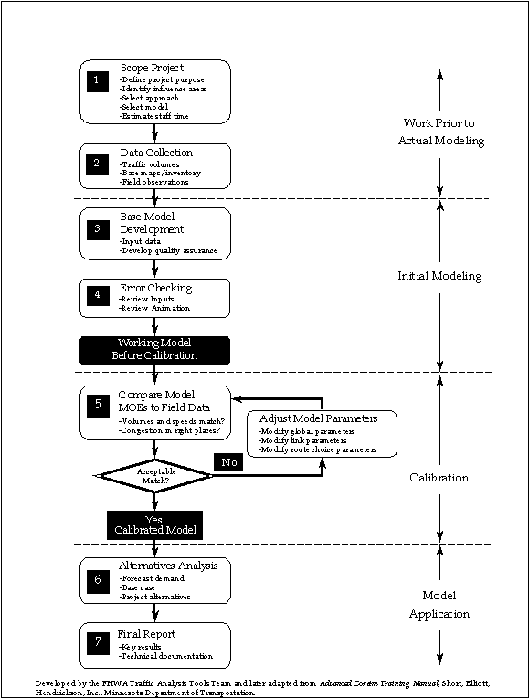
This section provides practical guidelines for modeling the effects of adverse weather on a roadway network using CORSIM. The guidelines presented here are based on Traffic Analysis Toolbox Volume III—Guidelines for Applying Traffic Microsimulation Modeling Software, an FHWA guidance document on the development and application of microsimulation models.(1) Figure 13 shows the seven-step process recommended in the guidelines for developing a microsimulation model and how to apply the model to analyze various alternatives.
Even though the process shown in figure 13 was not designed specifically for modeling weather events, a traffic analyst intent on modeling weather effects should not forget the importance of scoping the project, collecting field data, developing the base model, checking the model for errors, calibrating the model to local conditions, analyzing alternatives, and producing a final report.
Figure 13 lays the foundation for developing and applying an accurate and valid CORSIM model. The same basic steps shown in this figure should be followed even when including the impacts of adverse weather. However, there are a few steps in the process that a traffic analyst should approach slightly differently when modeling adverse weather in CORSIM. These differences are highlighted in the remainder of this section.
It is important to define the project scope in any application of a microsimulation model. However, when using the model to include the effects of adverse weather, a few additional considerations are necessary, including:
Does the selected microsimulation software package have an adequate number of weather-related parameters (see tables 2 through 6) that can be adjusted appropriately to model the weather impacts accurately?
What type of weather event(s) will be modeled (e.g., snow, rain, fog, sun glare, or some combination)?
What is the severity of the weather event(s) being modeled (e.g., 50 millimeters or 1 meter of snow)?
What is the duration of the weather event(s) being modeled (e.g., will it last the entire simulation period, or just for a short period)?
What is the extent of the weather event(s) being modeled (e.g., will it cover the entire simulation model area, or just a portion)?
These are important questions that should be answered and agreed on by all parties involved with developing and reviewing the model before beginning the actual model coding. The first question listed may be the most important of the entire project, because it determines whether the selected software package is able to include the effects of adverse weather successfully. The previous sections of this report have shown that CORSIM can be applied successfully to model weather events and generally does have adequate parameters to account for most weather events.
Collecting actual roadway conditions in the field is important in any application of a microsimulation model. Typical data collected includes traffic volumes, roadway geometrics, signal timing data, transit and pedestrian data, and calibration data (or MOEs) such as capacities, travel times, intersection delays, and queue lengths. When modeling the effects of adverse weather, it is important to attempt to collect data during the weather events being modeled. For example, if the capacity and delay at an intersection is collected during heavy rain, those values obtained can be used to better calibrate a model taking into account heavy rain.
In addition to calibration data (MOEs), traffic parameter data (inputs to the traffic model) also are important to collect in the field during the weather events being modeled. Key weather-impacted traffic parameters identified both in this sensitivity study and the literature review include free-flow speed, car following sensitivity multiplier, discharge (saturation) headway, startup delay, and traffic demand.
Collecting these data in the field and using them as inputs to the microsimulation model will provide a more accurate starting point when going through the calibration process (step 5 in figure 13).
It is recognized that resources and budgets often make it difficult to perform an exhaustive data collection effort for ideal weather conditions, let alone for adverse weather. However, it also should be recognized that the quality of data collection is proportional to the overall quality of the microsimulation model. Therefore, if including the impacts of adverse weather is important to the project, then serious consideration should be given to some form of data collection during the weather event(s) being modeled.
In light of this, if field data collection during the weather event(s) being modeled is not possible or practical, then traffic analysts could use the findings of past research (see section 3) as a starting point when altering traffic parameters to more accurately reflect weather events.
This step includes the initial setup and coding of the microsimulation model and inputting the data collected in the field into the model. When including a weather event in the model, the following additional steps are necessary during the base model development:
Field data collection.
Findings of past research.
Engineering judgment.
For the first step, table 42 can be used to determine which CORSIM parameters are affected by weather events. This table was developed by matching the generic traffic parameters identified in tables 3 through 7 in section 4 of this report to specific CORSIM parameters. To use the table, a traffic analyst must first determine how the weather event being modeled impacts the roadway environment. Figure 2 of this report (section 2) displays which weather events impact the roadway environment.
As an example, suppose a traffic analyst wants to use CORSIM to model the effects of a heavy snowstorm (say four inches in an hour) on a local roadway network. From figure 2, it can be seen that a snow event (especially a heavy snowstorm) will likely cause a reduction in driver visibility and pavement friction, and the storm could block lanes or cover signs and pavement markings. The traffic analyst would make the final determination whether the modeled snowstorm should include blocked lanes and covered signs and pavement markings. Based on these roadway environment impacts, the traffic analyst would then use table 42 to determine specific parameters in CORSIM that may need to be altered due to the snowstorm.
Table 42. CORSIM Parameters Impacted by Weather Events.
| Generic Traffic Parameter | Roadway Environment Impact | CORSIM Parameter(s) | Details |
|---|---|---|---|
| ROAD GEOMETRY PARAMETERS | |||
| Pavement condition |
Reduced pavement friction |
Pavement condition |
Available in FRESIM (freeways) only. Parameter creates an upper bound for the mean free-flow speed.* |
| Number of lanes |
Blocked lanes |
Number of lanes |
Can reduce the number of lanes based on the weather event. |
| Lane width |
Blocked lanes |
Lane width |
Available in NETSIM only. Only changes the graphical display and not traffic operations. |
| Lane taper length |
Blocked lanes |
None |
No parameter for length or type of taper, but can reduce the length of deceleration/ acceleration lanes (in FRESIM) themselves as surrogate. |
| Shoulder width |
Blocked lanes |
None |
No parameter for shoulder width in FRESIM or NETSIM. |
| TRAFFIC CONTROL AND MANAGEMENT PARAMETERS | |||
| Traffic signal/ ramp meter |
Reduced visibility |
Forward sight distance |
No parameter to reduce the visibility of a signal/meter itself. Forward sight distance parameter specifies sight distance from a stop line at a NETSIM intersection. |
| Failed traffic control devices |
Traffic signal/ ramp meter properties |
Can change the control to all-way or two-way stop to simulate flash or blackout conditions. For ramp meter, can turn off the meter for specific time periods. |
|
| Roadway signs (regulatory, warning, traveler information) |
Reduced visibility |
Anticipatory lane change distance, off-ramp reaction point |
No parameter specifically for reducing the visibility of a sign itself. Can change the anticipatory lane change distance and off-ramp reaction point as surrogates to seeing exit signs on freeways. |
| Surveillance detectors |
Failed communications |
Detector properties |
Can delete detectors to simulate failed detector communications. |
| On-street parking |
Blocked lanes |
Curb parking |
Can disallow on-street parking for specific time periods. |
| VEHICLE PERFORMANCE PARAMETERS | |||
| Acceleration / deceleration capability |
Reduced friction/stability |
Acceleration tables |
Can change acceleration tables, including maximum acceleration, using record type 173 of the CORSIM input file. |
| Turning radius |
Reduced friction/stability |
Minimum drawn radius of curvature |
Only changes the graphical display and not traffic operations. |
| TRAFFIC DEMAND PARAMETERS | |||
| Vehicle demand |
All** |
Entry volume and turning volume |
Entry volumes for each entering link can be adjusted as appropriate, and turning volumes can be adjusted depending on the weather event. |
| Route choice |
All** |
Traffic assignment properties |
Available in NETSIM only. Cannot change impedances for individual links to simulate weather events. |
| DRIVER BEHAVIOR PARAMETERS | |||
| Car following |
All** |
See tables 11 and 18 |
See table 35 for key parameters. |
| Lane changing |
All** |
See tables 12 and 19 |
See table 35 for key parameters. |
| Free-flow speed |
All** |
Mean free-flow speed and multipliers |
Mean free-flow speed on all affected links should be changed according to the weather event. |
| Discharge headway |
All** |
Mean discharge headway and multipliers |
Mean discharge headway (at signalized intersections) should be changed according to the weather event. |
| Startup delay |
All** |
Mean startup delay and multipliers |
Mean startup delay (at signalized intersections) should be changed according to the weather event. |
| Intersection gap acceptance |
All** |
Acceptable gap in oncoming traffic (AGOT), cross-street traffic acceptable gap (CSTAG) |
Change AGOT for turns at a traffic signal (permitted left turns and right turns on red) and CSTAG for movements at stop signs. |
| Turning speed |
All** |
Maximum allowable left- and right-turn speed |
Can change maximum left- and/or right-turn speeds in NETSIM. |
| Response to yellow interval |
All** |
Amber interval response |
Defines the acceptable deceleration for a vehicle to stop at a traffic signal. |
After the weather-impacted CORSIM parameters are selected from table 42, then the proper value for them must be determined. As mentioned previously, determining the appropriate values ideally should be done through field data collection. Given that this is often not possible and/or practical for some parameters, the correct parameter values could be estimated through the findings of past research. See section 3 of this report for a review of relevant past research. It is important to use only past research that was collected on roadway facilities, congestion levels, and other field characteristics similar to those being modeled. Finally, in the absence of field data collection and past research, engineering judgment can be used to estimate the correct parameter values. For example, it is difficult to collect lane changing parameter data in the field, and there are no past studies regarding lane changing behavior in adverse weather. Thus, in this case, changing the lane changing parameters to represent slightly more conservative driver behavior (as would likely happen in adverse weather) would probably be a reasonable choice based on engineering judgment.
While table 42 shows the range of traffic parameters impacted by weather events, it may not be possible or practical to change all of the impacted parameters for various reasons. With these limitations in mind, a handful of key traffic parameters have been identified, based on past research and the sensitivity study summarized in this report, to be the most important weather-impacted parameters in terms of their impact on MOEs. Even when resources and budgets are tight, these CORSIM parameters at a minimum should be altered to appropriate values when modeling weather events:
Mean free-flow speed (freeways and arterials).
Car following sensitivity multiplier (freeways).
Mean discharge headway (signalized intersections).
Mean startup delay (signalized intersections).
Traffic demand, in terms of reduced demand during more severe weather events (freeways and arterials).
Model calibration is an iterative process where the model parameters are altered until the model results (MOEs) adequately match the field-measured MOEs. Calibration is needed, because the default parameter values often do not result in model MOEs close to those measured in the field. This is especially true when including a weather event in the model, because all microsimulation software packages assume ideal weather conditions in the default values.
Even after adjusting the weather-impacted parameters to appropriate values as described in the previous section, calibration is likely still needed to ensure the best model parameters are used. The Traffic Analysis Toolbox Volume III—Guidelines for Applying Traffic Microsimulation Modeling Software recommends a three-step calibration strategy:(1)
For each step, calibrating the global parameters (parameters that affect the entire microsimulation model) should be done first, while fine-tuning link-specific parameters as necessary should follow.
The key weather-related parameters as identified in the previous section are also the key parameters used to calibrate any CORSIM model, regardless if a weather event is being modeled. Thus, the process for calibrating a model that includes a weather event is not really different than calibrating a generic CORSIM model. Refer to the simulation guidelines for more detail on the calibration process.(1)
This section highlights the need to measure MOEs in the field, because there would be no basis to calibrate to if field MOEs were not measured. When including a weather event in the microsimulation model, the best way to calibrate such a model would be to collect field MOEs during the weather event being modeled. However, as stated previously, this can be difficult.
If field MOEs are not collected during the modeled weather event, then a secondary method for calibrating the weather-related model is possible. In this method, the first step is to calibrate the model during ideal weather conditions. This includes coding the microsimulation model for ideal weather and then calibrating the model to field MOEs collected during ideal weather. After developing a calibrated ideal weather model, then only the weather-related parameters would be adjusted to account for the adverse weather. The weather-related parameters would be adjusted based on the discussion in the previous section (i.e., adjustments based on field data, then past research, and finally, engineering judgment). While such an approach would not produce a model specifically calibrated to the weather event, it would at least produce a reasonably adequate adverse-weather model, because it was already calibrated to ideal weather, and only a few parameters were adjusted thereafter.