U.S. Department of Transportation
Federal Highway Administration
1200 New Jersey Avenue, SE
Washington, DC 20590
202-366-4000
Federal Highway Administration Research and Technology
Coordinating, Developing, and Delivering Highway Transportation Innovations
 |
| This fact sheet is an archived publication and may contain dated technical, contact, and link information |
|
Publication Number: FHWA-HRT-05-055
Date: March 2005 |
Transportation Asset Management System for Roadway Safety: Idaho's Guardrail Management System Saves Lives, Time, and MoneyPDF Version (200 KB)
PDF files can be viewed with the Acrobat® Reader® New High Tech/Low Cost Guardrail Inventory System Helps Idaho Transportation Department Meet Safety and Maintenance GoalsThe Idaho Transportation Department (ITD) developed and maintained, with some success, inventories of their roadway assets such as bridges, pavements, guardrails, and signs. However, regularly updating these inventories was challenging and labor intensive. The Federal Highway Administration's (FHWA) continuing emphasis on eliminating blunt ends and other obsolete road safety hardware further underscored ITD's need for a more complete and accurate database of roadside amenities. To assist with verifying and upgrading the highway guardrail inventory, ITD has implemented a new video logging system using state-of-the-art digital photo imaging data. The application not only improves accuracy, it also significantly reduces the resources needed to maintain the data. By providing good information about guardrails, the "GRail" system allows managers to effectively address locations where damaged or obsolete guardrails may compromise the safety of highway travelers. The inventory includes all of Idaho's Interstate and National Highway System routes.
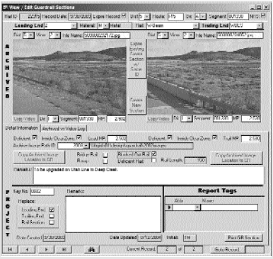
Figure 1. GRail-Guardrail inventory detail. What is it?The GRail application was developed by ITD staff using Microsoft® Access Visual Basic®. The system serves as an interface between the photo log data sources and the guardrail inventory database. The current inventory is a compilation of the original 1995 inventory, District updates, and a review of the 2002 and 2003 photo logs. There are approximately 5,400 guardrail sections in the inventory. The process involves comparing the existing guardrail inventory to the latest photo log and updating information where the photo log shows a changed condition. New guardrail installations are entered manually from project plans. A photo album of deficient guardrail (questionable sections or sections targeted for upgrade) is prepared for review and correction by the appropriate District Office. Updates received by ITD headquarters are entered into the database. The application, tables, and archived photos require approximately 500 MB of hard drive space to store the database.
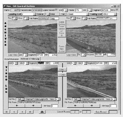
Figure 2. GRail-Guardrail inventory photo log entry. How does it work?The state-of-the-art roadway video logging survey system is set up in a vehicle with equipment capable of collecting high quality images, Global Positioning System (GPS) location data, and distance traveled for use in the GRail system. The vehicle contains fully computerized control features allowing the driver and the operator to collect data on hundreds of lane miles per day in a comfortable environment at normal highway speeds. Using the distance and sensor data collected, location fields, such as milepost, distance and offset, road name, direction, latitude, and longitude are automatically filled in by the system. In addition to the GRail information, the vehicle collects digital images and curvature data that are used for traffic applications and the GPS latitude and longitude data for mapping and interfacing with ITD Geographic Information System (GIS) systems. Image and data files from these surveys are downloaded to file servers located in each ITD District Office. The GRail program accesses this data over the department's Wide Area Network.
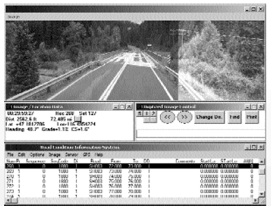
Figure 3. Video log software. ITD is in the process of implementing an enterprise-wide data system that connects all ITD business functions with available information. Roadside features including guardrail, signs, sign structures, culverts, railroad crossings, bridges, and approaches are electronically connected to work orders, financial information, capital planning, and other related information as part of this ITD-wide solution to manage their assets. Including GRail in the enterprise system will permit managers to quickly and accurately assess guardrail conditions and determine funding needed for upgrades and replacements. For More InformationFor a copy of Idaho's full report on this topic, or more information, contact: Ted Mason Geometrics Engineer Roadway Design Section Idaho Transportation Department P.O. Box 7129 Boise, ID 83707-1129 Phone: 208-334-8500 Fax: 208-334-8025 Email: tmason@itd.idaho.gov Rick Scarr Safety/Bridge Engineer FHWA - Idaho Division 3050 Lakeharbor Lane Ste. 126 Boise, ID 83703 Phone: 208-334-1843 Fax: 208-334-1691 Email: Idaho.FHWA@fhwa.dot.gov Roadway safety hardware management systems vary in scope, integration, and elements managed. States have approached asset management differently, but all aim to improve resource utilization, decisionmaking processes, safety, and system reliability. For more information on nationwide transportation asset management for roadway safety systems and State departments of transportation contacts, please contact: Kerry Perrillo Highway Research Engineer Federal Highway Administration 6300 Georgetown Pike McLean, VA 22101 Phone: 202-493-3318 Email: kerry.perrillo@fhwa.dot.gov Supported by the FHWA Offices of Safety, Asset Management and Safety Research, Development and Technology |