U.S. Department of Transportation
Federal Highway Administration
1200 New Jersey Avenue, SE
Washington, DC 20590
202-366-4000
Federal Highway Administration Research and Technology
Coordinating, Developing, and Delivering Highway Transportation Innovations
 |
| This techbrief is an archived publication and may contain dated technical, contact, and link information |
|
Publication Number: FHWA-HRT-09-062
|
Simulator Evaluation of Low-Cost Safety Improvements on Rural Two-Lane Undivided Roads: Nighttime Delineation for Curves and Traffic Calming for Small TownsFHWA Contact: Roya Amjadi, PDF Version (541 KB)
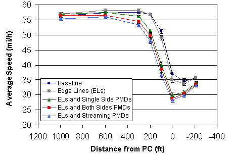
PDF files can be viewed with the Acrobat® Reader® This document is a technical summary of the Federal Highway Administration report, Simulator Evaluation of Low-Cost Safety Improvements on Rural Two-Lane Undivided Roads: Nighttime Delineation for Curves and Traffic Calming for Small Towns, FHWA-HRT-09-061. ObjectiveThe Federal Highway Administration (FHWA) organized 26 States to participate in the FHWA Low Cost Safety Improvements Pooled Fund Study as part of its strategic highway safety plan support effort. The purpose of the pooled fund study is to estimate the safety effectiveness for several of the unproven low-cost safety strategies identified in the National Cooperative Highway Research Program (NCHRP) Report 500 Series.(1) One of the strategies chosen to be evaluated for this study is improved curve delineation, which is intended to reduce the frequency of curve-related crashes by providing more conspicuous signing and lane markings. In this study, a driving simulator experiment was conducted to evaluate two sets of alternative low-cost safety improvements for rural areas based on Technical Advisory Committee recommendations from the 2007 Annual Meeting. The first set of improvements was directed toward enhancing the visibility of curves on rural two-lane undivided roads at night. It focused on achieving advanced detection and speed reduction in such curves. The second set of improvements was directed toward slowing traffic on rural two-lane undivided roads in small towns during the day by focusing on traffic calming within the towns. IntroductionTreatments for CurvesPart of this study investigated low-cost visibility enhancements for navigating rural horizontal curves at night. According to the Fatality Analysis Reporting System, of the 37,248 fatal crashes in 2007, 6,495 (17.4 percent) were on horizontal curve sections of two-lane rural roads.(2) Of those, 2,739 crashes (42.2 percent) occurred at night. Previous data have indicated that approximately 25 percent of all vehicle miles traveled (VMT) occur at night. Rural local roads may have less than 25 percent of VMT occurring at night. Even if the total VMT is adjusted for the more conservative total, the exposure rate is more than twice as high during the night compared to the day. Thus, fatal crashes on rural curves at night represent an important crash category, and improving the visibility of rural curves at night has been shown to reduce this type of crash.(3) To help enhance the visibility of curves, edge lines and post-mounted delineators (PMDs) were selected as the best alternatives for the simulator study. A synthesis of research has shown that introducing and enhancing edge lines has a wide range of results, from decreasing vehicle speeds by 3.1 mi/h (4.9 km/h) to increasing vehicle speeds by 6.6 mi/h (10.6 km/h).(4) Although the overall effect of combining the results of multiple studies was not statistically different from zero, individual experiments showed results different from zero. In terms of driver preview distances for curves driven at night, Molino et al. calculated anywhere from a 12- to 70-percent improvement in curve detection distances due to enhanced edge lines.(5) PMDs have also been found to reduce crash rates on relatively sharp curves during the night. Agent and Creasey performed field and laboratory investigations which indicated that PMDs had a beneficial effect; however, pavement markings had an even greater beneficial effect based on vehicle speed and lane encroachment.(6) Meanwhile, Montella evaluated the safety effectiveness of various horizontal curve delineation treatments in Italy.(7) A novel treatment using sequential flashing beacons was part of this evaluation. When sequential flashing beacons were added to chevrons and curve warning signs, the reported number of crashes decreased by 77 percent compared to the expected number using an Empirical Bayes analysis. Treatments for TownsIn 2003, 86 percent of speeding-related fatalities occurred on roads that were not interstate highways, and the highest speeding-related fatality rates occurred on local and collector roads where the lowest speed limits were posted, suggesting that research should be conducted to identify and promote engineering measures to better manage speed.(8) In addition, research should be performed to achieve appropriate speeds on main roads through towns that are not suitable for traditional traffic calming techniques. This simulator study investigated the speed calming effects of chicanes located at the beginning and end of a town. There are several resources available regarding the design of chicanes, but their effectiveness has not been determined with rigorous research. Traffic Calming: State of the Practice refers to an installation of chicanes and speed tables in Montgomery County, MD, where speeds decreased from 34 to 30 mi/h (54.7 to 48.3 km/h), and volume decreased from 1,500 to 1,390 vehicles per day.(9) Marek and Walgren found that chicanes were effective at reducing 85th-percentile speeds at four different locations in Seattle, WA, with reductions between 5 and 13 mi/h (8.05 and 20.93 km/h) inside the chicane area and 1 and 6 mi/h (1.61 and 9.7 km/h) outside the chicane area (after the chicane has been passed).(10) Additionally, bulb-outs were evaluated at intersection locations in a town for this study. Bulb-outs are curb extensions that are designed to slow drivers down. King analyzed the effect of bulb-outs in New York City, NY, and found that at four of six surveyed locations, the overall severity rates for crashes were reduced after bulb-outs were installed.(11) Furthermore, at two of three locations, the injury severity rates were also reduced. Huang and Cynecki performed an analysis at two locations in both Cambridge, MA, and Seattle, WA, to determine whether drivers would yield to pedestrians with the addition of bulb-out treatments.(12) The results for Cambridge were inconclusive. In Seattle, there was no change in vehicle yielding behavior. METHODOLOGYParticipantsParticipants were licensed drivers between the ages of 18 and 88 with a mean age of 57.6. Of the 36 participants who completed the experiment, half were under the age of 65 (the age range was 18–64 with a mean age of 41.7), and half were above the age of 65 (the age range was 66–88 with a mean age of 73.6). Each age group (younger and older) was evenly distributed between males and females. Although the sample of participants was balanced for age and gender, these factors were not analyzed in the experiment. Driving SimulatorFHWA's Highway Driving Simulator (HDS) is a relatively high-fidelity research simulator. Simulator components include a 1998 Saturn SL1 automobile chassis, five projectors, and a cylindrical projector screen with 240 degrees of forward view. Under the vehicle chassis, there is a 3 degree-of-freedom motion system. A sound system provided engine, wind, tire, and other sounds. A microphone was used to record the verbal responses made by the participants. Experimental SessionsEach participant received all treatment conditions. In addition, each curve or town was separated by a long tangent segment of roadway. The drives consisted of 26 trials, 20 curves, and 6 towns in a quasi-random order all separated by a tangent. The participants completed three such drives. The simulated driving condition instantly changed to night for curves and to day for towns. Simulated Treatments for CurvesAll of the curves and their preceding tangents consisted of two-lane rural roadways. Participants drove through the curves at night with no fixed roadway lighting. There was no traffic on the roadway in either direction because the glare from oncoming headlights was more difficult to simulate. Therefore, it was decided to employ basic driving conditions without any traffic. The rural tangent and curve roadway segments had lane widths of 11 ft (3.4 m) with 3-ft (0.9-m) paved shoulders on either side. The radius of curvature was either 100 ft (30.5 m) for the sharp curves or 300 ft (91.5 m) for the less sharp curves. The deflection angle was 60 degrees for both types of curves. The term gentle was used to distinguish the less sharp curves for the research participants. There were an equal number of right-hand and left-hand curves. The simulator could reproduce the effects of superelevation only to a certain degree, so it was decided not to employ it. There were no curve warning signs preceding the curves. Advance warning signs were not employed so as to measure the effects of the pavement markings and the PMDs themselves to enhance driver detection of curves ahead. At the beginning of half of the tangent sections, there was a speed limit sign indicating 55 mi/h (88.5 km/h). For the curves, the baseline condition consisted of standard 4-inch (101.6-mm)-wide double yellow centerlines on the roadway, both on the preceding tangent and on the curve itself. The first level of low-cost safety improvement beyond the centerlines was the addition of a conventional 4-inch (101.6-mm) white edge line to both sides of the roadway on the preceding tangent as well as on the curve. The next level of improvement involved the application of various configurations of reflectorized PMDs as an addition to the white edge lines and yellow centerlines. The first PMD configuration was the standard installation of delineators on the far side of each curve. The second PMD configuration employed the same standard layout of delineators except on both sides of the roadway. The third configuration employed similarly spaced PMDs with simulated light-emitting diode (LED) lamps at the top of each post (above the standard reflector panel). These enhanced delineators were located on the far side of each curve. The LED lamps were programmed to create a repetitive streaming light pattern moving in the direction of the curve. The LED lights streamed faster for sharp curves and slower for gentle curves. The repetition rate of the streaming light patterns was 3 Hz for sharp curves and 1 Hz for gentle curves. Thus, the LED-enhanced delineators provided information on both the direction and the severity of approaching curves. These streaming lights operated continuously. The edge lines were always present with the addition of any of the PMD conditions, reflecting common implementation practice. Each experimental drive contained 20 curve conditions in a different order (5 treatments for 4 types of curves). Responses to CurvesParticipants were instructed to verbally indicate the direction and severity of each approaching curve as soon as they were confident that they could identify the particular roadway feature. Participants were instructed to say "right" or "left" as soon as they could predict the direction of the curve and "sharp" or "gentle" as soon as they could predict the curve's severity. The time of their verbal responses was recorded and converted into distance from the point of curvature (PC) of the curve. The participants were instructed to drive at 55 mi/h (88.5 km/h) in all preceding tangent sections of the roadway. Otherwise, they were instructed to drive as they normally would. Simulated Treatments for TownsFor the town portion of the experiment, a single small town was simulated, and it was approached an equal number of times from each direction. The town was always presented in simulated daylight, and it consisted of a main two-lane roadway with marked parking spaces on each side. Each town segment was about 450 ft (137.3 m) long, and it was preceded and followed by a long rural tangent. There was no traffic on the roadway in either direction. In addition, there were no pedestrians or speed limit signs leading up to or in the town. The baseline condition consisted of standard 4-inch (101.6-mm)-wide double yellow centerlines on the roadway—both on the preceding tangent and in the town itself. The first low-cost safety improvement beyond the centerlines was the addition of bulb-outs at all intersections in the town. These bulb-outs were simulated as curb and gutter modifications. In addition, a less expensive bulb-out configuration was implemented by means of pavement markings alone. Each travel lane was 11 ft (3.4 m) wide in the bulb-outs. By way of contrast to the baseline condition, an additional condition was investigated with cars parked in most of the marked parking spaces on both sides of the main road. The next low-cost safety improvement consisted of chicanes at the entrance and exit of the town. These chicanes were first implemented in the standard manner by means of curb and gutter modifications. The chicanes were also implemented by means of pavement markings only. For the chicanes, the minimum radius of curvature was approximately 325 ft (99.1 m), and the shifts were sufficiently gradual over a total distance of 88 ft (26.8 m) to maintain speeds of approximately 20 mi/h (32.2 km/h). These gradual shifts were also designed to minimize truck off-tracking and to facilitate emergency vehicle use. Each experimental drive contained one of the six conditions in a different order, with three approaches from each direction. RESULTSSpeed Profiles for CurvesFigure 1 shows the average driving speed as a function of distance from the PC for the five curve treatment conditions as well as for the baseline condition. The data in figure 1 represent speed profiles in terms of average speeds across the 36 research participants, 4 curve geometries, and 3 drives. The error bars represent 1 standard error of the mean. The speed profiles indicate a constant portion in the far tangent, then a rapid deceleration, followed by a shallow dip. The treatments tended to organize themselves into two groups: (1) pavement markings (baseline and edge lines) and (2) delineators (single side PMDs, both sides PMDs, and streaming PMDs). This treatment effect was statistically significant (F (4, 32) = 51.7, p < 0.001). The delineators were more effective than the pavement markings in slowing the drivers down sooner and to a greater degree. For distances of under 600 ft (183 m), the consistent treatment effect was evident over the entire range of locations without any order reversals.
Figure 1. Graph. Average speed as a function of the distance from the PC. Speed Reduction and Feature Detection for CurvesTable 1 summarizes the potential safety advantages in terms of speed reduction and feature detection distance for the curves. Based on speed measurements at the point of curvature, column 2 shows the estimated average speed reductions for the various curve visibility improvements (relative to the baseline, rounded to the nearest 1 mi/h (1.6 km/h)), and column 5 shows the corresponding speed reduction rankings for each (from best to worst). Table 1 . Estimated safety advantages and rank ordering of treatments for curves.
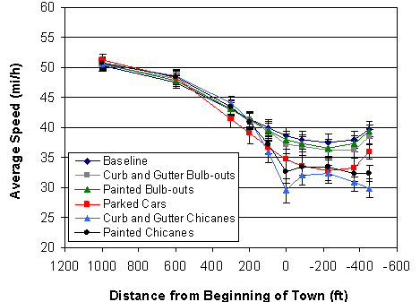
Drivers performed almost perfectly in detecting the direction of curves ahead in the road (99.7 percent correct). In table 1, column 3 shows the estimated average curve direction detection distance increases for each treatment (relative to the baseline, rounded to the nearest 5 ft (1.5 m)), and column 6 shows the corresponding detection distance rankings for each. Compared to curve direction detection, drivers did not perform as well on curve severity detection (only 82.5 percent correct). While this performance was better than chance, drivers had more difficulty detecting the severity of a curve than detecting its direction. Column 4 shows the estimated average curve severity detection distance increases for each treatment, and column 7 shows the corresponding severity detection rankings for each treatment. A comparison of findings across the three response categories in table 1 reveals two important relationships. First, if the standard reflectorized PMD conditions are collapsed (single versus both sides), there is a consistent order across all three response categories (speed plus direction and severity distances). The enhanced PMDs with streaming lights performed the best followed by the standard reflectorized PMDs, and the edge lines performed the weakest or showed no improvement. Second, the enhanced PMDs with streaming lights performed exceptionally well in terms of increasing curve feature detection but only moderately well in terms of slowing drivers down. Speed Profiles for TownsFigure 2 shows the average vehicle speed as a function of distance from the beginning of the town for the six different town treatment conditions. The data in figure 2 represent speed profiles in terms of averages for the 36 research participants over the 3 drives. The error bars represent 1 standard error of the mean. Positive distances indicate measurement locations ahead of the town, and negative distances indicate locations in the town.
Figure 2. Graph. Average speed as a function of the distance from the beginning of the town. The speed profiles in figure 2 indicate a gentle deceleration followed by a plateau. The treatments were organized into three groups: (1) baseline and bulb-outs (baseline, curb and gutter bulb-outs, and painted bulb-outs), (2) parked cars, and (3) chicanes (curb and gutter chicanes and painted chicanes). This treatment effect was statistically significant (F (5, 30) = 12.5, p < 0.001). The shapes of the speed profile functions were similar for all of the five types of safety countermeasures except the chicanes. For all other countermeasures, the minimum speed was achieved near the middle of the town or slightly further into the town. For the chicanes, the minimum speed was achieved at the beginning and end of the town where the chicanes were located. In the town itself, the speed increased for the chicane conditions, reaching a local maximum at the middle of the town and decreasing again for the second chicane. Speed Reduction for TownsThe major findings regarding the relative advantages of the various speed calming treatments for small towns are summarized in table 2. For both locations at the beginning and middle of the town, table 2 shows estimated average speed reductions (relative to the baseline condition) of the tested safety improvements as well as their rank ordering (from best to worst). Both types of bulb-outs produced either a very small reduction in speed or did not show improvements from the baseline. In general, chicanes produced the greatest reduction in speed. Table 2 . Estimated speed reductions and rank ordering of treatments for towns.
SUMMARYPotential Safety Benefits for CurvesFor curves, the results of the experiment indicated that edge lines offered a small potential safety benefit. Adding standard reflectorized PMDs used with edge lines offered a somewhat greater benefit. In general, standard reflectorized PMDs with edge lines performed better than pavement markings alone. This result does not imply that edge lines are not needed; edge lines provide continuous delineation of the travel lane, especially at close range. Of all the treatments explored, the streaming PMDs with edge lines offered the most potential safety benefit. Presently, the streaming PMD solution has not been developed for two-lane rural roads, nor are the potential future cost implications of implementing this countermeasure known at this time. Further research is recommended including economic analysis and field validation studies. Potential Safety Benefits for TownsFor towns, the results indicated that bulb-outs offered a small potential safety benefit or no benefit at all. Painted chicanes and parked cars on both sides of the road offered a greater benefit, and curb and gutter chicanes offered the most potential safety benefit. In general, chicanes and parked cars performed the best as traffic calming countermeasures. The painted chicanes and parked cars solution proved to be an effective and low-cost speed-calming measure. However, the above results have not been validated in the field. Simulation of driving through a small town does not take into account all of the hazardous factors involved in actually driving through a town. In addition to concerns about parked cars, especially in cases where there is only one travel lane in each direction, attention needs to be paid to assessing and balancing the possible safety hazards of vehicles, drivers, passengers, and pedestrians entering the roadway. The parked cars solution also raises some potential problems for bicycle traffic. Concerning chicanes, especially in cases without a separating median, attention needs to be given to assessing and balancing the possible safety hazards of head-on or sideswipe opposite-direction crashes. In general, bulb-outs and chicanes should only be implemented in well-lit areas. CONCLUSIONThe present experiment focused on two areas: (1) the advanced detection and speed reduction for curves in rural two-lane roads at night and (2) traffic calming for small rural towns during the day. For curves, PMDs used with edge lines performed better in terms of slowing drivers down than pavement markings alone. The novel streaming PMDs solution offered the most dramatic potential benefit in terms of advanced curve detection, and this solution is worthy of further study. For towns, chicanes slowed drivers down the most followed by parked cars on both sides of the road. Further study and consideration should be given to adding painted chicanes to town entrances and providing for and encouraging parking in towns. References
|