U.S. Department of Transportation
Federal Highway Administration
1200 New Jersey Avenue, SE
Washington, DC 20590
202-366-4000
Federal Highway Administration Research and Technology
Coordinating, Developing, and Delivering Highway Transportation Innovations
 |
| This techbrief is an archived publication and may contain dated technical, contact, and link information |
|
Publication Number: FHWA-RD-99-103
Date: April 1999 |
||||||||||||||||||||||||||||||||||||||||||||||||||||||||
Intersection Collision Warning SystemFHWA Contact: Tim Penney, tim.penney@dot.gov, PDF Version (325 KB)
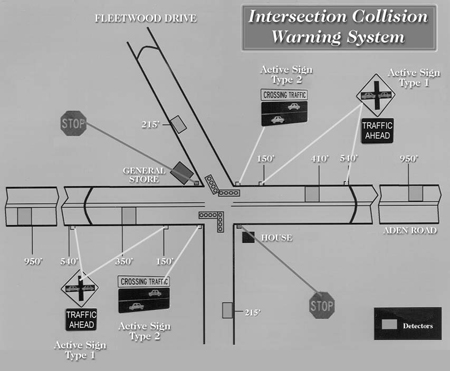
PDF files can be viewed with the Acrobat® Reader® BackgroundSafety at unsignalized intersections is a major concern. Intersection collisions are one of the most common types of crash, and in the United States, they account for nearly 2 million accidents and 6,700 fatalities every year. However, a fully signalized intersection can sometimes be hard to justify in rural areas, due to the cost of installation, maintenance, and added delays to traffic on the major through streets. The Intersection Collision Warning System (ICWS) project studied the effectiveness of an innovative and potentially less expensive approach to improving safety in these situations. This approach consists of two types of traffic-actuated warning signs linked to pavement loops and a traffic signal controller. Project DescriptionThe purpose of the ICWS project was to enhance driver awareness of the traffic situation at the intersection by providing timely and easily understood warnings of vehicles entering the intersection. In other words, drivers approaching the intersection on a major through road are given a warning—a flashing car symbol—when there is a vehicle prepared to enter the intersection from the cross street. At the same time, drivers waiting at the stop signs on the minor approach are given a "crossing traffic" alert—with an animated car symbol—when traffic is approaching along the major approach from either direction. This system is the first of its kind anywhere, and was designed to specifically address the intersection of a major road and a stop sign-controlled cross street. Figure 1 (on the following page) illustrates a plan view of the intersection location where the ICWS was installed.
System CapabilitiesSensors embedded in the pavement detect the presence of vehicles waiting to enter the intersection at the minor approach and measure the speed of approaching vehicles on the major approach. The information is collected by a computer controller at the intersection that estimates the various vehicles' arrival times and activates the warning signs accordingly. Evaluation ApproachThe field study was comprised of a three-phase ("before," "acclimation," and "after") ICWS evaluation based on observed vehicle behaviors immediately before, immediately after, and 4 months following ICWS installation. Results reported herein are based on a 42-day data sample, comprising approximately 97,000 vehicles traversing the intersection. However, due to the necessity of basing ICWS evaluation results on the affected driver sample (e.g., two competing motorists approaching the intersection at the same time), results were based on a targeted sample comprised of 1,652 vehicles. Measures of Effectiveness (MOEs) were derived from ICWS operational objectives, specifically addressing vehicle behaviors that the ICWS intends to affect. The analysis applied the MOEs to rural intersection accident-avoidance requirements. Applied MOEs were: (1) drivers' ICWS speed responses in the presence of cross traffic; (2) intersection approach speed reductions; and (3) projected times to collision (PTCs), i.e., the elapsed time to which an approaching vehicle would collide with a vehicle in path in the absence of timely avoidance response. Human factors (e.g., driver perception-reaction time) accident-avoidance requirements determined critical PTC values that were used in the analysis. ResultsThe data analysis demonstrated that the ICWS had a greater impact on driver behavior on the approach with the shorter sight distance. Specific findings were as follows:
Measures of Effectiveness
Table 1. "Before" versus "after" period MOE differences
* = Significant difference, <0.01 For More InformationThe project was funded by the Federal Highway Administration and conducted by Raytheon Systems Company of Falls Church, Virginia, in cooperation with the Virginia Department of Transportation and Prince William County, Virginia. For more information, please contact Tim Penney, Office of Safety Research and Development, (703) 285-2174. The national Intelligent Transportation Systems (ITS) program includes the development and application of advanced systems upon all parts of the transportation network, including rural areas. The U.S. DOT has developed the Advanced Rural Transportation Systems (ARTS) program to meet the needs of travelers in and through rural areas, as well as the agencies responsible for the operation and maintenance of the rural transportation system. The ARTS program complements the ITS efforts in metropolitan areas and commerical vehicle operations (CVO) by studying ways to best implement technologies that address transportation problems in rural areas. |
||||||||||||||||||||||||||||||||||||||||||||||||||||||||