U.S. Department of Transportation
Federal Highway Administration
1200 New Jersey Avenue, SE
Washington, DC 20590
202-366-4000
Federal Highway Administration Research and Technology
Coordinating, Developing, and Delivering Highway Transportation Innovations
|
Research & Technology Transporter This newsletter is an archived publication and may contain dated technical, contact, and link information. |
|
| Publication Number: N/A Date: August/September 2002 |
Publication Date: August/September 2002
|
Maine's extensive use of bark mulch for landscaping and roadside erosion control was just one of the many low-tech practices that caught the attention of Russia's Peter Orlov, the vice governor of the Arkhangelsk Oblast (the Russian equivalent to a U.S. State) and Evgeniy Lobanov, the director of the Arkhangelsk Road Administration's Construction Group during a visit to the United States last summer.
Why bark mulch? Maine and Arkhangelsk both have large forestry industries. Russian standard practice was to truck wood by-products and non-composted materials off to nearby dumps where they took up valuable landfill space. Maine's much more economical and environmentally friendly alternative, using this recycled by-product for slope stabilization, erosion control, and roadside beautification, led to what might be called a "Eureka" moment for the Russians.
Lobanov explored every aspect of bark mulch and composting from manufacturing to application equipment and their multiple uses. He was particularly impressed with a "biomat" made from bark mulch and compost, because slope stabilization has been a challenge for the Arkhangelsk Road Administration.
Bark mulch and compost were among several findings Lobanov documented in a 31-page report he drafted after returning from a 6-week internship with his counterparts in the Maine Department of Transportation. In his report, Lobanov wrote, "Bark mulch can be used for temporary or permanent erosion control, even when the ground is frozen."
 |
| Evgeniy Lobanov holds a handful of freshly ground mulch while visiting a mulch manufacturing site in Maine. |
The next step in the partnership between Maine and Arkhangelsk for technology transfer included a month-long U.S. visit for two Arkhangelsk engineers, Angelina Ignateva and Natalia Stoika. The technology exchange was mutually beneficial, as Ignateva and Stoika shared information about Russian environmental practices and concerns with their U.S. counterparts. Among the topics for discussion were Russia's strict standards prohibiting river and stream dumping of snow cleared from bridges and requirements for building roads farther from water bodies to protect them from nonpoint source pollution.
FHWA officials in the Office of International Programs are translating Lobanov's report into English. Once completed, the translated report will be available at http://international.fhwa.dot.gov.
For more information, contact:
Tracy Busch
For years, State and local highway engineers have recognized the value of hot-mix asphalt (HMA) pavement recycling on low-volume roads and local streets. By recycling old pavements in place, agencies can stretch their project dollars by reducing raw material and shipping costs. Another benefit of pavement recycling is that it often helps construction projects move along more efficiently, getting people back on the roads faster. Increasingly, new recycling agents and equipment tailored for in-place pavement rehabilitation are making HMA recycling a viable option for high-volume roads and larger highway projects.
To bring State and local highway engineers up to speed on these new technologies, the Federal Highway Administration (FHWA) and the Asphalt Recycling & Reclaiming Association (ARRA) recently sponsored an updated pilot for the National Highway Institute's (NHI) course on HMA recycling technology.
More than 25 New Mexico State and county highway engineers and FHWA representatives from the Western Resource Center and Division Offices attended the pilot in Albuquerque, NM, in early May 2002. The course's target audience is decisionmakers, chief engineers, designers, and construction engineers. It represents an updated and modernized version using ARRA's Basic Asphalt Recycling Manual as a student reference guide follow-up of NHI's Course #131050, Pavement Recycling for State and Local Governments.
In the revised course, FHWA encourages highway engineers to consider HMA recycling for larger projects, such as those on State highways and other high-volume roads. HMA recycling enables engineers to rehabilitate pavements in-place, using hot in-place methods for pavement surface distress in the first 50 millimeters (2 inches), cold in-place methods for repairing deeper structural distress in a range of 50 to 150 millimeters (2 to 6 inches), or using full depth methods to reconstruct the pavement's structural base.
Course instructors use lectures, practical exercises, and case histories to demonstrate the viability of HMA recycling. During the 2-day course, participants learn about various pavement recycling methods, materials, and equipment and how to determine if HMA recycling is the most appropriate pavement rehabilitation technique for select projects.
Based on input received during the pilot, FHWA further revised the course at the end of June and will start conducting additional courses later this year. For more information, visit the NHI Web site at www.nhi.fhwa.dot.gov
Jason Harrington 202-366-1576 k.jason.harrington@fhwa.dot.gov
Reviewing bridge proposals sometimes poses unusual challenges for designers as they analyze plans to modify or change existing bridges-especially when there are other structures that might affect the final project design. In downtown Milwaukee, WI, engineers wanted to remove the 1.1-kilometer (0.7-mile) elevated freeway stretch just north of the city and construct a new at-grade roadway and bridge. A major challenge to getting the project off the ground lay in assessing the potential danger to an existing 29-meter (96-foot) sanitary sewer line running beneath the Milwaukee River that might be caused by local pier scour for the proposed bridge alignment.
The city of Milwaukee and the Wisconsin Department of Transportation (WisDOT) were planning a $9.7 million Park East Freeway reconfiguration project and wanted to ensure that their plans would not affect the sewer line adversely. To make the evaluations, Federal Highway Administration (FHWA) Wisconsin Division Bridge Engineer Tom Strock worked with researchers in the FHWA Hydraulics Laboratory to resolve some of the issues dealing with potential threats to the sewer line.
Researchers completed flume tests in the Hydraulics Lab to determine if the sewer line would be in danger of exposure or failure under the anticipated scour from the bridge piers. Preliminary tests indicated that the sewer pipe probably was not in danger unless the angle of incline on the piers was severe at more than 15 degrees; however, the sewer line position was a little different in the actual scenario.
Follow-up site investigations revealed that the sewer pipe was 1.8 meters (6 feet) higher than originally assumed but was protected by sheet piles that extended well below the anticipated scour depth. Now, the issue became the structural integrity of the sheet piles, since tests showed that a deep scour hole could develop on one side of the sheet piles.
 |
| A scour test shows a deep scour hole occurring in front of the sheet pile (simulated by the vertical sheets of plywood in the center of the photograph). The concern was that the sheet pile in the foreground might buckle into the scour hole. |
The lab conducted a total of 13 model tests in the flume. The flume tests showed that a rock riprap armor layer along the sewer pipe alignment would arrest the scour in front of the sheet piles. Consultants for WisDOT suggested an extra safety measure by tying the upstream sheet pile to the downstream sheet pile along the top edge to strengthen the system against a cantilever failure.
The improved at-grade roadway and vertical lift bridge will replace the existing current freeway spur, which carries nearly 48,000 vehicles every day. It was just as important to protect the sewer line running beneath the bridge as it was to guarantee driver safety on the bridge.
The Park East Freeway Reconfiguration Project began this summer, and WisDOT officials expect to open the freeway in 2004. The new roadway will not only enhance the safety and efficiency of the Park East Freeway, but it also will open high-value land currently occupied by the freeway for private business development, offering an additional economic benefit to the city of Milwaukee.
For more information about this research study, keep an eye out for the FHWA report, Laboratory Scour Investigation McKinley/Knapp Street Bridge over the Milwaukee River, which will be published later this year.
Sterling Jones
From fog and rain to hurricanes and blizzards, weather threatens transportation mobility, safety, and productivity. The weather not only affects driver performance, but also traffic and emergency routes suddenly with little or no warning. The best-case scenario would be to control the weather; since that is unrealistic, traffic, maintenance, and emergency managers must find other methods to mitigate weather effects.
Mitigation strategies provide information on prevailing or predicted road weather conditions, permit or restrict traffic flow, and supply resources for treating roadways. When timely and accurate road weather information is available, managers can proactively minimize the effects of adverse weather on roadways.
For the last 2 years, researchers in the Road Weather Management program at the Federal Highway Administration (FHWA), with support from Mitretek Systems, have been compiling, documenting, and sharing effective road weather management practices from across the country. Most were documented by monitoring publications and presentations at conferences, and then following up with phone calls. The team identified best practices in 28 States, 18 of which are described in detail and included on a new CD-ROM.
The Best Practices for Road Weather Management CD-ROM contains resources to help traffic, emergency, and maintenance managers improve roadway operations under inclement weather conditions. The CD contains case studies of systems employed in response to various weather threats including fog, high winds, rain, snow, ice, flooding, tornadoes, hurricanes, and avalanches. The CD also includes a listing of road weather publications, an acronym list, and online resources. Below are some of the best practices included on the CD-ROM.
Sudden afternoon thunderstorms caused congestion as motorists exited a beach in Clearwater, FL, along the Memorial Causeway (Route 60). In response, the city's traffic managers incorporated a rain preemption feature into the computerized system for traffic signal control. When a rain gauge installed at a traffic signal near the beach detects a predetermined amount of rainfall, the system issues a command to downtown traffic signals to implement timing plans with longer green times for inbound approaches. Vehicle detectors on the causeway measure the density of traffic queues, and when traffic volumes return to normal, the computer restores original signal timing plans.
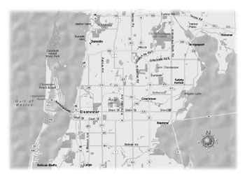 |
| This map shows the Memorial Causeway connecting Clearwater Beach, a barrier island, and Clearwater on the mainland. During rain events, traffic signals on Route 60 automatically adjust to allow longer green times. |
Access restrictions during inclement weather can include road and bridge closures; access limitations for specially-equipped vehicles, such as those with tire chains; or access restrictions for certain vehicle types, such as tractor trailers. For example, severe wind tunnel conditions frequently occur on a 13-kilometer (8-mile) section of Interstate 90 in Bozeman/ Livingston, MT. The Montana Department of Transportation manages vehicle access to the interstate with the help of four dynamic message signs (DMS) that warn motorists of high-wind conditions and restrict access to high-profile vehicles during severe winds. When an environmental sensor station detects severe crosswinds over 63 kilometers per hour (39 miles per hour), the DMS posts a restriction message such as, "Severe Crosswinds: High-Profile Units Exit."
The Advanced Transportation Weather Infrastructure System (ATWIS) uses interactive voice response technology to provide drivers with traffic and weather information for 59,500 highway kilometers (37,000 miles) in Minnesota, Montana, North Dakota, and South Dakota. Cellular telephone users dial #-7-2-3-3 (or #-S-A-F-E™) to access weather and pavement forecasts extending roughly 1 hour or 97 kilometers (60 miles) in their direction of travel. ATWIS also is the basis for road weather data in the regional 5-1-1 traveler information service, which is a part of the national 5-1-1 traveler information program.
During the evacuation before the arrival of Hurricane Floyd in 1999, traffic was severely congested on highways in Florida, Georgia, North Carolina, and South Carolina. By reversing traffic flow (contraflow) on Interstate 26 during reentry operations after the hurricane, traffic and emergency managers in South Carolina expanded roadway capacity and increased the maximum volume of 1,400 vehicles per hour per lane by 49 percent. To alert drivers of contraflow operations, South Carolina positioned portable DMS and highway advisory radio (HAR) transmitters along the interstate.
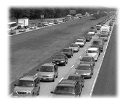 |
| Highway managers in South Carolina used contraflow, or opened both directions of the highway to coastal-bound traffic, to move motorists quickly and efficiently back home after a hurricane. |
A 99-vehicle collision on Interstate 75 in southeastern Tennessee in December 1990 prompted the design and deployment of a fog detection and warning system. The Tennessee DOT installed a motorist warning system covering a 4.8-kilometer (3-mile), fog-prone section above the Hiwassee River and 12.9-kilometer (8-mile) road sections on both sides of the river. A central computer system predicts and detects conditions conducive to fog formation by continually monitoring data from 2 environmental sensor stations, 8 fog detectors, and 44 vehicular speed detectors. The computer system alerts traffic and emergency managers when established threshold criteria are met, correlates field sensor data with predetermined response scenarios, and recommends responses based on prevailing field conditions.
Responses include warning motorists via 2 HAR transmitters; flashing beacons atop 6 static signs and 10 dynamic message signs; reducing speed limits with 10 variable speed limit signs; and restricting access to the affected road segment using 8 ramp gates. Managers select preprogrammed DMS messages, prerecorded HAR messages, and appropriate speed limits, such as 65, 50, or 35 mph, based upon response scenarios proposed by the system. Under the worst conditions (i.e., visibility less than 73 meters or 240 feet), the Highway Patrol activates automatic ramp gates to close the freeway and detour traffic to U.S. Route 11.
On U.S. Highway 189 near Jackson, the Wyoming DOT uses an avalanche warning system to detect avalanches, warn motorists approaching the avalanche area, and alert maintenance personnel working in the area. The computerized warning system continuously monitors tilt switch sensors, strung across the avalanche path 300 meters (or 980 feet) above the roadway. At the onset of an avalanche, the system automatically activates flashing beacons atop static road signs to caution motorists and triggers audible alarms in maintenance vehicles to notify maintenance staff that may be in the avalanche path.
The avalanche warning system improves safety by minimizing risks to the traveling public and maintenance personnel. After an avalanche, the system also facilitates timely roadway inspections, snow and debris removal activities, and road closure or rescue operations. By integrating road weather data into decisionmaking processes, transportation managers can counter weather-induced problems effectively and deliver credible, customized traveler information that enables motorists to avoid unsafe conditions and better cope with weather effects on roadways.
For further details about weather-related best management practices or to request a copy of the CD-ROM, contact:
Paul Pisano 202-366-1301 paul.pisano@fhwa.dot.gov
With more than 40,000 highway deaths and approximately 6 million highway crashes in the United States each year, transportation professionals seek out solutions from other countries to decrease these numbers and increase roadway safety. European countries sometimes use different approaches than ones typically used in the United States, resulting in significant innovations that save people's lives. It was the job of a U.S. delegation sent to Europe to discover and review supporting mechanisms used in planning, developing, and implementing successful highway safety programs.
The U.S. delegation was comprised of an array of professionals within the highway safety community, including officials and representatives from Federal Highway Administration (FHWA) and the American Association of State Highway Transportation Officials (AASHTO), two universities, and five State departments of transportation (DOTs). Sweden, Germany, the Netherlands, and the United Kingdom were selected because of each country's recent success in reducing highway fatalities, highway safety records and experience, and international reputation for cooperation and coordination within highway safety programs.
The U.S. team found some commonalities. Each country views highway safety as a public health or quality of life issue and bases its safety decisions and targets on a common philosophy. Their safety plans are comprehensive and coordinated, with each country taking a proactive approach to highway safety that includes a fully integrated and nationally accepted plan. The national plan forms the basis of the regional and local safety plans and targets. Three of the four countries had measurable and deliverable fatality and/or injury reduction targets.
The delegation also found several common program elements in these countries, including:
 |
| Variable speed limite signs, like these on a highway in the Netherlands, dynamically adjust speed limits according to the amount of traffic on the road. |
Based on the information gathered abroad during the scan tour, the U.S. delegation offers the following recommendations for consideration in the United States:
For more information about the highway safety scan tour or the team's recommendations, contact:
Michael S. Griffith
Michael L. Halladay 202-366-9469 michael.halladay@fhwa.dot.gov
John Baxter 317-226-7476 john.baxter@fhwa.dot.gov
The Federal Highway Administration (FHWA) and the Federal Transit Administration (FTA) plan to release the 2002 Status of the Nation's Highways, Bridges, and Transit: Conditions and Performance report to the U.S. Congress by fall 2002. FHWA and FTA are putting the final touches on this fifth report, which is a virtual report card on the status of programs and infrastructure related to highways, bridges, and transit systems in the United States.
Also known as the C&P report (Conditions and Performance), the document consolidates data provided by States, local governments, and mass transit operators into one national report appraising highway, bridge, and transit physical conditions, operational performances, financing mechanisms, and future investment requirements.
The C&P report contains five major sections. Parts I and II analyze the current performance and future needs of the surface transportation system. Part III describes the conditions, composition, and performance of bridges and includes a discussion of the Highway Bridge Replacement and Rehabilitation Program and the National Bridge Inspection Program. This section replaces the report to Congress on The Status of the Nation's Highway Bridges. Part IV details the analysis process used for Parts I and II. Part V consists of three technical appendices that describe the investment and performance methodology.
The earliest versions of the C&P report relied exclusively on engineering-based estimates for future investment requirements, which considered only the costs for transportation agencies, excluding costs to transportation users. These newer methods use benefit-cost analyses to help minimize capital investment and user costs to achieve improved levels of highway performance. Analyses in the new report use an economic overlay to project future investment requirements. The authors developed the analyses of future investment requirements specifically for this document, and they provide national projections.
At more than 450 pages long and featuring more than 400 tables and charts, the C&P report is comprehensive and detailed. Officials at all levels of government, national and international news media, transportation associations, and industry groups will find the C&P report to be an ideal tool for use in developing or evaluating legislative, program, and budgeting alternatives.
Prior to 1993, FHWA and FTA issued separate reports on the conditions and performance of the Nation's highway systems and transit systems. In 1993, the U.S. Department of Transportation (USDOT) combined the existing reports to cover both highways and transit together in one report. USDOT released the last C&P report in May 2000.
FHWA and FTA will publish the completed report and make it available to the transportation community via the FHWA Web site at www.fhwa.dot.gov. In addition, the agencies will furnish a complete HTML Web version of the report at a later date. For more information about the report, contact:
Jon Schans 202-366-9214 jon.schans@fhwa.dot.gov
 |
 |
 |
| The C&P report updates Congress on the status of the Nation's highways, bridges, and transit systems. | ||
Pontis is a powerful bridge management software program that stores data on bridge inventory, condition history, and project tracking information in a large database. The software enables bridge managers to analyze bridge data using a series of simulation, optimization, and evaluation tools to predict future bridge conditions and needs, develop optimal bridge policies, and recommend bridge projects and schedules within policy and budget limitations.
At a 2001 Pontis users' group meeting, several representatives from State transportation agencies expressed an interest in learning more about how to use the program most effectively. The group's interest in fine-tuning their Pontis usage led to the Federal Highway Administration (FHWA) and the American Association of State Highway and Transportation Officials (AASHTO) teaming up to develop a 3-day National Highway Institute (NHI) training course.
The course is geared primarily toward bridge program managers, management and maintenance engineers, inspectors, and project planning and programming personnel. But the course also provides an overview session targeted at Federal, State, and local executives and upper- and mid-level highway agency professionals responsible for an agency's bridge or highway program.
During the course, instructors demonstrate the applicability of each of the Pontis bridge modules (inspection, preservation, programming, project planning, configuration, gateway, and reports) so course participants gain a clear understanding of the software and its uses. Workshop instructors use practical exercises-entering and editing inspection data, developing preservation policies, analyzing bridge needs, and developing bridge projects-to demonstrate day-to-day uses for the software.
More than 25 people attended a pilot course presented in early May 2002 in Santa Fe, NM. In addition to the pilot, NHI instructors also conducted Pontis software training classes in New Jersey and Delaware in July, and Utah in August. AASHTO reports that more than 40 State departments of transportation and other agencies already are licensed to use the software. For more information, visit the NHI Web site at www.nhi.fhwa.dot.gov.
George Romack

