U.S. Department of Transportation
Federal Highway Administration
1200 New Jersey Avenue, SE
Washington, DC 20590
202-366-4000
Federal Highway Administration Research and Technology
Coordinating, Developing, and Delivering Highway Transportation Innovations
|
Research & Technology Transporter This newsletter is an archived publication and may contain dated technical, contact, and link information. |
|
| Publication Number: N/A Date: January 2003 |
Publication Date: January 2003
|
At the end of some government projects, the leftover equipment gathers dust in a warehouse, is thrown away, or is sold, even though it may have many more years of useful life. A recent donation from the Federal Highway Administration (FHWA) to California Polytechnic State University (Cal Poly) in San Luis Obispo, CA, will breathe new life into equipment from a completed project and provide hands-on learning for future transportation engineering students.
In November 2002, FHWA donated its Demonstration Project 105 trailer to Cal Poly's Advanced Research and Development Facilities and Activities Center. FHWA and Cal Poly had developed the unique trailer to showcase traffic surveillance and control technologies to local transportation officials who might not otherwise see the technologies in action. Equipment on display in the trailer includes freeway and traffic signal management systems, weather detection devices, changeable message signs, electronic fare collection devices, and video surveillance cameras.
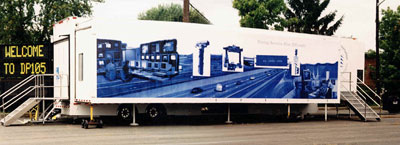 |
| FHWA donated the trailer shown here to California Polytechnic State University, which will use it in its transportation courses. |
At its new home at Cal Poly, the trailer will be used for undergraduate transportation engineering instruction and research, and for joint programs with the California Department of Transportation (Caltrans).
"I taught our new civil engineering intelligent transportation systems course last winter, and we were able to take advantage of the capabilities of [the trailer]," says Jeff Gerfen, project director and research engineer at Cal Poly. "We're planning to use the trailer for this course and for similar training activities, both on campus and in various Caltrans districts."
From 1997 to 2001, engineers at Cal Poly took the trailer on a nationwide tour sponsored by FHWA. The trailer visited more than 65 cities. Transportation professionals in each city either participated in short walk-throughs or took part in a 2.5-day course on the basics of technology deployment.
"We are delighted that Cal Poly will continue to use the trailer as an educational tool," says Jeff Panianti, associate administrator in FHWA's Office of Operations. "The program and its partnership have been very successful in demonstrating the intelligent transportation system technologies that are so important in improving safety and relieving traffic congestion."
Larry Swartzlander 202-366-6066 larry.swartzlander@fhwa.dot.gov
Between 1980 and 2000, highway travel in the United States increased 80 percent, and the number of drivers increased by 30 percent, while the miles of highway constructed during that time increased only 2 percent. One way States are handling roadway crowding is by creating toll lanes, a form of managing lanes. Because most traffic forecasting tools currently on the market cannot evaluate toll options against more traditional "free" highway alternatives, the Federal Highway Administration (FHWA) recently released an updated tool designed specifically for examining toll options and managed lanes.
The Spreadsheet Model for Induced Traffic Estimation with Managed Lanes (SMITE-ML) is an update to the previously released Spreadsheet Model for Induced Traffic Estimation. SMITE-ML enables transportation decisionmakers to evaluate the traffic, economic, and financial impacts of managed lanes, such as High-Occupancy Vehicle (HOV) lanes, High-Occupancy Toll (HOT) lanes, and Fast and Intertwined Regular (FAIR) lanes in urban settings.
FHWA developed SMITE-ML to perform corridor-level analyses. The tool uses data on travel demand and price elasticity to estimate increases in vehicle mileage resulting from faster travel speeds on the roadways, including new trips due to capacity expansion and existing trips diverted from other destinations and other travel modes such as transit.
Coinciding with and complementing the launch of SMITE-ML, FHWA published a case study on using quick-response analysis tools to evaluate toll options for a segment of the Washington Capital Beltway-the 101-kilometer (63-mile) highway that rings the Nation's capital. The case study evaluates three pricing alternatives using toll options in managed lanes and compares the results to the traditional improvement alternatives being studied for the Beltway.
The case study uses the SMITE-ML model to show that the cost per hour of delay is lowest with the FAIR lanes alternative. It also is lower with other pricing alternatives when compared with the traditional strategy of simply expanding the road or adding lanes. FHWA presented a paper on the case study at the Transportation Research Board's annual meeting in January 2003 in Washington, DC. Information about the paper and SMITE-ML is available at www.fhwa.dot.gov/steam/smiteml.htm.
Patrick DeCorla-Souza 202-366-4076 patrick.decorla-souza@fhwa.dot.gov
In the past, Federal, State, and local agencies specializing in the "four E's" of transportation safety-engineering, education, enforcement, and emergency services-worked individually on solutions to reduce roadway crashes and fatalities, leading to inefficiencies, duplicative efforts, and a lack of interagency coordination. On September 17, 2002, the Federal Highway Administration's (FHWA) Indiana Division Office, along with 10 other Federal and State transportation agencies and one nonprofit organization that make up the multiagency Leadership Team for Surface Transportation Safety, hosted a 1-day summit in Indianapolis, IN, to discuss new ways for these agencies to collaborate and solve local transportation problems.
At the summit, more than 100 individuals representing the "four E" agencies throughout Indiana formed teams that brainstormed solutions to improving roadway safety. "Among the teams, the consensus was that the 'four E' agencies need to work together to increase driver education and behavior modification programs to help reduce crashes and fatalities," says Kate Weese, city engineer for the City of Carmel, in Hamilton County, IN. "It is time to get back to the root of why crashes occur and work directly with our customers, the drivers, to increase roadway safety." As a result of the summit, the City of Carmel plans to partner with other "four E" agencies in Hamilton County to develop a marketing campaign aimed at educating drivers.
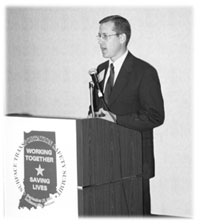 |
| J. Bryan Nichol, commissioner of the Indiana Department of Transportation, discusses the importance of interagency collaboration and the team approach to solving local transportation safety problems. |
Participants also received information about resources and subject experts within their jurisdictions. "The summit taught many participants that help is available outside their own agency, particularly at the State level," says Captain Thomas Melville of the Indiana State Police (ISP). After the summit, the ISP offered assistance to a Clay County school system where vehicle crashes frequently occur as students leave school. The ISP brought in representatives from their problem-oriented policing unit, the Indiana Department of Transportation, and the local Sheriff's department to meet with the school system's transportation director. "We discussed the best ways for everyone to work together to prevent after-school crashes and improve student safety," Melville says.
Other safety issues discussed during the brainstorming sessions and throughout the summit included red-light running, intersection fatalities, speeding, and school and work zone safety. Participants mapped out how they could join forces to address these problems, which also will help ease the burden on individual agencies to solve local transportation problems.
Federal, State, and local officials made presentations on transportation safety issues. J. Bryan Nichol, commissioner of the Indiana Department of Transportation, discussed recent changes in Indiana to improve roadway safety, including adoption of a 0.08 breath-alcohol standard and enforcement of the State's seat belt law through a new focus on pick-up trucks and development of a "Click It or Ticket" campaign.
David Pamplin 317-226-7480 david.pamplin@fhwa.dot.gov
Small and rural transportation agencies are responsible for building or maintaining nearly 4.8 million kilometers (3 million miles) of roadway and more than 29,000 bridges in the United States. Decentralization of research and development across hundreds of transportation organizations, coupled with diverse needs and focus areas in different regions, States, and localities, makes it challenging to transfer the latest cost-saving and cutting-edge innovations, developments, and technologies. Now, local agencies have a new method for learning about the latest advances, processes, techniques, machinery, and tools that will enable them to stretch transportation dollars, create a safer environment, and find better solutions for their transportation problems.
The Federal Highway Administration's (FHWA) Local Technical Assistance Program (LTAP) launched an innovative Product Demonstration Showcase (PDS) Program to expedite technology transfer and implementation at the local level. Although the program started in 1998, the LTAP in Florida is starting to see success with a new PDS implementation method. The PDS Program works with private industry and other organizations to create events that professionals can attend to learn about and try new transportation products and technologies. The program also features "how to" sessions to show the proper techniques for implementing and using these products and technologies. With a new Web site at www.pdshowcase.org, the PDS Program is looking at ways to duplicate this success nationwide.
"Local officials do not want to listen to a salesman telling them how great a new product or service is," says Gib Peaslee, coordinator of the PDS Program for LTAP in Florida. "Before they buy a new technology or implement a new program, they want to see or hear about the product or process from peers who have tried them. The PDS Program gives them the opportunity to do this, and the Web site makes it easy to find out about upcoming showcases."
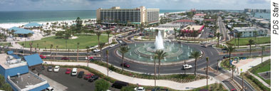 |
| This well-designed roundabout—the subject of a showcase held in September 2000—reduced congestion and improved traffic flow in the beach community of Clearwater, FL. |
The Web site has a number of features to help transportation officials find a showcase that meets their needs, including a schedule of upcoming events, detailed showcase agendas, and information to assist agencies interested in sponsoring their own showcase events. Users also can register on the site to attend showcases.
"Without the Web site and the online registration, we would not have nearly the attendance that we have had around the country," adds Peaslee. "The site is a useful tool for promoting the showcases and provides a convenient way for busy transportation professionals to register for an event."
Upcoming showcases include a 3-day workshop in Pensacola, FL, from April 1-3, 2003, about pavement preservation from the Escambia County Engineering and Road Divisions teams, five contractors, and two manufacturing representatives. In Logan, UT, on April 29, 2003, a 1-day showcase focuses on adjustable manhole covers. Attendees will visit sites where the covers are in use and will have an opportunity to observe a real-time field installation of the adjustable covers.
Bill Evans 303-969-5772 ext. 330 william.evans@fhwa.dot.gov
For decades, researchers have been trying to determine how water and Portland cement powder react during the concrete setting process. This reaction plays a vital role in determining concrete setting times, which affects how quickly drivers can begin using newly paved roadways. To evaluate the reaction, the Federal Highway Administration's (FHWA) Advanced Research program is applying, for the first time, an analytical method known as nuclear resonance reaction analysis (NRRA). The results will be used to improve cement industry standards and guidelines for mixing and curing concrete.
The method uses a beam of nitrogen atoms to probe a reacting cement grain to locate hydrogen atoms, a necessary component of water, or its reaction products. The results of the probe are plotted in a graph called a hydrogen depth profile, which shows the rate of penetration of the water. This also indicates the arrangement of the various surface layers formed during the reaction.
The 20-nanometer-thick surface layer acts as a semi-permeable barrier that allows water to enter the cement grain and calcium ions to leach out. However, the larger silicate ions in the cement are trapped behind this layer. As the reaction continues, a silicate gel layer forms beneath the surface layer, causing swelling within the cement grain and eventually leading to breakdown of the surface layer. This breakdown releases the accumulated silicate into the surrounding solution, where it reacts with calcium ions to form a calcium-silicate hydrate gel, which binds the cement grains together and sets the concrete. This resolves a scientific debate that has been going on for more than a century.
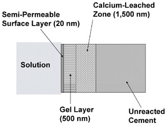 |
| The arrangement of various surface layers on a cement grain as determined from the hydrogen depth profile. |
The evolution of the hydrogen profile shows the time of breakdown of the surface layer. This information can be used to study the concrete setting process as a function of time, temperature, cement chemistry, and other factors. For example, researchers used NRRA to determine that in cement hydrating at 30°C (86°F), the breakdown occurs at 1.5 hours.
FHWA plans to continue the NRRA research for at least 3 more years in collaboration with the University of Connecticut, which received a National Science Foundation grant in September 2002. "We need this kind of fundamental research to achieve leapfrog advances in understanding the mechanisms of the cementing process," says P.N. Balaguru, director of the infrastructure materials and structural mechanics program at the National Science Foundation. "This research also illustrates the effective use of nanotechnology and high-tech equipment for concrete research."
FHWA will continue to develop models that more accurately predict when cements begin to set and evaluate how different chemicals affect concrete setting times. The March 2001 issue of the Journal of Materials Research contains additional information about FHWA's NRRA research.
Richard A. Livingston 202-493-3063 dick.livingston@fhwa.dot.gov
For many years, roadway operations supervisors and motorists were the primary sources of information necessary for making decisions about traffic and transit operations, such as determining how to reroute traffic around crashes and where to send emergency service vehicles. As technology evolved, traffic and transit managers began relying on satellite imagery to provide more accurate and timely transportation information.
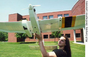
Because satellites are expensive, have cloud cover restrictions, and cannot provide the temporal and spatial resolution needed for precise traffic and parking analysis, the U.S. Department of Transportation's (USDOT) Research and Special Programs Administration, the National Aeronautics and Space Administration, Bridgewater State College in Bridgewater, MA, the University of Massachusetts at Boston (UMass-Boston), and MLB Company of Palo Alto, CA, recently developed an autonomous unmanned aerial vehicle (UAV) to collect and interpret real-time traffic data. UAVs previously served defense purposes only, collecting data for the military. The device is similar in size and shape to a remote-controlled airplane, can be launched in 90 seconds, and flies autonomously using a computer-generated flight plan.
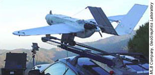 |
| The unmanned aerial vehicle pictured here is easy to transport and operate, and can provide real-time traffic imagery. |
In August 2002, USDOT researchers launched the UAV over Boston, MA, where it provided real-time video to a ground station on the UMass-Boston campus. Using remote-sensing technologies, the UAV performed an aerial survey, documented new land use, provided a clear picture of a central geographic point, and gathered multimodal data using its road-following capabilities. The UAV also produced real-time imagery of a commuter train and traffic conflicts on a major arterial roadway by sending live video photography to the mobile operations computer on the ground.
"To determine what happens when traffic and transit flows converge onto our local streets and State highways takes timing," says Larry Harman, codirector of GeoGraphics Laboratory at Bridgewater State College. "Nothing can compare with having a UAV that can be launched and functioning in seconds, fly itself around designated problem areas, and provide real-time imagery back to the traffic operations and police departments."
The images taken from the flight over the UMass-Boston campus are undergoing analysis at the GeoGraphics Laboratory at Bridgewater State College for application to transit operations and infrastructure security. Preliminary findings show that remote-sensing images from UAVs could provide an unprecedented level of detailed information to traffic and transit managers and transportation researchers, especially if used with automatic vehicle location systems and other flow-monitoring technologies. The data could be a highly effective source of information for responding to local traffic problems affecting surface transit.
 |
| A staff member of the MLB Company launches a UAV. |
UAVs are available in many sizes, ranging from 3.6 kilograms (8 pounds) to more than 1,000 kilograms (2 tons). UAVs that weigh less than 25 kilograms (55 pounds) and are controlled from the ground are licensed as model airplanes and have far fewer FAA restrictions than UAVs flying autonomously. The 4.54-kilogram (10-pound) UAV used in Boston has the most updated safety features, including an automatic "go home" feature, should communications between the ground and the device become interrupted, and an automatic engine shut-off with parachute deployment.
David Gibson 202-493-3271 david.gibson@fhwa.dot.gov
With approximately 25,000 steel bridges in the United States that potentially are vulnerable to cracking and other failures, inspectors need the most up-to-date techniques and technologies. In 2002, the Federal Highway Administration's National Highway Institute (NHI) developed a new 3.5-day course, Fracture Critical Inspection Techniques for Steel Bridges (#130078A), which provides participants with information on crack initiation and propagation, failure mechanisms, and places to look for fractures on steel bridges.
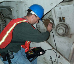 |
| Using ultrasonic testing, an inspector checks a steel bridge pin. |
The new course replaces an older course, Inspection of Fracture Critical Bridge Members (#13036). NHI reformatted and expanded the course to include hands-on workshops for employing popular types of nondestructive testing equipment, including dye penetrant, magnetic particle, and ultrasonic testing. The updated curriculum reflects current practices and addresses new and emerging technologies for bridge inspectors, such as the expanded use of electrical currents and acoustic sensors for testing and characterizing bridge imperfections.
Upon completing the course, participants will be able to:
Bridge inspectors, supervisors, project engineers, maintenance engineers, shop inspectors, shop foremen, and others responsible for the fabrication and field inspection of fracture-critical steel bridge members will benefit most from the training. Participants should have completed NHI's course, Engineering Concepts for Bridge Inspectors (#130054) and/or Safety Inspection of In-Service Bridges (#130055), or possess equivalent field experience to understand bridge mechanics and safety inspection procedures as required by the National Bridge Inspection Standards.
To learn more, consult the course catalog on NHI's Web site at www.nhi.fhwa.dot.gov. For scheduling, contact Danielle Mathis-Lee at 703-235-0528 or danielle.mathis-lee@fhwa.dot.gov. For technical information, contact Tom Everett at 410-962-3743 or thomas.everett@fhwa.dot.gov.
Leslie Wright 703-235-1260 leslie.wright@fhwa.dot.gov

