U.S. Department of Transportation
Federal Highway Administration
1200 New Jersey Avenue, SE
Washington, DC 20590
202-366-4000
Federal Highway Administration Research and Technology
Coordinating, Developing, and Delivering Highway Transportation Innovations
|
Research & Technology Transporter This newsletter is an archived publication and may contain dated technical, contact, and link information. |
|
| Publication Number: N/A Date: July 2003 |
Publication Date: July 2003
|
Building traditional bridge abutments—the structures that support the ends of bridges along road or waterway embankments—can be expensive, time-consuming, and labor-intensive due to the costs and complexities of constructing the deep foundations needed to support the abutments.
To evaluate a possible alternative, researchers from the Federal Highway Administration, the National Cooperative Highway Research Program (NCHRP), and the University of Colorado at Denver recently load-tested a full-scale support structure constructed of geosynthetic-reinforced soil (GRS). The tests were part of NCHRP project 12-59, Design and Construction of Geosynthetic Reinforced Soil Abutments for Bridge Support.
GRS is composed of alternating layers of compacted soil and thin sheets or grids of geosynthetic reinforcements made from polymer plastics. The facing element is typically a segmental concrete modular block, which acts as a façade and is not considered to offer any structural support. Researchers believe that support systems made from GRS offer a number of advantages over traditional earth retainment systems. They are more forgiving to differential settling in the foundation, as well as being quicker and more economical to build. They can also be constructed with a variety of soil types and adapted to many different ground conditions.
During the tests, researchers conducted two experiments to assess the load-bearing capabilities of a 24-foot by 19-foot by 15-foot (7.3-meter by 5.8-meter by 4.6-meter) GRS mass made from poorly graded, fine-grain, sand soil. They selected this type of soil to help them identify the lower limits of soil type that would be acceptable for load-bearing applications.
The GRS mass was divided into two halves; the researchers built each half with a geotextile of different strengths to evaluate the impact of reinforcement strength on load-bearing performance. They then tested the two halves separately. To load each half of the block, which rested on a reinforced concrete slab (strong floor), the researchers placed a concrete footing on top of the block, along with steel beams to distribute the load. To apply vertical pressure to the concrete footing, they used hollow-core hydraulic jacks with coupled to five threaded bars anchored to the strong floor.
Results from the experiments indicate that the GRS mass was too soft to withstand the load, and a bearing pressure of 200 kilopascals (29 pounds per square inch) is too heavy for a GRS mass consisting of fine-grain sand. The researchers are now examining how the GRS abutments deformed during the load test. Based on the results, the team will redesign the soil system to withstand loading more effectively, so that one-day GRS abutments can serve as efficient and reliable bridge support systems.
For more information, contact:
Mike Adams 202-493-3025 mike.adams@fhwa.dot.gov
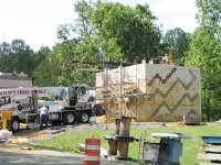 |
| Researchers are performing load tests on a block of geosynthetic reinforced soil, which could someday serve as part of the support system for bridges. |
 |
| Researchers used the hydraulic jacks and threaded bars shown here to place pressure on a block made from geosynthetic reinforced soil. |
According to surveys conducted by the Federal Highway Administration (FHWA), motorists repeatedly list pavement condition as one of their top concerns. Pavements that are in poor condition can fail prematurely and require ongoing maintenance, cost transportation agencies additional money, and cause delays and congestion for motorists. To create high-quality pavements with long design lives, engineers need advanced specifications and effective measures to ensure a high degree of quality control.
In April 2003, the offices of Pavement Technology and Infrastructure Research and Development at FHWA cosponsored the Third Annual Pavement/Materials and Testing Workshop for FHWA Field Engineers. The annual workshops are to transfer technology and contribute towards capacity building in pavements and materials.
The theme of the workshop was “Quality Assurance” (QA). FHWA Deputy Administrator Rick Capka kicked off the event with the opening remarks that highlighted the need for FHWA to continue building its technical capacity and provide technical assistance to State highway agencies, private industry, and transportation associations and organizations.
Experts from Fugro-BRE Consultants, Jim Burati and Dick Weed, led sessions aimed at familiarizing participants with the manual, Optimal Procedures for Quality Assurance Specifications (FHWA-RD-02-095). The manual guides agencies in the development, implementation, and use of QA specifications, certification of personnel, QA acceptance procedures, implementation, and monitoring of existing specifications. The manual also provides step-by-step procedures and systematic procedures to pinpoint pitfalls and where caution should be exercised.
Federal Highway engineers provided presentations on QA programs from the Western Federal Lands Highway Division, results from the 2001 Midwestern Resource Center QA survey, a QA review from the Southern Resource Center, and the Alabama evaluation of the 2002 density test results.
The workshop also featured presentations by representatives from FHWA’s offices of Pavement Technology, Infrastructure Research and Development, Asset Management, Program Administration, and the National Highway Institute on current office programs related to pavement and materials.
Prior to the event’s conclusion, participants identified areas within the QA program at FHWA requiring further guidance and policy, including regulations on quality assurance, staffing levels at State highway administrations, minimum lot sizes and number of samples for performing quality-assurance procedures, and validation of specifications. These areas will have a followup session on the agenda at the Fourth Annual Asphalt/Concrete Materials and Testing Workshop scheduled for December 2003 in Washington, DC.
More than 50 engineers participated in the workshop, which was held in DOT Headquarters, Washington, DC. Attendees included pavement and materials engineers from FHWA’s Federal Lands Highway Program, Resource Center locations, FHWA headquarters office in Washington, DC, and the Turner-Fairbank Highway Research Center in McLean, VA. Participants gained a better understanding of quality assurance practices relevant to their particular needs and interests.
Gene Clark 202-366-4597 gene.clark@fhwa.dot.gov
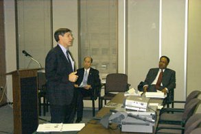 |
| Rick Capka, deputy administrator for FHWA, addresses workshop participants. Also shown from left to right are King W. Gee, associate administrator for infrastructure, and Tommy Beatty, director of the Office of Pavement Technology at FHWA. |
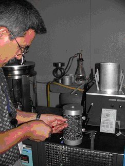 |
| An expert from FHWA’s mobile asphalt laboratory performs QA testing on a specimen. |
Traditional global positioning systems use satellite transmissions to provide information about the specific location of an object within 4 to 20 meters (13 to 65 feet). This level of accuracy, however, is insufficient for some transportation purposes, such as developing collision avoidance systems and providing in-route vehicle guidance. In 1993, the Federal Highway Administration (FHWA) and several other agencies collaborated to create the Nationwide Differential Global Positioning System (NDGPS), which provides location information within 1 to 3 meters (3 to 10 feet). Already recognized as a valuable tool for transportation engineers and planners, NDGPS recently proved useful to students at an environmental education center who were conducting a mapping project in Maryland’s Catoctin Mountains.
In April 2003, researchers from the FHWA Office of Operations Research and Development taught students visiting ThorpeWood, an environmental center located on a 44-hectare (110-acre) nature preserve in Thurmont, MD, how to use NDGPS to survey and map a hiking trail near the center. By helping the students, FHWA demonstrated its ongoing commitment to environmental stewardship and helped train the youngsters that may become the next generation of transportation professionals.
When the mapping is project complete, FHWA and ThorpeWood plan to use NDGPS to plot the location of threatened and endangered plants on the property. These activities will help ensure that future development in the area does not encroach on valuable habitat. Staff at ThorpeWood also will save time in the future when they develop other hiking trails because they will know where to locate the pathways to avoid endangered species and land belonging to other owners.
In addition to ThorpeWood, several Federal, State, and local agencies are using NDGPS for nontransportation purposes. The National Weather Service, for example, uses NDGPS to improve the accuracy of its forecasts and minimize the distortion caused by water vapor during transmissions from traditional GPS systems. In the future, police agencies anticipate using NDGPS to enhance 911 systems by providing more accurate information about the location of incidents.
NDGPS works by comparing the location calculated from traditional GPS satellite to the location of a reference station. The system then transmits information regarding the difference between the satellite derived position and the reference station to a nonstationary receiver held by a user. The receiver uses the information to calculate its exact location. In addition to increased accuracy, NDGPS can provide location information anywhere in the country, including places where most GPS systems are considered unreliable, such as urban and natural canyons or under tree canopies. For more information about NDGPS, visit www.tfhrc.gov/its/ndgps.
Jim Arnold 202-493-3265 james.a.arnold@fhwa.dot.gov
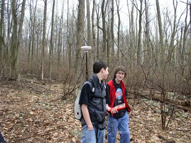 |
| Two students use an NDGPS device to plot the location of a hiking trail near ThorpeWood, an environmental education center in Thurmont, MD. |
In 1996, the U.S. Department of Transportation launched Operation TimeSaver, a program designed to provide metropolitan areas with the infrastructure to deploy and operate intelligent transportation systems (ITS) effectively. The goal of Operation TimeSaver is to build and integrate ITS infrastructure in 75 of the largest metropolitan areas by 2005.
To track progress toward fulfillment of the Operation Timesaver goal, the ITS Joint Program Office at the Federal Highway Administration (FHWA) developed the ITS deployment tracking methodology in 1997. This methodology tracks deployment and integration of nine components of the ITS infrastructure: freeway management, incident management, arterial management, transit management, public safety (fire/rescue and police), electronic toll collection, electronic fare payment, highway rail intersections, and regional multimodal traveler information. Information is gathered through a set of surveys distributed to agencies involved with these components. Deployment is measured using a set of indicators tied to major functions of each component. Integration is measured by assessing the extent that agencies within the infrastructure share information using a set of defined links.
A baseline database was established in a 1997 data gathering targeted at 78 metropolitan areas (3 metropolitan areas were subsequently added to the 75 specified in the Operation Timesaver goal). Updates to these data were performed in 1999, 2000, and 2002. In 2002, in addition to an update of results for the 78 major metropolitan areas, the survey was expanded to include 30 additional medium sized metropolitan areas, 20 tourist areas, and statewide deployments in each of the 50 states. The statewide surveys covered the use of technology to support traffic management, operations and maintenance, crash prevention and safety, transportation weather, and traveler and tourist information. The 2002 survey was distributed to over 2300 state and local agencies, with an overall response rate of 93 percent. Data from all of these surveys are available online at the ITS Deployment Tracking Web Site: http://www.itsdeployment.its.dot.gov.
The Web site offers access to all reports and has data from all the surveys available through a wide variety of search types. Users can query the results by ITS technology type or access results for a particular agency, complete metropolitan area, or nationwide. For each type and location, the site provides detailed information on the characteristics of the deployment, such as the total number of devices currently in use, the number projected to be in use in 2005, and other qualitative and quantitative information. Deployment tracking indicators provide coverage of the deployments, such as the number of freeway miles with electronic surveillance, lanes with electronic toll collection, or transit vehicles with automatic vehicle location technology. In addition, users can compare results across metropolitan areas or download summary reports.
Overall, the survey results reveal that the deployment of ITS technologies has increased significantly, particularly in the most recent survey. Between 2000 and 2002, for example, in the 78 largest metropolitan areas, the number of freeway miles under electronic surveillance increased from 24 to 30 percent, while the number of freeway miles with service patrols to help with incident management increased from 39 to 51 percent. Projections provided by respondents indicate that freeway surveillance will continue to expand in the future, as well as deployments for transit and incident management.
Researchers and companies may find the results of the survey useful in conducting market analyses or to support cost-benefit analyses of ITS deployments. In addition, officials at transportation agencies can use the data to learn from the experiences of other agencies and guide their own decisions about deploying ITS technologies to improve mobility and safety.
For more information about the survey, contact Steve Gordon at 865-946-1313 or gordonsr@ornl.gov.
Joe Peters 202-366-2202 joe.peters@fhwa.dot.gov
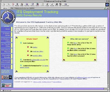 |
| As shown in this screenshot, the results from the 2002 survey on ITS deployment tracking are available at http://itsdeployment2.ed.ornl.gov/its2002. |
Each day, transportation professionals spend valuable time and money searching for information on intelligent transportation systems (ITS) and transportation operations. Finding the right person to contact about a particular type of technology, identifying descriptions of training courses, or locating data on the effectiveness of certain deployments can take hours or even days.
To solve this problem, the ITS Joint Program Office at the Federal Highway Administration (FHWA) published ITS/Operations Resource Guide 2003—an updated, comprehensive listing of more than 400 documents, videos, Web sites, training courses, software tools, and points-of-contact related to ITS and transportation operations.
The original guide was introduced in 2001. Since then, the Joint Program Office has updated the hard copy and online versions of the guide every spring, with additional information added to the online version each fall. This latest guide contains new information on resources pertaining to freeway management and operations, road weather management, highway-rail intersections, transit, ITS standards, and conformity with the National ITS Architecture. Other new additions to the guide include information about the “Compendium of Work Zone Research, Development, and Technology Transfer,” a CD-ROM that features a database of recent work zone-related research, profiles of 332 projects, and a link to download QuickZone, an easy-to-use software tool for calculating traveler delays due to work zones.
Those who will benefit most from the updated guide include engineers, managers, and project designers from Federal, State, and local agencies and the private sector, as well as students and researchers from academia. City traffic engineers, for example, could use the guide to develop strategies for upgrading traffic control systems. By looking in the guide under “Systems Operations: Arterial Operations and Traffic Control Systems,” the engineers would find a list of pertinent resources, including descriptions of training courses on the operation of traffic signal systems offered by FHWA’s National Highway Institute. Other resources include Web sites for relevant reports, a list of experts on traffic control from FHWA and the Federal Transit Administration, and a link to FHWA’s Office of Operations Web site, which features information on arterial management systems.
Although FHWA and other Federal agencies produced most of the resources in the guide, other organizations also contributed material, including the Transportation Research Board, the Institute of Transportation Engineers, and the American Association of State Highway and Transportation Officials.
Users who provided feedback on previous editions indicated that the guide is a valuable tool for transportation professionals. In 2001, the Volpe National Transportation Systems Center conducted a formal evaluation of the guide and reported that two-thirds of those surveyed said they use the guide on a periodic, regular, or extensive basis. More than a quarter of those surveyed described the design, format, and content as “exceptional.”
The updated guide is available in print and online. To request a printed copy, contact the Operations/ITS Help Line at 866-367-7487 or e-mail itspubs@fhwa.dot.gov. Visit the guide online at http://www.its.dot.gov/guide.html.
For more information, contact:
Susan Slye 202-366-1068 susan.slye@fhwa.dot.gov
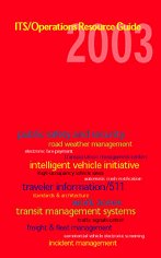 |
| ITS/Operations Resource Guide 2003. |
According to President George W. Bush during Public Service Recognition Week, “America is blessed with dedicated public employees who keep our country strong and ensure that our government functions effectively. Every day Americans serve in a variety of Federal, State, and local government jobs to protect and enhance the lives of their fellow citizens….I commend all public employees for their important service to this Nation and for their invaluable contributions to our future.”
In May 2003, more than 100 Federal, civilian, and military agencies displayed booths and posters, distributed brochures and informational materials, and demonstrated new software and technologies at a 4-day Public Service Recognition Week exposition on the National Mall in Washington, DC. A nonprofit coalition representing nearly 2 million public employees, the Public Employees Roundtable has sponsored the event since 1985 to honor men and women who serve America as Federal, state and local government employees and to educate citizens about the many ways that Government serves the people. Throughout the event, members of the public strolled through the exhibits and learned about the missions and roles of the various agencies.
Federal Highway Administration (FHWA) participated at the event to promote its safety message and emphasize to the public that transportation safety is everyone’s responsibility, from the engineers designing the roads to the pedestrians walking on the sidewalks. Each year, approximately 5,000 pedestrians are killed and 85,000 others are injured in pedestrian-vehicle crashes and the FHWA booth focused on pedestrian safety, with safety experts answering questions about pedestrians walking after dark and nighttime visibility. They also distributed posters promoting pedestrian safety and wristbands made from retroreflective materials printed with the words “Be Safe, Be Bright, Wear At Night.” For more information on FHWA’s pedestrian safety program, visit Pedestrian / Bicycle.
In addition to FHWA, several other agencies within the U.S. Department of Transportation (USDOT) participated in the exposition. The National Highway Traffic Safety Administration (NHTSA) booth focused on air bags and the proper use of child safety seats and booster seats. NHTSA distributed literature on these topics and on the USDOT Auto Safety Hotline (888–DASH–2–DOT) and Web site (http://www.nhtsa.dot.gov/hotline/). Through the hotline and Web site, citizens can request literature on vehicle safety; report defects in vehicles, vehicle equipment, and child safety seats; and find out whether their vehicle or their child safety seat has had a safety-related recall.
People visiting the booth sponsored by the Federal Motor Carrier Safety Administration (FMCSA) learned important safety tips for driving on roads alongside large trucks and buses. FMCSA used the booth to promote its “Share the Road Safely” program—an educational initiative targeting car, bus, truck, and motorcycle drivers, pedestrians, and bicyclists. Representatives from FMCSA distributed materials on the importance of wearing seatbelts and helmets, the hazards caused by blind spots, and proper driving and stopping distances. The goal of the “Share the Road Safely” program is to reduce the fatality rate due to crashes involving large trucks by 41 percent and the annual number of truck-related fatalities to 4,330 by 2008.
In addition to the exposition on the National Mall, other events took place throughout the country in honor of Public Service Recognition Week. For more information about those events, visit www.theroundtable.org/psrwdates.html.
Ann Walls ann.walls@fhwa.dot.gov 202-366-6836
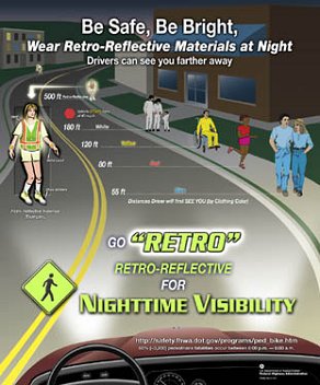 |
| FHWA distributed this poster during Public Service Recognition Week to promote the use of retroreflective materials to increase the visibility of pedestrians at night. |
Researchers at the Federal Highway Administration (FHWA) investigate new technologies and innovations, daily, to improve the Nation’s roadways. However, the Transportation Research Board (TRB) Special Report 261: The Federal Role in Highway Research and Technology and the General Accounting Office (GAO) Highway Research: Systematic Selection and Evaluation Processes Needed for Highway Program (GAO-02-573) suggest that additional improvements can be made to the Research and Technology Program.
To be proactive, FHWA recently started a pilot program to assess the quality and performance of the research at the Agency’s laboratories. In April and May 2003, FHWA brought together a panel of experts to conduct the assessment, focused on the Human Centered Systems (HCS) Laboratory at the Turner-Fairbank Highway Research Center (TFHRC) in McLean, VA.
The assessment was the first to be held at TFHRC and was conducted in accordance with recently developed procedures for the periodic and routine assessment of laboratory research and programs at TFHRC by external panels of experts. The process was modeled in part on the National Academies’ review process for the National Institute of Standards and Technology (NIST) and the State DOT peer exchange program. The objective of the assessment was to provide independent feedback to laboratory managers, FHWA leadership, and partners to improve the quality of laboratory research and services.
Participants in the expert review panel included members of academia and the private sector, and officials from State departments of transportation and the Transportation Research Board. The carefully selected panel listened to onsite presentations by the research staff, toured the facilities, interviewed laboratory stakeholders and customers, and conducted a group discussion with laboratory staff.
Overall, the panel found that the HCS team and support staff are competent and committed, and they work well together. The panel agreed that the lab’s practice of using both simple and complex research methodologies at different stages of research is efficient and appropriate. Examples include analytical analyses, lab experiments, part-task simulations, a full-scale simulator, and field tests.
To improve the lab’s research capabilities, the panel members recommended that computers, software, and other equipment be updated to meet future research needs. The lab also should improve contractors’ access to the research libraries and increase funding for upgrades to laboratory facilities.
The pilot assessment of the HCS lab provided an opportunity for FHWA to learn about ways to improve its research and streamline the review process. The pilot assessment will serve as a benchmark for the HCS lab and a model for future assessments to be conducted in other TFHRC labs, on a regular and recurring basis, in coming years. Assessing all of the laboratories will help enhance the quality, performance, and relevance of FHWA’s research programs; provide technical experts with the opportunity to exchange views; and increase customer and stakeholder confidence in the agency’s research activities.
Donna McEnrue

