U.S. Department of Transportation
Federal Highway Administration
1200 New Jersey Avenue, SE
Washington, DC 20590
202-366-4000
Federal Highway Administration Research and Technology
Coordinating, Developing, and Delivering Highway Transportation Innovations
|
Research & Technology Transporter This newsletter is an archived publication and may contain dated technical, contact, and link information. |
|
| Publication Number: N/A Date: September 2004 |
Publication Date: September 2004
|
Many State departments of transportation (DOT) face situations where reams of valuable geotechnical data-much of which does not change over time-are rendered inaccessible because the agencies lack the means to store and disseminate the information electronically. In general, much of the data obtained in the last decade was not placed in permanent storage and eventually was disposed. Thus, when a State DOT wants to initiate a new project at a location where geotechnical data was previously collected, the agency must undertake a difficult search of archived data or gather the information again. In addition, the data management systems that many transportation agencies currently are using are incomplete and not standardized from agency to agency.
To help solve these problems, Ohio DOT (ODOT) officials are planning to develop an electronic system that will provide easy access to geotechnical information. The Federal Highway Administration (FHWA) Ohio Division Office currently is working with ODOT and several other State DOTs to launch the Geotechnical Management System (GMS) Work Group, an initiative to jointly develop a national framework for such a system. In June 2004, they established the work group, when representatives from the Ohio Division Office and the Consortium of Organizations for Strong Motion Observation Systems cohosted the National Geotechnical Management Workshop to plan development of the GMS.
The ultimate goal of the work group is to create a system known as the Unified Geotechnical Data Access Network to provide one-stop access to available geotechnical data. When complete, the system will consist of a central hub that will link participating geotechnical databases. To develop this system, the participating organizations will adopt standardized software protocols and terminology, and the data will meet the national standard for geographical information systems.
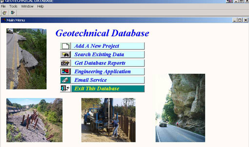 |
| Databases such as this one from Kentucky are the types of systems that Ohio DOT plans to include in the Unified Geotechnical Data Access Network. |
Besides transportation agencies, other potential users that can benefit from the system include natural resource and environmental agencies, consultants, and academics. Benefits of the centralized system may include more efficient retrieval of past data, improved storage of new data, and increased data sharing.
The work group is using a GMS that the United Kingdom Highways Agency is developing as a model. The goal of the work group is to have portions of the GMS functioning within two years and to complete a comprehensive system a few years after that.
Thomas Lefchik 614-280-6845 thomas.lefchik@fhwa.dot.gov
Determining the vulnerability of bridges and tunnels to security threats is a relatively new issue for transportation professionals. The task is of critical importance to national security and public safety because damage to transportation infrastructure could result in significant casualties, high socioeconomic costs, and reduced mobility. Transportation agencies need tools to help them assess the risk of attack on their infrastructure.
To help provide agencies with those tools, officials from the Federal Highway Administration's (FHWA) Office of Bridge Technology recently sponsored a Web-based training session entitled Risk Assessment, Prioritization, and Vulnerability to present information and tools for assessing bridge and tunnel vulnerability. The session was part of a series of Internet training events to raise awareness about the security issues that may affect the transportation system. FHWA designed the training to complement other transportation security efforts currently underway by the U.S. Department of Homeland Security and the American Association of State Highway and Transportation Officials.
FHWA field office representatives and their State and local counterparts connected to the Web from 57 locations to view the presentation and hear and participate in the live, simultaneous audio transmission. The session focused on the application of an equation typically used to calculate the risk of natural disasters to today's security environment. The equation uses several factors to determine the risk of attack, including the socioeconomic importance of the facility, the likelihood of a threat occurring, and the vulnerability of the facility. Each factor depends on several other variables. For example, the likelihood of a threat occurring depends on whether the facility is highly visible, whether an attack would generate wide publicity, or if previous threats were made against it.
During the training session, the participants learned how to apply the equation to each component of a structure. On a suspension bridge, for example, transportation agencies must assess the support towers, anchors, and suspenders individually to predict the consequences of damage or destruction. The information gathered through this process is integral to determining the necessary next steps, which can either be directed toward preventing the threat by controlling access to the facility or toward mitigating the consequences of an attack by using engineered solutions for hardening a structure to prevent damage. Using the risk equation to identify vulnerabilities in highway infrastructure helps transportation officials set priorities that address security concerns in existing infrastructure and design defensible bridges and tunnels in the future.
Two other Web-based training sessions in this series have been held: Emergency Response, Planning and Preparedness and Military Deployment Support and Continuity. The final session, Freight and Border Security, is scheduled for September 9, 2004. To learn more about the final session, contact John Gerner at johngerner@fhwa.dot.gov or 202-366-0507. In addition, FHWA will conduct a 1-day course in fall 2004 on structural toughening and vulnerability assessment. For more information, contact:
Steve Ernst 202-366-4619 steve.ernst@fhwa.dot.gov
Adverse weather is the second largest cause of nonrecurring congestion. Snow, ice, and fog alone cause 15 percent of nonrecurring delay. Likewise, a light rain can increase travel time delays by 12 to 20 percent. Access to real-time weather updates can enhance roadway safety and reduce congestion by keeping travelers informed about conditions that can affect travel.
One way to make weather and other traveler information available to the public is through information kiosks located along roadways. In Nebraska, the Federal Highway Administration (FHWA) is providing funds through the National Scenic Byways Program to install 30 state-of-the-art information kiosks across the State. Known as N-View, the project is one of the first in the Nation to combine both tourism and weather information on each machine. The Nebraska Department of Roads, Nebraska Department of Economic Development's Division of Travel and Tourism, and the State's nine Scenic and Historic Byways are cosponsoring the project.
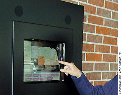 |
| Nebraska's new N-View kiosks, shown above, provide both tourist and weather information using video, graphics, and onscreen text. |
The N-View system will include10 kiosks along Interstate 80 (I-80) and 20 kiosks at the entry points to each of Nebraska's Scenic and Historic Byways. The 30 kiosks have the potential to influence the travel decisions and route choices of more than 500,000 travelers per year on the State's highways and byways. A kiosk prototype-located on I-80 near Seward-averaged 100 users per day during a nine-month test period.
The touch-screen kiosks are computer-based and designed to deliver information to the user in the form of video, graphics, and onscreen text. The National Weather Service will provide real-time weather information via satellite displayed on weather maps and charts at each kiosk. The tourism information will include details on attractions, events, and accommodations throughout Nebraska, a State where the tourism industry produces $2.8 billion each year.
The U.S. Congress created the National Scenic Byways Program in 1991 to promote the recognition and enjoyment of America's most memorable roads. The program provides merit-based funding for byway-related projects. The Nebraska Byways Program, composed of nine official State byway organizations, is designed to showcase outstanding archaeological, cultural, historic, natural, recreational, and scenic sites along Nebraska's two-lane highways.
For more information on the N-View project, contact Jim Pearson, Nebraska Department of Roads, at 402-479-4881 or jpearson@dor.state.ne.us.
Ed Kosola 402-437-5973 edward.kosola@fhwa.dot.gov
To build safer and more efficient roads, transportation researchers and engineers must understand many factors and the interaction of these factors, including how road design and vehicle features contribute to driver performance under daytime and nighttime conditions. In addition, many human factors contribute to driver performance, including age, driving experience, and vision. Virginia's Smart Road-a new facility developed by the Virginia Department of Transportation (VDOT) and the Virginia Tech Transportation Institute (VTTI)-has become an important resource in the effort to understand the interaction of road design, vehicle features, and driver performance. Located in Blacksburg, VA, the Smart Road is a highly instrumented 4-kilometer (2.5-mile) section of limited-access design highway operated by VTTI, VDOT, and the Virginia Transportation Research Council.
To keep up-to-date on the important research undertaken on the Smart Road, representatives from the Federal Highway Administration's (FHWA) Office of Safety Research and Development recently visited the facility for briefings and demonstrations.
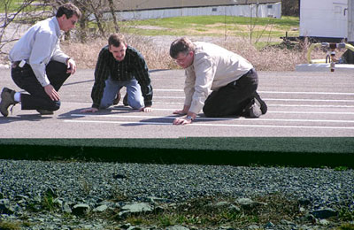 |
| Representatives and staff from FHWA, VDOT, and VTTI closely examine and compare different pavement markings that researchers are using on the Smart Road in visibility experiments under wet, nighttime conditions. |
The briefings by the VTTI staff provided FHWA representatives with information about some of the cutting-edge research currently underway to improve traffic control, highway lighting, traffic control device design, and driver training, and assess the impacts of emerging vehicle technologies. In addition, the FHWA representatives had the opportunity to learn about and see Smart Road features. The briefings focused on the progress of several projects that are active or nearing completion, including:
Kenneth Opiela 202-493-3371 kenneth.opiela@fhwa.dot.gov
Historically, traffic and transportation engineers have treated network planning and operational analyses as two distinct functions. In recent years, however, the use of intelligent transportation systems (ITS) to plan and operate the Nation's transportation network has increased. In addition, the Transportation Equity Act for the 21st Century (TEA-21) requires transportation planners to promote efficient system management and operations as part of the transportation planning process. Due largely to these changing demands, engineers face an increasing need for tools that unify planning and operations analyses in a single, dynamic format.
To meet this need, the Federal Highway Administration (FHWA) is releasing DYNASMART-P-a computer-based tool produced by FHWA's Dynamic Traffic Assignment research project. DYNASMART-P supports decisions involving transportation network planning and traffic operations, such as evaluating options for ITS deployment. The tool uses simulation-based dynamic network assignment models, which traditionally have been used in conjunction with demand forecasting procedures for planning applications, and traffic simulation models, which generally have been utilized in traffic operational studies.
By combining these models and procedures, DYNASMART-P makes it possible to model the evolution of traffic flows based on the decisions of individual travelers seeking the best paths through a simulated region. Unlike the planning devices currently used by most transportation professionals, DYNASMART-P is a dynamic tool that overcomes the known limitations of its static counterparts and enables engineers to address the policy issues that planning agencies increasingly face, such as how to optimize travel conditions and minimize the environmental impacts of transportation.
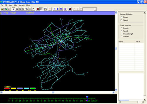 |
| In this image, the DYNASMART-P tool simulates the traffic network in Knoxville, TN, using color-coded links to indicate the time-varying speeds of travelers on a minute-by-minute basis. |
Through its graphical interface, DYNASMART-P enables users to view-on a minute-by-minute basis-animated, time-varying densities, speeds, queuing lengths, and vehicles on network links over an entire planning horizon that typically spans several hours. In addition, users can zoom in and focus on specific areas of interest to see how traffic conditions evolve over the analysis time period.
Since DYNASMART-P considers the time-varying nature of traffic flows, FHWA expects that the new tool will produce more useful estimates of variables such as speed, queue length, delay, and congestion. Potential applications of DYNASMART-P include planning and managing work zones, analyzing congestion pricing schemes, and planning for special events and emergency situations.
DYNASMART-P operates on recent versions of the Microsoft® Windows® operating system. To assist users in preparing input data for DYNASMART-P, FHWA has developed DSPEd-an input editor for DYNASMART-P. Both DYNASMART-P and DSPEd will be available in fall 2004 at http://mctrans.ce.ufl.edu. In addition, FHWA and the University of Maryland will offer at least two free, 2-day training workshops in the Washington, DC, metropolitan area at the end of September 2004.
For more information about DYNASMART-P, visit www.dynasmart.com or www.dynamictrafficassignment.org. For more information on the training workshops, contact:
Henry Lieu 202-493-3273 henry.lieu@fhwa.dot.gov
The chemical and physical properties of different types of asphalt affect the material's performance as a component of pavement. In the late 1980s, through the Strategic Highway Research Program, researchers began developing methods for specifying asphalts based on their performance characteristics, and that work continues today through ongoing research efforts at the Federal Highway Administration (FHWA) and other organizations. Despite advancements in the scientific knowledge of asphalts, many issues remain unresolved, such as the most effective ways to prevent moisture damage in asphalt pavement.
With support from FHWA, Western Research Institute organized the 41st annual Petersen Asphalt Research Conference, which provides a forum where pavement engineers and others can present the results of research aimed at improving the specification and performance of asphalt. In June, more than 100 researchers, highway agency representatives, and asphalt producers attended the 2004 conference in Cheyenne, WY.
In one presentation, Dr. Hussain Bahia described the results from a University of Wisconsin-Madison laboratory study designed to help highway agencies choose between an antistripping additive and polymer modification to reduce susceptibility to moisture damage. The study evaluated three properties of asphalts modified with antistripping additives and polymers: (1) adhesion, which is the force holding two different pavement materials together, (2) cohesion, which is the attraction between the particles in pavement material, and (3) rutting, which refers to the deformation of pavement surfaces caused by wheels. The results showed that although both antistripping additives and polymers offer protection against moisture damage, polymers physically change the nature of the asphalt itself, improving rutting performance and resistance to moisture damage.
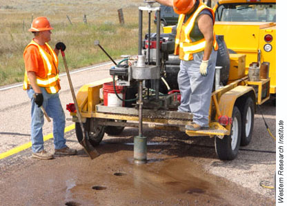 |
| Workers drill out road core samples at Western Research Institute's test site in Wyoming to validate asphalt performance. The institute recently organized the 41st annual Petersen Asphalt Research Conference. |
In another presentation, Joseph Rovani of Western Research Institute discussed the use of gel permeation chromatography (GPC) as a fast and reliable new method to determine the polymer content in asphalt. GPC is a test method that separates molecules in a substance according to their molecular size. Since polymer molecules typically weigh 10 times more than asphalt molecules, researchers can identify them easily using this method. In GPC tests on eight asphalt samples, researchers correctly identified all cases in which samples had been modified with polymers. In the future, professionals at highway agencies may use the GPC test as a tool for quality assurance to verify that the content of a polymer-modified asphalt-which can cost approximately $100 per ton more than unmodified asphalt-meets the agency's specifications.
Following the conference, FHWA's Turner-Fairbank Highway Research Center and the Western Research Institute cosponsored a 2-day Pavement Performance Prediction Symposium. The event featured presentations focused on the additives used in asphalt road construction and their effects on highway performance. The presentations are available at www.westernresearch.org/content/technology_areas/asphalt_materials/PPPSymp.shtml.
For more information on the conference, visit www.petersenasphaltconference.org or contact Jackie Greaser at 307-721-2249 or jgreaser@uwyo.edu.
Jack Youtcheff 202-493-3090 jack.youtcheff@fhwa.dot.gov
Ernest Bastian 202-493-3075 ernest.bastian@fhwa.dot.gov
Bridge construction or rehabilitation can be a significant source of congestion because of its sequential nature: foundations for piers and abutments must be built first, then pier columns and caps must be built before beams and decks are placed. Accelerated bridge construction and offsite prefabrication technologies can help expedite these processes.
In June 2004, the American Association of State Highway and Transportation Officials (AASHTO) Subcommittee on Bridges and Structures held its annual meeting in Orlando, FL, to address a number of technical topics and issues, including accelerated bridge construction and the use of prefabricated bridge elements to reduce onsite construction time and traffic disruption. In addition, meeting participants focused on the most effective technologies for improving bridge and tunnel security and reviewed and approved changes to design and construction specifications, including those covering steel curved girder bridges.
During the meeting, the subcommittee heard a presentation on a study that the Federal Highway Administration (FHWA) is sponsoring to evaluate state-of-the-art technologies for protecting bridges and tunnels. The goal of the study is to develop better information on the cost, effectiveness, design, and applicability of the various technologies available for protecting vulnerable structures. Researchers plan to produce guidelines that will help State transportation agencies and private bridge operators-including railroads-to determine the benefits of various technologies and select the most appropriate technology for each application.
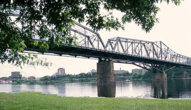 |
| The AASHTO Subcommittee on Bridges and Structures recently met to approve changes to specifications for designing and building bridges, such as the one shown above. |
Also during the meeting, the AASHTO Subcommittee approved several changes to bridge specifications, many of which were developed through FHWA research activities. Among the approved changes were those for steel curved girder bridges. To develop the suggested changes, FHWA conducted a long-term project to produce data that can be used to increase safety and reduce the construction costs associated with curved girder bridges. The project included a recent test on a full-scale bridge-the largest indoor test ever conducted on a curved girder bridge -at the Turner-Fairbank Highway Research Center (TFHRC), in McLean, VA. Developing the new specifications was an essential step toward meeting FHWA and AASHTO's goal of attaining 100 percent usage of the new design code by 2007 for bridges constructed with Federal-aid funds.
In addition, FHWA's Office of Bridge Technology hosted a meeting for all FHWA bridge, geotechnical, and hydraulics engineers attending the AASHTO event. Among the topics discussed at the FHWA meeting was the recent wave of bridge construction-related incidents, some of which involved motorist fatalities. The group reviewed reports on incidents in Colorado, Connecticut, Florida, Ohio, and Texas, and discussed the potential causes. FHWA engineers in States where recent incidents have occurred formed an ad hoc committee that plans to continue analysis of issues related to construction failures and incidents and to review each State's quality assurance and quality control processes for bridge construction.
To download presentations from the AASHTO Subcommittee meeting, visit http://bridges.transportation.org/?siteid=34&pageid=297. For more information on either the AASHTO meeting or the FHWA engineers' meeting, contact:
Ian Friedland 202-366-6712 ian.friedland@fhwa.dot.gov
Within each State department of transportation (DOT), several professionals, including specification writers and pavement design, roadway, geotechnical, and construction engineers, are involved with the definition, design, and construction verification of pavement geomaterials. Completing these tasks requires a solid understanding of the geotechnical aspects of pavements and close cooperation to build and maintain cost-effective pavement structures. In addition to being familiar with sophisticated pavement design models, which rely on skillful characterizations of geotechnical variables, these professionals also must learn about technically advanced tools, such as new procedures for conducting subsurface pavement exploration and real-time evaluations of pavement layers.
To help engineers, specification writers, and others learn about these tools and to facilitate interaction among professionals involved in pavement design, the National Highway Institute (NHI) is offering a course titled Geotechnical Aspects of Pavements (#132040A). The course is the first pavement design class offered by NHI that focuses on geotechnical variables and their influence on pavement design and performance.
Instructors will present the 3-day course using various curriculum materials, such as a reference manual that will be distributed to all participants. They will present the course in an interactive format, using the first-of-its-kind manual as a comprehensive source of information on geotechnical aspects of pavements. The class also will provide an environment where professionals fulfilling traditionally fragmented pavement design responsibilities can learn and share experiences in a common setting.
After completing the course, participants will better understand the geotechnical parameters related to pavement design and construction and the impact of unsuitable subgrades, climate, moisture, and drainage on pavement performance. In addition, they will know how to determine the geotechnical inputs needed for pavement design and construction and how to select appropriate remediation measures for unsuitable subgrades. Participants also will have learned the geotechnical aspects of pavement specifications and inspection requirements.
Although the course has no prerequisites, an undergraduate degree in civil engineering, geology, or equivalent engineering experience in the highway transportation field is desirable.
For more information, contact Sam Mansukhani at 708-283-3550 or sam.mansukhani@fhwa.dot.gov, or Jerry DiMaggio, P.E., at 202-366-1569 or jerry.dimaggio@fhwa.dot.gov.
Nancy Stout 703-235-1260 nancy.stout@fhwa.dot.gov

