U.S. Department of Transportation
Federal Highway Administration
1200 New Jersey Avenue, SE
Washington, DC 20590
202-366-4000
Federal Highway Administration Research and Technology
Coordinating, Developing, and Delivering Highway Transportation Innovations
|
Research & Technology Transporter This newsletter is an archived publication and may contain dated technical, contact, and link information. |
|
| Publication Number: N/A Date: September 2005 |
Publication Date: September 2005
|
In the early morning hours of November 9, 1780, General Thomas Sumter and his American patriots drove Major James Wemyss and his British troops from a field at Fish Dam Ford on the Broad River in Chester County, SC. Along with the better known engagements at Kings Mountain and Cowpens, the skirmish was one in a series of battles that turned the tide of the Revolutionary War in South Carolina and led to the British surrender at Yorktown, VA. Over the years, the exact location of the Fish Dam Ford Battlefield was lost, and many scholars believed the site was destroyed by a quarrying operation. That is, until recently.
While conducting preliminary archaeological studies for a project to replace a bridge over the Broad River, researchers working on behalf of the South Carolina Department of Transportation (SCDOT) inadvertently discovered the location of the long-lost battlefield. To protect the historic site, one of the few undisturbed Revolutionary War battlefield sites in the State, SCDOT and the Federal Highway Administration (FHWA) purchased 143 acres from the landowner and donated them to the South Carolina Department of Natural Resources (SCDNR).
The key to finding the battlefield location was the discovery of a map drawn by battle participant Colonel Richard Winn. A researcher from the Museum of York County in South Carolina found the historic map among Winn's memoirs in the Library of Congress. The map showed that the battle site was on the opposite side of the river from the quarry. After the discovery of the battlefield, SCDOT engineers designed the new bridge to minimize its impact on the historic site.
Archaeological investigations performed as part of the environmental documentation for the project led to the discovery of several rifle pits, or two-man foxholes, and the patriots' campsite. The camp was buried under approximately 2 meters (7 feet) of alluvial sediment deposited by the Broad River during the late 19th and early 20th centuries. The investigators also found unfired musket balls in the rifle pits and at the camp. In addition, the investigators recovered other artifacts from the camp area, including pewter buttons marked "USA."
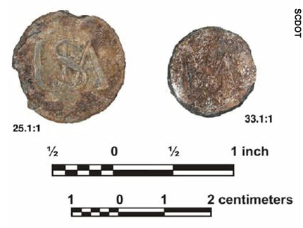 |
| Among the artifacts recovered from the battlefield site were these pewter buttons marked "USA." Photo Credit: SCDOT) |
Purchasing the land not only preserved a historic treasure but also helped the agencies avoid the costs and delays that would have been required for conducting an archaeological excavation before constructing the new bridge. The $300,000 land purchase resulted in a $1.5 million savings over SCDOT's original plan to acquire only 30 acres and conduct invasive excavations. Further, the innovative approach of acquiring and preserving the battlefield supports FHWA's initiative to promote environmental stewardship and streamlining.
In June 2005, FHWA and SCDOT hosted a ceremony attended by Federal, State, and local officials to celebrate the acquisition of the battlefield site. SCDNR will preserve the site under South Carolina's Heritage Trust Program. Created in 1976, the program protects areas of historical, cultural, and archaeological significance and opens them to the public for educational and recreational uses.
J. Shane Belcher 803-253-3187 jeffrey.belcher@fhwa.dot.gov
Wayne Roberts 803-737-1645 robertsWD@dot.state.sc.us
In response to public demand for construction projects to get in and out of urban areas quickly, the American Association of State Highway and Transportation Officials (AASHTO) Highway Subcommittee on Bridges and Structures adopted a resolution in July 2003 supporting the continued implementation of the AASHTO Technology Implementation Group's prefabricated bridge elements and systems (PFBES) initiative. The resolution recognizes that the use of PFBES is consistent with the Federal Highway Administration's (FHWA) goal to mitigate traffic congestion caused by bridge construction projects through the promotion of PFBES technologies.
On December 15 and 16, 2005, FHWA will hold an Accelerated Bridge Construction-Path to the Future Conference in San Diego, CA. The focus of the conference will be on the PFBES initiative and the use of various construction materials and technologies to accelerate the construction of bridges. The target audience for the conference includes design and construction professionals from State departments of transportation and Federal agencies, contractors, fabricators, staff from nonprofit organizations representing related industries, members of academia, and industry representatives specializing in the materials used in the design and construction of bridges.
During the 2-day conference, representatives from several agencies and organizations will make presentations on a number of topics. Benjamin Tang, a principal bridge engineer at FHWA, will lead a session on the international use of accelerated bridge construction. Vasant Mistry, a senior bridge engineer at FHWA, will make a similar presentation focused on efforts in the United States. In addition, conference participants will hear case studies highlighting how accelerated construction has been used successfully to reduce construction time or save money. A presentation by Garth Howlett from PND Incorporated, for example, will feature a discussion of how rapid construction was used on four short-span bridges in Alaska.
The PFBES initiative focuses on a range of technologies that facilitate manufacture under controlled conditions, enabling the prefabricated bridge elements to be taken to construction sites ready to install. Using prefabricated elements reduces onsite construction time, traffic congestion, and the environmental impacts of bridge construction projects and improves work-zone safety for workers and motorists. Because prefabrication can be accomplished in a controlled, offsite environment, without the limitations that job sites can present, the quality of prefabricated bridge elements often is superior to that of traditional bridge elements, and the cost can be lower.
For more information on the conference or to register, visit www.acceleratedbridge.com or contact:
Vasant Mistry 202-366-4599 vasant.mistry@fhwa.dot.gov
Atorod Azizinamini 402-472-5106 aazizi@unl.edu
When much of the Nation's freeway system was built in the 1960s and 1970s, the projected lifespan of the roadways was two decades or less. As a result, many older highways have outlived their original design life and need rehabilitation or reconstruction, which can be costly and time consuming for transportation agencies. In addition, highway reconstruction projects can cause travel delays, safety hazards, and frustration for motorists.
One potential solution is perpetual pavement, an asphalt pavement designed to last for more than 50 years without requiring major structural rehabilitation or reconstruction. In July 2005, the Asphalt Pavement Alliance held a workshop on perpetual pavement in Topeka, KS. Cosponsors of the event included the Federal Highway Administration (FHWA), Kansas Department of Transportation, Kansas State University (KSU), and the State Asphalt Pavement Associations of Arkansas, Kansas, Missouri, and Oklahoma. More than 125 transportation professionals attended sessions on perpetual pavement design and a field trip to a project recently constructed on U.S. 75 in Brown County, KS, that used the new technology.
Dr. Marshall Thompson, University of Illinois professor emeritus, and Dr. David Newcomb of the National Asphalt Pavement Association were among the experts who gave presentations at the workshop. In their talks, they explained that perpetual pavements are built on the principle of confining all distresses to the top asphalt surface layer. This is accomplished by using a stiff and stable pavement foundation, a hot-mix asphalt (HMA) base layer that resists fatigue cracking, an intermediate HMA layer that resists ruts, and a high-quality wearing surface, or top layer. Distresses such as top-down fatigue cracking, thermal cracking, and rutting are confined to the wearing surface. When the distresses at or near the surface reach a critical level, the top layer can be milled and replaced quickly and cost effectively, and the removed material can be recycled.
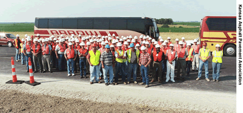 |
| During a recent workshop on perpetual pavements, participants traveled to Brown County, KS, to view a section of perpetual pavement designed with a 50-year lifespan. A large group of participants is shown here standing outside their buses at the Brown County site. (Photo Credit: Kansas Asphalt Pavement Association) |
In another presentation, Dr. Stefan Romanoschi, a professor at KSU, discussed a research study on the perpetual pavement section recently constructed on U.S. 75. To date, the KSU researchers have installed instrumentation between the bottom layers of the perpetual pavement structure and the subgrade to monitor the stresses and strains under traffic loading. The instrumentation will provide information on the performance of the pavement structure. The researchers plan to publish a report when the study is completed.
In addition to KSU staff, representatives from the FHWA Mobile Asphalt Mixture Laboratory were at the U.S. 75 site during construction of the pavement section to conduct performance tests. The mobile lab travels throughout the country to gather data and test new asphalt pavement technologies. Lab technicians performed several asphalt mixture tests at the U.S. 75 project. They also used the Superpave® Simple Performance Tester (SPT) to measure both the dynamic modulus, a stiffness indicator of both cracking and rutting potential at multiple temperatures, and the flow number, which is a repeated load indicator of rutting potential at high temperatures, of the asphalt mixes used on the project. FHWA plans to publish a report summarizing the findings in late 2005.
For more information on perpetual pavement, visit www.asphaltalliance.com. For more information on the U.S. 75 project in Kansas or to obtain copies of the reports, contact:
Kirk Fredrichs 785-267-7299, ext. 326 kirk.fredrichs@fhwa.dot.gov
A personal rapid transit (PRT) system is an automated transit service based on a fleet of small, computerized, driverless vehicles that ride on a track and take passengers directly to their destinations without intermediate stops. Research has shown that an appropriately designed PRT system could improve mobility on a university campus by saving travel time, relieving traffic congestion, and making distant parking lots more accessible to the core campus area. However, the use of PRT systems on large campuses and their surrounding communities remains an untapped method of transport at most universities.
Using a grant from the Kansas Department of Transportation (KDOT), a research team at Kansas State University (KSU) in Manhattan, KS, is conducting a study to investigate automated transit based on robotic vehicles. The purpose of the study is to determine the feasibility and benefits of developing a PRT system at the university, where traffic congestion and a parking crunch have made it difficult for students and faculty to move around the campus. At a May 2005 informational meeting at KSU, the research team reported on the progress of its investigation and discussed a scanning study funded by the Federal Highway Administration (FHWA) on the PRT system at West Virginia University. A paper on the study, "Automated People Mover on a University Campus: Mobility Impact Analysis," was presented at the 2004 Transportation Research Board Annual Meeting.
During the meeting, the research team reported that although the automated transit concept is not new, recent advances in vehicle control and computer technology are just now beginning to make it technically and economically feasible. For example, the researchers at KSU used computer modeling to determine that the automated transit concept would, in fact, enhance campus mobility. KSU researchers also are developing a scale model of a PRT test area to demonstrate the sensor and control technology of the envisioned system. In future months, the team plans to investigate ways to reduce the cost of developing and deploying automated transit systems, which is estimated at $5 million to $10 million per mile.
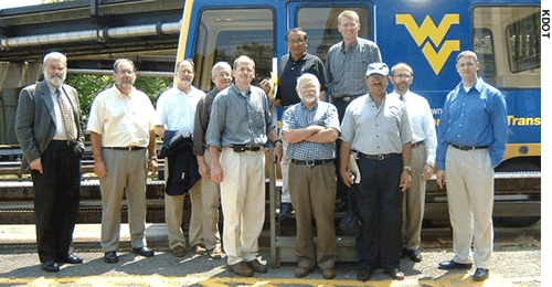 |
| A Kansas delegation visited West Virginia University to study the automated transit system that links the school's campuses. The delegation is shown here standing outside one of the automated transit vehicles. (Photo Credit: KDOT) |
The team also discussed the 2004 scanning study, which gathered information about a PRT system that links the three campuses of West Virginia University (WVU) in Morgantown, WV. The WVU system is the only operating automated transport system in the country that provides origin-to-destination service on demand. A delegation of representatives from KSU, KDOT, FHWA, and the city of Manhattan, KS, visited WVU to study the performance, aesthetics, service history, and maintenance requirements of the WVU system.
Completed in 1979, the WVU system offers service between five stations. Small vehicles carry small groups directly to their destinations without intermediate stops. The system carries approximately 2.5 million passengers each year. Built as a Federal demonstration project, the system had an initial cost estimate of $20 million that rose to a final pricetag of $130 million during the 10 years it took to complete construction. Even after more than 25 years of service, the system still carries people around the WVU campus and is extremely reliable, with the system running nearly 99 percent of the time. For more information on the WVU system, visit www.cities21.org/morgantown_TRB_111504.pdf.
Mark Huffhines 785-267-7299, ext. 329 mark.huffhines@fhwa.dot.gov
Stan Young 785-296-6959 young@ksdot.org
With uncertain funding, a need for coordination among numerous agencies, and continuously evolving technology, how can States overcome the challenges they face in establishing their part of a national 511 travel information network? The answer, in a word, is "together." By sharing information and lessons learned, States are helping one another solve and prevent problems with developing and deploying the 511 network.
One method for sharing information is through interactive Web broadcasts, also known as Web casts. A Web cast held on July 27, 2005, focused on the theme, Rural Issues: 511 and Traveler Information. The event was hosted by the National Transportation Operations Coalition (NTOC), an alliance of the Federal Highway Administration (FHWA), national associations, transportation practitioners, and private sector groups.
The national 511 telephone number is an easy-to-remember resource for travelers who are searching for local weather and traffic information to help them make transportation choices, save time, and avoid congestion. On July 21, 2000, the Federal Communications Commission (FCC) designated 511 as the single telephone number for travel information for all States and local jurisdictions across the country. The FCC ruling leaves nearly all implementation issues and schedules to State and local agencies and telecommunications carriers.
During the Web cast, four presenters broadcast from their offices located throughout the Nation. More than 100 participants listened to the presentations by telephone while viewing slides over the Internet. In addition, an online chat enabled participants to ask questions and make comments.
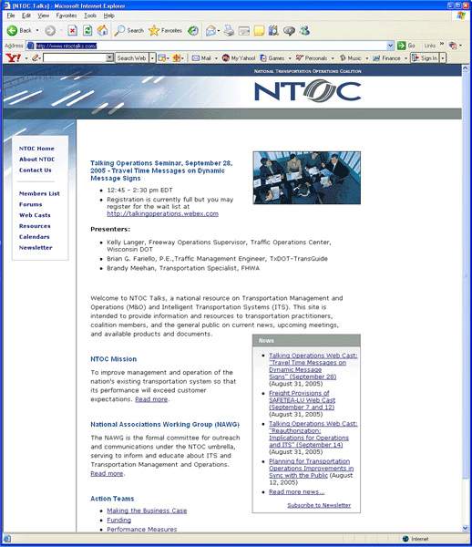 |
| Presentations from the recent Web cast on 511 systems can be downloaded from this Web site at www.ntoctalks.com. |
In the first presentation, Al Kosik, director of the Texas Department of Transportation's (TxDOT) Traffic Management Section, outlined TxDOT's plans for initiating its 511 service. In deploying the system, cost is a major consideration, especially since the system will need to cover large urban areas and interstate corridors across a large State. In addition to deployment, TxDOT is concerned with the costs to operate and maintain the system, which are often greater than the cost of deployment. The first step in TxDOT's deployment strategy is to establish a statewide Web site using traffic information collected by the existing transportation management centers. The phone system will be an extension of the Web site. Callers will be able to access local information first and then listen to a menu of choices to access information from other regions, cities, or corridors in Texas.
Following Kosik's presentation, Robert Rupert, leader of the Transportation Information Management Team in FHWA's Office of Operations, provided the national perspective on implementation of the 511 network. According to Rupert, each State's costs of deployment and maintenance vary greatly, depending on existing capabilities. All costs for deployment and operations, however, are eligible for Federal funding from several sources, including the Surface Transportation Program and the Congestion Mitigation and Air Quality Improvement Program. To date, States generally have used local and State funds to operate the 511 network and a mix of funding sources to pay for deployment costs.
Another presenter, Todd Kell from the private firm PBS&J, representing Scott Cowherd, the 511 travel information program manager in the Operations Management Division of the Virginia Department of Transportation (VDOT), provided a summary of Virginia's 511 program, which began statewide operations in February 2005 and grew out of a regional 511 service. In Virginia, the public can use the 511 service to receive traffic information via the telephone or Internet. To receive regional traffic information, users can dial 511 and have their call transferred to one of seven participating transit entities or the 511 systems in Kentucky and North Carolina. Alternatively, the public can go to www.511Virginia.org and access images from nearly 400 video cameras that show traffic situations throughout the State. According to Kell, with minimal marketing, Virginia's 511 system has received more than 235,000 calls since its implementation, with usage increasing when serious crashes occur, over holidays, and during weather events. The Web site has received 80,000 visitors, with increases in usage similarly occurring during adverse weather conditions.
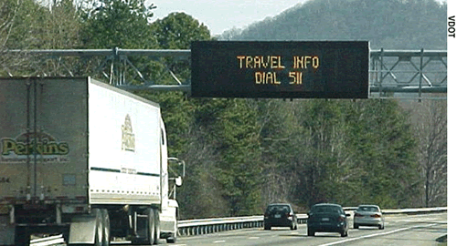 |
| During a recent Web cast on 511 traveler information systems, a presenter recommended that transportation agencies consider marketing their 511 systems using dynamic messages signs, as illustrated in this photo. (Photo Credit: VDOT) |
Matt Burt, principal research scientist with the private enterprise Battelle, summarized a soon-to-be-released FHWA study of the Arizona 511 Model Deployment Project. The Arizona 511 system originated in 1998, and the U.S. Department of Transportation awarded the project a $1 million competitive grant in 2002 to participate in the National 511 Model Deployment. The 511 system that was developed after receipt of the grant features route-based travel information and call transfers to transit systems.
FHWA's study of the Arizona deployment will include data on usage of the system along with information from a user survey, an analysis of a task force study of ways to enhance the system, and a cost analysis. According to Burt, although several system enhancements were incomplete when FHWA performed its research for the study, the reaction from users of the Arizona system was generally positive and call volume has continued to increase.
During his presentation, Burt also discussed some lessons learned from the Arizona experience. For example, he recommended that agencies implementing 511 systems do the following:
Presentations from the 90-minute Web cast are available at www.ntoctalks.com, and a discussion forum at the site features additional questions and comments from the broadcast.
Zia Burleigh 202-366-1896 zia.burleigh@fhwa.dot.gov
To help persons who are blind or visually impaired cross the street safely, the Americans with Disabilities Act (ADA) requires that States and municipalities install detectable warning devices at the boundaries between sidewalks and streets. Truncated domes, which are small, flattened dome surfaces that are inset, glued, or stamped into the surface of the sidewalk, are the standard design requirement for detectable warnings on curb ramps and at flush transitions from sidewalks to street crossings. According to the ADA Accessibility Guidelines for Buildings and Facilities (ADAAG), States and municipalities must install truncated dome surfaces on all new curb ramps and on any projects that alter existing ramps.
In August 2005, the Federal Highway Administration's (FHWA) National Highway Institute (NHI) sponsored a Web conference to provide State and local agencies with information on detectable warnings and truncated dome requirements. Highway professionals and disability specialists from Federal, State, and local agencies located at nearly 70 sites around the country participated in the conference, which featured discussions on ADA's requirements and FHWA's role in assuring compliance with the requirements.
In one presentation, Lois Thibault of the U.S. Access Board, the Federal agency responsible for developing accessibility guidelines under ADA, discussed design standards for detectable warnings between sidewalks and streets. Research has shown that truncated domes provide the most detectable surface, and therefore, they are the only approved detectable warnings in the ADA guidelines. Truncated domes are distinguishable both underfoot and by cane, and the domes are closely spaced to help pedestrians maintain stability. The color of the domes also contrasts with the surrounding pedestrian ramp to provide a cue for persons with low vision about the upcoming transition from the sidewalk to the street. For information and resources regarding detectable warnings, visit www.access-board.gov/adaag/dws/update.htm.
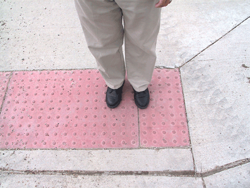 |
| To enhance safety for people who are visually impaired, ADA accessibility guidelines require that truncated dome surfaces, like the one shown here, be installed on new curb ramps and any alterations to existing ramps. |
In another presentation, Lisa MacPhee from the FHWA Office of the Chief Counsel discussed the agency's role in ensuring compliance with ADA requirements for detectable warnings. Within the Federal-aid program, FHWA is responsible for oversight of State and local planning and installation of accessibility features on public rights-of-way. That includes reviewing State and local plans to ensure that they include schedules to install or improve detectable warning devices wherever public agencies provide pedestrian access. FHWA also must ensure that States and municipalities include ADAAG-compliant detectable warnings when undertaking projects that alter existing sidewalks. For FHWA guidance on meeting ADA requirements, visit www.fhwa.dot.gov/environment/bikeped/guidance.htm#Access.
NHI provided closed captioning of the presentations using the U.S. General Services Administration's Federal Relay service, which ensured that individuals with hearing, visual, or speech impairments could participate in the Web conference. NHI also added accessible text-format notes to the online presentations, as recommended by the U.S. Department of Transportation's Disability Resource Center. To download the conference presentations, visit the "Reference" section of the FHWA Detectable Warning Community of Practice Web site at http://knowledge.fhwa.dot.gov/dw. For more information, contact:
Mark Chandler 608-829-7514 mark.chandler@fhwa.dot.gov
Ron McMahon 605-224-7326, ext. 3047 ron.mcmahon@fhwa.dot.gov
Micropiles, small drilled and grouted piles typically less than 300 millimeters (11.8 inches) in diameter, may be used for foundation support beneath road structures, such as bridges, to resist static and dynamic loading conditions. In addition, they can be used as in situ reinforcements for slope and excavation stability. Micropiles offer a viable alternative to conventional piling techniques, particularly in restricted access or low headroom situations. Use of the relatively new micropile technology has grown, but a lack of practical design and construction guidelines has hindered its widespread use.
To train transportation specialists in the use of micropiles, the National Highway Institute (NHI) has teamed with the International Association of Foundation Drilling and the International Society for Micropiles to design a new course, Micropile Design and Construction (#132078A).
The purpose for developing and delivering the course and accompanying Federal Highway Administration (FHWA) manual, Micropiles-Design and Construction Guidelines (FHWA-SA-97-070), is to provide practitioner-oriented technical instruction on when and where to use micropiles. During the course, participants will learn the procedures for designing micropiles for structural support and slope stability. In addition, the course includes discussion of the construction, inspection, and integrity testing of micropiles. Exercises will lead the participants through a feasibility evaluation for micropiles that considers both cost and technical considerations.
After completing the micropiles course, participants will be able to identify potential micropile applications; explain construction constraints; prepare conceptual and basic designs; evaluate contractor-submitted designs; select appropriate specifications and contracting methods and prepare contract documents; and describe construction monitoring and inspection requirements.
To schedule the course, contact the NHI Training Team at 703-235-0534 or visit www.nhi.fhwa.dot.gov/home.aspx. For more information about the course, visit www.nhi.fhwa.dot.gov or contact:
Barry Siel 720-963-3208 barry.siel@fhwa.dot.gov

