U.S. Department of Transportation
Federal Highway Administration
1200 New Jersey Avenue, SE
Washington, DC 20590
202-366-4000
Federal Highway Administration Research and Technology
Coordinating, Developing, and Delivering Highway Transportation Innovations
|
Research & Technology Transporter This newsletter is an archived publication and may contain dated technical, contact, and link information. |
|
| Publication Number: N/A Date: January/February 2006 |
Publication Date: January/February 2006
|
Across the Nation, policymakers are looking for guidance on how to integrate a variety of sidewalk users and motorized and nonmotorized devices into the transportation system. In particular, policymakers want to know more about integration of the Segway® Human Transporter. This information is necessary given the possibility of Segways' greater use, as they are becoming a popular form of transportation for city tours and are carried in stores and shopping malls. To help provide this information, researchers at the Federal Highway Administration's (FHWA) Turner-Fairbank Highway Research Center (TFHRC) in McLean, VA, are conducting a two-part study to learn how Segway riders negotiate typical sidewalk conditions. Started in late 2005, both parts of the research are expected to be completed in summer 2006.
FHWA researchers began the study by selecting 20 participants, including 10 people who had never operated a Segway and 10 experienced riders who own Segways and had ridden them at least once per week for the past year. For the first part of the study, all participants are riding Segways and navigating an obstacle course that simulates a real sidewalk. While the participants ride, the researchers collect information on several aspects of their performance, such as how they adjust their speed when they approach obstacles and pass other sidewalk users. The researchers then will analyze the data to compare the performances of the experienced and novice riders.
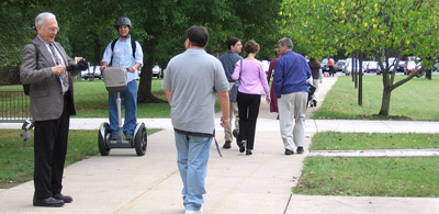 |
| A Segway rider moving among sidewalk users at TFHRC. |
During the second part of the study, which has not yet started, the participants will view a video of a Segway rider navigating sidewalk traffic. FHWA filmed the video at TFHRC, where students from the Thomas Jefferson High School for Science and Technology's mentorship program, along with FHWA employees and contractors, volunteered to walk, bike, and skateboard on a sidewalk along with a Segway rider. A camera mounted on the Segway rider's helmet recorded how the rider interacted with other sidewalk users and reacted to typical situations, such as low and high traffic volumes on the sidewalk, cross traffic, and loitering persons. After the study participants view the video, the researchers will ask them to rate the Segway rider's separation from the other sidewalk users, ability to pass other sidewalk users, and overall riding experience.
The data from this part of the study will be analyzed to determine how experienced and novice Segway riders differ in their perceptions of the sidewalk ridability of a Segway and what factors influence these perceptions. The researchers are hoping that policymakers and engineers may be able to use the study results to better understand the behavior and requirements of Segway riders and develop pedestrian facilities that meet the needs of all users.
This is FHWA's second study of Segway riders at TFHRC. For more information, contact:
Ann Do 202-493-3319 ann.do@fhwa.dot.gov
Planned special events, such as parades, sporting events, and concerts, have the potential to increase travel demand or reduce roadway capacity, thereby causing congestion and delays for motorists. With scheduled times, locations, and durations, these events not only can affect people traveling to and from them but also normal traffic using the roads.
To help organizations better manage the transportation logistics involved with planned events, the Federal Highway Administration's (FHWA) Office of Operations launched a new initiative known as Planned Special Events Traffic Management. As part of the initiative, FHWA sponsored a national travel management conference in 2004 for State and local transportation agencies. In November 2005, the agency presented a plenary session on transportation management at the annual meeting of the International Association of Fairs and Expositions (IAFE) in Las Vegas, NV. The session, entitled "Managing Travel for Planned Special Events: How to Get the Attendees, Exhibitors, and Vendors to the Fair on Time-and Safely," was the first of its kind to be held at IAFE's annual meeting.
Gregory Jones of the FHWA Resource Center's Operations Technical Service Team led the session and discussed resources to help manage event traffic. For example, Jones described FHWA's Managing Travel for Planned Special Events Handbook (FHWA-OP-04-010), which includes practices, strategies, and sample traffic management plans. In addition, he mentioned that beginning in spring 2006 the National Highway Institute will offer the course, Managing Travel for Planned Special Events (#133099).
Also during the session, Frank Kinder of the Colorado Department of Transportation talked about the High Plains Coalition, which is an alliance of transportation agencies in six States. Coalition members exchange information on incidents and events affecting regional travel and post the information on dynamic message signs and broadcast it on the radio.
In addition, Mark Titus, a traffic engineer with the city of Dallas, TX, explained how Dallas developed a traffic plan for Fair Park, the location of the State Fair of Texas© and more than 500 other events each year. The city's plan for getting traffic into the park includes ensuring the proper timing of traffic signals, displaying information on dynamic message signs, and using cameras to monitor traffic.
Kathleen O'Leary, director of marketing for the Wisconsin State Fair Park, discussed traffic strategies for the annual Wisconsin State Fair. The park collaborates with the Milwaukee County Transit System (MCTS) to increase bus service to the park during the 11-day fair and offers a discount on the admission price to fairgoers riding MCTS shuttles from remote parking lots to the fair before noon. The park also coordinates with the Wisconsin Department of Transportation to post information on dynamic message signs on Milwaukee area freeways, indicating the appropriate exits to reach the fairgrounds.
In addition to the IAFE conference, FHWA traffic management experts delivered two presentations in 2005 to members of the International Association of Assembly Managers. For more information on managing traffic for planned special events, visit www.ops.fhwa.dot.gov/program_areas/sp-evnts-mgmt.htm.
Laurel J. Radow 202-366-2855 laurel.radow@fhwa.dot.gov
The National Scenic Byways Program, established under the Intermodal Surface Transportation Efficiency Act of 1991, designates certain roads as National Scenic Byways or All-American Roads based on their archaeological, cultural, historical, natural, recreational, and scenic qualities. Today, there are 126 such designated byways in 44 States, and the Federal Highway Administration (FHWA) provides technical assistance and grants to help States preserve, promote, and manage them.
In October 2005, the FHWA Resource Center organized a national conference to highlight opportunities to sustain and improve scenic byways nationwide. "Rock and Road! 2005," held in Cleveland, OH, drew more than 400 byway coordinators and facilitators from FHWA, State departments of transportation, and local agencies, as well as a delegation from Japan. The 4-day conference included sessions covering many aspects of the byway program, including the economic impact of byways, budget development, signage, Web sites, fundraising, and zoning and land use issues. Other sessions enabled participants to visit byway projects in Ohio, including the Ohio & Erie Canalway, Amish Country Byway, and Ohio River Scenic Byway.
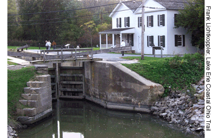 |
| Participants at the 2005 national conference on scenic byways visited the Ohio & Erie Canalway in Peninsula, OH, (shown here) and other byways to learn what it takes to manage these natural, historical, and scenic assets. (Photo credit: Frank Lichtkoppler, Lake Erie Coastal Ohio Trail) |
In a conference session on Federal agency participation, Floyd Thompson of the U.S. Department of Agriculture's Forest Service explained that recreation and byways are economic cornerstones, accounting for 58.5 percent of the $19.1 billion contribution the National Forest System made to the gross domestic product in 2002. Thompson also said that the Partnership Resource Center at www.partnershipresourcecenter.org is a practical tool to help byway organizations build partnerships to manage byways. The site, maintained by the National Forest Foundation and the Forest Service, includes links to resources such as funding, training, and case studies on successful partnerships. Sean Furniss and Nathan Caldwell of the U.S. Fish and Wildlife Service added that their agency maintains 157 wildlife refuges and hatcheries along State and national byways. They explained that refuges benefit byways by providing travelers with opportunities to experience the natural world firsthand. In addition, refuge staff can help byway organizations prepare the corridor management plans required for achieving national designation of byways.
In another presentation, David Dahlquist of the consulting firm Shive-Hattery, Inc., discussed effective signage for byways. According to Dahlquist, good signs have clear and concise messages and up-to-date information, are located so visitors can easily see them, are consistent in design throughout the area, offer flexibility for future updates, and comply with the requirements of the Americans with Disabilities Act. In addition, effective signs follow the principles of universal design, which specify that the design of products and environments should be usable by all people without the need for adaptation or specialized design.
Roger Miles of Miles Media Group outlined principles for developing successful Web sites for byways. According to Miles, nearly 70 percent of U.S. travelers research their vacations online, underscoring the importance of thoughtfully planning a byway's Web presence. An effective Web site, Miles said, should maintain a consumer focus, have substantive content, and serve the needs of visitors by providing travel-planning tools and detailed information. Tools could include interactive maps and directions, information on points of interest and facilities, drive times to sites, and real-time weather and road conditions.
To view conference presentations, visit www.bywaysonline.org/center/events/conferences/2005Cleveland/presentations.html. For more information about the National Scenic Byways Program, visit www.byways.org.
Tashia Clemons 614-280-6841 tashia.clemons@fhwa.dot.gov
To increase the safety and quality of the Nation's roadways, many researchers are searching for ways to improve concrete, one of the most important components of transportation infrastructure. In particular, researchers are looking for ways to optimize the mixing and curing of concrete for higher strength and durability. Concrete technology is rapidly evolving with the modification of the cement itself and the addition of new chemicals for reducing water-to-cement ratios. All these changes, if not correctly managed, can lead to poor performance or even failure of the concrete. One area of interest for many researchers is the process of hydration, or the reaction of water to portland cement concrete. Hydration is the process that causes concrete to harden into usable shapes.
On October 20, 2005, Vanessa Peterson, a University of Maryland postdoctoral fellow at the National Institute of Standards and Technology's Center for Neutron Research (NCNR), presented a seminar at the Federal Highway Administration's (FHWA) Turner-Fairbank Highway Research Center in McLean, VA, entitled "Hydration of Cement: Application of Neutron Scattering." The seminar focused on the use of neutron scattering to explore the sensitivities of cement to water.
During the seminar, Peterson explained that the scattering of particles and waves, such as neutrons, can be used to examine complex systems on a very small scale, at the level of atoms and molecules. The information gathered from neutron scattering can provide researchers with a better understanding of a material's properties. In the case of cement, the properties of neutrons make neutron scattering the ideal tool for researchers to use to better understand how hydration affects the material and learn how to modify the hydration process to change when and how final cement products form.
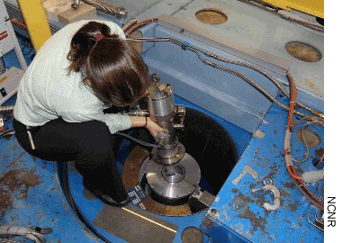 |
| Dr. Vanessa Peterson is shown preparing equipment used to collect data on cement at the National Institute of Standards and Technology's Center for Neutron Research. (Photo credit: NCNR) |
According to Peterson, whose work has been supported by FHWA, researchers at NCNR recently succeeded in using neutron scattering to examine the hydration processes in the primary components of cement. Tricalcium silicate accounts for the bulk of cement's weight and is the source of cement's early strength. Tricalcium silicate is closely tied to early strength development because the compound is far more reactive with water than the other major component of cement, dicalcium silicate, which is similar to tricalcium silicate, but hydrates slower and contributes to long-term strength.
NCNR researchers used a technique called quasi-elastic neutron scattering (QENS) to track the motion of hydrogen atoms in water molecules during each stage of the hydration process. Hydrogen atoms in water can easily move via processes such as vibration, rotation, or translation. The research has shown that as water reacts with cement, the motion of the hydrogen atoms becomes increasingly constrained over time, limited early on to vibrating and rotating in place. In addition, the hydration of tricalcium and dicalcium silicate causes two hydration products to form. When these products form, the hydrogen atoms only can vibrate. The QENS investigations used these different motions of hydrogen to follow the hydration processes in the setting cement. These investigations provided the NCNR researchers with a better understanding of the mechanics of hydration, and they will use the information to help improve certain properties of cement, such as its strength.
After using QENS to separate the states of hydrogen, the researchers used inelastic neutron scattering (INS) to examine the local interactions of atoms and molecules and the formation of hydration products. Although QENS can only determine the total amount of the products formed during hydration, INS can distinguish the various hydration products and was used to examine how much of the hydration product, calcium hydroxide, formed during the setting of the cement.
The NCNR researchers used the complementary QENS and INS tools to establish that dicalcium silicate plays a role in allowing tricalcium silicate to hydrate more effectively, and should increase the early strength of cement. This prediction of an increase in early strength was investigated using 28-day compressive strength testing. The results of the test correlated with the QENS and INS findings, and all combined to show that a cement mixture of approximately 85 percent by weight of tricalcium silicate and 15 percent by weight of dicalcium silicate will have the greatest early strength.
Richard A. Livingston 202-493-3063 dick.livingston@fhwa.dot.gov
Regional transportation planning and investment decisionmaking require collaboration among State and local governments, highway agencies, metropolitan planning organizations, and other stakeholders. Similarly, effective management of a regional transportation system requires coordination among operating agencies across jurisdictions and between transportation and public safety agencies. Linking planning and operations can enhance both activities and optimize the performance of a region's transportation system.
The Federal Highway Administration's (FHWA) Office of Planning and Office of Transportation Management have been collaborating on an initiative to help transportation planners and system operators build stronger links. One part of this initiative is a new Web site, www.plan4operations.dot.gov, which features a library of documents, presentations, reports, and other resources related to transportation planning and operations.
Users of the Web site will find explanations of the importance of linking planning and operations to improve transportation decisionmaking and the overall effectiveness of transportation systems. For example, coordination between planners and operators helps ensure that investment decisions reflect full consideration of all available strategies to meet regional objectives.
One of the resources available on the site is a document titled Getting More By Working Together-Opportunities for Linking Planning and Operations (FHWA-HOP-05-016). Various stages in the transportation planning process offer opportunities for collaboration, including identifying stakeholders and developing goals. Another opportunity is development of a clearinghouse to facilitate access to a region's full range of transportation data for both planning and operations. This approach is illustrated in the Portland, OR, metropolitan area, where several agencies share operations data and use it in planning specific projects.
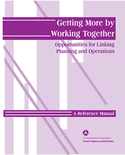 |
| The document shown here, Getting More By Working Together-Opportunities for Linking Planning and Operations, is one of the resources available on FHWA's new Web site www.plan4operations.dot.gov. |
Transportation planners and operators also can collaborate on performance measurement, the process of assessing progress toward goals. Working together, planners and operators at the Washington State Department of Transportation, for example, developed performance measures for traffic congestion that focus on travel reliability rather than on traditional measures such as average travel speeds.
Harlan Miller 202-366-0847 harlan.miller@fhwa.dot.gov
Wayne Berman 202-366-4069 wayne.berman@fhwa.dot.gov
The city of Atlanta, GA, and the surrounding metropolitan area have a growing congestion problem. According to the Texas Transportation Institute's 2005 Urban Mobility Report, Atlanta had the 5th worst congestion in the Nation in 2003, up from 15th in 1996. In addition, daily travel on Atlanta's freeways increased nearly 20 percent during those same years. The money wasted in Atlanta from lost time and fuel due to congestion also is rising, with congestion costing each peak period traveler more than $1,100 in 2003, up from $919 in 1996. This congestion also is harmful to Atlanta's air quality. According to the American Lung Association®, the metropolitan Atlanta area ranks 9th in the country for having the worst year-round particulate pollution, one of the major mobile source pollutants and a probable carcinogen.
With statistics and challenges such as these, it is no surprise that Atlanta commuters and transportation officials are looking for new ways to reduce congestion, improve air quality, and save time, gas, and money. Many Atlanta commuters, for example, are participating in The Clean Air Campaign's® Cash for Commuters program, which provides motorists who typically drive alone to work with a cash incentive to start using an alternative mode of transportation. Commuters can earn $3 per day, with a limit of $180 over 3 months, for making the switch from driving alone to carpooling, telecommuting, using transit, walking, or bicycling. Started in summer 2004 with sup-port from the Federal Highway Administration (FHWA), the Cash for Commuters program was originally intended to last 1 year. The program was more popular than expected, however, and was extended through the end of 2005.
| The logo for the Cash for Commuters program. (Photo credit: The Clean Air Campaign®) |
Research and statistics confirm the growing popularity of Cash for Commuters. Prior to the recent significant increase in gasoline prices, The Clean Air Campaign received approximately 500 applications per month to participate in the program. In September 2005, after the price increases, approximately 2,500 commuters applied to participate. In addition, the campaign's Web site saw a 300-percent increase in visitors, and the Atlanta region's instant online commuter ridematching service received 288 new registrations in just 2 days, more than double the previous average for an entire month.
Research also has demonstrated the effectiveness of Cash for Commuters at persuading motorist who use single occupancy vehicles to switch to alternative modes of transportation and to continue using alternative modes even after receiving the maximum cash incentive provided by the program. According to a 2004 survey by the Center for Transportation and the Environment, on behalf of the Georgia Department of Transportation, 74 percent of Cash for Commuters participants continued to use an alternative mode of transportation for 3 to 6 months after completing the program. In addition, 64 percent continued to do so for 9 months to 1 year after exiting the program.
Efforts similar to the Cash for Commuters programs exist in other parts of the country, but few offer cash incentives. In Contra Costa County, CA, for example, solo drivers are eligible for one free $60 transit pass, as an incentive to try transit. New carpoolers, vanpoolers, and schoolpoolers-parents who carpool when transporting their children to and from school-also can get gas cards, bus passes, and cash bonuses.
The impact of Cash for Commuters on air pollution is difficult to quantify, but it likely is having a positive impact. According to Max Azizi of FHWA's Georgia Division Office, "The amount of benefit depends on the popularity and the size of the program. Atlanta had more than 20,000 people sign up for various commuter rewards programs in 2005."
For more information, call 1-877-CLEANAIR, visit www.cleanaircampaign.org, or contact:
Daniel Fodera 404-562-3913 daniel.fodera@fhwa.dot.gov
Andrew Edwards 404-562-3659 andrew.edwards@fhwa.dot.gov
Intelligent transportation systems (ITS) improve safety and relieve congestion through the application of traffic management, communications, and information technologies. Although agencies across the Nation are deploying a variety of ITS technologies, more information is needed on the most effective ways to use these smart technologies to enhance the performance of the transportation system.
To demonstrate how ITS can improve transportation operations, in March 2003 the Federal Highway Administration (FHWA) provided a $10 million grant to the Florida Department of Transportation (FDOT) to conduct an ITS model deployment called iFlorida. As part of the project, FDOT recently launched a statewide 511 telephone system that enables all Florida drivers to dial 511 for real-time information on traffic conditions, construction updates, lane closures, and severe weather alerts on interstates and Florida's Turnpike. FDOT also expanded the existing 511 system in Central Florida to provide traffic information on 15 regional highways in addition to the information provided for the past 3 years on Interstate 4 (I-4).
FHWA Acting Administrator J. Richard Capka joined FDOT Secretary Denver Stutler, Jr., and other Florida officials at the FDOT Regional Traffic Management Center in Orlando for the November 2005 unveiling of the expanded 511 system. "By helping drivers steer clear of trouble, we're cutting the gridlock that frustrates our lives, wastes time and fuel, and stifles economic opportunity," said Capka, who also explained that the 511 system will serve as an invaluable tool during hurricane season when the most current highway information is especially crucial.
 |
| A bumper sticker advertises FDOT's expanded 511 system, which provides Florida drivers with real-time traffic information by phone at 511 and on the Web at www.fl511.com. (Photo credit: FDOT) |
At the Orlando event, FDOT District 5 Secretary George Gilhooley demonstrated the 511 system, including expanded features available to drivers in Central Florida. For example, drivers there can now plan their travel by calling 511 for current congestion reports. They also can request traffic information by city, county, or specific roadway and receive a summary of drive times on all roads in the area. The new Web site, www.fl511.com, delivers all the information provided on the 511 phone system and features enhanced Central Florida content, including travel times, roadway cameras, construction updates, and severe weather reports for I-4 and other major roadways.
In addition to the FHWA grant, iFlorida is funded by more than $10.95 million in matching State, local, and private sector funds. Over the next 2 years, FHWA will work with FDOT to evaluate the effectiveness of the system and create a model for use by other States and jurisdictions across the country.
Chung Tran 850-942-9650 ext. 3041 chung.tran@fhwa.dot.gov
Lokesh Hebbani 850-942-9650 ext. 3040 lokesh.hebbani@fhwa.dot.gov
Solving the transportation challenges faced in the 21st century will require a significant cultural shift in the operation and management of transportation systems. Operationally, the cultural change requires a cross-jurisdictional and multiagency perspective that anticipates user needs, focuses on customers, and is regionally based. From a planning standpoint, the cultural shift means ensuring that operations are increasingly considered in regional planning and investment decisions.
To help improve the long-term planning and management of the transportation system, representatives from the Association of Metropolitan Planning Organizations, Institute of Transportation Engineers, and Federal Highway Administration developed a new National Highway Institute course, Advancing Transportation Systems Management and Operations (#133098).
The goal of the 1-day course is to provide participants with an understanding of transportation systems management and operations (TSM&O) in a regional context and to show why such knowledge is needed to overcome the Nation's transportation challenges. The course also addresses how transportation specialists can improve TSM&O in their own communities by enacting a cultural shift in operations thinking.
The course highlights a five-part framework for collaboration. After completing the course, participants will be able to state the importance of a regional perspective in TSM&O; describe the cultural shift needed among operators, planners, and decisionmakers to successfully affect TSM&O; and identify opportunities to better link planning and operations. In addition, participants will be able to describe a framework for advancing TSM&O.
The course is intended for anyone with an interest in transportation planning and operations, including practitioners responsible for making decisions on transportation management and operations within their organizations. There are no prerequisites for participation; however, familiarity with regional transportation planning, operations, and intelligent transportation systems is helpful. For more information visit www.nhi.fhwa.dot.gov or contact:
Wayne Berman 202-366-4069 wayne.berman@fhwa.dot.gov

