U.S. Department of Transportation
Federal Highway Administration
1200 New Jersey Avenue, SE
Washington, DC 20590
202-366-4000
Federal Highway Administration Research and Technology
Coordinating, Developing, and Delivering Highway Transportation Innovations
|
Research & Technology Transporter This newsletter is an archived publication and may contain dated technical, contact, and link information. |
|
| Publication Number: N/A Date: June 2006 |
Publication Date: June 2006
|
The Federal Highway Administration (FHWA) has long provided a wealth of information on the Agency's research and technology (R&T) activities through a network of Web sites. Because no central access point existed on the Internet for technical information or updates on R&T activities, however, it was sometimes challenging to find specific information in a timely and efficient manner.
To make it quicker and easier to connect to R&T information, FHWA has launched a new "Corporate Research and Technology" Web site at www.fhwa.dot.gov/crt/. The site provides an umbrella portal for stakeholders seeking direct access to updates on FHWA's R&T activities and initiatives. The site is an outgrowth of the Corporate Master Plan for Research and Deployment of Technology & Innovation (FHWA-RD-03-077), which calls for FHWA to communicate its R&T program and projects effectively to stakeholders "consistently and with the appropriate level of detail."
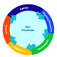 |
| FHWA's new "Corporate Research and Technology" Web site is organized around the five phases in the life cycle shown here. |
To organize information, the site uses an "innovation life cycle" concept with five phases: agenda, ongoing research, technologies, deployment, and impacts. The life cycle concept illustrates that highway R&T deployment is neither linear nor finite. Instead, each phase supports another phase. When site visitors click on a phase on the life cycle illustration located in the upper right corner of each Web page, they are transported to information corresponding to that phase.
The "Agenda" phase, for example, outlines the R&T agenda-setting process. This section also includes links to information about and results from recent workshops on advanced research. The information in this section provides an important source of information for FHWA as it establishes the form and content of its Advanced Research Program.
The "Ongoing Research" phase provides a summary of FHWA's research portfolio and links to other sites with information on highway research. The "Technologies" phase highlights the priority, market-ready technologies and innovations that FHWA is encouraging transportation agencies to deploy. The "Deployment" phase introduces a new framework for tracking the progress of technology deployment. The "Impacts" phase provides examples of how FHWA evaluates R&T benefits. By clicking on the middle of the life cycle, users can access examples of program roadmaps and information about opportunities to participate in planning activities.
FHWA designed the site to enable technical experts and the public to participate in the development, deployment, and evaluation of its R&T projects and programs. The "Get Involved" area provides portals that visitors can use to submit ideas or comment on technical documents. The Web Site also provides R&T news, examples of program roadmaps, and information about the latest FHWA priority, market-ready technologies and innovations.
Visitors are encouraged to provide suggestions about the Web site through the "We Want Your Feedback" section. FHWA will respond to comments and suggestions in a timely manner.
John Munro 202-493-3368 john.munroe@fhwa.dot.gov
The three fundamental principles of environmental justice are to avoid, minimize, or mitigate disproportionately high and adverse human health and environmental effects, including social and economic effects, on minority and low-income populations; to ensure the full and fair participation by all potentially affected communities in the transportation decisionmaking process; and to prevent the denial of, reduction in, or significant delay in the receipt of benefits by minority and low-income populations. In addition, Title VI of the Civil Rights Act of 1964 prohibits discrimination on the basis of race, color, and national origin in programs and activities receiving Federal financial assistance.
The U.S. Department of Transportation (USDOT) is committed to integrating the principles of environmental justice and Title VI into all of its Federal-aid programs and projects. To accomplish this objective, USDOT ensures these ideas are part of every transportation decision. To help transportation practitioners learn about these concepts, the Federal Highway Administration's National Highway Institute (NHI) offers the course Fundamentals of Title VI/Environmental Justice (FHWA-NHI-142042).
The course provides participants with a variety of approaches and tools for ensuring that environmental justice is incorporated into Federal-aid programs and transportation projects. After completing the course, participants will be able to:
Although the course has been offered since 2001, NHI recently updated it to include more recent examples that reflect advances at the State, regional, and local levels. During the course, NHI uses case studies to familiarize participants with effective ways to address environmental justice concerns during transportation decisionmaking. The case studies also provide participants with an opportunity to discuss effective environmental justice practices; learn about resources for handling environmental justice issues; and practice their organization and presentation skills.
The course targets staff from transportation or transit agencies; planners and consultants who interact with minority and low-income communities; professionals from State and local agencies that provide community services; and elected officials and their representatives. There are no prerequisites.
To register for the course, contact the NHI Training Team at 703-235-0534 or nhitraining@fhwa.dot.gov. For more information, visit www.nhi.fhwa.dot.gov/ or contact:
David Kuehn 202-366-6072 david.kuehn@fhwa.dot.gov
Weather can affect highway operations on any day and on any road. To improve safety and mobility during adverse weather, transportation practitioners need to know not only how different types of weather will affect roadways but also what types of strategies and tools they can apply to avoid or minimize those effects.
To provide practitioners with information on the various resources and techniques available to deal with adverse weather, the Federal Highway Administration's (FHWA) National Highway Institute (NHI) is offering the course Principles and Tools for Road Weather Management (FHWA-NHI-137030).
The course begins with an overview of road weather problems and their impacts, and provides a lesson in basic meteorology. In addition, participants review common methods to deal with weather-related problems, such as maintenance, traveler information, emergency management strategies, and the application of Road Weather Information Systems and other decision support tools. After completing the course, participants will be able to:
To help ensure that participants understand the lessons, each topic or session includes one or more exercises. At the end of the course, participants can take an additional quiz to receive 0.6 credits through the International Association for Continuing Education and Training.
The course targets professionals engaged in highway maintenance, operations, traffic management, emergency management, and highway safety. The course will be particularly beneficial to practitioners engaged in implementing solutions to roadway problems, staff from State and local transportation or public works agencies, mid-level managers who direct their agency's resources, and FHWA personnel. There are no prerequisites.
To learn more about participating in the course or for scheduling information, visit www.nhi.fhwa.dot.gov. For answers to technical questions, contact:
Roemer Alfelor 202-366-9242 roemer.alfelor@fhwa.dot.gov
Transportation professionals use traffic simulation models to design, evaluate, and optimize existing and planned transportation facilities and systems. With today's congested and complex transportation facilities, it is critical that traffic simulation models be accurate and trustworthy so that sound transportation decisions can be made.
To help address this issue, the Federal Highway Administration (FHWA) launched the Traffic Analysis Tools Program to develop new and improved analysis methods and facilitate deployment of existing tools. As part of this effort, FHWA initiated the Next Generation Simulation (NGSIM) program to improve the quality of traffic simulation tools and promote the use of simulation research. Under the NGSIM program, researchers are developing driver behavior algorithms, which are mathematical models for replicating driver behavior, to support traffic simulation research. The Freeway Lane Selection algorithm is now complete and available on the NGSIM Web site, www.ngsim.fhwa.dot.gov, under the Core Algorithms link.
The Freeway Lane Selection algorithm enables transportation professionals to more accurately model lane-changing behavior on freeways. Existing traffic simulation models typically simulate the behavior of drivers changing lanes only to the immediate left or right lane, but this new algorithm incorporates the "target lane" concept, in which drivers target the "best" lane on the entire freeway and may make multiple lane changes on their way to the target lane. This behavior is especially prevalent on freeways with high occupancy vehicle (HOV) lanes.
Three additional NGSIM algorithms also are under development. The Cooperative/Forced Freeway Merging algorithm will incorporate voluntary and involuntary driver maneuvers at congested merging and weaving areas. The Arterial Lane Selection algorithm will incorporate the target lane concept on arterial facilities while considering tactical lane-changing behaviors and aggressive overtaking behaviors. The Oversaturated Freeway Flow algorithm will focus on car-following and lane-changing behaviors on oversaturated freeways.
In addition to developing algorithms, researchers in the NGSIM program collected detailed vehicle trajectory datasets, which include information recorded at 0.1-second intervals on the precise location of nearly 100 percent of vehicles on 0.5- to 1-kilometer (0.3- to 0.6-mile) sections of roadway. So far, researchers have collected one arterial and three freeway datasets, which also are available at the NGSIM Web site. These datasets provide researchers with information for traffic flow, operations, and simulation research.
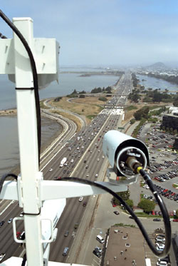 |
| A digital camera mounted on top of a building that overlooks a highway is recording vehicle trajectory datasets for FHWA's NGSIM program. |
FHWA is making all the algorithms and datasets available free on the NGSIM Web site so that members of the commercial modeling market can incorporate the data into their own models. FHWA is working closely with stakeholder groups to ensure that the algorithms are well developed, validated, and accepted by the commercial market and overall transportation community. The ultimate benefit of the NGSIM program will be high-quality, trustworthy traffic simulation models, which will lead to better decisions on transportation investments.
James Colyar 202-493-3282 james.colyar@fhwa.dot.gov
John Halkias 202-366-2183 john.halkias@fhwa.dot.gov
Poor signal timing contributes to traffic delay in many metropolitan areas. To help solve this problem, researchers at the Federal Highway Administration (FHWA) developed adaptive control software (ACS), which adjusts signal timing to accommodate changing traffic patterns. Sensors record the characteristics of traffic approaching a signal, and then ACS, applying mathematical and predictive algorithms, adapts the signal timing to optimize traffic flow. Although ACS systems can reduce congestion and are designed to handle the most volatile traffic conditions, their cost—$10,000 to $40,000 per intersection—puts them beyond the reach of many communities.
To solve this problem, FHWA's Turner-Fairbank Highway Research Center recently conducted field tests of ACS Lite, a reduced-scale version of ACS that offers a lower cost traffic control system. The tests showed improved traffic flow on the roadway sections where the software was used.
ACS Lite can be used with new traffic signals or to retrofit existing signals. Although ACS is designed to handle rapidly changing traffic conditions at a signalized intersection on a second-by-second basis, ACS Lite is designed for closed-loop systems, which connect a series of traffic signals to each other and to an onstreet master controller, providing cycle-by-cycle control. The initial cost to install ACS Lite on an existing closed-loop system covering multiple intersections is significantly cheaper than installing full ACS systems at individual intersections.
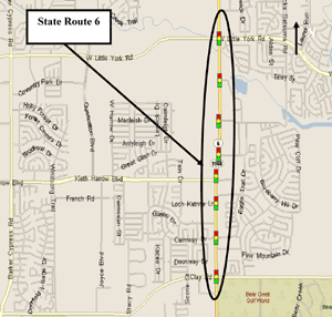 |
| This map shows the location of an ACS Lite field test on State Route 6 in Houston, TX. |
FHWA conducted the first test deployment of ACS Lite in the Columbus, OH, suburb of Gahanna, where the technology was installed on a closed-loop system connecting nine signalized intersections along a principal arterial. The resulting data indicated that motorists' savings on fuel and travel delays totaled $88,500 per year as a result of the software. A similar field test on eight signalized intersections along State Route 6 in Houston, TX, showed that using ACS Lite saved motorists $578,000 per year. Additional field tests are underway in Bradenton, FL, and El Cajon, CA.
In addition to providing a money-saving option for jurisdictions with closed-loop signal systems, ACS Lite can be used by communities that operate traffic signals using small- to medium-size centralized control systems but lack the funds to install a full ACS system. Besides fewer travel delays and lower fuel consumption, the benefits of ACS Lite include reduced emissions of hydrocarbons and carbon monoxide due to decreased traffic congestion, and lower operating and maintenance costs for transportation agencies.
ACS Lite is available from companies that supply traffic signal systems. For more information, visit www.tfhrc.gov/its/pubs/acsl/index.htm.
Raj Ghaman 202-493-3270 raj.ghaman@fhwa.dot.gov
Historically, traffic engineers have treated transportation network planning and operations analysis as separate functions. To properly address both planning and operations issues for the same transportation network, however, engineers increasingly need tools that unify planning and operations analysis in a single, dynamic format.
DYNASMART-P is a state-of-the-art planning tool that engineers can use to address complex transportation planning and operations issues simultaneously. Researchers at the University of Maryland developed the software under the Federal Highway Administration's (FHWA) Dynamic Traffic Assignment research project. Version 1.0 of DYNASMART-P is available from the Center for Microcomputers in Transportation (McTransTM) at http://mctrans.ce.ufl.edu/featured/dynasmart/index.htm. In addition, FHWA recently completed testing of an updated version of the software, which will be available from McTrans in June 2006. The new version reduces the computer memory required for using the software and includes new features, such as a pricing element that enables planners to specify a toll that depends on the time of day.
 |
| The logo for DYNASMART-P is shown here. DYNASMART-P overcomes the limitations of traditional static assignment and simulation models and helps engineers model the evolution of traffic flows. |
DYNASMART-P supports planning and operations decisions through the application of simulation-based dynamic traffic assignments. This tool combines dynamic network assignment models, used primarily with demand forecasting procedures for planning applications, and traffic simulation models, used mainly for traffic operations studies. With DYNASMART-P, engineers can model the evolution of traffic flows that result from individual drivers seeking the best routes to their destinations. The software is designed to overcome many of the limitations of current static planning tools, such as the types of measures that can be evaluated.
Potential applications of DYNASMART-P include assessing the impacts of alternate traffic operations and control strategies, and evaluating strategies for work zone, incident, and special event management. Engineers also can use the software to assess the impacts of intelligent transportation system technologies, such as dynamic message signs, ramp meters, and invehicle guidance systems, on the transportation network. In addition, DYNASMART-P can evaluate congestion-pricing schemes for toll roads and produce traffic operations data for air quality analyses.
Transportation planners and engineers already have used DYNASMART-P in several successful applications, including development of traffic management strategies for major highway reconstruction projects in Zwolle, a city in the Netherlands. In addition, the software was used in conjunction with CORSIM, a comprehensive traffic corridor simulation model, in El Paso, TX, to evaluate downtown traffic and environmental impacts of one- and two-way traffic flow reconfigurations.
DYNASMART-P is one of FHWA's 24 priority, market-ready technologies and innovations the Agency is actively encouraging deployment. For a fact sheet on DYNASMART-P, visit www.fhwa.dot.gov/tempcrt/lifecycle/dynasmart.cfm.
For more information on DYNASMART-P, contact:
Henry Lieu 202-493-3273 henry.lieu@fhwa.dot.gov
Hale Township, IA, is divided by the Wapsipinicon River. In 1879, the three-span Zenas King patent bowstring bridge was built over the Wapsipinicon to provide year-round access to all of the township. This bridge, known today as the Hale Bridge, encouraged economic development by providing safe and reliable access to the rail line and depot in Hale Village. Over the years, however, the bridge deteriorated, and in 1997 it was closed to traffic and later replaced with a new bridge. Despite the bridge closing, the public remained interested in the bridge's future. Local groups launched a campaign to save the bridge, and the structure was listed in the National Register of Historic Places.
In 2003, Iowa officials relocated the Hale Bridge from its existing piers to a staging area, where it was repaired, strengthened, and repainted. In addition, officials prepared a new site for the bridge 24 kilometers (15 miles) away in Wapsipinicon State Park, where the bridge could be used as a river crossing along a 5-kilometer (3-mile) recreational trail. In March 2006, the Iowa Army National Guard used two Chinook helicopters to fly the bridge's three wrought-iron spans to the new site. The unique flight was the result of 4 years of planning and was made possible with the help of Transportation Enhancement funds from the Federal Highway Administration (FHWA).
Lasting only 90 minutes, the challenging move was completed without incident. To enable the public to watch the relocation, Iowa officials ran a shuttle service from Anamosa, IA, to the new site. Thousands of spectators turned out to see the "flying bridge," including 700 elementary schoolchildren. In addition, Iowa Public Television featured the flight on its channels, and the History Channel will show the relocation in an episode of its series Mega Movers.
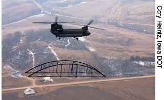 |
| An Iowa Army National Guard helicopter is shown transporting part of the historic Hale Bridge to its new location. (Photo credit: Cory Heintz, Iowa DOT) |
To prepare the bridge for transport, Guard members attached a system of cables and bracing to each of the three spans. This stabilized the bowstring trusses and provided attachment points for the lifting cables used by the helicopters. The weight of the longest span was within 181 kilograms (400 pounds) of the 9,072-kilogram (20,000-pound) lifting capacity of the Chinooks. Preparations also included construction of new abutments and piers to support the bridge at its new location.
Prior to the anticipated opening of the bridge in fall 2006, the project sponsors will construct a timber deck, build the bridge approaches, and landscape both sides of the river. The bridge at its new location will be renominated to the National Register of Historic Places.
In addition to FHWA, several other agencies provided funding for the Hale Bridge rehabilitation and relocation. The Jones County Historic Preservation Commission, for example, received $445,000 in grants from the State Historical Society of Iowa, Iowa Department of Transportation (Iowa DOT), Iowa Department of Economic Development, Iowa Department of Natural Resources, East Central Iowa Council of Governments, and individuals and groups within and outside of Jones County.
To watch a video of the flight, visit www.desmoinesregister.com/apps/pbcs.dll/article?AID=/20060308/COMM01/303080006.
Janice Thompson 515-233-7324 janice.thompson@fhwa.dot.gov
One of the Federal Highway Administration's (FHWA) highest priorities is developing and promoting stronger, more durable construction materials for use when replacing or rehabilitating deteriorating bridges. One such material is ultra-high performance concrete (UHPC), which was developed in France in the 1990s with the goal of improving the quality, durability, and cost efficiency of bridges. Although UHPC has seen limited use in the United States, it has been undergoing study at FHWA's Turner-Fairbank Highway Research Center.
As a result of FHWA's research, the first highway bridge in North America built with UHPC has been completed in Wapello County, IA. The Mars Hill Bridge, which replaced a severely deteriorated 73-year-old truss bridge, opened to traffic in May 2006. The bridge is the culmination of a 5-year collaboration involving FHWA, the Iowa Department of Transportation (Iowa DOT), Wapello County Secondary Road Department, Iowa State University (ISU) Bridge Engineering Center, and private industry.
The new UHPC bridge features a single-span, three-beam cross section. Before the bridge was built, researchers at the ISU Structural Engineering Research Laboratory conducted tests on a UHPC beam of the type intended for use on the bridge. The purpose was to verify the beam's shear strength, or strength against failure when a component splits into two parts that slide past each other, and flexural, or bending, strength. In the shear test, the beam carried an applied load of 2,860 kilonewtons (643 kips) before failure. In the flexure test, the first cracks appeared as expected at an applied load of 1,140 kilonewtons (256 kips).
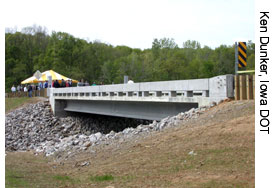 |
| The Mars Hill Bridge in Wapello County, IA, shown here, is the first bridge built in North America with UHPC, a material designed to produce stronger, more durable bridges. (Photo credit: Ken Dunker, Iowa DOT) |
The bridge also contains three 33-meter (110-foot) prestressed girders. In addition to the innovative aspects inherent to UHPC, these girders are innovative because they do not contain any mild steel reinforcing bars. This is possible because the UHPC has sufficient tensile capacity to carry the shear forces in the girders.
Stronger, more durable bridges and faster construction are the anticipated benefits from using UHPC for bridge construction. The material includes steel fiber reinforcement, which increases durability and tensile strength, or the strength against breakage when a material is pulled or stretched. Instead of the coarse aggregate found in standard concrete, UHPC contains fine aggregates that make the material denser and less permeable. The cost of UHPC is higher than for standard concrete, but increased structural efficiency of the girders due to longer spans and/or wider spacing and reduced girder fabrication costs are possible. Another benefit is that precast bridge elements built with UHPC are lighter and easier to transport to the job site and can be put into place faster during construction, saving time and labor costs.
FHWA provided partial funding for the Mars Hill Bridge through its Innovative Bridge Research and Construction Program, which helps State, county, and local transportation agencies incorporate innovative materials and technologies into their bridge projects. Now that the bridge is in place, the ISU Bridge Engineering Center will conduct a 2-year monitoring program to document the performance of the UHPC beams.
Benjamin Graybeal 202-493-3122 benjamin.graybeal@fhwa.dot.gov

