U.S. Department of Transportation
Federal Highway Administration
1200 New Jersey Avenue, SE
Washington, DC 20590
202-366-4000
Federal Highway Administration Research and Technology
Coordinating, Developing, and Delivering Highway Transportation Innovations
|
Research & Technology Transporter This newsletter is an archived publication and may contain dated technical, contact, and link information. |
|
| Publication Number: N/A Date: May 1998 |
Publication Date: May 1998
|
Much of the data generated by Intelligent Transportation Systems (ITS) can be of great value beyond their immediate use in real-time control strategies. However, unless ITS operators have made special provisions, data from system surveillance equipment are typically not stored for future use. Furthermore, the National ITS Architecture currently has no specification for a data archival process.
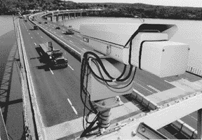
Photo: ITS-generated data from traffic detectors like this one should be saved and used for multiple purposes.
[photo curtesy NY State Thruway Authority.]
Data needs of many stakeholder groups have been identified in several past studies. In particular, the ITS as a Data Resource Workshop held in January 1998 in Washington, DC, substantiated stakeholder needs and began the process of matching ITS-generated data with those needs. Those interested included State and local transportation planners, ITS operators and engineers, transit operators, freight and intermodal planners, safety analysts, maintenance personnel, researchers, and others.
For the most part, data generated by ITS is similar to data collected by traditional means (e.g., traffic counts) except ITS-related data is collected continuously and at a very detailed level. Accordingly, a wide range of stakeholder functions can be supported with data from ITS. For example, roadway surveillance data can be used in many stakeholder applications, including development and calibration of travel demand forecasting and simulation models, congestion monitoring, transit route and schedule planning, intermodal facilities planning, and air quality modeling.
Because of the wide range of support among stakeholders represented at the ITS as a Data Resource Workshop, it has been determined that there is a need for a new user service to be included in the National ITS Architecture: the Archived Data User Service. A preliminary requirements document which reflects the diversity of the many data users has been prepared by Richard Margiotta of SAIC for the Office of Highway Information Management. It serves as an initial step toward integrating data archiving into the architecture and standards development process underway.
Successful implementation will require resolution of many difficult institutional and technical issues, including development, operation, and maintenance costs; system access; ownership; data quality; data management; data and communications standards; privacy concerns; data analysis; coordination with other data collection efforts; liability; confidentiality of privately collected data; incremental and uncoordinated ITS deployments; retrofitting vs. new development of systems; data flows not defined by the National ITS Architecture; conformance with metric conversion standards; and training and outreach. Further outreach efforts are anticipated to ensure that a diverse stakeholder community is involved in this important initiative.
- Ralph Gillmann, (202) 366-5042, ralph.gillmann@fhwa.dot.gov
https://www.fhwa.dot.gov/ohim/ohimprod.htm
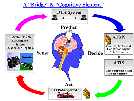
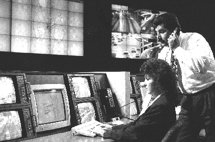
To address complex traffic control and management issues in the dynamic ITS environment and to assess the ITS impact, FHWA has been exploring Dynamic Traffic Assignment (DTA) systems. In fact, in August 1994, FHWA in collaboration with Oak Ridge National Laboratory (ORNL) started developing a deployable real-time DTA system. The system will be able to serve as an effective integrator between the Advanced Traffic Management System (ATMS) and the Advanced Traveler Information System (ATIS). It will be deployable in real time in a congested network in which recurrent and non-recurrent congestion may occur. A DTA system is defined as a system with the following broad functional capabilities:
Thus, the DTA system forms a bridge among real-time traffic surveillance systems, other ATMS support systems, and ATIS. It can be considered as a principal cognitive element of ITS.
Two parallel DTA development contracts were awarded to Massachusetts Institute of Technology and the University of Texas at Austin, respectively, in October 1995. Each team is developing a prototype of the DTA system demonstrating its potential for real-time application capability. So far, the teams have completed functional requirement analysis, conceptual system design and framework, analytical development for the prototype system, and DTA software development. Intensive testing of each prototype system is currently underway. The two prototype systems will be delivered to ORNL and FHWA in June 1998 for further evaluation. A single system will be produced by combining the best features of both teams' approaches and further refining the end product for field experiments.
To receive feedback from researchers and ITS practitioners in the field, the two prototype systems are being demonstrated at the upcoming ITS America 8th Annual Meeting from May 4 to 7, in Detroit, Michigan. A web site (http://www-cta.ornl.gov/cta/research/dta/) was established to facilitate dissemination of the technical reports from this study. The web page covers: (1) background; (2) developmental process and planned schedule; (3) participating R&D teams; (4) technical approaches; (5) progress summary; (6) laboratory evaluation and system integration; and (7) reports, papers, and presentations.
- Henry C. Lieu, (202) 493-3273, henry.lieu@fhwa.dot.gov
According to the National Personal Transportation Survey (NPTS), bicycling and walking account for nearly 6.4 percent of all trips made, and nearly $1 billion has been spent on enhancing and providing facilities for these two modes. In the last fiscal year alone, $238 million was spent on independent bicycle and pedestrian projects in the United States. Despite these figures, transportation modeling is limited to motorized modes, and as a result, bicyclists and pedestrians are marginalized to the degree that they do not even show up in the plans and considerations for a transportation system.
An FHWA report, Bicycle/Pedestrian Trip Generation Workshop: Summary (FHWA-RD-97-141), presents the summary of a workshop that FHWA sponsored in November 1996 in Washington, DC. The workshop was held as a forum for obtaining input from a group of leading non-motorized transportation modelers on various research methods for promoting walking and bicycling as other modes of transportation. FHWA has made a commitment to increase the current percentage of total trips made by bicycling and walking and to reduce the number of bicyclists and pedestrians killed or injured in traffic crashes.
Copies of the report are available from the R&T Report Center by phone (301-577-0906) or fax (301-577-1421). The report should be of interest to State and local bicycle and pedestrian coordinators, transportation planners, and engineers involved in designing pedestrian and bicycle facilities within the highway system.
- Ann Do, (202) 493-3319, ann.do@fhwa.dot.gov
In 1996 in the United States, 5,412 pedestrians and 761 bicyclists were killed and an estimated total of 141,000 were injured as a result of collisions with motor vehicles. Before State and local transportation engineers and planners, pedestrian/bicycle coordinators, health and education officials, and law enforcement can improve non-motorist safety, they must know how pedestrian- and bicycle-motor vehicle crashes occur. A thorough understanding of the problem can help communities develop countermeasures to lessen conflicts and resulting crashes.
Two FHWA publications, Bicycle Crash Types: A 1990's Informational Guide (FHWA-RD-96-104) and Pedestrian Crash Types: A 1990's Informational Guide (FHWA-RD-96-163), are now available. They are simple informational guides to the most frequently occurring types of bicycle- and pedestrian-motor vehicle crashes. The guides are based on detailed examinations of the actions preceding the crashes. A sample of 5,000 pedestrian and 3,000 bicycle crashes was taken from California, Florida, Maryland, Minnesota, North Carolina, and Utah. The guides identify where engineering, educational, and regulatory countermeasures might be effectively implemented to reduce the frequency of the crashes.
Copies of these handsome, two-color publications are available from FHWA's R&T Report Center by calling (301) 577-0906 or the National Bicycle and Pedestrian Clearinghouse by calling (202) 463-8405. Information on issues and research relating to improving pedestrian and bicyclist safety are also available on our new web page: www.tfhrc.gov/pedbike/pedbike.htm. Check it out!
- Carol Tan Esse, (202) 493-3315, carol.tan.esse@fhwa.dot.gov
A crash test was recently conducted on a buried-in-backslope terminal, which is a type of treatment for a W-beam guardrail. The buried-in-backslope terminal had a 6:1 slope and a vee ditch in front of it. The approach guardrail and the terminal section had 150- by 200-mm routed wood blockouts mounted on steel posts. A steel rub rail was added to prevent the wheels and bumpers of the test vehicle from snagging on the posts.
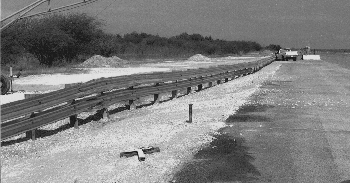
Photo: Buried-in-backslope guardrail terminal after crash test.
A 2000-kg pickup truck impacted the terminal at the eighth post at 97 km/h and an impact angle of 25 degrees. The pickup truck was redirected and remained upright. The vehicle subsequently came to rest 66 m from the point of impact and adjacent to the rail (as shown in the photo above). The W-beam rail was attached to a steel post that was buried in the backslope. This steel post was used instead of a concrete end anchor block because it saved installation costs.
- Charles McDevitt, (202) 493-3313, charlie.mcdevitt@fhwa.dot.gov
Since the repeal of the NMSL, many States such as ________, have raised their speed limit. A 55 mi/h (89 km/h) National Maximum Speed Limit (NMSL) was enacted by Congress in early 1974 as a temporary energy conservation measure. When Congress noted the resulting reduction in highway fatalities, the NMSL was made permanent in early 1975. Subsequent legislation in 1987 and 1991 allowed States to post rural freeways, including Interstate routes, at a maximum of 65 mi/h (105 km/h). However, the maximum speed limit for roads in urban areas of 50,000 or more population remained at 55 mi/h. In late 1995 with the passage of the National Highway System Designation Act, the NMSL was repealed. The setting and enforcing of all speed limits was returned to States and local jurisdictions.
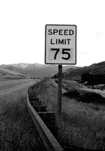
Data from the National Highway Traffic Safety Administration's (NHTSA) Fatal Analysis Reporting System show that States that increased their speed limits in 1996 experienced approximately 350 more Interstate fatalities than would have been expected based on historical trends. This is about 9 percent above expectations. Concurrently, the Interstate fatalities experienced in States that did not increase their speed limits in 1996 was consistent with pre-1996 trends. When compared to the estimated change in fatalities found in 1987 following the increase of speed limits on rural Interstates, the estimated increase in Interstate fatalities found in this study does follow the historical pattern of increases in fatalities being associated with increases in posted speed limits.
Many States are now reviewing their crash data to determine if the increased speed limits has a negative effect on safety, particularly on two-lane rural roads. Nearly all States have now raised their speed limits above the National Maximum Speed Limit (NMSL) levels. New Jersey is increasing its speed limits to 65 mi/h effective May 19. Connecticut, Puerto Rico, and the District of Columbia kept the 55 mi/h speed limit. Eleven States have differential speed limits for cars and trucks.
Details of the information was included in a Report to Congress on the Effects of Increased Speed Limits in the Post-65 Era. The report, which was sent to Congress on March 10, was required by Section 349 of the National Highway System Designation Act of 1995. A copy of the report in PDF format is available on the Office of Highway Safety's homepage at www.ohs.fhwa.dot.gov/speed/index.html.
- Janet A. Coleman, (202) 366-4668, janet.coleman@fhwa.dot.gov
Is the sky falling on traffic control systems at midnight December 31, 1999? The year 2000 (also known as "Y2K") may raise a problem for anyone who depends on a computer program in which the year is represented by a two-digit number, such as "98" for 1998. This may also include traffic control systems. Most newer traffic control systems will not have a problem. However, there is a potential problem for some of the older systems often referred to as the legacy systems.
Many traffic control system computer programs written 10 or 15 years ago when storage limitations encouraged such information economies are still running in some jurisdictions. The problem is that when the two-digit space allocated for "99" rolls over to 2000, the next number will be "00." Frequently, program logic assumes that the year number gets larger, not smaller, so "00" may wreak havoc in a program that hasn't been modified to account for the millennium. For example, some traffic signal controller computer programs are year sensitive because the day of the week is established by referencing the time of day and date. If the current software does not recognize a date with "00," it will skip ahead to the year 2001. This means that January 1 will be identified as Monday in lieu of Saturday. All rush hour timing patterns (and special functions like turn restriction operations controlled by electronic signs) will be in error. There may be some other date problems for traffic control systems. Many traffic control systems-centralized, closed loop, and distributed-either run on a time-of-day mode or use a time-of-day mode as a back up to a real-time or traffic responsive mode of operation.
In 1997, the Federal Government established formal policies and internal rules for addressing the Y2K problem. The Federal Government's strategy is based on five phases for addressing the problem: awareness, assessment, renovation, validation, and implementation. All traffic control system operators should be pro-active and establish a plan to address the year 2000 problem, now. The plan should include the following steps:
For more information concerning the Year 2000 information, check out our web site: https://www.fhwa.dot.gov/y2k
. - John McCracken, (202) 366-2219, john.mccracken@fhwa.dot.gov
A Microsoft Excel spreadsheet that automates the design and analysis procedures for the Long-Term Pavement Performance's (LTPP) improved guidelines for portland concrete cement pavements is now available. Simple to implement and easy to use, the new software features a "Sensitivity Analysis" capability that varies a user-selected parameter while leaving all other critical inputs constant. The design parameters that can be analyzed using the Sensitivity Analysis feature include modulus of rupture, elastic modulus of slab or base, base thickness, k-value, joint spacing, reliability, and standard deviation. Using this feature, a designer can, for example, determine the optimum elastic modulus of base material for a given pavement's thickness and joint spacing.
The new spreadsheet was developed to make it easier for highway managers and engineers to implement the improved design and analysis procedures, which were developed under NCHRP research and validated with LTPP data. These procedures were adopted by the American Association of State Highway and Transportation Officials (AASHTO) and published as a 1997 supplement to the 1993 AASHTO Guide for Design Pavement Structures. Improvements that are included in the '97 supplement include improved k-value selection criteria, consideration of curling and warping, joint spacing design, consideration of slab/base friction, and faulting and corner break prediction.
The new software is not intended to replace DARwin (the computerized version of AASHTO's '93 Guide), but rather to be used as an interim tool. It is anticipated that the improved guidelines will eventually be incorporated into DARwin or a new pavement design software that results from the AASHTO 2002 Guide. You may contact the Pavement Division for a copy of the new spreadsheet software.
- Mark Swanlund, (202) 366-1323, mark.swanlund@fhwa.dot.gov
The Garrett A. Morgan Technology and Transportation Futures Program is proud to be the U.S. sponsor of the World Road Association's International Essay Competition: Infrastructure and Transportation for the 21st Century. The essay competition will test the skills and imagination of today's upcoming transportation students and young professionals and place them among their peers from around the world.
Undergraduate and graduate university students and young transportation professionals (under age 35) are invited to submit essays in this international competition. The winner of the competition in the United States will be awarded a trip to attend the World Road Association Congress in Kuala, Lumpur, Malaysia, in October 1999.
Essays should present multimodal, multidisciplinary approaches to transportation and infrastructure challenges that can be applied around the world. The deadline for essay submission is September 30. For complete information about the competition, visit our Web site at www.international.fhwa.dot.gov or contact Sherif Gamal, (202) 366-2155, international@fwha.dot.gov

