
Also available as Adobe PDF (2 MB)
The New York State Department of Transportation (NYSDOT) identified that transportation improvements were needed to address concerns centered on the use of local streets by cross-border traffic as it enters and exits the existing U.S. Border Port of Entry/Peace Bridge Plaza (Plaza). The New York Gateway Connections Improvement Project was designed to help address the limited direct access between the Plaza and Interstate 190 (I-190). Existing direct access between those two roads was limited and required regional and international traffic to use the local street system. This limited direct access increased commercial traffic on the local streets, which were originally designed to meet only the needs of local traffic.
The Gateway Connections Project was proposed to reduce the use of local streets by international traffic, including both automobiles and trucks, passing through the Plaza. The project was located in the West Side neighborhood of the city of Buffalo in Erie County, New York. Major roadways in the study area included the Niagara Thruway (I-190), Porter Avenue, Baird Drive, Busti Avenue, and the I-190 ramp connections to and from the Plaza.
Figure 1 illustrates the project area. The Build Alternative of this project included construction of a new ramp to provide direct access from the Plaza to northbound I-190. It also included a new ramp from Porter Avenue to the existing I-190 northbound exit ramp to the Plaza. The combination of these new ramps allowed the removal of Baird Drive from Front Park and the conversion of the existing 1.8 acres of roadbed and sidewalk into additional green space. The removal of Baird Drive enabled 4.5 acres of green space located between Busti Avenue and Baird Drive to be reconnected to the greater park area. Construction of the new bridge also allowed for the construction of a new shared-use path along Porter Avenue connecting Front Park to LaSalle Park and the Niagara River waterfront. NYSDOT prepared a Draft Environmental Impact Statement (DEIS) for this project to fulfill requirements of the National Environmental Policy Act (NEPA) and the state review process in November 2013, followed by a Final EIS (FEIS) in April 2014. This project was approved by the Federal Highway Administration (FHWA) with a Record of Decision signed on June 3, 2014. (FHWA and NYSDOT 2014)
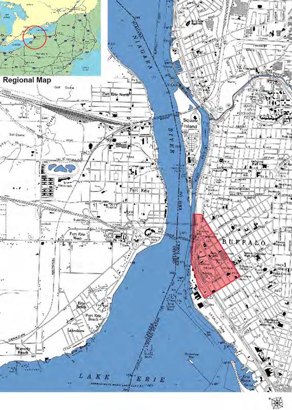
Figure 1. Gateway Connections Improvement Project area.
NYSDOT determined that a quantitative MSAT analysis was needed for this project. This determination was made in accordance with methodologies presented in NYSDOT’s The Environmental Manual (TEM) (NYSDOT 2012), which states that the FHWA “Interim Guidance Update on Mobile Source Air Toxic (MSAT) Analysis in NEPA Documents” (2012) should be followed for project-level MSAT analyses. The NYSDOT TEM guidance specifies use of the Motor Vehicle Emissions Simulator (MOVES) 2010b emission factor model. The FHWA Interim Guidance was used as a guidance document for this analysis. (FHWA 2012) The air quality analysis for this project also included the quantification of emissions from selected criteria pollutants, including a particulate matter (PM) hot-spot analysis.
This MSAT analysis was prepared in 2013. (FHWA 2014) The project was awarded on October 24, 2014, and project completion is expected in the summer of 2017. (NYSDOT 2016)
Three future analysis years—2015, 2025, and 2035—were modeled for all pollutants included in the air quality study for this project. The selection of these three years was made in accordance with the NYSDOT TEM, which recommends modeling years based on the build Estimated Time of Completion (ETC), ETC plus 10 years, and ETC plus 20 years (which is considered the full-build case). The ETC for this project was 2015. For all three projection years (2015, 2025, and 2035), emissions were calculated for a No Build Alternative and a Build Alternative to show trends in emissions over time as well as the emission impacts of the project in key years. Table 1 summarizes the MSAT emissions by pollutant in each modeled year and alternative.
Based on the analysis results shown in table 1, MSAT emissions in the area of the Gateway Connections Project are expected to decline by about 70 to 90 percent from 2015 to 2035, regardless of whether the project is built. The estimated difference in MSAT annual emissions between the No-Build and Build alternatives in each year shows no difference or only slight differences between the alternatives. Therefore, NYSDOT concluded that there is no appreciable difference in overall MSAT emissions when comparing the No-Build Alternative to the Build Alternative. (FHWA and NYSDOT 2014) In addition, emissions in both future years for both alternatives are predicted by MOVES to be lower than 2015 emissions as a result of Federal mobile source emission control programs and anticipated changes in vehicle technology. These changes result in an estimated decline of 38 percent for diesel PM up to a 95 percent decline of benzene between 2015 and 2035.
Diesel trucks are estimated to account for about 3 percent of the vehicle miles traveled (VMT) on the urban restricted roadways and about 9 percent on the urban unrestricted roadways, or about 4.6 percent of overall VMT. These diesel percentages were estimated for the 2015 a.m. peak period in the winter. The fraction of diesel VMT may differ slightly for other time periods.
Annual Emissions (tons/year) |
Percent Change |
||||||||
|---|---|---|---|---|---|---|---|---|---|
Pollutant |
2015 No Build |
2015 Build Alternative
|
2025 No Build |
2025 Build Alternative |
2035 No Build |
2035 Build Alternative | 2015 No Build to 2035 Build | 2035 No Build to 2035 Build | |
Acrolein |
0.26 |
0.24 |
0.12 |
0.12 |
0.06 |
0.06 |
-77% |
0.0% |
|
Benzene |
4.97 |
4.76 |
1.47 |
1.44 |
0.27 |
0.27 |
-95% |
0.0% |
|
1,3–Butadiene |
0.67 |
0.64 |
0.24 |
0.24 |
0.05 |
0.05 |
-93% |
0.0% |
|
Diesel PM |
24.9 |
23.3 |
17.9 |
17.8 |
15.7 |
15.5 |
-38% |
-1.3% |
|
Formaldehyde |
3.88 |
3.67 |
1.83 |
1.76 |
0.99 |
0.95 |
-76% |
-4.0% |
|
Polycyclic Organic Matter |
0.08 |
0.07 |
0.06 |
0.06 |
0.05 |
0.05 |
-38% |
0.0% |
|
Note: Emissions of naphthalene were reported as zero in all alternatives in the FEIS (FHWA 2014).
While emissions of naphthalene for this project were reported as 0, the POM emissions in table 1 may include naphthalene, as the air quality report for this study shows a screen shot of the MOVES2010b input screen of the modeled pollutants and processes selected and it includes naphthalene.
Figure 2 shows the road network included in the MSAT modeling of this project. To develop the affected network, NYSDOT attempted to identify the segments of the roadway network that would be affected by the proposed Gateway Connections Project in a meaningful way. To determine the boundary, they first analyzed the key intersections and then looked to establish which links affected those key intersections. Thus, the analysis went a couple of blocks beyond each of the key intersections to ensure that the entire affected area was included. This MSAT road network was defined by the network used in the PM hot-spot analysis, which was being done at the same time. This network was influenced by significant public involvement and concern regarding issues such as the location of schools and residences. A prior EIS established the road network for the Peace Bridge Project (the bridge between the United States and Canada) and this analysis used the same study area.
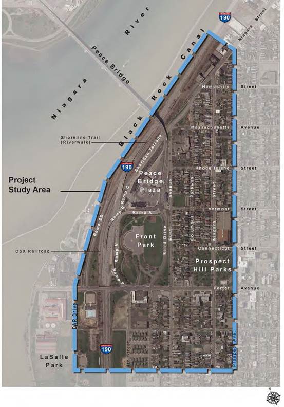
Figure 2. Gateway Connections Project affected transportation network.
The U.S. Environmental Protection Agency’s (EPA) MOVES2010b model was used to calculate onroad emissions (EPA 2012). MOVES was run in inventory mode at the project scale using four daily one-hour time periods—6 a.m. to 7 a.m., 11 a.m. to noon, 6 p.m. to 7 p.m., and 11 p.m. to midnight—to represent four daily time periods: morning (6 a.m. to 9 a.m.), midday (9 a.m. to 4 p.m.), afternoon (4 p.m. to 7 p.m.) and overnight (7 p.m. to 6 a.m.). For each daily time period, MOVES was run for four months (January, April, July, and October) to represent the four seasons. These time period combinations were used for the No-Build and Build alternatives for each analysis year (2015, 2025, and 2035), resulting in a total of 96 MOVES runs. Emissions of MSAT pollutants were calculated in the same MOVES runs that were developed for the PM and criteria pollutant analyses. The traffic pattern on the bridge is atypical of most roads, in terms of both traffic timing and fleet makeup. For example, there are more trucks at night and more night traffic, generally, than a typical traffic pattern. Thus, modeling multiple time periods in MOVES was important to capture these variations in the fleet mix and travel volumes.
Table 3 summarizes the selections that were made for each of the MOVES parameters in the MOVES Graphical User Interface. The analysis is located entirely within Erie County, and is run at the project level for each analysis year, time period, and alternative.
Local data from NYSDOT was used wherever it was possible and available, such as fuel mix and meteorology. Hourly link-level travel volumes were modeled for the affected network. The selected speeds modeled were the posted speed limits—55 mph for urban restricted access roads and 30 mph for urban unrestricted access roads, as well 0 mph to represent idling in queues.
Table 3. Selection of motor vehicle emissions simulator parameters.
| Inputs | Selections |
|---|---|
Scale |
Domain/scale: Project Calculation type: Inventory |
Time Spans |
Time aggregation level: Hour Years: 2015, 2025, 2035 Months: January, April, July, October Hours: 6 a.m. to 7 a.m., 11 a.m. to noon, 6 p.m. to 7 p.m., and 11 p.m. to midnight Days: Weekdays |
Geographic Bounds |
Erie County |
Vehicles/Equipment |
Diesel fuel combination long haul truck Gasoline passenger car |
Road Type |
Urban restricted access Urban unrestricted access |
| Inputs | Selections |
|---|---|
Pollutantsa |
Total Gaseous Hydrocarbons Non-Methane Hydrocarbons Non-Methane Organic Gases Volatile Organic Compounds Carbon Monoxide Oxides of Nitrogen Sulfur Dioxide Primary Exhaust PM10-Total Primary PM10-Organic Carbon Primary PM10-Elemental Carbon Primary PM10-Sulfate Particulate Primary PM10-Brakewear Particulate Primary PM10-Tirewear Particulate Primary Exhaust PM2. 5-Total Primary PM2. 5-Organic Carbon Primary PM2. 5-Elemental Carbon Primary PM2. 5-Sulfate Particulate Primary PM2. 5-Brakewear Particulate Primary PM2. 5-Tirewear Particulate Total Energy Consumption Methane Nitrous Oxide Atmospheric CO2 CO2 Equivalent Benzene 1,3-Butadiene Formaldehyde Acrolein Polycyclic Aromatic Hydrocarbons |
Processes |
Running Exhaust Crankcase Running Exhaust Brakewear Tirewear |
a Since the same MOVES runs were used for all of the pollutants included in the air quality analyses for this project, the list here includes more pollutants that just those that are needed for the MSAT analysis. This is also the reason for including PM brakewear and tirewear, which are not included in the diesel PM for an MSAT analysis.
| Inputs | Selections |
|---|---|
General Output |
Mass units: grams Energy units: million Btu Distance units: mi Activity: distance traveled, source hours, source hours idling, source hours operating, population |
Output Emissions Detail |
Hour Link Model year Fuel type Emission process Road type Source use type |
| Input | Data Source |
Notes |
|---|---|---|
Age Distribution |
NYSDOT and New York State Department of Environmental Conservation (NYSDEC) |
Erie County data for 2011 |
Fuel Type and Technologies |
NYSDOT and NYSDEC |
Erie County data for 2011 |
Fuel Supply |
NYSDOT and NYSDEC |
Erie County data for 2011 |
Fuel Formulation |
NYSDOT and NYSDEC |
Erie County data for 2011 |
Meteorology Data |
NYSDOT and NYSDEC |
Erie County data for 2011 |
I/M Programs |
NYSDOT and NYSDEC |
Erie County data for 2011 |
Links |
Traffic analysis |
— |
Link Source Types |
Traffic analysis |
Assumed to be the same for each alternative |
The detailed output from the MOVES2010b model runs was used to calculate annual MSAT emissions in the study area for the No-Build and Build alternatives. The hourly emissions output from MOVES2010b was post-processed to estimate total annual emissions for the MSAT pollutants. For example, the emissions from the MOVES run representing the winter 2015 No-Build morning peak period were summed over all links, vehicle types, and road types and then these totals were multiplied by the number of hours in the morning peak period (6 a.m. to 9 a.m., or 3 hours), and then by the number of days in the winter period (December through February). This procedure was repeated for each time period and season for each analysis year and for each alternative.
This analysis shows a general emissions reduction for all MSAT compounds from 2015 to 2035 in the study area, which is consistent with the national trend. These reductions are primarily due to Federal motor vehicle and fuel control programs, even as vehicle activity increases during this time period. The FEIS states “there is no appreciable difference in overall MSAT emissions when comparing the Build Alternative to the No-Build Alternative. In addition, emissions in future years for both alternatives (i.e., in 2025 and 2035) are predicted by MOVES2010b to be lower than 2015 emissions as a result of the EPA’s national mobile source control programs and anticipated changes in vehicle technology.” (FHWA 2014)
The NYSDOT contractor performing this project-level air-quality analysis did not encounter any particular difficulty in obtaining the MOVES data needed for the MSAT analysis as NYSDOT already had most of the needed data, since they were building on previous work done for this project. (Wattle 2015)
One suggestion from the project analysts was that future MSAT guidance documents should provide clarification on what pollutants must be covered by the MSAT analysis, and under what circumstances. For example, should polycyclic organic matter (POM) include both gas and particle forms? This need for clarification sometimes slowed down the MSAT modeling process. (Jin 2015) Note that FHWA’s current guidance specifies the pollutants that should be included to model POM. (FHWA 2015) Additionally, NYSDOT provided guidance to the MSAT consultant indicating that POM is essentially polycyclic aromatic hydrocarbons (PAH) without the naphthalene.
This project probably could have been streamlined somewhat by doing fewer MOVES runs, for example having only three daily time periods instead of four, or combining the fall/spring runs. It is likely that some of the runs could have been determined in advance to be of minimal interest for an MSAT analysis. Thus, combining some of these runs would have been possible and saved time. (Wattle 2015) However, these additional MOVES runs would still have been needed for the PM analysis, so in this instance, streamlining the MOVES runs for the MSAT analysis might not have had much of an impact in reducing the time needed for the analysis.
Due to the nature of this project, capturing the idling emissions was an important component of the MSAT and PM analyses. Using the project scale of MOVES made it possible to explicitly model idling emissions.
For this project, the consultant team wrote a modeling protocol prior to performing the MOVES analysis, which outlined how they were planning to use MOVES. This plan was then distributed to NYSDOT for review and comment. This allowed for more input from NYSDOT early in the process and helped things go more smoothly. (Wattle 2015)
EPA 2012: “Motor Vehicle Emission Simulator (MOVES)—User Guide for MOVES2010b,” EPA-420-B-12-001b, U.S. Environmental Protection Agency Office of Transportation and Air Quality, June 2012.
FHWA 2012: “Interim Guidance Update on Mobile Source Air Toxic Analysis in NEPA,” Federal Highway Administration, December 6, 2012.
FHWA 2014: “Gateway Connections Improvement Project to the US Peace Bridge Plaza—Final Environmental Impact Statement“, FHWA-NY-EIS-13-02-F, April 4, 2014, available at https://www.dot.ny.gov/portal/page/portal/content/delivery/Main-Projects/576080-Home/576080-Repository/NY%20Gateway_FEIS_Main%20Document_April2014.pdf.
FHWA 2015: “Frequently Asked Questions (FAQ): Conducting Quantitative MSAT Analysis for FHWA NEPA Documents,” Federal Highway Administration, September 2, 2015, available at http://www.fhwa.dot.gov/environment/air_quality/air_toxics/policy_and_guidance/moves_msat_faq.cfm.
FHWA and NYSDOT 2014: “Joint Record of Decision/Findings Statement, New York Gateway Connections Improvement Projects to Peace Bridge Plaza,” Signed June 3, 2014. https://www. dot. ny. gov/nygateway.
Jin 2015: Shengxin Jin, New York State Department of Transportation, The Office of Environment / Environmental Science Bureau, personal communication with Jackson Schreiber, SC&A, Inc. , October 20, 2015.
NYSDOT 2012: The Environmental Manual (TEM) (formerly known as Environmental Procedures Manual (EPM)), Chapter 1. 1 - Air Quality, January 2001, Updated December 2012. https://www.dot.ny.gov/divisions/engineering/environmental-analysis/manuals-and-guidance/epm.
NYSDOT 2016: “New York Gateway Connections Improvement Project” (website). www.dot.ny.gov/nygateway, accessed April 2016.
Wattle 2015: Bruce Wattle, Air Quality Specialist, Ecology and the Environment, Inc., personal communication with Jackson Schreiber, SC&A, Inc., December 7, 2015.

