
CMAQ Cost: $54 million
Total Project Cost: $140 million
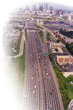
The Atlanta region is known for its traffic congestion; it is one of the fastest growing metropolitan areas in the country. Atlanta's population nearly doubled from 1.6 million to 3.0 million between 1982 and 2000, and system-wide daily vehicle miles traveled tripled over this period.26 As host to the 1996 Olympic Summer Games, Atlanta was expected to draw some two million visitors plus thousands of athletes, coaches, and officials from around the world. Given the region's reputation for traffic congestion, regional leaders were concerned about accommodating the influx of people and traffic for the Olympics. Few things could destroy the excitement of the Olympics-not to mention the reputation of the region and economic opportunities stemming from the event-faster than transportation gridlock. Solutions were needed to improve mobility for the games, as well as to promote the continued economic well-being of the region.
The Advanced Transportation Management System, or NAVIGATOR, was developed to help better manage traffic flow and provide real-time traffic information to improve transportation decisions and public information. NAVIGATOR is a computerized transportation communication system that employs fiber optic technology to gather traffic information. It uses video detection, radar detectors, and more than 450 closed-circuit television cameras to monitor traffic flow. The system enables control center managers to detect traffic incidents and congestion rapidly, and subsequently dispatch Highway Emergency Response Operators (HEROs). Five ramp meters are used to control highway traffic flow, and information technologies (such as 67 changeable message signs, the Internet, and 140 information kiosks) help provide motorists with real-time traffic information. In developing the system, more than 400 traffic intersections were upgraded to improve signal coordination throughout Atlanta and the metropolitan region.
In addition to elements that improve highway traffic flow, the system includes transit management, electronic fare payment, and multimodal traveler information. The Metropolitan Atlanta Rapid Transit Authority (MARTA) has access to information generated by the ATMS and shares information on road conditions. For example, information on an accident that is radioed into MARTA by bus drivers is available to ATMS to help manage traffic patterns and incident response.
The system is housed in a $14 million transportation management center (TMC). Operated by the Georgia Department of Transportation (and centrally located in Atlanta on the same compound as the Georgia State Patrol and the Georgia Emergency Management Agency), the TMC serves as the control center for transportation emergencies. Having all surveillance and control functions under one roof facilitates decision-making and helps Atlanta's transportation officials more effectively manage the day-to-day demands of the transportation system. The TMC is linked to seven regional Transportation Control Centers in Clayton, Cobb, Dekalb, Fulton, and Gwinnett counties, the City of Atlanta, and MARTA. These satellite facilities and the TMC monitor 90 miles of interstate highway in the Atlanta region and represent the forefront of ITS traffic data gathering, communications, analysis, and incident-response activities.

The incident management components of the system resulted in substantial savings in traveler delay. Using conservative estimates, Georgia DOT estimates that the incident management components of NAVIGATOR have reduced the average incident duration by 23 minutes, from an average of 64 minutes to 41 minutes. All elements of incident management are faster: incident detection and verification are faster due to traffic camera coverage; response identification and dispatch are speeded up by the computer system; and response time and clearance are also faster due to the HEROs (previously, local police and fire agencies responded to freeway incidents). It is estimated that, in total, the incident management components of NAVIGATOR have resulted in nearly 3.2 million hours in reduced delay time per year for travelers on Atlanta's highways. The delay savings accrued mostly during the peak hours of traffic, with 6:00 a.m. to 10:00 a.m. delay reductions of 1.3 million hours and 3:00 p.m. to 7:00 p.m. reductions of 1.9 million hours. These savings have resulted in a cost savings of $45 million per year for travelers.27
Beyond the incident management components, NAVIGATOR also provided motorists with information to make informed decisions regarding their traveling options, including ways to avoid spending time stuck in traffic delays. The system also improved the reliability of transit schedule information and decreased traveler waiting time. The Georgia DOT suggests that other benefits of the system include improved roadway safety, reduced air pollution, and more efficient use of emergency services.
Estimated Emissions Benefits614 kg/day VOC, 578 kg/day NOx ContactMark Demidovich |
|

