One of the objectives of this project was to develop a set of VSP profiles that simulate specific types of congestion conditions that can be input to the MOVES model and that are developed by transportation analysis techniques in order to improve MOVES inputs beyond average speed. The analytical methods used for planning applications are much simpler than microsimulation and as a result their outputs are of far lower resolution. In this study, microsimulation models were used to develop VSP profile inputs for MOVES under a variety of congestion levels and traffic conditions. This approach offers a level of refinement beyond using average speeds, which do not capture the details of how congestion forms and dissipates in practice. For example, vehicle activity is radically different under the different "regimes" of congestion, such as:
In theory, using the analytical relationships derived from microsimulation allow more representative emissions estimates for project level analysis, because the driving cycles more closely match actual on-road conditions than simply using the MOVES default values. (However, the project did not test for any differences, but the data that was developed can be used for such a purpose.) Two sets of VSP profiles were developed under this project one set of profiles simulates typical congested conditions (e.g., freeway ramps and interchange areas, freeway incidents, and signalized arterials) and the other set of VSP profiles simulates typical conditions at container ports and intermodal facilities. The development of each of these sets of profiles is discussed below followed by a discussion of the post-processing of the microsimulation outputs.
For the development of the VSP profiles modeling congested roadway conditions, the Interstate 805 (I-805) corridor in San Diego, California was used to provide sample data for the simulations. The size of the test network used was determined through previous analysis conducted for FHWA as part of the Integrated Corridor Management (ICM) initiative. Cambridge Systematics, Inc. (CS) extracted this test network directly from the calibrated I-805 Transmodeler network being used for FHWA's ICM modeling studies. CS has developed and calibrated this microsimulation model network using TransModeler Version 2.5 Build 980 with a base calibrated year of 2006. The I-805 corridor consists of the area between post mile 0 at the U.S./Mexican Border and mile 28.8 at the junction of I-5 and I-805. The Corridor includes 33 southbound and northbound interchanges. The Corridor also includes additional arterials, Tier 1 (major) and Tier 2 (minor) arterials. This application was used because the model has already been calibrated to field conditions.
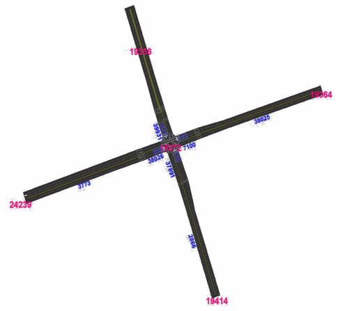
Four different types of congestion scenarios were modeled using this test network: 1) freeway on-ramps, 2) freeway-to-freeway interchanges, 3) freeway incidents with lane blockages, and 4) signalized arterials. Figure II-1 shows the test network used for the simple on-ramp condition with and without ramp metering as well as for the freeway incident scenarios. The "incident blockage locations" shows where incidents of different lane blockages and durations were coded in the incident scenarios. The ramp extracted was the on-ramp to I-805 southbound from Telegraph Canyon Road. At this location, I-805 southbound has four lanes and a speed limit of 65 miles per hour (mph), and the on-ramp is a single lane on-ramp. All roadways are modeled as level grades. Potential bottlenecks both upstream and downstream of the on-ramp were removed to ensure that the on-ramp functioned isolated from other system bottlenecks. Figure II-2 shows the network used for the freeway-to-freeway interchange scenarios. Figures II-3 and II-4 show the network used for the signalized arterial scenarios. This was extracted from the ICM network as the intersection of National City Boulevard (almost vertical links) and 8th Street (almost horizontal links). The location of this intersection is between I-5 and I-805 in Chula Vista.
Figure II-1. Sub-Network Configuration for On-Ramp, Ramp Metering, and Incident Scenarios
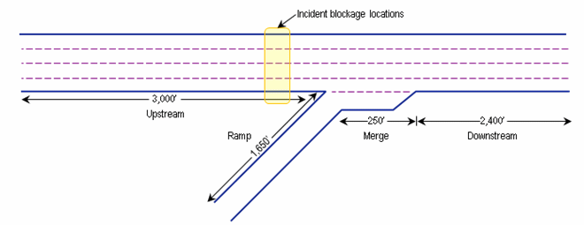
Figure II-2. Sub-Network Configuration for Freeway to Freeway Interchange
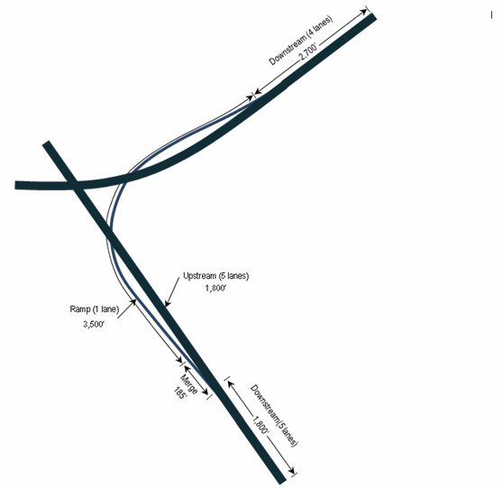
Note: This subnetwork is the interchange of I-805 and I-8. Vehicles are merging from I-8 westbound onto I-805 southbound.
Figure II-3. Sub-Network Configuration for Signalized Arterial
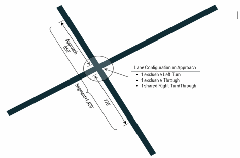
Figure II-4. Lane Detail for Signalized Arterial Sub-network
As roadway capacity is not an input to the microsimulation software, several tests were conducted to estimate the capacity or maximum throughput of the simulated roadways. While keeping ramp volumes near zero, the mainline approach volumes were increased and the maximum throughput of the mainline roadway measured. Similarly, while keeping mainline ramp volumes low, ramp volumes were increased and the maximum ramp throughput measured.
During these tests, all parameters established during the calibration and validation of the larger simulation corridor model were kept constant, and only volumes were varied. A vehicle fleet mix of 100 percent passenger cars was used during the throughput tests, because the purpose was to estimate capacities which are expressed in passenger car-equivalents. Table II-1 shows the travel volume capacities for the mainline roadways and ramps that resulted from the simulation model compared with the capacities of the Highway Capacity Manual (HCM).
| Approach | Number of Passenger Cars per Hour per Lane | |
|---|---|---|
|
Mainline |
Ramp |
HCM Capacity |
2,400 |
2,000 |
Maximum Throughput in Simulation Model |
2,225 |
2,100 |
In order to test the operating conditions of the different congestion scenarios under specific volume-to-capacity (V/C) procedures, the maximum throughput observed in the simulation model, as shown in Table II-1, was used as the definition of capacity in place of the HCM procedures. The simulation procedures are based on a model calibrated to the conditions specific to San Diego, so we felt it was more appropriate to use values based on them.
For freeways, demand volumes were varied independently on the mainline and the ramp approaches into the merge area to meet the target V/C ratios during the peak hour of the simulation. The observed volume profile of demands across the peak period was kept constant and adjusted so that the peak hour volume (in passenger car equivalents) divided by capacity was equal to the V/C ratio being tested. A four-hour peak period was simulated, with the peak occurring in the second hour. This allows for the simulation to "warm-up." The demand volumes for hours outside of the peak period were developed by applying factors from San Diego field data. Results are reported for the peak and the hour after the peak to capture the effect of queuing. Trucks are assumed to be a constant 8 percent of total volume. This truck percentage is believed to be a representative value for an urban freeway. (At the planning level, detailed future forecasts of truck types are almost never available, so using a representative value is reasonable. However, we expect that the emissions characteristics will change under assumptions of different truck distributions.) For comparison purposes (which indicate that the selected value of 8 percent is reasonable), the default VMT percentage in MOVES, which is based on 1999 Highway Performance Monitoring System reporting, is 7.5 percent for trucks and 7.8 percent if trucks and buses are combined.
As discussed above, microsimulation runs were performed for four different categories of scenarios: freeway on-ramps, freeway-to-freeway interchanges, freeway incidents, and signalized arterials. Each scenario was modeled under a range of V/C ratios. The specific V/C ratios and other scenario conditions run in the microsimulation model are as follows:
Freeway On-Ramp
Freeway-to-Freeway Interchange
Freeway Incident
Signalized Arterial
The application of these profiles is provided in Chapter III.
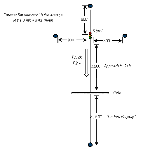
The second set of VSP profiles developed under this project to simulate travel at ports or intermodal facilities were developed using microsimulation models for a simple network to get an idea of the emission-producing activity of trucks operating on port grounds. The goal of these simulation tests was to capture the movement of trucks under three conditions: (1) on the local street network near the port, where they mix with autos, (2) approaching and stopping at the port gate, and (3) inside the port gate. Each of these conditions was modeled as a separate network link, as shown in Figure II-5.
For this simulation, the signalized arterial network, developed as described above for the congested condition simulations, was extended and adapted to model the intersection approach portion of this port simulation network. The V/C ratio of the signalized intersection was set at 0.80, based on the signalized arterial runs from the congested condition modeling. The trucks were evenly distributed on the approaches to the signalized intersection and only trucks (i.e., no cars) turned onto the approach to the gate. It was assumed that the entrance was solely for trucks and that employees would access the port via a different gate.
For the link simulating the approach to the gate, the only parameter that was varied was truck demand at the gate: 10, 20, 30, 40, 50, and 60 trucks per hour. The processing time at the gate was a constant four minutes per truckconsistent across the hours of simulation, for both entering and exiting vehicles. The value of four minutes per truck was based on observations by CS staff that had done previous work at port facilities.
Inside the gate, a simple, hypothetical configuration was developed. This was done because port property road networks are site-specific and it was felt that a simple network would be adequate to capture the low speed driving with frequent stop truck activity on port property. On this link inside the gate, trucks were restricted to a maximum speed of 20 mph. Trucks were also forced to idle for two 15-minute periods once on the port property. Total access and on-site times for trucks were not calculated, but in addition to the wait and idle times used, trucks are delayed by queues throughout the subnetwork.
Figure II-5. Simulation Network for Port Gate Simulation
The output of each simulation run is a vehicle trajectory file that, for every second of the simulation, indicates the speed and acceleration of every vehicle in the network, i.e., provides the instantaneous speed and acceleration. Such data is too finely grained for input to MOVES and required summarizing to the required MOVES input structure. Initially, the individual trajectories were summarized to develop second-by-second MOVES driving cycles by taking the average speed for all vehicles on each link for every second and assuming that this represented a realistic driving cycle. However, vehicle speeds will vary substantially over a link for a one-second snapshot, and the use of these driving cycles could lead to erroneous results when input to MOVES.
Instead, since both speed and acceleration are available in the microsimulation output for every vehicle for every second of simulation, MOVES operating mode distributions based on VSP were computed instead. According to EPA's recent draft particulate matter (PM) hot spot guidance (EPA, 2010), this is thought to be a much more accurate way of capturing driving cycle patterns when literally thousands of vehicles have their trajectories traced, as in simulation. The equation used to compute VSP, based on the most recently available information, was:2
VSP = (Av + Bv2 + Cv3 + mav) / mfixed
where:
m = sourceMass (metric tons)
A = rolling Term A
B = rotating Term B
C = drag Term C
v = average vehicle velocity (m/s)
a = vehicle acceleration (m/s2)
mfixed = fixedMassFactor (metric tons)
Since grade was set at 0 percent in the simulation, the term for it falls out of the equation and is not used.
Two vehicle types were present in the simulations passenger cars and combination trucks so they were treated separately. The reason for using only two vehicle types is that for planning applications, detailed truck distributions are not available, and we tried to match the simulations to data that planners have on hand. Velocity and acceleration values are as estimated by the microsimulation model. The following constant terms for the above equations were used. These values are the default data for these vehicle types contained in the SourceUseType table of the MOVES2010 default database.
Passenger Cars
A = 0.156461
B = 0.00200193
C = 0.000492646
m = 1.4788
mfixed = 1.4788
Combination Trucks
A = 2.08126
B = 0
C = 0.00418844
m = 31.4038
mfixed = 17.1
Based on the vehicle speed and the calculated VSP, a MOVES operating mode ID was then assigned to each second. Then, the amount of time the vehicle was operating in each operating mode was calculated so that the final operating mode distributions could be prepared. Table II-2 shows the MOVES operating modes that were used in this project3. These are only some of the standard MOVES operating modes. A list of all the operating modes present in the MOVES default database4 is provided in Appendix A. Operating mode distributions were then assigned for each applicable unique combination of pollutant and process ID. The operating mode distribution files were constructed for both the peak hour and the hour immediately following the peak.
MOVES Operating Mode ID |
Operating Mode |
|---|---|
0 |
Braking |
1 |
Idling |
11 |
Low Speed Coasting; VSP< 0; 1<=Speed<25 |
12 |
Cruise/Acceleration; 0<=VSP< 3; 1<= Speed<25 |
13 |
Cruise/Acceleration; 3<=VSP< 6; 1<=Speed<25 |
14 |
Cruise/Acceleration; 6<=VSP< 9; 1<=Speed<25 |
15 |
Cruise/Acceleration; 9<=VSP<12; 1<=Speed<25 |
16 |
Cruise/Acceleration; 12<=VSP; 1<=Speed<25 |
21 |
Moderate Speed Coasting; VSP< 0; 25<=Speed<50 |
22 |
Cruise/Acceleration; 0<=VSP< 3; 25<=Speed<50 |
23 |
Cruise/Acceleration; 3<=VSP< 6; 25<=Speed<50 |
24 |
Cruise/Acceleration; 6<=VSP< 9; 25<=Speed<50 |
25 |
Cruise/Acceleration; 9<=VSP<12; 25<=Speed<50 |
26 |
Cruise/Acceleration; 12<=VSP; 25<=Speed<50 |
27 |
Cruise/Acceleration; 12<=VSP<18; 25<=Speed<50 |
28 |
Cruise/Acceleration; 18<=VSP<24; 25<=Speed<50 |
29 |
Cruise/Acceleration; 24<=VSP<30; 25<=Speed<50 |
30 |
Cruise/Acceleration; 30<=VSP; 25<=Speed<50 |
33 |
Cruise/Acceleration; VSP< 6; 50<=Speed |
35 |
Cruise/Acceleration; 6<=VSP<12; 50<=Speed |
36 |
Cruise/Acceleration; 12 <= VSP; 50<=Speed |
37 |
Cruise/Acceleration; 12<=VSP<18; 50<=Speed |
38 |
Cruise/Acceleration; 18<=VSP<24; 50<=Speed |
39 |
Cruise/Acceleration; 24<=VSP<30; 50<=Speed |
40 |
Cruise/Acceleration; 30<=VSP; 50<=Speed |
400 |
Tire wear; idling |
501 |
Brake wear; stopped |
The links for which the data are presented depend on the test network, as indicated in Figures II-1 through II-5. For example, for the on-ramp scenarios, there are four links for which the traffic data are aggregated. These were all constructed from smaller segments in the microsimulation:
DOWNSTREAM: link downstream of the merge area (3,000 feet [ft.]).
UPSTREAM: link immediately upstream of the merge area (3,000 ft.).
MERGE AREA: link defined by the acceleration/merge lane from the on-ramp (275 ft.).
RAMP: the actual on-ramp, exclusive of the acceleration/merge lane (1,650 ft.).
The three links for which the operating mode distributions were developed for the port simulations are shown in Figure II-5 and described below:
INTERSECTION APPROACH: the average of the three 800-foot approach links at the signalized intersections; these are the source links for the trucks that will access the port.
APPROACH TO GATE: link immediately upstream the gate (2,500 ft.).
ON PORT PROPERTY: an aggregation of three links inside the gate (total: 8,940 ft.).
The MOVES operating mode profile files only contain a link identifier. Table II-3 provides a mapping of the link identifier included in the MOVES files for each scenario with a description of the link modeled.
Scenarios |
Link Description |
Link ID |
|---|---|---|
On-ramp with/without metering; incidents |
Merge area |
1 |
On-Ramp |
2 |
|
Downstream from merge area |
3 |
|
Upstream from merge area |
4 |
|
Freeway-to-freeway |
Merge area |
1 |
On-Ramp |
2 |
|
Downstream from merge area |
3 |
|
Upstream from merge area |
4 |
|
Downstream from merge area #2 |
5 |
|
Signalized arterial (pre-timed/actuated) |
Entire segment |
8 |
Intersection approach only |
9 |
|
Port gate |
Gate approach |
21 |
Intersection approach |
23 |
|
Inside gate |
30 |
Tables II-4, II-5, and II-6 list the names of the resulting MOVES operating mode distribution files that correspond to each scenario.
Scenario |
Condition |
V/C Ratio |
File Name |
|---|---|---|---|
Signalized Arterial |
Actuated |
0.70 |
Arterial_Actuated_0.70_OP_MODE |
0.80 |
Arterial_Actuated_0.80_OP_MODE |
||
0.90 |
Arterial_Actuated_0.90_OP_MODE |
||
0.95 |
Arterial_Actuated_0.95_OP_MODE |
||
1.00 |
Arterial_Actuated_1.00_OP_MODE |
||
1.10 |
Arterial_Actuated_1.10_OP_MODE |
||
1.20 |
Arterial_Actuated_1.20_OP_MODE |
||
Pretimed |
0.70 |
Arterial_Pretimed_0.70_OP_MODE |
|
0.80 |
Arterial_Pretimed_0.80_OP_MODE |
||
0.90 |
Arterial_Pretimed_0.90_OP_MODE |
||
0.95 |
Arterial_Pretimed_0.95_OP_MODE |
||
1.00 |
Arterial_Pretimed_1.00_OP_MODE |
||
1.10 |
Arterial_Pretimed_1.10_OP_MODE |
||
1.20 |
Arterial_Pretimed_1.20_OP_MODE |
||
Freeway On-Ramp |
Without ramp metering |
0.90 |
VC_0.90_On_Ramp_OP_MODE |
1.00 |
VC_1.00_On_Ramp_OP_MODE |
||
1.10 |
VC_1.10_On_Ramp_OP_MODE |
||
1.15 |
VC_1.15_On_Ramp_OP_MODE |
||
1.20 |
VC_1.20_On_Ramp_OP_MODE |
||
1.25 |
VC_1.25_On_Ramp_OP_MODE |
||
1.40 |
VC_1.40_On_Ramp_OP_MODE |
||
1.50 |
VC_1.50_On_Ramp_OP_MODE |
||
With ramp metering |
0.90 |
VC_0.90_On_Ramp_with_Metering_OP_MODE |
|
1.00 |
VC_1.00_On_Ramp_with_Metering_OP_MODE |
||
1.15 |
VC_1.15_On_Ramp_with_Metering_OP_MODE |
||
1.20 |
VC_1.20_On_Ramp_with_Metering_OP_MODE |
||
1.25 |
VC_1.25_On_Ramp_with_Metering_OP_MODE |
||
1.40 |
VC_1.40_On_Ramp_with_Metering_OP_MODE |
||
1.50 |
VC_1.50_On_Ramp_with_Metering_OP_MODE |
||
Freeway to Freeway Interchange |
0.90 |
VC_0.90_Fwy2Fwy_OP_MODE |
|
1.00 |
VC_1.00_Fwy2Fwy_OP_MODE |
||
1.10 |
VC_1.10_Fwy2Fwy_OP_MODE |
||
1.15 |
VC_1.15_Fwy2Fwy_OP_MODE |
||
1.20 |
VC_1.20_Fwy2Fwy_OP_MODE |
||
1.25 |
VC_1.25_Fwy2Fwy_OP_MODE |
||
1.40 |
VC_1.40_Fwy2Fwy_OP_MODE |
||
1.50 |
VC_1.50_Fwy2Fwy_OP_MODE |
||
Scenario |
Condition |
V/C Ratio |
Duration (minutes) |
File Name |
|---|---|---|---|---|
Freeway Incident |
Blockage |
0.90 |
30 |
Inc_1Lane_30mins_0.90_OP_MODE |
45 |
Inc_1Lane_45mins_0.90_OP_MODE |
|||
60 |
Inc_1Lane_60mins_0.90_OP_MODE |
|||
90 |
Inc_1Lane_90mins_0.90_OP_MODE |
|||
1.00 |
30 |
Inc_1Lane_30mins_1.00_OP_MODE |
||
45 |
Inc_1Lane_45mins_1.00_OP_MODE |
|||
60 |
Inc_1Lane_60mins_1.00_OP_MODE |
|||
90 |
Inc_1Lane_90mins_1.00_OP_MODE |
|||
1.15 |
30 |
Inc_1Lane_30mins_1.15_OP_MODE |
||
45 |
Inc_1Lane_45mins_1.15_OP_MODE |
|||
60 |
Inc_1Lane_60mins_1.15_OP_MODE |
|||
90 |
Inc_1Lane_90mins_1.15_OP_MODE |
|||
1.25 |
30 |
Inc_1Lane_30mins_1.25_OP_MODE |
||
45 |
Inc_1Lane_45mins_1.25_OP_MODE |
|||
60 |
Inc_1Lane_60mins_1.25_OP_MODE |
|||
90 |
Inc_1Lane_90mins_1.25_OP_MODE |
|||
1.40 |
30 |
Inc_1Lane_30mins_1.40_OP_MODE |
||
45 |
Inc_1Lane_45mins_1.40_OP_MODE |
|||
60 |
Inc_1Lane_60mins_1.40_OP_MODE |
|||
90 |
Inc_1Lane_90mins_1.40_OP_MODE |
|||
Blockage |
0.90 |
30 |
Inc_2LANES_30MINs_0.90_OP_MODE |
|
45 |
Inc_2LANES_45MINs_0.90_OP_MODE |
|||
60 |
Inc_2LANES_60MINs_0.90_OP_MODE |
|||
90 |
Inc_2LANES_90MINs_0.90_OP_MODE |
|||
1.00 |
30 |
Inc_2LANES_30MINs_1.00_OP_MODE |
||
45 |
Inc_2LANES_45MINs_1.00_OP_MODE |
|||
60 |
Inc_2LANES_60MINs_1.00_OP_MODE |
|||
90 |
Inc_2LANES_90MINs_1.00_OP_MODE |
|||
1.15 |
30 |
Inc_2LANES_30MINs_1.15_OP_MODE |
||
45 |
Inc_2LANES_45MINs_1.15_OP_MODE |
|||
60 |
Inc_2LANES_60MINs_1.15_OP_MODE |
|||
90 |
Inc_2LANES_90MINs_1.15_OP_MODE |
|||
1.25 |
30 |
Inc_2LANES_30MINs_1.25_OP_MODE |
||
45 |
Inc_2LANES_45MINs_1.25_OP_MODE |
|||
60 |
Inc_2LANES_60MINs_1.25_OP_MODE |
|||
90 |
Inc_2LANES_90MINs_1.25_OP_MODE |
|||
1.40 |
30 |
Inc_2LANES_30MINs_1.40_OP_MODE |
||
45 |
Inc_2LANES_45MINs_1.40_OP_MODE |
|||
60 |
Inc_2LANES_60MINs_1.40_OP_MODE |
|||
90 |
Inc_2LANES_90MINs_1.40_OP_MODE |
|||
Blockage |
0.90 |
30 |
Inc_3LANES_30MINs_0.90_OP_MODE |
|
45 |
Inc_3LANES_45MINs_0.90_OP_MODE |
|||
60 |
Inc_3LANES_60MINs_0.90_OP_MODE |
|||
90 |
Inc_3LANES_90MINs_0.90_OP_MODE |
|||
1.00 |
30 |
Inc_3LANES_30MINs_1.00_OP_MODE |
||
45 |
Inc_3LANES_45MINs_1.00_OP_MODE |
|||
60 |
Inc_3LANES_60MINs_1.00_OP_MODE |
|||
90 |
Inc_3LANES_90MINs_1.00_OP_MODE |
|||
1.15 |
30 |
Inc_3LANES_30MINs_1.15_OP_MODE |
||
45 |
Inc_3LANES_45MINs_1.15_OP_MODE |
|||
60 |
Inc_3LANES_60MINs_1.15_OP_MODE |
|||
90 |
Inc_3LANES_90MINs_1.15_OP_MODE |
|||
1.25 |
30 |
Inc_3LANES_30MINs_1.25_OP_MODE |
||
45 |
Inc_3LANES_45MINs_1.25_OP_MODE |
|||
60 |
Inc_3LANES_60MINs_1.25_OP_MODE |
|||
90 |
Inc_3LANES_90MINs_1.25_OP_MODE |
|||
1.40 |
30 |
Inc_3LANES_30MINs_1.40_OP_MODE |
||
45 |
Inc_3LANES_45MINs_1.40_OP_MODE |
|||
60 |
Inc_3LANES_60MINs_1.40_OP_MODE |
|||
90 |
Inc_3LANES_90MINs_1.40_OP_MODE |
Scenario |
Number of Trucks per Hour |
File Name |
|---|---|---|
Intersection and Approach to Port Gate |
10 |
GATE_10TRUCKS_HR |
20 |
GATE_20TRUCKS_HR |
|
30 |
GATE_30TRUCKS_HR |
|
40 |
GATE_40TRUCKS_HR |
|
50 |
GATE_50TRUCKS_HR |
|
60 |
GATE_60TRUCKS_HR |
|
Inside Port Gate |
N/A |
ON_PORT_PROPERTY |
To visualize the resulting MOVES operating mode distributions, the operating mode fractions were grouped into the following more aggregate operating modes (instead of 25 actual modes) by source type, hour, and link. These distributions were then plotted for each link within a scenario.
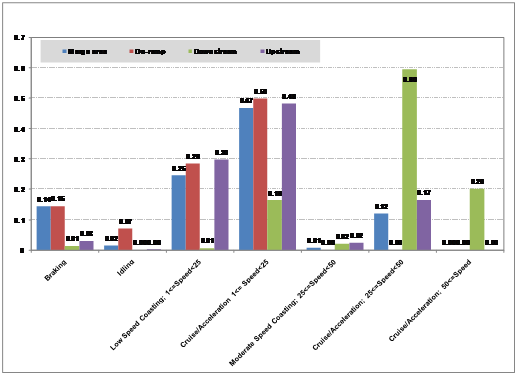
Figures II-6 through II-9 show the operating mode distributions for the On-Ramp, Freeway to Freeway Interchange, Freeway Incident, and Signalized Arterial scenarios. Each of these figures illustrates the data simulating a V/C ratio of 1.00. Figure II-10 shows the operating mode distributions for the port simulation scenario with 60 trucks per hour. As illustrated by these figures, the distribution varies significantly not only between scenarios, but also among a scenario's links.
Figure II-6. Operating Mode Distribution - On Ramp - V/C Ratio 1.00
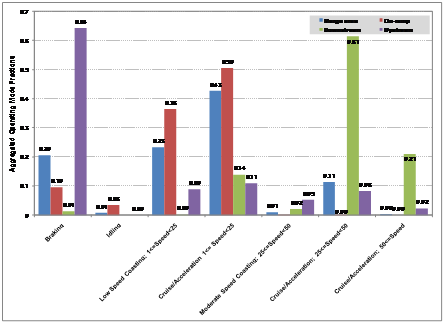
Figure II-7. Operating Mode Distribution - Freeway to Freeway Interchange - V/C Ratio 1.00
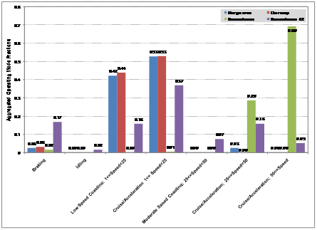
Figure II-8. Operating Mode Distribution - Freeway to Freeway Incident - V/C Ratio 1.00 - 3 Lanes Blocked
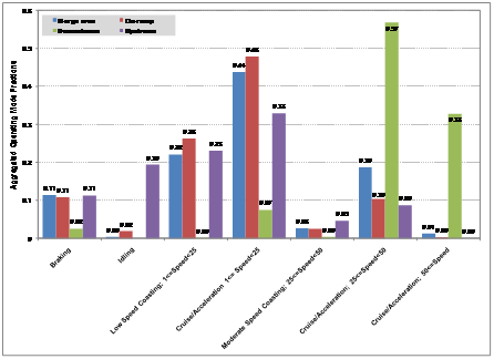
Figure II-9. Operating Mode Distribution - Signalized Arterial - V/C Ratio 1.00
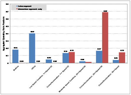
Figure II-10. Operating Mode Distribution - Intersection Approach and Approach to Port Gate (60 Trucks per Hour) and On-Port Property

Figures II-11 and II-12 are presented here to illustrate the effect that the V/C ratio has on the resulting operating mode distributions. Both figures represent the on-ramp scenario, without metering. Figure II-11 represents a V/C ratio of 0.90 while Figure II-12 represents a V/C ratio of 1.50. In the more congested condition (higher V/C ratio), there is a significant increase in the low speed coasting and cruise/acceleration and a decrease in activity at the higher speeds. This is particularly true for the upstream, ramp, and merge links. The downstream link is less affected by the change in V/C ratio.
Figure II-11. Operating Mode Distribution - On Ramp - V/C Ratio 0.90
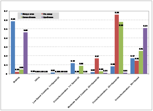
Figure II-12. Operating Mode Distribution - On Ramp - V/C Ratio 1.5