

Chapter 3. Case Studies (continued)
Maryland State Highway Administration (MDSHA)
The MDSHA is also adopting enhanced Asset Management approaches and tools. The agency has developed a Statewide business plan that includes a number of goals and measurable objectives that support the agency vision, mission, and efforts. However, many of the agency's decisions are still made within individual silos, called program funds, which deal with individual asset types (e.g., pavements, bridges, storm water management facilities, etc.). At present, MDSHA does not evaluate tradeoffs among different types of assets in terms of these decisions being data driven or based upon quantifiable outcomes.
The level to which the agency has assessed the information needed to support the identified business processes varies by fund (asset type). The Asset Management steering committee has prioritized the funds and identified six that are currently being analyzed in detail. The inventory and condition data needed for these funds are currently under review. The discussion for this investigation will focus on two of these funds: pavements and storm water management facilities.
The agency spends approximately $1 billion per year in the capital program (including major capital improvements and preservation). The system preservation component accounts for approximately 40 percent ($400 million) of these funds. In addition, the agency spends approximately $200 million per year in its maintenance program, excluding winter maintenance activities.
Overview of the Pavement Management System
The MDSHA started to develop and implement an optimization-based approach for pavement management in 1997. This model follows a two-step process:
- The pavement division in the Central Office develops network-level investment strategies that meet predefined agency objectives.
- The engineering districts select individual projects in accordance with the recommendation of the selected network-level strategy.
Table 9 summarizes the main decisionmaking levels identified from the materials provided by MDSHA.
| Decisionmaking level | Definition |
|---|---|
| Strategic Level | Decisions regarding key program performance objectives, including percentage of roads with an acceptable ride quality, percentage of Maryland's National Highway System mileage with acceptable ride quality, and average service life of State Highway Administration pavements. |
| Program Level | Development of strategies for investment that meet a deined objective such as maximizing condition or minimizing costs. The strategy provides direction in how to invest in the pavement network. |
| Project-Selection Level | Selection of individual roadway projects by district to match up against the strategy. |
| Project-Design Level | Detailed project-level design subject to the treatment level and project costs deined in the previous level. |
Maryland's pavement preservation program is developed annually based on the budget allocation established in Maryland's 6-year transportation program. The pavement management system has been used to coordinate MDSHA's pavement management practices among districts and to develop several performance-based pavement preservation plans. The core processes of this program are: performance monitoring, model development, network optimization, project selection, funding approval, pavement design, and construction and maintenance.
All pavement management planning and pavement design efforts are conducted centrally within the pavement division of the Office of Materials and Technology with funding and project selection approved through the Office of the Chief Engineer. The seven engineering districts recommend projects to be considered in the annual system preservation program and manage the construction and maintenance operations within the district.
Core Asset Management Business Processes
The following core processes have been identified in the pavement management process:
- Performance monitoring: Ride quality, rutting, cracking, and friction condition data are collected by the State (and provided to districts for project selection). Data collection decisions are mainly based on history and experience.
- Model development: The pavement division (Central Office) has developed both probabilistic and deterministic models to predict the future pavement performance when each major treatment is applied to a pavement. Whereas the probabilistic models are used to support the forecasting and planning analyses needed at the network level, the deterministic models are used at the project level. The two kinds of models have been developed to produce consistent predictions. All the prediction models are updated annually.
- Network optimization: The optimization process identifies optimal investment strategies to meet the performance objectives defined by the analyst (i.e., have 82 percent of the roads in acceptable ride condition). The MDSHA pavement network is organized into groups according to pavement type, traffic level, road type, road class, district, last major treatment level, and condition state (up to 5,040 groups). The output of the optimization is the percentage of each group that should receive each level of treatment.
The optimization runs for multiple years (typically 5, 10, or 15 years) to evaluate the long-term consequences of the plan. The optimization runs are conducted by the pavement division and produce several investment strategies. The Chief Engineer's Office selects one of the optimization runs to develop the system preservation plan. The target number of lane-miles to be treated, available budget, and expected benefits are then communicated to each district. The benefit of treatment is calculated as the increment in the area below the performance obtained as a result of applying the rehabilitation treatment.
Figure 11. Screen capture of the project selection tool developed by MDSHA. 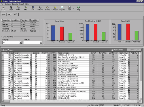 |
- Project Selection: Each district is responsible for selecting the candidate paving projects to meet the three goals defined by the optimization process: lane-miles, budget, and benefits. A software package developed by MDSHA, project selection tool (PST, figure 11), assists the districts in the project selection process. The program is also used to ensure that the final system preservation program meets the goals of the plan.
The district engineers typically organize a van tour of the network within their jurisdictions and generate a candidate project list. Then they work with the pavement division to verify the project attributes by conducting a windshield site survey by reviewing the digital roadway video logs and by checking with information in the databases. After the preliminary list is obtained and relative attributes are confirmed, the district engineers use the PST to estimate project costs by calculating preoverlay repairs and designing an overlay thickness by following the 1993 AASHTO design guidelines. The PST cost calculations include nonpaving costs for items such as guardrail improvement, contingency costs (a safety factor when the cost estimate is fairly uncertain), and administrative costs for construction management and inspection.
The program allows the district to change the year for a project, the scope of the project (i.e., select a treatment that increases the pavement life by 8 years instead of 12 years), verify costs, change unit prices, etc. The districts select projects for funding to attend to the needs identified while achieving the line-mile, budget, and benefit goals established by the network-level analysis. - Funding approval: After the districts select projects for funding, the Chief Engineer's Office reviews the projects using the PST program and determines if each project will receive funding for design and construction. The Chief Engineer's Office may add projects not submitted by the district.
- Pavement design: After the project is approved for funding, it moves into the project-level phase. The final pavement design for each project has to be consistent with the treatment selected noted in the previous steps. The pavement division designs a rehabilitation alternative that meets or exceeds the design life defined by the treatment level and that does not exceed the paving costs of the project defined in the PST program.
- Construction/maintenance: The engineering districts are responsible for managing the construction and maintenance operations within their respective areas.
Project Selection
In the project selection process, the treatments applied to any of the pavement groups are categorized into seven groups on the basis of their life expectancy. The treatment groups are 15, 12, 8, 5, +4, and +2 years, as well as "do nothing." The first four treatment groups (5-15 years) are considered major rehabilitation alternatives that effectively reset the pavement to an original condition. The treatment groups of +4 and +2 years are considered maintenance treatments and are intended to reflect corrective or preventive maintenance strategies that maintain existing conditions or correct only a portion of the pavement and do not reset the pavement to an original condition. The treatment level group was created to reflect differences in performance and cost of rehabilitation improvements and to allow setting constraints that would force a minimum or maximum level of funding in each treatment level group.
Data Collection
The MDSHA collects both network- and project-level pavement condition data. The type and amount of data collected are selected on the basis of the requirements of the business plan, engineering judgment, and safety consideration.
The MDSHA annual network-level data collection includes ride quality, rutting, and friction for all directional miles under the responsibility of MDSHA (100 percent coverage). These data are collected using automatic data collection equipment: an automated roadway analyzer (ARAN) vehicle from Roadware, and a locked-wheel skid tester. The ARAN vehicle collects ride quality, rutting, right-of-way digital video, and downward digital video for automated cracking identification. The network-level distresses are summarized in pavement condition indexes (e.g., smoothness, rutting, and cracking) that are normalized to a scale of 0-100. Each roadway section is classified into condition states (A, B, C, D, or E) based on these indexes. The cost of collecting these data is approximately $40 per mile.
The project-level data collection includes pavement material structure and thickness determination, nondestructive deflection testing, and ride-quality testing. These data are collected using a high-speed profiler, a falling weight deflectometer (FWD), ground-penetrating radar (GPR), drilling/coring rigs, and manual visual surveys (using the PAVER pavement condition index [PCI]).
Data Management
The data contained in the PST program are integrated with the MDSHA pavement management database. Three sources of data are merged to create the PST roadway section data:
- Roadway inventory database: This database contains information on the roadway geometry, designation, and traffic. This data is referenced at 0.1-mile intervals.
- Pavement performance database: This database contains ride quality, rutting, cracking, and friction condition data. This data also is segmented at 0.1-mile intervals.
- Construction history database: This database contains records that identify every layer in the pavement structure including construction, material type, and thickness data. The data is segmented in various lengths based on consistent construction history and typically varies between 0.1 and 2 miles in length.
To create the roadway section data for the project selection program, the data from these three sources are merged and aggregated to provide summary information at the intervals defined in the construction history database.
Overview of the Drainage and Storm Water Facility Management System
The MDSHA uses a national pollutant discharge elimination system (NPDES) to manage drainage and storm water facilities within its jurisdiction. The initial motivation of the NPDES program was to assist in addressing drainage complaints from communities and to meet NPDES regulatory requirements. The highway hydraulics division began managing storm water facilities in 1982. Before the inventory process started, complaints were received by SHA through phone messages, emails, and meetings and were addressed with quick site designs and fixes. The new system allows MDSHA to collect data and manage the facilities more efficiently.
The NPDES is a large program involved in everything from the development of the database to the design of the drainage facilities. MDSHA's NPDES program was conceived as a two-phase Statewide program to address the MDSHA need for managing drainage structures and storm water facilities. The agency must identify, inspect, and maintain the hydraulic access facilities not managed by other divisions to ensure performance and public safety. Other divisions manage larger hydraulics facilities such as bridges. The focus is on storm water management facilities; however, culverts and other drainage features are being added in updates to the drainage inventory and condition assessment.
Core Asset Management Business Processes
Although the division has not formally identified separate business processes, the following processes are key for supporting decisionmaking:
- Inventory: NPDES inventory process was initially a separate process, but it is now being coordinated with MDSHA's permit process. The inventory is stored using a GIS platform and a relational database developed using Microsoft Access.
- Project selection and scoping: The division selects a strategy ("do nothing," "maintenance," or "rehabilitation") for each facility on the basis of the inventory and condition information. On-call contractors conduct routine maintenance through work orders. If the problem requires designs, the division creates a project similar to any other State project.
- Execution of the recommended projects: The projects are outsourced.
Project Selection
The highway hydraulics division expends approximately $13.5 million each year managing hydraulic facilities. It uses open-ended contracts to maintain the facilities, which includes the actual design of the proposed solution. The open-ended contracts were found to be the cheapest and fastest approach to address needs. Routine performance and response inspections are performed every 3 years. If the ratings of the initial inspections suggest that more than maintenance is needed, then a second inspection is performed to confirm such decisions. Project selection decisions are made by the Central Office based on most-dangerous conditions and highest priority. If the need for remediation or retrofit is confirmed by the second inspection, a more formal evaluation is conducted on the basis of expert opinion.
Data Collection
The MDSHA's NPDES started a pilot to inventory hydraulic facilities in 1999. As part of the inventory process, the agency hired contractors to reference each individual node using GPS. These inspectors conduct the initial inspection of the facility. A second inspection is triggered if the performance-based rating is a 4 or 5.
Originally, MDSHA developed the inventory using available plans; however, the process has evolved, and the data are currently verified in the field. Inspectors take the plans to the field, locate the facilities again, and reference their location using GPS. The agency has prepared a detailed inspection manual for engineers to use when they assess these facilities.
The condition of the storm water management facilities is evaluated periodically by using two rating systems:
- Performance-based rating: This is a performance evaluation of facilities for functional and structural integrity. Each facility is rated according to 45 items using a subjective 1-5 scale.
- Response rating: This provides an estimate of the level of work required (how the structures will be maintained) and the priority for maintenance and remediation. The facility receives an overall inspection rating from A (no action required) to E (facility failed, hazardous conditions). Facilities with a rating of C or below are candidates for remediation.
Small drainage structures are added when possible. While inspectors collect GPS data (inventory) on the facility they can easily take a picture and provide a brief rating. Given the number of these facilities (hundreds of thousands), the agency cannot afford to inspect these smaller drainage systems on a regular basis. Most of the storm drainage networks are under the roadways and require video inspections because it is hard to get people into some of these facilities.
For example, in Baltimore County, MDSHA inspected 2,500 out of 4,000 structures and rated them by using a scale from 1 (best) to 5 (worst). Less than 10 percent of them were rated as a 4 or 5. The condition data are linked with NPDES data and the overall GIS inventory.
Decisions regarding what data to collect are based on an inspection manual that the MDSHA developed in 1999 to inspect storm water management facilities. No revisions to the manual have been made since its first release. This manual lists 45 items to be inspected for both project selection and project design. The agency also has a design manual that has been updated twice: once in 1980 and again in 2000.
Although there are no precise records about the cost of the various activities, MDSHA was able to provide some estimates. The storm water management division spends approximately $1 million on data collection (inventory and inspection) per year. The data collection cost was approximately $500,000 for the collection of the initial inventory data for one county; however, updating the information the second time was cheaper by approximately half of the initial cost. The most cost effective data collection procedure uses handheld PDAs and GPSs.