

| << Previous | Contents | Next >> |
Relationships Between Asset Management and Travel Demand:
Findings and Recommendations from Four State DOT Site Visits
2.1 Introduction
Over the past decade, state DOTs have increasingly adopted TAM practices as a means of better managing the condition and performance of their highway infrastructure. Over the same period, states have also experienced unprecedented levels of roadway congestion and travel delays - the result of decades of continuous growth in travel demand. The objective of this study is to determine how state DOTs are applying the methods and objectives of TAM as a means of addressing sustained travel demand growth and its impacts on highway infrastructure needs and performance.
This chapter has two objectives. First, it provides a brief overview of TAM as it is currently defined in the U.S. transportation community, including its principles, objectives, and techniques. Second, it provides a review of recent and long-term trends in U.S. highway travel demand (both for private autos and commercial vehicles), highway capacity, congestion, and travel delay costs.
Given this background, the succeeding chapters of this report focus on how a sample of four U.S. state DOTs are applying asset management principles (either explicitly or implicitly) to address the challenges related to ongoing growth in travel demand. Specifically, Chapter 3 describes both the specific questions to be addressed by this study and the approach used to answer those questions. It also provides a comparative analysis of the four states selected for the study: California, Michigan, North Carolina, and Utah. Chapter 4, the core of the report, provides an overview of the current asset management programs of all four states as well as their current travel demand capabilities. It also examines how these two capabilities are being jointly used to address short- and long-range travel demand issues. Chapter 5 examines SLRPs and long-range budgeting, their potential roles as part of the TAM process, and their roles in addressing travel demand issues. Finally, Chapter 6 summarizes the conclusions of this report and presents recommendations - both to FHWA and to state DOT staff - on potential future improvements to federal and state practices.
2.2 Adoption of TAM
TAM is a strategic approach to managing transportation infrastructure. It focuses on business processes for resource allocation and utilization with the objective of better decision-making based upon quality information and well-defined objectives. It includes strategic approaches to inventorying, monitoring, investing, and managing, at desired levels of performance, the many different assets that constitute a transportation system, and it provides a framework for the efficient allocation of resources by transportation agencies. Transportation assets range from physical infrastructure to information to human capital. Fully implemented transportation asset management leads to better-informed investment decision making and has the potential to reduce the gap between increasing investment requirements - driven by population growth, economic growth, and socioeconomic changes - and available financial resources.
TAM methods have been widely deployed in several other developed countries - including Britain, Canada, New Zealand, and Australia - for more than two decades. Although a more recent phenomenon in the U.S., TAM has become widely adopted over the past decade with virtually all state DOTs now practicing some form of asset management, most typically in the form of pavement, bridge, maintenance, and safety management systems. In addition, many states are now moving beyond these "baseline" management systems for assets to embrace the wider definition of asset management as provided in the preceding paragraph. Specifically, some agencies have implemented or are working to implement one or more of the following asset management techniques/functions:
- Identification of agency-wide goals and objectives
- Development and maintenance of comprehensive asset inventories (including pavement, bridges, signs, signals, guard rails, rest areas, drainage, etc.)
- Completion of ongoing system condition and performance assessments
- Development and implementation of investment tradeoff tools (not just within a given asset type but between asset types; sub-regions; and preservation, expansion, safety, and operational investments)
- Monitoring of a set of key performance measures.
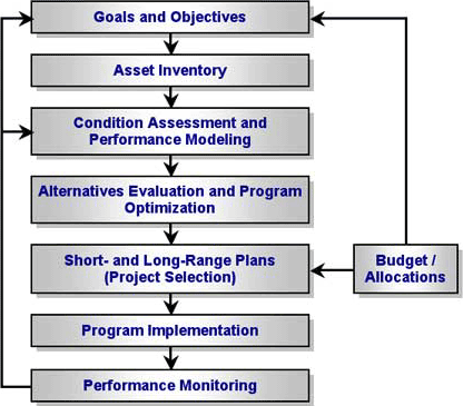
The relationship between these and other asset management functions is outlined in Exhibit 2-1.
Exhibit 2-1: Primary TAM functions and their relationships (Description)
FHWA believes that, as a relatively new initiative in the U.S. transportation community, a demonstration of current TAM practices at a sample of state DOTs will prove useful to other transportation organizations working to implement or improve their own asset management programs. Therefore, one objective of this study is to document the current TAM practices used by a sample of four U.S. state DOTs. Given the study's focus, the primary study objectives are to document how travel demand measures are being used as inputs to TAM processes (e.g., how do current measures of truck VMTs impact pavement preservation needs?), and how TAM processes are being used to impact the outcome of travel demand-related issues (e.g., congestion). Note here that both current and projected travel demand measures are inputs to TAM processes, while the potential to mitigate travel demand-related problems is an output of the TAM process.
2.3 Trends in Highway Capacity and Travel Demand
Over the past 25 years, the nation's population, economy, and vehicle ownership have all grown much faster than total highway lane-miles - a fundamental measure of highway capacity. From 1980 to 2004, population increased at an average annual rate of 1.06 percent, the gross domestic product (GDP) grew at an average annual rate of 3.11 percent, and the number of vehicles increased at an average annual rate of 1.68 percent. Total highway lane-miles, on the other hand, increased at an average annual rate of only 0.21 percent from 1980 to 2003. Furthermore, population is expected to increase at 0.88 percent per year from 2004 to 2015 (from 292 million to 321 million), and the economy (measured by GDP) is expected to grow at 3.09 percent per year in the same time period. Exhibit 2-2 indicates a clear divergence between the increasing demands for transportation services and nearly static highway capacity. Without a dramatic increase in capacity investment, this diverging pattern will undoubtedly continue.
There is also a divergence between highway usages and highway capacity. From 1990 to 2003, passenger-miles traveled (PMT) increased at an average annual rate of 2.20 percent, VMT increased at an average annual rate of 2.32 percent, and truck ton-miles increased at an average annual rate of 3.06 percent. During the same period, total highway lane-miles increased at an average annual rate of only 0.25 percent. Passenger cars and other 2-axle, 4-tire vehicles together account for well over 90 percent of both total highway PMT and VMT over the last two and a half decades. Exhibit 2-3 shows the divergence between the growth of highway usages and that of highway capacity. Among the three measures, truck ton-miles had the fastest growth, which was the result of a sustained increase in the share of truck ton-miles in the total ton-miles of freight in the U.S. In the 1990s, trucks accounted for less than 24 percent of U.S. total ton-miles of freight, but maintained a sustained growth to over 29 percent of U.S. total ton-miles of freight in 2003 (see Exhibit 2-4). Despite the rise of air passenger transportation, from less than 3 percent of U.S. total PMT in 1960 to over 10 percent in the 1990s, highway PMT still accounted for 89 percent of total U.S. PMT in 2003.
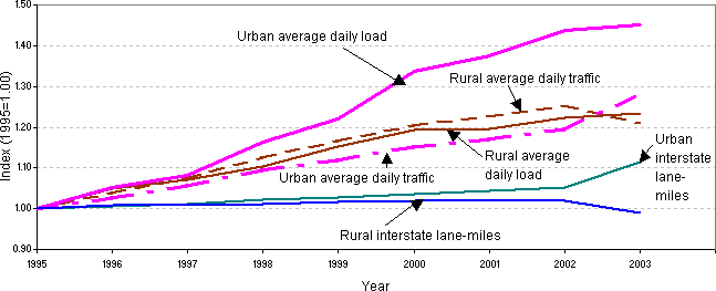
Measured by average daily load and average daily traffic, the increase of highway usage intensity on the interstate system greatly outpaced the growth of interstate lane-miles in both urban and rural areas (Exhibit 2-5). Note that the decline of lane-miles in rural areas and the accelerated growth of lane-miles in urban areas may be due to the reclassification of rural into urban interstate functional systems due to the expansion of urbanized areas.
Exhibit 2-2: Growth of population, GDP, vehicles, and total highway lane-miles 2 (Description)
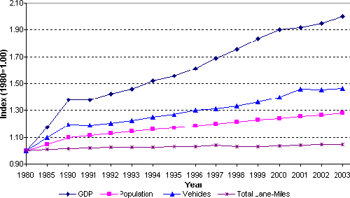
Exhibit 2-3: Growth of PMT, VMT, truck ton-miles, and total highway lane-miles 3 (Description)
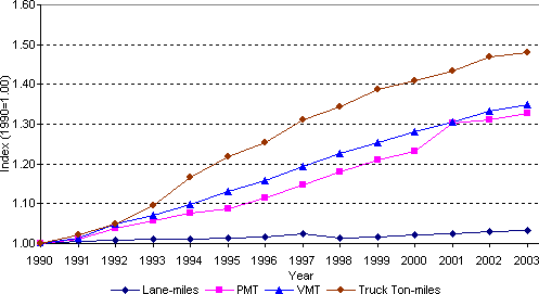
Exhibit 2-4: Growing share of truck ton-miles as percentage of total U.S. freight ton-miles 4 (Description)
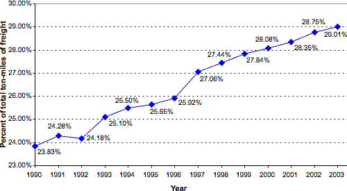
Exhibit 2-5: Growth in capacity, volume, and loadings on the Interstate system (Index: 1995=1) 5 (Description)
The sustained population and economic growth and rapidly increasing highway usage have put great pressure on the highway system. There is a divergence of road pavement conditions between rural and urban areas and across highway functional systems. While road pavement conditions in rural areas have improved, road pavement conditions in urbanized areas have actually worsened. In rural areas, the average share of total mileages in acceptable and good conditions increased from 86.2 percent in 1995 to 91 percent in 2002, and the share of mileages in good condition increased from 44.7 percent to 50.9 percent. In small urban and urbanized areas, however, the average shares of both acceptable and good condition mileages declined in the same period. The percentage of total mileage in acceptable condition declined from 81.7 percent to 80.6 percent in small urban areas, and from 81.7 percent to 75.9 percent in all urbanized areas.
In 9 of the 14 highway functional classifications, there was an increase in the percentages of mileage in acceptable conditions from 1995 to 2002. Over 90 percent of all interstate highways in both urban and rural areas were in acceptable conditions. However, the percentages of road mileage in acceptable condition declined in five other highway functional classifications, which included small urban minor arterials, small urban collectors, urbanized other principal arterials, urbanized minor arterials, and urbanized collectors. For example, the acceptable mileages of urbanized, other principal arterials declined by over 8 percentage points, from 75.9 percent in 1995 to 67.5 percent in 2002.
The divergence of road pavement conditions across highway functional classifications is even clearer when the percentages of mileage in good condition are compared. Only 7 of the 14 highway functional classifications had an increase in the percentages of mileage in good conditions. Seven other highway functional classifications had declining shares of mileages in good conditions. All these declining highway classifications were at lower levels, including rural major collector, small urban other principal arterial, small urban minor arterial, small urban collector, urbanized other principal arterial, urbanized minor arterial, and urbanized collector. The largest declines were in urbanized collector (10.9 percentage points), rural major collector (10.6 percentage points), and small urban collector (10.3 percentage points). In 2002, less than one quarter of urbanized other principal arterial and only about one-third of small urban collector and urbanized collector miles were in good condition. Clearly, urban areas are facing greater challenges in improving their road pavement conditions.
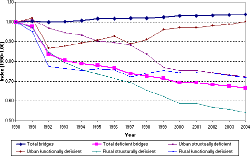
Overall, the conditions of the nation's bridges have largely improved while the total number of bridges has increased. The total number of deficient bridges decreased from 238,220 in 1990 to 158,319 in 2004 (i.e., a decrease of 34 percent). The improvement of bridge conditions is attributed to the improvement in the decline of rural deficient bridges and in the decline of urban structurally deficient bridges (Exhibit 2-7). However, urban functionally deficient bridges increased by over 15 percent in more than a decade, from 26,243 in 1992 to 30,298 in 2004 (Exhibit 2-6).
Exhibit 2-6: Urban functionally deficient bridges in 1990-2004 6 (Description)
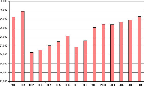
Exhibit 2-7: Growth of total and deficient bridges, 1990-2004 7 (Description)
Urban areas face greater challenges and more severe problems. Urban and rural VMT per lane-mile increased from 1990 to 2003 by 12 percent and 28 percent, respectively. Nevertheless, the intensity of highway usage is far greater in urban areas than in rural areas, although the difference declined from about 5 times greater in 1990 to 4 times greater in 2003 (Exhibit 2-8).
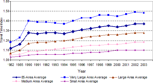
Urban congestion has worsened over the last two decades across urbanized areas of all sizes. Average annual delay per traveler in peak hours grew from 16 hours in 1982 to 47 hours in 2003.8 Roadway congestion indices and travel time indices continued to increase in the last two decades. For the 85 urbanized areas surveyed, the average roadway congestion index rose from 0.81 in 1982 to 1.17 in 2003, which means roadway traffic volume increased from below roadway capacity in 1982 to exceeding roadway capacity by 17 percent in 2003 (Exhibit 2-9). The travel time index increased from 1.12 in 1982 to 1.37 in 2003, which means that a 20-minute, free-flow trip took 22.4 minutes in the peak hours in 1982 and 27.4 minutes in the peak hours in 2003 (Exhibit 2-10). In 2003, urban congestion resulted in a total of 3.7 billion hours delay and 2.3 billion gallons of wasted fuel, which cost a total of $63.1 billion.
Safety is always of great concern in transportation. Although the fatality rate per 100,000 VMT is dropping, the total number of accidents has not decreased. As a result, it is difficult to determine through crash rates alone whether increasing VMT have positive or negative impacts on safety.
Exhibit 2-8: Urban and rural VMT per lane-mile 9 (Description)
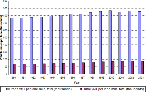
Exhibit 2-9: Roadway congestion index 10 (Description)
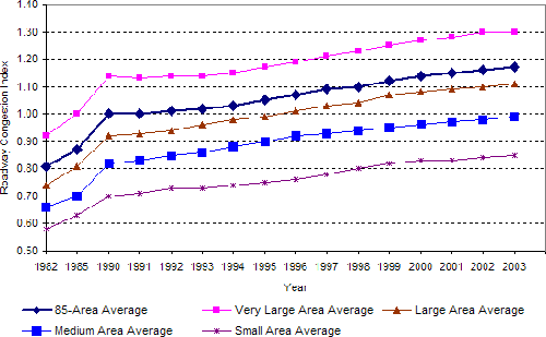
Exhibit 2-10: Travel time index 11 (Description)
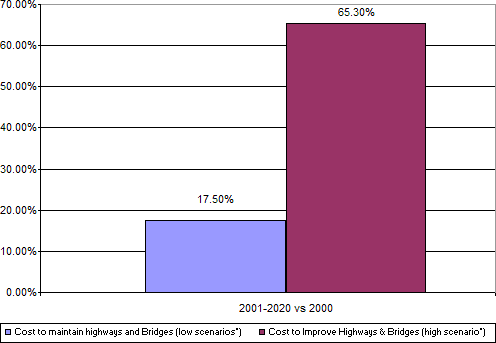
Increases in demand for transportation services, continuing increases in highway usage intensity, worsening roadway congestion, increases in travel times, and limited resources for investment in highway maintenance and improvement together pose great challenges for transportation agencies. Considering economically justified investment, projected spending requirements are far above the levels of current spending on highway maintenance and improvement. The gap between projected investment requirements and current spending is very large in the future (Exhibit 2-11). From 2001 to 2020, just to maintain highways and bridges would require annual spending to be 17.5 percent higher than current levels of spending, and to improve highways and bridges would require an annual investment that is 65.3 percent higher than current annual spending.
Exhibit 2-11: Projected investment requirements versus current spending 12 (Description)
2.4 Summary
This study is focused on how state DOTs are managing their assets in recognition of the expected significant growth of VMT and truck freight movements over the next two decades. The asset management practices of four state DOTs are documented here, including how they manage their financial and infrastructure resources to address and plan for the projected increases in demand on their transportation system. Examples of good asset management practices are included to demonstrate how state DOTs are setting priorities to address capacity and deterioration deficiencies resulting from the expected substantial increases in demand and aging facilities.
Notes
- Population data are from U.S. Census Bureau, Statistical Abstract of the United States, 2004-2005. GDP is from Bureau of Economic Analysis, "National Income and Product Account Tables," Table 1.1.6, available at http://www.bea.gov/bea/dn/nipaweb/SelectTable.asp?Selected=3, December 2005; and U.S. Congressional Budget Office, The Budget and Economic Outlook, August 2005. Data on vehicles and total highway lane-miles are from Department of Transportation, National Transportation Statistics 2005 as of December 9, 2005. Back to text.
- Sources: Data is from, Department of Transportation, National Transportation Statistics 2005, as of December 9, 2005. Back to text.
- Department of Transportation, National Transportation Statistics 2005. Back to text.
- Loadings are based on equivalent axle loads that are the damage to a pavement caused by a vehicle axle relative to an 80 kN (18,000lb) force that represents a standard single axle. Source: Based on data on daily traffic volume and load from Federal Highway Administration, Highway Statistics 2003, at https://www.fhwa.dot.gov/policy/ohim/hs03/htm/tccht.htm. Data on interstate lane-miles are from Department of Transportation, National Transportation Statistics 2005. Back to text.
- Note: Functionally deficient bridges are defined as those that do not have the lane widths, shoulder widths, or vertical clearances adequate to serve traffic demand, or that may not be able to handle occasional roadway flooding. Source: Department of Transportation, National Transportation Statistics 2005. Back to text.
- Note: Structurally deficient bridges are defined as those needing significant maintenance attention, rehabilitation, or replacement. Source: Department of Transportation, National Transportation Statistics 2005. Back to text.
- Texas Transportation Institute, The 2005 Urban Mobility Report, May 2005. http://mobility.tamu.edu. Back to text.
- Department of Transportation, National Transportation Statistics 2005. Back to text.
- Note: The roadway congestion index (RCI) is a measure of vehicle travel density on major roadways in an urban area. An RCI exceeding 1.0 indicates an undesirable congestion level, on average, on the freeways and principal arterial street systems during the peak period. The urban areas included are those containing over 500,000 people and several smaller places mostly chosen by previous sponsors of the Texas Transportation Institute study on mobility. Source: Department of Transportation, National Transportation Statistics 2005. Back to text.
- Note: The travel time index (TTI) is the ratio of peak-period travel time to free-flow travel time. The TTI expresses the average amount of extra time it takes to travel in the peak relative to free-flow travel. A TTI of 1.3, for example, indicates a 20-minute, free-flow trip will take 26 minutes during the peak travel time periods, a 6-minute (30 percent) travel time penalty. Source: Department of Transportation, National Transportation Statistics 2005. Back to text.
- Federal Highway Administration: 2002 Status of the Nations' Highways, Bridges, and Transit: Conditions & Performance. Back to text.
| << Previous | Contents | Next >> |