


August 29, 2019
Innovation of the Month:
Unmanned Aerial Systems
Through the month of August, we have shown you how unmanned aerial systems (UAS) enhance structural and construction inspection programs and how they are being used across the country in emergency response. UAS have also increased efficiency when used with other innovations such as e-Construction, and when supporting critical activities.
The Montana Department of Transportation (MDT) uses UAS with e-Construction to measure and maintain stockpiles through a cloud-based platform that easily integrates UAS-captured photos. MDT reports UAS are able to capture data on road segments up to three-quarters of a mile in length including more than 20 stockpiles in a single pass. MDT's cost analysis determined UAS stockpile reports are approximately one-tenth the cost to prepare per site compared to a GPS topographic survey.
MDT also uses UAS for photo and video documentation to aid maintenance crews. The yearly snow accumulation at the Beartooth Highway, the northeast gateway into Yellowstone National Park, poses extreme risks to plow operators due to potential avalanches. UAS technology gives the State a safe way to identify potential avalanche areas and better estimate the effort necessary to clear the road.
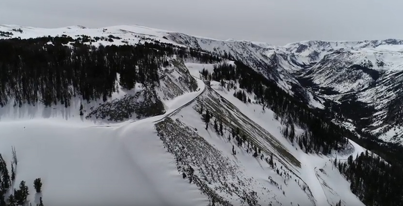
Credit: MDT
To learn more about how your State can use UAS, please contact James Gray with the FHWA Office of Infrastructure or John Haynes of the FHWA Utah Division.
Minnesota Integrates DDSA into Business Practices
The Minnesota Department of Transportation (MnDOT) has integrated two data-driven safety analysis approaches, systemic and predictive analysis, into its routine business practices.
MnDOT updated its district safety plans using systemic data analysis. The systemic approach evaluates risk across an entire roadway network and identifies locations that are at high risk for serious crashes. Systemic analysis is more proactive than traditional methods because it lets agencies install cost-effective safety countermeasures at multiple locations based on future risk, sometimes before crashes happen. MnDOT is now working with Minnesota counties to include systemic analysis in their local agency roadway safety plans.
Focusing on predictive analysis, MnDOT published a Performance-Based Practical Design guidance document, which emphasizes use of the AASHTO Highway Safety Manual to inform decisions. The agency made crash modification factors (CMFs), which calculate expected number of crashes after implementing safety countermeasures at a site, standard practice to quantify benefits of spot location safety projects. MnDOT's next step is to develop State-specific CMFs to better quantify benefits and costs for Highway Safety Improvement Program projects.
To learn how your State can use predictive and systemic data analysis to improve roadway safety, please contact Jerry Roche with the FHWA Office of Safety or John McFadden with the FHWA Resource Center.
Reducing Rural Roadway Departures Team Releases Training Trading Card Set
Are you looking to enhance your reducing rural roadway departure training materials? The focus on reducing rural roadway departures (FoRRRwD) team published a set of 18 trading cards that illustrate rural roadway departure crash types, countermeasures, and tools. Transportation agencies are encouraged to use these cards in their own meetings to educate staff on various approaches to reduce rural roadway crashes and save lives.
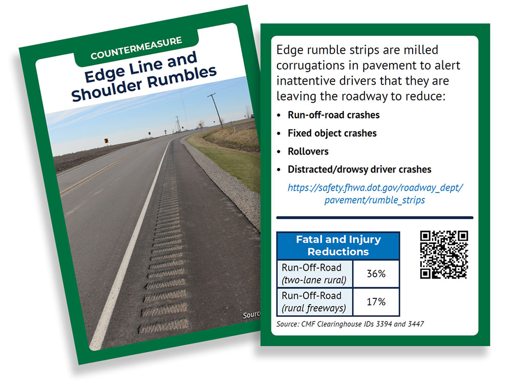
These popular cards are now available in three print-ready versions on a new web page so you can continue to share information on FoRRRwD in a variety of settings.
To learn more about reducing rural roadway departures in your State, please contact Cate Satterfield with the FHWA Office of Safety or Dick Albin with the FHWA Resource Center.
About EDC
Every Day Counts, a State-based program of the Federal Highway Administration’s Center for Accelerating Innovation, works with State, local, and private sector partners to encourage the adoption of proven technologies and innovations to shorten and enhance project delivery.