
States Innovate
States Use Crowdsourced Data to Improve Real-Time Roadway Monitoring
State transportation agencies are demonstrating the value of crowdsourcing for operations. The Tennessee Department of Transportation (TDOT) used crowdsourced data to detect crashes and stopped vehicles faster. In conjunction with the University of Tennessee, TDOT used Waze speed, incidents, and traffic jam data to enhance queue detection techniques that previously relied on traditional intelligent transportation system (ITS) roadway sensors. Adding crowdsourced data greatly expanded the geographic coverage area and timeliness of TDOT’s queue detection and response capabilities. The crowdsourced data enabled TDOT to identify the backs of queues 1.1 minutes faster on average than by just using ITS vehicle detectors and monitoring cameras at fixed locations.
By joining the Waze Connected Citizens Program (CCP), the Maryland Department of Transportation (MDOT) can more effectively share road closure incidents in real time with users of the application. MDOT has also begun archiving and analyzing crowdsourced data available through the CCP partnership for its potential to complement the agency’s robust traffic monitoring systems. Findings from data verification efforts are confirming the value of investing in this new data source. MDOT expects analyses will inform future ITS infrastructure deployment, while real-time information will help more quickly detect and respond to incidents on freeway and arterial facilities.
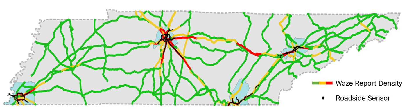 Using crowdsourced data expanded the coverage of the Tennessee Department of Transportation’s queue detection and response capabilities.
Ohio Township Safety Sign Program Reduces Crashes
Because 40 percent of rural roadway departure crashes occur on locally owned roads, many State transportation agencies are helping local agencies reduce rural roadway departures. The Ohio Department of Transportation (ODOT), with assistance from the Ohio Local Technical Assistance Program, administers the Township Safety Sign Grant Program. This systemic curve signing upgrade program helps ODOT reach the 84 percent of roads not on the State highway system. Townships with a greater-than-average crash rating over the previous 5 years are eligible to apply for up to $50,000 each in safety sign materials with no required local match. From 2015 to 2019, more than 225 townships participated in the program. An evaluation of crash data in 24 townships that installed signs in 2015 showed a 67 percent reduction in fatalities and 33 percent drop in serious injuries in the 2 years after deployment, compared to statewide crash increases in fatalities of 9 percent and injuries of 11 percent.
Pennsylvania Data Show Crashes Drop at Roundabouts
Pennsylvania Department of Transportation (PennDOT) data show that fatalities, injuries, and crashes decreased overall at 22 roundabouts built at 19 locations that were previously stop or signal controlled. The agency evaluated roundabouts with at least 3 years of crash data available before and after the roundabouts were built. The data show that fatalities at these locations were reduced by 100 percent, serious injuries (as defined by the U.S. Department of Transportation’s Model Minimum Uniform Crash Criteria) dropped by 77 percent, and the total number of crashes decreased by 21 percent. In addition to the 22 roundabouts reviewed, PennDOT has built 34 other roundabouts and has over 40 more in design. PennDOT created a video to educate road users on how to use roundabouts, whether in a vehicle, on a bicycle, or on foot.
Unmanned Aerial Systems Save Money for West Virginia
The West Virginia Department of Transportation (WVDOT) has used unmanned aerial systems (UAS) to save money on calculating stockpile material quantities. WVDOT acquired its first UAS to test the viability of measuring stockpile material, and the State’s program has grown steadily since then to inventory 150 sites a year. Historically, this labor-intensive process involved surveyors and engineers. In 2019, the State inventoried the sites using UAS and seven pilots. WVDOT saved $340,000 in man-hours alone, and the agency estimates that overall savings were likely higher when including factors such as the surveyors and engineers being available to complete other work during the inventory.