


STICs Deploy Homegrown Innovations
Every Day Counts round six (EDC-6) kicked off with a Virtual Summit in December 2020 introducing the seven innovations FHWA is promoting in 2021 and 2022. The summit also featured a National State Transportation Innovation Council (STIC) Network Showcase that highlighted more than 200 innovations developed and deployed by agencies throughout the country. Following are just a few examples from the showcase in the areas of maintenance, emergency response, and operations.
When the town of Niles, NY, was experiencing flooding along its roadways, highway department officials found that beavers had packed the culvert under the roadway with sticks and mud. To solve the problem, they obtained unused steel baskets from another job and built a beaver pipe cage. The cage keeps beavers out of the culverts so water can flow freely. This low-cost solution also won a 2020 Build a Better Mousetrap award.
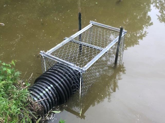
The beaver pipe cage keeps the animals from packing culverts with sticks and mud.
Credit: Town of Niles, NYThe Louisiana Department of Transportation and Development fabricated the RutBuster, a multi-use device that attaches to a skid steer loader. RutBuster is a low-cost tool for completing a variety of routine maintenance tasks quickly and efficiently, such as filling ruts in asphaltic roadway wheel paths, paving asphalt shoulders, cutting isolated high shoulder locations, and more. The agency said the RutBuster greatly increases yield and productivity during rut repairs versus using a motor grader.
A gravel-saver disc tool clears away debris and vegetation from roadsides to reduce hazards to drivers. These discs can crack or break when hit with rocks or other hard objects and can become clogged by vegetation. LaMoure County, ND, created the Spring Load Arm Enhancement as an attachment to the disc that increases its flexibility, allowing rocks and vegetation to flow more freely with less breaking and clogging. This innovation was also a 2020 Build a Better Mousetrap winner.
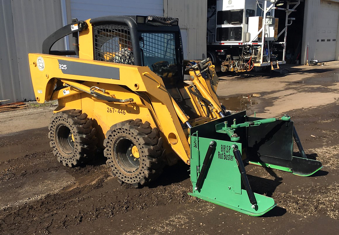
The RutBuster attachment helps fill ruts in asphaltic roadway wheelpaths quickly and efficiently.
Credit: Louisiana DOTDMaine DOT deployed a road weather temperature phone app that allows crew leaders and supervisors to enter road and weather condition data during winter storms. In the past, this data was called in and entered into the DOT’s New England Compass system manually. With the app, the data is entered from the field and automatically populated into the system, enabling it to be seen in near real time by maintenance and operations staff and by the public.
The Delaware DOT (DelDOT) implemented a crowdsourced data pothole reporting program. DelDOT developed an interface that uses crowdsourced data from Waze, including confidence and reliability scores, and filters it to report potholes on State-maintained roadways. The system creates a report, which provides precise location information via a clickable map, for the proper maintenance district and yard.
Adding crowdsourced incident data to its 511 system provided a low-cost solution for South Carolina DOT (SCDOT) that benefits users. A major overhaul to its 511 website and mobile app added crash, congestion, and hazard data from Waze along with real-time traffic speeds from HERE Technologies. This allows SCDOT to provide incident data on roadways not monitored by sensors or cameras.
The Maryland DOT operations dashboard is an internet browser-based application framework that runs on any device, enabling staff to efficiently deploy resources with access to over 60 statewide essential operational data feeds. Clicking on an incident on the dashboard zooms to its map location, and data feeds adjust dynamically to display pertinent information and live streams from roadway video feeds.
The Missouri DOT (MoDOT) is using technology that enables emergency response vehicles to warn motorists of hazards directly through navigation apps such as Waze. When an emergency response operator activates their emergency lights, real-time digital warnings are sent instantly to nearby motorists via in-car systems and phone apps. Preliminary usage data in its St. Louis District shows a 40-percent reduction in third-party crashes.
Tennessee’s TIM Training Facility enhances learning with live exercises.
Credit: Tennessee DOTThe Tennessee DOT’s Traffic Incident Management (TIM) Training Facility enabled the agency to develop and deploy advanced TIM training with full-scale live exercises. The agency reports that the TIM Training Facility has increased its maturity level and the capabilities of its partners in responding to traffic incidents, and that learning retention has greatly improved through the inclusion of live exercises.
The California DOT (Caltrans) responder system helps incident responders, especially those in remote or rural areas where communication coverage is sparse, collect and transmit at-scene information quickly and efficiently. This communications tool allows details to be shared between responders, the traffic management center, public information officers, and outside agencies during an incident using WiFi, cellular, or satellite.
The city of Wilmington, NC, found a solution to better protect drivers and police officers at four-way intersections during widespread power outages, such as after a hurricane. Typically, two rotations of four officers are assigned to these intersections. To maintain safety and free more officers for other calls, the city used traffic cones to form temporary roundabouts with one officer assigned to each. This innovation was also a 2019 Build a Better Mousetrap competition winner.
Wilmington, NC, implemented temporary roundabouts at several intersections during widespread power outages after a hurricane.
Credit: City of Wilmington, NCPurdue University’s Joint Transportation Research Program (JTRP), operated in collaboration with the Indiana DOT, demonstrated the value of drones for photogrammetric crash scene documentation. The JTRP reported that drones, also called unmanned aerial systems (UAS), produce high-quality scaled maps and facilitate significantly faster scene clearance than terrestrial mapping, reducing public safety personnel’s exposure to traffic hazards and the likelihood of secondary crashes.
—MORE INFORMATION
Download the Homegrown Innovations spreadsheet from the FHWA website for more information on these and other innovations developed and deployed by State and local agencies across the country.
Recommended Citation: U.S. Department of Transportation, Federal Highway Administration - Washington, DC (2021) Innovator Newsletter, November/December 2021, Volume 15 (87). https://doi.org/10.21949/1521365