


States Innovate!
States Employ Digital Drill Rigs
As part of a project to widen and improve a major corridor, the New Hampshire Department of Transportation (NHDOT) instrumented a rig to use Measurement While Drilling (MWD), an advanced geotechnical methods in exploration (A-GaME) technology, to better understand the engineering properties of the soil and rock. The agency is using MWD on this project to enhance geotechnical site characterization and provide continuous, real-time monitoring and recording of data during the drilling process. NHDOT’s in-house mechanical services staff instrumented a conventional rig with sensors to measure and record parameters including torque, downward thrust, rotational speed and penetration rate. A readout on the rig allows for real-time monitoring that relates to the effort needed to penetrate the ground. Read more about this project in the A-GaME newsletter.
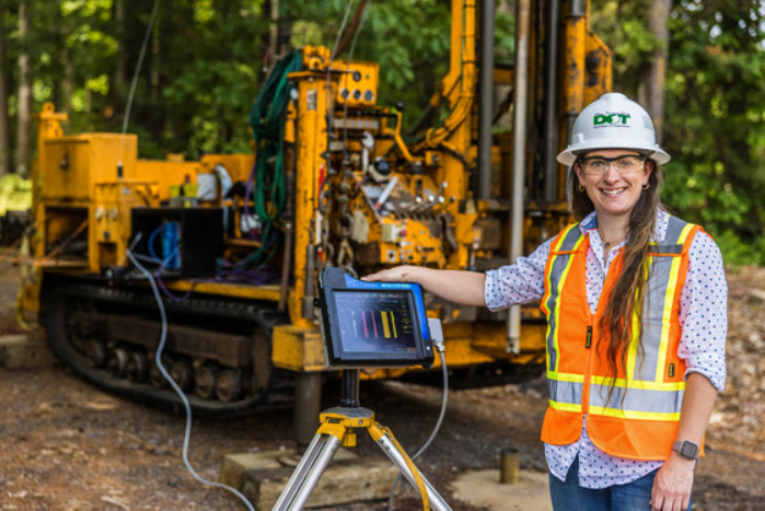
The New Hampshire DOT’s Krystle Pelham with the readout from the MWD rig.
Credit: FHWAThe Montana DOT (MDT) is evaluating MWD technology as part of a 1-year, FHWA-funded pilot program. MDT staff instrumented a rig equipped with multiple MWD sensors to collect data that delivers a continuous profile of the subsurface material. During an A-GaME webinar, Nick Jaynes, MDT geotechnical engineer, described the installation of MWD equipment on the department’s drill rig and the use of MWD to collect data on several projects.
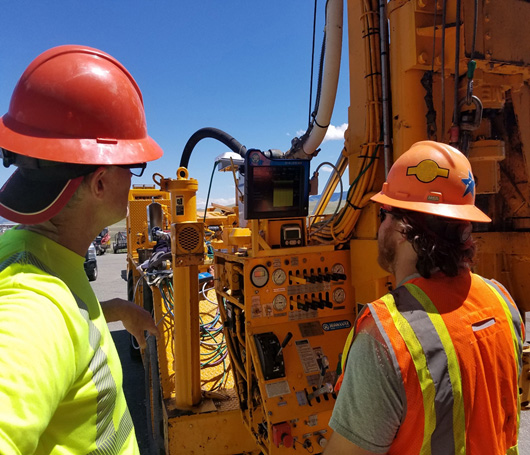
The Montana DOT instrumented a rig equipped with multiple MWD sensors to collect data that delivers a continuous profile of the subsurface material.
Credit: Montana Department of TransportationAlaska Deploys UAS for Project Design, Construction, and Monitoring
The Alaska Department of Transportation and Public Facilities (DOT&PF) has deployed unmanned aerial systems (UAS) across the State to aid in design, construction, and monitoring of large-scale projects. By augmenting traditional survey acquisitions, DOT&PF is able to fill in the gaps with UAS data. Alaska DOT&PF has used fixed wing and multirotor systems to collect light detection and ranging (LiDAR) data, imagery, and environmental documentation since 2019. One of the DOT&PF’s first projects to use data supplemented by UAS is its Sterling Highway Milepost 45–60 Project. The agency’s ability to quickly acquire imagery and LiDAR data and distribute it to the project team not only saves time, it also helps the agency keep the public updated on the project’s development through an online web portal.
PennDOT Tracks Roundabouts’ Safety Benefits
The Pennsylvania Department of Transportation (PennDOT) recently reviewed data for 26 roundabouts on State routes and found that fatalities, injuries, and crashes decreased overall in the time since they were built. An agency news release noted that the roundabouts are at intersections that were previously stop or signal controlled. PennDOT said these roundabouts were selected based on having at least 3 years of crash data available before and after the roundabouts were built. PennDOT data based on police-submitted crash reports from 2000 through 2020 shows that fatalities at these locations were reduced by 100 percent and the total number of crashes decreased by 22 percent.
North Carolina Improves Traveler Information Accuracy
The North Carolina Department of Transportation (NCDOT) has embraced crowdsourcing as a way to exchange real-time traveler information with road users in times of natural disaster. During Hurricanes Michael and Florence in 2018, North Carolina roads experienced unusual flooding and road closures. Realizing that mapping and navigation providers were not publishing accurate road closure information, NCDOT set out to improve the way it engages navigation providers with timely and accurate information. The agency identified key points of contact with each provider in order to maintain relationships that can be leveraged during emergencies. Because of these efforts, stakeholders now enjoy the benefits of better mapping information for closures, traffic incidents, new roadways, and truck routing.
Texas Uses Virtual Platform to Train New TIM Trainers
In Texas, where Traffic Incident Management (TIM) training is mandated for all law enforcement and firefighter professionals, there was a shortage of certified TIM trainers. The Texas Department of Transportation (TXDOT) bridged the trainer gap by using conferencing software to conduct three virtual Train-the-Trainer courses earlier this year. Virtual delivery required overcoming technology challenges, such as poor internet speeds, desktops without a microphone, or access to a shared laptop. Organizers addressed this by sharing the materials in advance, having a dedicated staff member monitor chat messaging, adjusting the instruction to include mini-breaks, including safety service patrol videos to complement the course, and using smaller breakout sessions for traditional tabletop exercises. In all, TXDOT’s three virtual Train-the-Trainer classes led to 77 certified TIM trainers in Texas, and many are already delivering training. Read more in FHWA’s TIM newsletter.
Hear examples of how Virginia DOT has implemented virtual public involvement in this video from FHWA’s VPI Conversations series.
Credit: FHWAVirginia Institutionalizes VPI
The Virginia Department of Transportation (VDOT) began building capacity for virtual public involvement (VPI) in 2019 by hosting an FHWA peer exchange for its staff and partner agencies in the region. Since then, VDOT has rapidly expanded its use of VPI in response to the COVID-19 pandemic. An important part of the agency’s efforts has been working with the FHWA Virginia Division Office to develop guidance on the use of virtual public meetings to augment its public involvement for environmental review projects that require in-person hearings. VDOT staff discussed specific examples of how they have used VPI to support planning, project development, and environmental review in FHWA’s VPI Conversations video series.
Recommended Citation: U.S. Department of Transportation, Federal Highway Administration - Washington, DC (2021) Innovator Newsletter, November/December 2021, Volume 15 (87). https://doi.org/10.21949/1521365