
The Transportation Planning Analysis Unit (TPAU) within ODOT is responsible for providing technical services necessary to support long-range transportation planning and project development. The Unit provides analytical and technical expertise in many areas, including development and application of a statewide model, urban travel demand models, a transportation GHG model, mesoscopic models, and traffic simulation models. Common modeling and analysis tools used by ODOT to conduct and support transportation, air quality, land-use, and economic planning activities are presented in this section.
Oregon has a comprehensive statewide modeling and analysis program-the Oregon Modeling Improvement Program (OMIP). ODOT started this program in 1994 as a multi-agency collaborative effort. OMIP provides a number of services, including addressing federal and state mandates, identifying innovative methods, and expanding ODOT's modeling tools to support effective decision-making. OMIP encourages collaboration and knowledge transfers within the agency to optimize limited monetary and staff resources. OMIP has a number of outreach programs, including peer review of modeling tools, an international peer review panel for the statewide model, partnerships with universities for research and internships, and facilitation of the Oregon Modeling Steering Committee to serve as an active forum for discussion, partnerships, and knowledge transfers between 18 different agencies.
OMIP includes two central elements:
The Committee members include representatives from federal, state, and local agencies and jurisdictions.
The Oregon Statewide Integrated Model (SWIM) integrates the dynamic interaction between Oregon's economy, land-use, and transportation systems into one unified modeling tool. To address the complexity and challenges associated with the dynamic interaction, the SWIM is made up of eight integrated sub-models:
The model facilitates analysis of complex economic, land-use, and transportation interactions. This tool supports decision-makers when considering policy and transportation alternatives. Examples of analyses that use this modeling tool include:
Planning requirements in Oregon were creating a large demand for model development and application services. Four of the nine MPOs in Oregon staff their own modeling services, while the remaining MPOs rely on ODOT for development and application services. In order to shorten model development time and support efficient provision of modeling services, ODOT developed two travel demand model frameworks: one framework for MPOs and a second framework for small cities. Each of these model frameworks was estimated using Oregon-wide data. For each framework, there was a single model estimation effort, which was then deployed in each model area. For each model, the components are calibrated and validated. This approach significantly reduced the model development time. Both models are implemented through a series of script files written in the R statistical programming language, with the exception of traffic assignment, which is carried out using proprietary traffic assignment software.
The modeling needs for a Metropolitan Planning Organization (MPO) are directly related to its responsibilities for meeting specific urban transportation planning requirements established by federal law. These are defined by the FHWA and the FTA and are described in Title 23 (Highways) and Title 49 (Transportation) of the Code of Federal Regulations (CFR). Among these requirements is the development of a 20-year transportation plan that includes both long- and short-range strategies/actions that lead to the development of an integrated intermodal transportation system. Specific factors that must be explicitly considered, analyzed, and reflected, as appropriate, include:
Additional modeling needs are related to the TPR requirement for the preparation of local transportation system plans (TSPs) that "establish a system of transportation facilities and services adequate to meet identified local transportation needs." While the TPR does not regulate transportation modeling, it does set planning requirements that have direct implications for the type of models needed to develop TSPs, namely that:
MPOs also use models to prepare subarea transportation studies. In these instances, a model is focused for a subarea of a city or county to examine detailed land-use or transportation system alternatives, analysis of the transportation system impacts of large-scale development proposals, and the evaluation of the effects large-scale transportation projects, such as bypasses.
In order to facilitate development and maintenance of many travel demand models within the state, ODOT partnered with Oregon MPOs to develop a model framework to use for all MPOs in the state. This was done by using results from the 1994-96 Oregon Household Activity Surveys and by adopting the Portland Metro model structure. This structure is referred to as the Joint Estimation Model in R (JEMnR). JEMnR is a 4-step, state-of-the-practice MPO model class.
The model consists of the following modules:
The Oregon Small Urban Model (OSUM) framework was developed and estimated by ODOT with assistance from Portland Metro. The 1996 non-MPO household activity survey data used for the model estimation was collected from a sample of 3,200 households in eight rural counties throughout Oregon.
The general structure of the model follows a basic three-step process: 1) trip generation; 2) trip distribution; and 3) traffic assignment. Prior to trip generation, there is a pre-generation step that produces all necessary inputs for trip generation using a set of household submodels stratifying households by number of workers, household size, and number of workers by household size. The trip generation model produces person-trip productions, by trip purpose, for each hour of the day. Within the trip distribution step, a destination choice model is used to distribute internal-internal trips, while internal-external, external-internal, and external-external trips are handled with separate procedures. Prior to trip distribution, a submodel is used to estimate the percentages of external-external traffic at each external station and a daily through-trip matrix. Trip assignment is performed using a single-class (auto), equilibrium capacity restraint technique. Currently, ODOT is responsible for more than 10 active OSUM models.
Land-Use Scenario DevelopeR (LUSDR). Land-use models are generally recognized as useful tools for forecasting land-use inputs to transportation models and for analyzing land-use effects of transportation projects. Unfortunately, the complexity of most land-use models gets in the way of their widespread use by planning agencies. The Land Use Scenario DevelopeR (LUSDR) was created by ODOT to fulfill the need to evaluate transportation conditions under uncertain land-use futures. LUSDR includes the land-use behavior and policy sensitivity desired in a land-use model and has a simple structure and manageable data requirements. LUSDR operates at the level of individual households and employment establishments, micro-simulating location decisions of land developments. The model produces a synthetic population of households and applies the following attributes: size, workers, age of household head, income, dwelling tenure, and dwelling type. Households are spatially located within residential developments. Employment is calculated from workers and allocated to economic sectors, employment establishments, and business developments (e.g., shopping centers, office parks, etc.). Residential and business developments are allocated to zones using an iterative process that identifies candidate zones based on land availability and plan compatibility, choosing zones via a location model and reconciling land supply and demand in each zone through a bidding process.
UrbanSim. In 1998, the urban phase of TLUMIP included development of an Oregon Prototype Metropolitan Land-Use Model, UrbanSim. This is an open-source software system designed for integrated planning and analysis of urban development. UrbanSim was designed by Paul Waddell (University of California, Berkeley) and developed with numerous collaborators to support metropolitan land-use, transportation, and environmental planning. It has been distributed on the Internet since inception, with regular revisions and updates.
GreenSTEP. The GreenSTEP model was developed by ODOT to estimate and forecast the effects of policies and other influences (e.g., gas prices) on the amount of vehicle travel, the types of vehicles and fuels used, energy consumption for vehicle travel, and the resulting GHG emissions. The name, GreenSTEP, is an acronym for "Greenhouse Gas Strategic Transportation Energy Planning." The full name of the model helps to describe the model's origin and function.
The origins of GreenSTEP's development and its main applications have been to estimate and forecast GHG emissions from the transportation sector. GreenSTEP was designed to support strategic planning efforts that require the consideration of many possible scenarios and contingencies. It combines higher-level analysis with an ability to compute the effects of multiple factors that influence vehicle ownership and use, energy consumption, and GHG emissions. It runs rapidly, quickly analyzing many scenarios and contingencies.
The initial focus of GreenSTEP was on household travel using light-duty vehicles. This focus reflected a statutory emphasis on reducing emissions from this portion of the transportation sector. GreenSTEP's capabilities are now being expanded to address household travel more completely and to address more portions of the transportation sector. For example, although walking does not produce any GHG emissions, a walk model was added because the amount of walking is an important indicator of the health effects of a transportation and land-use scenario. Work is also underway to incorporate air travel into the household emissions estimates.
In addition to computing GHG emissions, the GreenSTEP model calculates the amount of fuel and electricity consumed for the transportation modes that it models. This enables GreenSTEP to be used to assess potential consequences for fuel consumption, electricity consumption, household fuel expenditures, gas tax receipts, and related effects.
GreenSTEP is a planning model that can be applied at the statewide level or metropolitan level. It is being used to provide analytical support for a number of planning purposes, including: the development of Oregon's Statewide Transportation Strategy for reducing GHG emissions; the Climate Smart Communities Scenarios project for the Portland metropolitan area; the Oregon Governor's Ten-Year Energy Action Plan; and the assessment of the future effects of hybrid, plug-in hybrid, and electric vehicles on fuel-tax receipts.
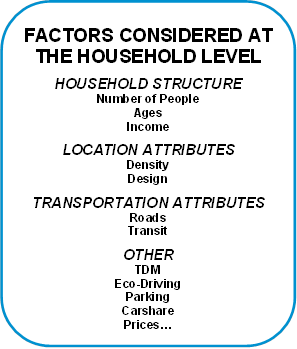
GreenSTEP can be applied at different geographic scales. When the model is applied at the statewide scale, the geographic area is subdivided into counties and population is apportioned to the urbanized, other urban, and rural portions of each county. Similarly, when the model is applied at a metropolitan scale, the geographic area is subdivided into districts and population is apportioned to the urbanized, other urban, and rural portions of the district. However, metropolitan applications may be limited only to the urbanized portions of the metropolitan area. GreenSTEP can be scaled to different geographies because the model performs calculations at the household level. Individual households are simulated based on characteristics.
GreenSTEP then simulates vehicle ownership and use, energy consumption, and GHG emissions for each household given the household's characteristics and other relevant factors, such as fuel prices, land use, transportation services, and the penetration of advanced vehicles in the market.
The household-level model results, and other GreenSTEP calculations, can be used to calculate a wide variety of travel, energy, GHG, economic, and health measures. Examples can be seen in the Statewide Transportation Strategy technical appendices. The large number of model outputs and capabilities for evaluating many scenarios can pose a challenge for making sense of massive amounts of data; data visualization methods (e.g., GreenSTEP Scenario Viewer) are being developed for this purpose.
The GreenSTEP model was reviewed extensively by state, national, and international travel and emissions modeling experts in multiple venues. Evaluation at the national level led to the FHWA adopting GreenSTEP as the basis for their Energy & Emissions Reduction Policy Analysis Tool (EERPAT). In 2010, the American Association of State Highway and Transportation Officials (AASHTO) awarded ODOT staff its President's Transportation Award for Planning for the development of the GreenSTEP model.
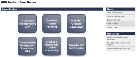
Greenhouse Gas Emissions Reduction Toolkit. This toolkit was developed by ODOT. It is designed to help local jurisdictions identify and explore the kinds of actions and programs they can undertake to reduce vehicle emissions. It can also help local jurisdictions meet other community goals, including helping to spur economic development, increase biking and walking, support downtowns, create healthy livable communities, and more. Each Strategy Report describes an action, program, or policy that can be implemented by a jurisdiction. The report gives an overview of what it is, how it can benefit a community, how costly it is to implement (how long it takes to see results), and gives examples of where it has been used in Oregon. The reports are an entry point to a topic, and are a tool for planners to explore and communicate with respect to the strategies described. Case studies are included that explore the interaction between strategies, and highlight implementation considerations. Figure 4‑1 demonstrates the toolkit starting point by category, and Figure 4‑2 by case study. The toolkit is accessible online via ODOT's website. This is an easy-to-use method of exploring different options quickly.
Figure 4‑1: GHG Toolkit Category Menu
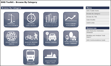
Figure 4‑2: GHG Toolkit Case Studies Menu
The Analysis Procedure Manual (APM) is unique to Oregon. The APM is a comprehensive source on current methodologies and procedures that may be applied to analyze long-term ODOT projects. The APM does not recommend any specific software; rather, it presents best practices for consistent and accurate results. Although the manual addresses multiple topics, the information included in the document is not exhaustive. Topics in the APM include safety, developing existing-year volumes, future-year forecasting, system-planning analysis, mesoscopic analysis, performance measures, analyzing alternatives, segment analysis, un-signalized-intersection analysis, signalized-intersection analysis, multimodal analysis, traffic-simulation models, environmental-traffic data, travel demand modeling, and operational analysis. Use of the manual is supported by the Analysis Procedures Manual User Group (APMUG), which is open to all interested parties and meets quarterly. The manual is utilized by private consultants and other government agencies across the nation.
ODOT developed two Excel-based safety analysis tools:
In addition to the software discussed above, ODOT is currently exploring data requirements for SafetyAnalyst software and other HSM methods based on the Minimum Inventory of Roadway Elements (MIRE).
Static Traffic Assignment Models
Dynamic Traffic Assignment Models
Signalization Intersection
Un-signalized Intersection

