
As of the 2010 Census, Washington had a total population of 6,724,540 in approximately 2,620,076 households, providing an average household size of 2.51 for the state. The Bureau of Labor Statistics reports statewide employment at 3,160,000 at the time of the Census.
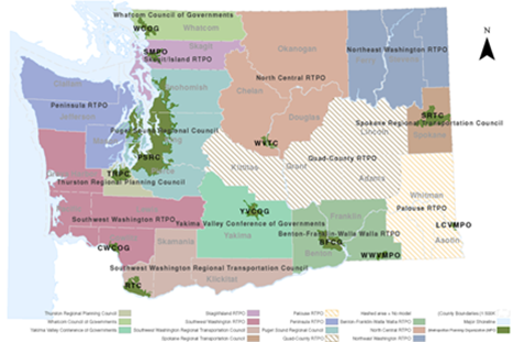
Washington state's economic output and employment is centered in five major industries: manufacturing (28% of total state economy), wholesale (11% of total statewide economy), construction (5% of total state economy), agriculture (2% of total state economy), and transportation (2% of total state economy). Some of the major industry subsectors include: aerospace manufacturing, fuel refinement, agriculture (apples, milk, wheat, and potatoes), and forestry.[1] Figure 1 provides a map of the planning regions within Washington State.
The Washington Growth Management Act (GMA) (Chapter 36.70A RCW) enacted in 1990, requires that Regional Transportation Planning Organizations (RTPOs) with responsibilities similar to those of Metropolitan Planning Organizations (MPOs) in the federal planning process and allocation of funding, are responsible for growth management related tasks with regard to comprehensive planning, capital investment, and protection of natural lands.
Additionally, the Least Cost Planning (LCP) requirement was enacted in Washington's Regional Transportation Plan legislation (RCW 47.80.030). This law states that, "each regional transportation planning organization shall develop in cooperation with the department of transportation, providers of public transportation and high capacity transportation, ports, and local governments within the region, adopt, and periodically update a regional transportation plan that is based on a least cost planning methodology that identifies the most cost-effective facilities, services, and programs."[2]
Figure 1: Map of Washington Planning Regions
WSDOT is charged with constructing, maintaining, and operating the highway, ferry, and other transportation systems throughout the state. WSDOT partners with local agencies to service local roads, rail, airports, and other transportation alternatives. The following bullets summarize the breadth of WSDOT's responsibilities:
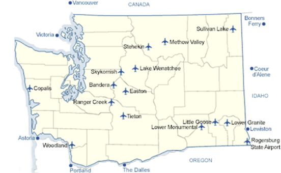
Washington State has a very diverse array of transportation modes and infrastructure. There are seventeen state-managed airports as illustrated in Figure 2. These airports are not only critical to passenger transportation, but also in the movement of critical goods and resources.
Figure 2: Washington State-Managed Airports[4]
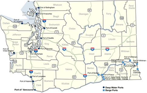
In addition to these valuable air outlets for passenger and commodity transport, Washington state is also home to 11 deep water ports and nine large barge ports. These ports are mapped in Figure 3.
Figure 3: Washington State Ports[5]
Washington State is home to 25 transit systems and the WSDOT Intercity Bus Program, which are integral components of the transportation system. These transit service providers are specified by name and location in the list below.[6]
WSDOT's Rail Division manages the Amtrak Cascades intercity passenger rail service, which runs along the Pacific Northwest Rail Corridor. The 467-mile corridor is one of 11 federally-designated rail corridors in the country. In addition, WSDOT currently supports the Cascades High-Speed Rail Program, which is comprised on several projects to enhance existing services between Seattle and Portland.[7]
WSDOT's six policy goals include: safety, preservation, mobility, environment, stewardship, and economic vitality. The DOT collaborates with regional agencies, local jurisdictions, and private contractors to support these goals by organizing and executing projects, as well as managing and allocating resources.
Washington's Governor, Mr. Jay Inslee, issued an executive order on April 29, 2014, outlining the importance of a statewide model given key policy challenges facing the state. The peer review documented in this report is one of the early steps WSDOT staff members have taken in response to the governor's initiative. The peer review session began with the introductions by Stacy Trussler of the WSDOT Urban Planning Office (UPO) and welcome remarks and policy context by Washington State Secretary of Transportation, Ms. Lynn Peterson. Mr. Shuming Yan, deputy director of the WSDOT UPO presented concept-level purposes to which WSDOT would likely put a statewide model and background information of the State. This section of the report summarizes the WSDOT conceptual thinking about such uses.
WSDOT faces large-scale policy challenges similar to those faced by Departments of Transportation and other transportation agencies across the US. It is concerned with climate change mitigation and adaptation, rapidly-growing goods movement needs, large forecasted growth in both population and the state economy, and an increasingly-constrained funding environment that makes investment scenario evaluation analysis an even more important exercise than in the past. In addition, Washington faces some unique aspects of transportation and land use planning not common among its peer states: the fact that the state has an explicit Growth Management law with attendant regulations and the legal requirement that transportation planning within the state be conducted consistently with LCP principles.
Finally, the Secretary remarked several emerging challenges for transport modeling of which the panelists and WSDOT staff should be aware. The Secretary observed that recent research has illustrated that the market for travel is more nuanced than many state-of-the-practice modeling and supporting data-gathering techniques realize. Ms. Peterson cited examples such as the numerous different motivations for commercial vehicle travel within and outside of cities and the emerging awareness of the way traveler gender - among other individual traveler characteristics - differentiates travel behavior.
Ultimately, for the purposes of the panel discussion WSDOT explicitly identified these likely applications for a Washington statewide model:
After the WSDOT introductory remarks about the state, the agency, and conceptual goals for a statewide model, modeling staff from the three largest MPOs in Washington provided brief overviews of their regions and their regional travel demand forecast models. Since the topic of how a state model would best interact with regional models is of key interest to WSDOT, the MPO model overviews are summarized in Table 1. The question of how state models can and should interact with regional models is addressed later in the "Panel Discussion Details" and "Panel Recommendations" sections.
[1] WSDOT. Washington State Freight Mobility Plan. 2014. Available at: http://www.wsdot.wa.gov/NR/rdonlyres/FD4FC83A-098F-4E0D-A570-0727D8B26888/0/WashingtonStateFreightMobilityPlanPublicComment6102014.pdf
[2] Washington State Legislature: RCW 47.80.030 Regional transportation plan - Contents, review, use. Available at: http://app.leg.wa.gov/rcw/default.aspx?cite=47.80.030
[3] http://www.wsdot.wa.gov/about/
[4] http://www.wsdot.wa.gov/aviation/Airports/
[5] http://www.wsdot.wa.gov/Freight/MarinePortsMap.htm

