
At the beginning of the Peer Review session, each panelist provided a brief ten-minute presentation of their statewide or large-scale modeling experience at the request of WSDOT. The presentations provided a diverse array of modeling areas, ranging in size from California to Maryland. This section will provide more detail regarding application capabilities and general characteristics of the models presented. Below is a list of these models and their respective agencies.
ADOT developed the AZTDM to evaluate the "what if" of current and future scenarios to assist stakeholders in addressing mobility, accessibility, and economic development needs. The model has been used in corridor studies, including the Arizona Passenger Rail Corridor Study (Phoenix to Tucson), the I-11 and Intermountain West Corridor Study, the North-South Freeway and Revenue Analysis, and Arizona's Key Commerce Corridors Study. The model has also been applied in various design concept studies, planning-to-programming project prioritization, forecasts of state highway system volumes, and regional transportation plan development from agencies such as the Central Yavapai Metropolitan Planning Organization, Central Arizona Governments, and three new MPOs (Sun Corridor, Lake Havasu City, and Sierra Vista).
The California Statewide Travel Demand Model is used for long range planning, air quality analysis, and freight movement analysis. One of the primary drivers of the air quality modeling capabilities was the California Energy Commission's (CEC) desire for future fuel projections and fleet projections.
The Oregon Statewide Integrated Model is used to: analyze transportation, land use and the economy in a dynamic, integrated manner. It is used to inform policy and funding decisions and identify potential unintended consequences of changes in infrastructure, services, or regional characteristics. Specific model applications include: the Willamette Valley Forum (2001), evaluating Eastern Oregon Freeway Alternatives (2001), ODOT Economic and Bridge Options Report (2003), Oregon Transportation Plan Analysis (2006), Oregon Freight Plan Analysis (2010), and Economic Impact Analysis Related to a Major Seismic Event (2013).
The RADIUS Model and Mid-America Freight Coalition (MAFC) Freight Model are multi-state models based on the Quick Response System 2 (QRS 2) platform. The former cover two regionally significant corridors that cross state lines: the I-39 corridor from South Beloit, Illinois, to Madison, Wisconsin, and the I-94 corridor from Northern Illinois to Madison, Wisconsin. RADIUS is used for short-term estimation of freeway work zone traffic volumes considering the possibility of diversion using Dynamic Traffic Assignment (DTA). The MAFC model is intended for shipment-level analysis for establishments in the greater Midwest. The Mid-America Freight Coalition (MAFC) Freight Model is a multi-state model that estimates truck movements across the Midwest.
Maryland's key drivers for the development of their statewide model were development of the Statewide Plan and the Smart Green & Growing Initiative. Development of the Statewide Plan requires use of the model for identification of regionally-significant corridors, which involves estimation of passenger travel, rural region travel, and freight travel metrics. The statewide model is used for other long-range planning and investment studies, corridor studies, scenario planning and freight analysis. The MSTM is also being used for the quantitative assessment of adaptation needs, extreme weather scenarios (emergency planning), travel demand management strategies, and reliability analysis.
WSDOT expressed additional interest in how each statewide model was applied to prioritize projects across different modes. Mr. Killough responded that the AZTDM is designed to forecast intercity rail, but the model is not used to compare transit versus highway studies. Mr. Mahapatra stated that the MSTM can conduct system-level studies of corridors that extend beyond MPO boundaries, as it was designed in this manner to model AMTRAK rail, intercity bus services, MARC commuter rail, and commuter bus services.
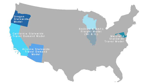
Each model was designed with the above-described applications in mind. This section provides additional detail regarding the development processes and general characteristics of the models presented at the Peer Review. Figure 4 presents a map to geographically represent the models that were discussed by WSDOT staff and the expert panel.
Figure 4: Map of Example Models
Arizona's AZTDM is entering into its fourth generation. The first generation of the statewide model was developed in 2009. This version was a three-step model with a coarse highway network and 1,098 TAZs. The model utilized imported trip generation rates and Quick Response Freight Manual (QFRM) Truck Trip Generation. The second generation of the AZTDM was developed in 2011. This version of the model was enhanced to include 6,090 TAZs and a detailed highway network. The model applied National Household Travel Survey (NHTS)-based trip generation rates and trip distribution. A freight model based on Freight Analysis Framework 3 (FAF3) data, a long-distance trip model, and an improved highway assignment process were each incorporated into the second generation of the AZTDM.
The third and current generation of the AZTDM applies a four-step model, including a transit network and assignment. The model includes person mode choice, a TRANSEARCH-based truck freight model, economic impact analysis, and focused regional models for small MPOs. The fourth generation of the AZTDM is in development stages. This model will include NHTS Add-On information, a population geo-synthesis model, an activity-based travel demand model, a dynamic traffic assignment model, and an integrated land use-transportation model.
Mr. Killough noted that the challenges experienced in the Arizona statewide model development effort included computing environments, funding sources, securing appropriate staff, and assembling data, which included NHTS Add-On Samples only for the two largest MPOs, the limited long-distance travel data, and improved traffic count data. It was also noted that purchased freight data may present issues during model validation.
The California Statewide Travel Model is a tour and commodity-based model that includes 5,450 TAZs and 103 freight model zones. Caltrans conducted a $12 million household travel survey (HHTS) that prompted 48,000 returns. A GPS add-on was used for quality assessment to this survey effort. Additionally, $80,000 was allocated for open source population synthesis development. MPOs are able to use different population synthesis products with the model. Since Caltrans data do not now include truck classification counts, the department is investigating development of a loop detector add-on that will allow traffic counters to sense vehicle type and produce classification counts. Caltrans is also commissioning a future California version of the Vehicle Inventory and Use Study (VIUS), which has been discontinued by US Census Bureau. Caltrans noted that their main model development challenges resided in data acquisition and development.
WSDOT asked whether the California Statewide Travel Demand Model includes ferry movements. Caltrans responded that the model does not include ferries, although they are considered as part of the abstract transit treatment.
The MSTM is a multi-layer travel demand model that operates at national, statewide, and regional levels to forecast and analyze key measures of transportation system performance. The model was developed to assess travel demand in non-MPO regions; conduct regional what-if scenarios due to land use, network changes based on new projects and facilities, and policy changes both in and around Maryland; intercity transit (commuter rail, intercity bus); assist MPO modeling efforts with "external" inputs; and provide a tool that connects all the available MPO models. Performance measures estimated by the model include the following:
MD SHA plans to include dynamic traffic assignment features to model over-saturated conditions, reliability metrics and economic indicators in future model updates.
When developing the MSTM, MD SHA experienced challenges obtaining data from the rural regions and bordering state counties through travel (person and freight), as well as maintaining consistency in data and network assumptions throughout the modeled area. Maryland found that keeping the business case for statewide model development process focused and complimentary and institutionalizing the program for decision-making and staff support also presented challenges to the modeling staff. As Maryland's state-level transportation questions become much more focused on operations, accessibility, reliability, economy, and quality of life, MD SHA had to create a model to meet these demand and sustain its applicability for the planning applications amidst the shifting political environment.
Oregon's model development effort has been ongoing since 1994. Development of the model has been a multi-agency effort led by the Oregon Modeling Steering Committee and implemented through the Oregon Modeling Improvement Program. The Program follows a five-step approach:
Getting the statewide model into application as soon as possible was necessary for a successful and effective program. Challenges were not only technical, there were also challenges integrating use of the model into the long range planning process. It was important to demonstrate the value of the analytical tool to the state and local planners. Oregon also noted that it was difficult to locate specific data and expensive to collect the data that the agency did not already obtain. ODOT approached model development from a long term programmatic view, relying on expertise from an international peer panel from model design to model development. Both contributions from internal staff, consultants and the peer panel were required to pool together the resources and knowledge necessary for successful model development and application.
The RADIUS and MAFC Freight Model operates using a Quick Response System II (QRS II) and General Network Editor platform. These are two separate models. The RADIUS covers about ½ the population of Wisconsin in both urban and rural areas. The model applies user equilibrium assignment but includes a choice step to split trips between freeway and possible alternative routes. In this choice step, some drivers never divert, some drives always divert, and some drivers choose whether or not to divert, but there is a bias to the original route. The majority of the model parameters were derived from studies of work zones in Portage, Tomah, and Milwaukee.
The following steps outline the RADIUS development process:
The MAFC Freight Model is a microscopic truck demand estimator and assignment model that covers 10 Midwest states. Recent and planned updates to the model include an upgrade from a descriptive model to a planning model and an increase in the number of commodities from five to 27 specific commodities specified by Standard Classification of Transported Goods (SCTG) three-digit codes. The upgrade will also incorporate a multinomial logit tour-choice model, randomized, fixed-shares of empties, randomized commodity "enhancers" to scale up the results to match all trucks, and assignment sensitivity to time, distance, tolls, and hours of service rules, including rest periods.
Recognizing that each agency is unique in the resources and costs associated with the model development process, the panelists offered sketch estimates of the expenses associated with their statewide or large-scale model's development.
During the peer review, the panelists and audience members described many lessons they learned in the course of developing models for other states or for similar geographic scales. These observations can be thought of as strategic issues WSDOT (and others) should be aware of in the course of defining a scope for statewide model development. This section of the report summarizes the lessons learned pertinent to planning for, implementing, and sustaining statewide models or models of similar scale regardless of when the pertinent discussion occurred during the peer review session. The final section of this report uses these lessons plus the detailed discussion documented in the following section as the basis for explicit recommendations to WSDOT on how it should proceed with developing a Washington statewide model.
The panel was in general agreement about the following lessons:
WSDOT questioned if any of the agencies experienced conflicts with MPO model forecasts. Maryland has not yet experienced any conflicts with MPO forecasts as a result of the model's focus on an aggregated zone structure, careful calibration of the state model, and avoidance of producing air quality estimates or directly comparable forecasts. Arizona explicitly avoids producing competing forecasts and calibrates total VMT and RMS within MPO portions of state model. A panelist suggested that MPOs should include work items in their Unified Planning Work Programs (UPWPs) to coordinate their modeling efforts with those of the statewide model.

