U.S. Department of Transportation
Federal Highway Administration
1200 New Jersey Avenue, SE
Washington, DC 20590
202-366-4000
Focus
| Accelerating Infrastructure Innovations |
Publication Number: FHWA-HRT-13-008
Date: November 2012
Printable Version (.pdf, 0.3 mb)
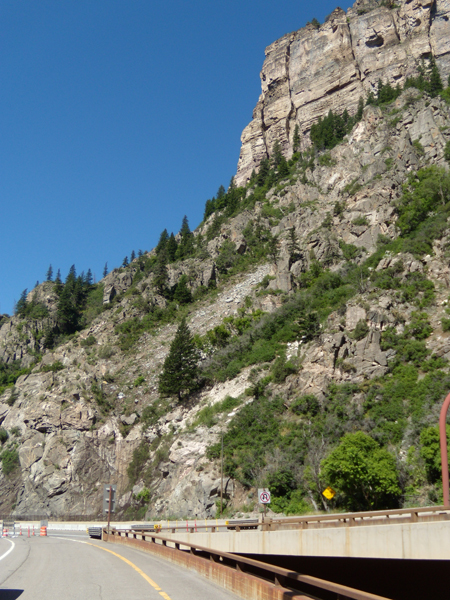
The highly weathered limestone escarpment above the Glenwood Canyon Viaduct in Colorado produces rockfall over an area too large to be assessed by conventional 2D methods. FHWA's new CRSP-3D software offers a more effective solution for evaluating rockfall hazards.
Evaluate rockfall hazards surrounding roadways more effectively with the new 3D version of the Federal Highway Administration's (FHWA) Colorado Rockfall Simulation Program (CRSP-3D).
As development and traffic have increased in mountainous areas, the need to protect people, roadways, and building structures from falling rocks has become more important. Created in the mid 1980s for the Colorado Department of Transportation, the original CRSP program was a 2D model used to predict the behavior of rockfall; determine the need for rockfall mitigation measures such as constructing ditches, berms, fences, and walls; and aid in the design of these measures.
Modeling has helped engineers estimate how rockfall parameters such as bounce height, velocity, kinetic energy, and rollout distance change along the slope length. However, 2D modeling may not be as effective when simulating the rotation and slope interaction of nonspherical rocks, as different rock shapes have different modes of rotation depending on velocity. This may result in inaccurate estimates of rockfall properties, particularly rock rollout, dispersion along and below the slope, and bounce height.
CRSP-3D uses the Discrete Element Method, a numerical modeling approach that incorporates the equations of motion to more accurately model movement of rockfall on a slope surface, including impact, rolling, launching, and sliding. Different possible rockfall paths on a section of slope can be modeled, as well as the rotational movement of nonspherical rocks. Users can build rocks of several shapes, including spherical, cylindrical, and prismatic. The slope profile can be displayed in either 2D or 3D.
"The CRSP software is recognized by users around the world," said Matt DeMarco of FHWA's Federal Lands Highway Division. "While the previous version used a semi-empirical approach, this new 3D version uses an improved numerical modeling method."
Among other updates, the program's definition of surface roughness has changed so that only one value is needed to model the surface roughness for all rock sizes. CRSP-3D also uses just one input value, the hardness coefficient, to model slope material properties. The hardness coefficient measures the elasticity of the collision between a falling rock and the slope, as well as how much tangential resistance the rock is subjected to when sliding on the slope.
The software is accompanied by the CRSP-3D User's Manual (Pub. No. FHWA-CFL/TD-12-007). The manual walks users through installing and operating the program. Included are three simulations designed to familiarize users with the software. The tutorial example highlights how to create a new project and enter the necessary data. A second example features a 3D simulation of rockfall using LIDAR (Light Detection and Ranging) data. LIDAR is a 3D mapping technology that uses a laser to rapidly scan and produce high-resolution images of areas such as rock slopes and outcrops. Also included in the User's Manual is a 2D simulation of rockfall using manually entered slope geometry data.
To download CRSP-3D at no cost, visit www.cflhd.gov/programs/techDevelopment/geotech/CRSP-3D. The software is compatible with Windows®-based operating systems. For more information on CRSP-3D, contact Roger Surdahl at FHWA's Central Federal Lands Highway Division, 720-963-3768 (email: roger.surdahl@dot.gov). For user support, contact Rick Andrew at Yeh and Associates, 303-781-9590 (email: randrew@yeh-eng.com).
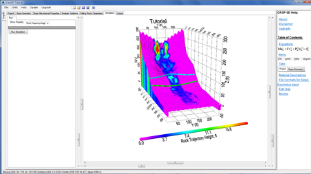
A typical CRSP-3D graphical representation when performing a slope analysis.

