U.S. Department of Transportation
Federal Highway Administration
1200 New Jersey Avenue, SE
Washington, DC 20590
202-366-4000
Federal Highway Administration Research and Technology
Coordinating, Developing, and Delivering Highway Transportation Innovations
 |
| This report is an archived publication and may contain dated technical, contact, and link information |
|
Publication Number:
FHWA-RD-98-139
|
Highway bridges and pavements are usually supported on
whatever ground materials are located directly beneath or within easy access of the
roadway right of way to avoid expensive haul distances. Consequently, highway engineers
need methods for evaluating and upgrading available materials to properly support the
pavement or bridge structure being designed.
During the height of the Interstate construction period, many difficult soil and
site conditions caused highway engineers to search for better ways to eliminate or
ameliorate these situations so that roads and bridges could be built in a safe and
efficient manner. Many areas of the United States had common problems of unstable
soils and poor compaction techniques; but some had regional concerns, such as frost
action in the northern tier of States, and expansive soils in the south. Some areas
even had problems with rock materials that seemed hard during excavation, but later
would deteriorate or exhibit expansive soil behavior after the passage of time while
inside an embankment fill structure.
The solution to these problems was universally recognized by FHWA and SHA's as a
priority research need. Thousands of miles of highways were being constructed annually
in areas where swelling soils, frost susceptible soils, deteriorating shales, hard to
compact soils, and otherwise unstable soils were causing expensive damage to correct.
Even a small reduction in the unit costs to repair these damages would result in annual
savings of several million dollars.
4.1 Background
In the 1970's it was estimated that the annual
cost of damage to highways and streets caused by expansive soils exceeded $1 billion.
In addition, similar estimates were made concerning frost action and thaw weakening
damage in northern states. At the same time, many States were spending millions to
repair, rebuild, or replace highway embankments that were initially constructed as
rock fills and later failed as though they had been built with soft clays. Still
other SHA's were seeking solutions to the high cost of compacting weak soils or
using chemical soil stabilizers to improve strength and/or reduce volume change
tendencies.
The energy crisis was also causing prices of asphalt to skyrocket out of control.
Many places were also concerned about the high utilization factors for quality
granular materials, and efforts were needed to conserve limited sources of these
materials. Research to increase the use of chemical compaction aids that would
reduce the cost of compaction, and research to increase the effectiveness of
existing soil Stabilization systems featuring lime, cement, fly ash, and bitumens
were given very high priority.
4.2 Objectives
The objectives were to develop methods for (1) predicting the performance of and (2) eliminating the engineering deficiencies of soil and rock materials used in earth structures, subgrades, base courses, and as support for highway structures.
4.3 Scope
Research efforts in this project were directed toward developing methods for predicting the volume stability of expansive and frost-susceptible materials and to provide methods for identification, characterization, and evaluation of materials that exhibit unaccountable instability or excessive compressibility when tested and handled by existing techniques. Research was conducted to provide physical and chemical treatment of soil materials to enhance their value and availability for engineering use. Special emphasis was placed on the development of methods for eliminating or relieving pavement distress due to excessive volume changes of expansive subgrades, inadequate strength or durability of subgrade or base components, and frost heave and subsequent weakness in foundation layers.
4.4 Project Description
The major research efforts were in five tasks:
The Soil and Rock Behavior Project was the initial project for FHWA in the geotechnical research arena. The following five sections of this chapter provide a summary of the major contributions of this project.
4.5 Expansive Clays and Shales
The first important decision in the design and
construction sequence for a highway is the route selection. Route selection is
often influenced by social, economic, environmental, and/or political considerations
prevalent at the time of design. Often the geologic materials (and the associated
problems) traversed by the selected route are not considered until the collection
of parameters for the pavement design. For expansive soils, it is important to
recognize the existence of the problem and have a qualitative indication of the
extent of the potential swell problem as early in the design and construction
sequence as possible.
Volume change of expansive soil subgrades resulting from moisture variations
frequently cause severe pavement damage (figure 37). Highways constructed in
the Southwest, Western Mountain, Central Plains, and Southeast geographical
areas are particularly susceptible to these types of damage. A survey of U.S.
highway departments indicated that 36 States have expansive soils within their
geographical jurisdiction. Expansive soils are so areally extensive within parts
of the United States that alteration of the highway routes to avoid the material
is virtually impossible.
FIGURE 37. Pavement damage due to expansive subgrade soils.
Because of the billions of dollars of damage done in the United States to pavements
and buildings each year, many requests for technical guidelines for expansive soils
were generated by SHA's and building owners. Several workshops and technical
conferences were held to discuss the problem and to develop a plan of action and
list of research needs. It was determined at first that the procedures for the
design and construction of pavements on expansive soils did not systematically
consider the variety of factors and conditions that influence volume change, as
evidenced by the continued occurrence of warped and cracked pavements in areas
where expansive soils exist. Thus more accurate methods were needed for identifying,
testing, and treating expansive clays to improve highway design, construction,
and maintenance techniques.
It was also decided that a comprehensive study was needed to achieve the following goals:
(1) the establishment of physiographic areas of similar natural sources and manifestations
of swelling behavior, (2) the development of expedient procedures for identifying expansive
clays, (3) the development of testing procedures for quantitatively (amount and rate of
volume change) describing the behavior of expansive clays, (4) the development and
evaluation of innovative technologies for prevention of detrimental swell under new
and existing pavements, and (5) the development of recommended design criteria,
construction procedures, and specifications for the economical construction of new
pavements, and maintenance or reconstruction of existing pavements on expansive soils.
On the basis of these requests and a series of research recommendations developed by
FHWA personnel, a contract research study was initiated. In the study, the distribution
of potentially expansive soils was defined and their relative expansivity established to
provide a summary of potential problem areas. Various methods for qualitative and
quantitative evaluation of expansivity and pre- and post-construction methods to
minimize the detrimental effects of subgrade volume change were also reviewed under
the study. In addition, field sites were selected, samples taken, and field monitoring
plans developed to evaluate selected methods for predicting expansivity.
The final reports summarize the major research results and present the details of the
research efforts. Volume I presents the text and summary figures relevant to the
discussion of the results of the research tasks. Volume II presents the laboratory
data collected on samples from 22 field sampling sites and the monitoring data from
8 field test sections located in 5 different States (48).
Conclusions drawn from the research results provide better criteria for identifying
and classifying potentially expansive soils; more accurate and reliable procedures
for characterizing and predicting the behavior of expansive soils; guidelines for
application of pre- and post-construction treatment alternatives for minimizing
volume change of expansive soils; and practical design, construction, and maintenance
recommendations for minimizing moisture infiltration into an expansive soil subgrade.
The results of the study that should be implemented are presented in a manual titled
Technical Guidelines for Expansive Soils in Highway Subgrades. Technical
guidelines are presented on the location of potentially expansive soil areas using
occurrence and distribution maps, as well as alternative sources of information; field
exploration and sampling of expansive soils; identification and classification of
potentially expansive soils using index and soil suction properties; testing of
expansive soils and prediction of anticipated volume change; selection of appropriate
treatment alternatives; and presentation of design, construction, and maintenance
recommendations for new and existing highways. Appendixes to the technical guidance
report describe the soil suction test procedure, and include a standard procedure
for odometer swell tests, a bibliography on treatment alternatives, and standards
for field monitoring data.
When the research was completed, FHWA's Technology Transfer program funded an effort
to implement the results. An executive summary report of the research reports was
developed along with various training materials to be used at two training workshops.
The executive summary report (49) was distributed at the workshops along with a
participant's workbook and the technical guidelines manual (50).
4.6 Soil Compaction
Compacted soil is an essential element of highway
construction. Soil density and moisture content is used almost exclusively by the
highway industry to specify, estimate, measure, and control soil compaction. This
practice was adopted many years ago because soil density and moisture content can
be determined very easily via weight and volume measurements.
This doesn't mean that soil density and moisture content are the most desired
engineering properties, because they are not as important to know as the soil
modulus or stiffness characteristics. The latter properties were much more
difficult to measure, so it became standard practice to measure the former
indicators (density and moisture) in order to provide an indirect measurement
of stiffness at a much reduced cost.
In addition to property measurement techniques, engineers and builders both were
seeking some magical chemical to alter the soil properties to make it more readily
compactible. Chemical compaction aids began to surface in large quantities
purporting to be the ideal product to accomplish this highly desired objective,
thus requiring an evaluation protocol to determine which, if any, of these
products were legitimate sources of help with this problem.
4.6.1 FHWA Compaction Aids Research -
A laboratory staff study on the evaluation of two proprietary materials as compaction aids was
completed and a final report published. The testing program used to evaluate the materials
was developed by FHWA and endorsed by the manufacturers prior to its initiation. It was
concluded that neither product produced sufficient alteration of soil properties to be
of any practical utility for acidic soils. Other researchers have concluded from similar,
but broader, studies that these products may only be effective with neutral or alkaline soils.
A more extensive FHWA contract research study on "Chemical Compaction Aids for
Fine-Grained Soils" was completed wherein the feasibility of improving the
compaction characteristics of fine-grained soils by chemical treatment was
determined for a number of chemicals and several proprietary products. The
study was divided into three phases: (1) an office evaluation, (2) laboratory
investigations, and (3) field evaluations of the more promising chemicals.
The results of this study indicate that the effectiveness of chemicals for
improving compactibility cannot be generalized according to classes of chemicals
and soil types because it is a function of many interrelated variables.
The effectiveness of a given chemical must be evaluated with the soil to which it is
to be applied. Laboratory techniques and evaluative procedures that appear suitable
for predicting field performance of chemical compaction aids were developed to
facilitate this "one-on-one" evaluative approach, which was partially
validated by field studies in Iowa and New Mexico. Although several of the 20
chemicals evaluated in the study improved some of the engineering properties of
a few soils, none of the benefits derived were generally or practically significant.
The research results are presented in a two-volume report Chemical Compaction
Aids for Fine-Grained Soils. Volume I of this report includes an extensive
review of appropriate subject literature and the laboratory moisture-density-strength
study of 20 chemicals with 8 soils of varying origin and mineralogy. Also included is
a theoretical discussion of possible mechanisms of chemical compaction aids, properties
of the 26 soils used in the laboratory investigations, and data from supplemental tests
designed to improve understanding of the influences of chemicals on fine-grained soils.
Six chemicals were selected for the more extensive laboratory evaluations with 18
additional soils (51).
Volume II includes moisture-density-strength screening tests performed on several
additional chemicals and an evaluation of the standard AASHTO T-99 moisture-density
test results performed on soil specimens prepared under varying conditions of drying,
pulverization, and re-use. Also presented are the results of a laboratory
moisture-density-strength study of chemicals selected and evaluated through both
qualitative and statistically related procedures, laboratory compaction growth,
and 7-day moist cure results (51). A discussion of the mechanisms of chemical
compaction aids as evaluated through the assistance of infrared spectrography,
vapor pressure osmometer, and zeta potential tests is also included in Volume II.
Based on the total study, an "ideal" compaction aid is described. Volume
II also presents results of field trials conducted on a roadway embankment near
Knoxville, Marion County, Iowa, and a soil-aggregate base near Villanueva, New
Mexico (51).
4.6.2 Soil Stiffness Gauge (SSG) -
As previously mentioned, soil stiffness information is more valuable to designers for
evaluating subgrade support capacity than are density measurements; however, the
difficulty and expense of obtaining quality stiffness data have traditionally
caused engineers to rely on density tests to check quality assurance and control
soil compaction. In the early 1990's, construction engineers began to search for
something that was safer and more economical to use because accidents and production
delays were increasing at an alarming rate. Current methods for testing soil compaction
in the field are slow, labor intensive, unsafe, and of uncertain accuracy.
Because of the labor and time involved, construction sites are often under-sampled,
causing some problems to go undetected, or providing data too late for cost-effective
correction of problems. Sometimes the opposite is true, because some contractors
frequently over-compact in order to ensure passage of acceptance tests and thereby
avoid rework at a later date. Also, engineers tend to over-specify compaction
requirements in order to allow for the significant variability in a noncontinuously
monitored compaction process. Excessive over-compaction can have significant impact
on site preparation costs.
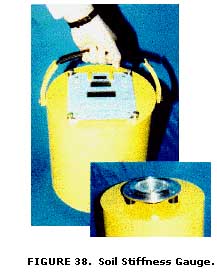 The SSG (figure 38) measures the in-place stiffness
of compacted soil at the rate of about one test per minute. The SSG weighs about
11.4 kg (25 lb), is 28 cm ( 11 in) in diameter, 25.4 cm ( 10 in) tall, and rests
on the soil surface via a ring-shaped foot. The stiffness is the ratio of the
force to displacement: K=P/d. The SSG produces soil stress and strain levels
common for pavement, bedding, and foundation applications.
The SSG (figure 38) measures the in-place stiffness
of compacted soil at the rate of about one test per minute. The SSG weighs about
11.4 kg (25 lb), is 28 cm ( 11 in) in diameter, 25.4 cm ( 10 in) tall, and rests
on the soil surface via a ring-shaped foot. The stiffness is the ratio of the
force to displacement: K=P/d. The SSG produces soil stress and strain levels
common for pavement, bedding, and foundation applications.
In addition to time and cost advantages, a portable compaction device that is quick
and easy to use will save lives and reduce exposure to injuries by allowing the
technician to make measurements at the rate of one in-place stiffness test per minute.
Numerous deaths have been reported where technicians were preoccupied with performing
a nuclear density test or other quality assurance method, and did not see or hear a
heavy construction vehicle before it ran over them. In one incident, the U.S. Nuclear
Regulatory Commission inspectors were called in because the gauge containing Cesium and
Americium sources became exposed when the unit was crushed. The technician was killed.
The paperwork and safety precautions are tedious enough under normal operations, but they
are an order of magnitude higher when accidents occur. A non-nuclear method is in great
demand.
In response to this need for a faster, cheaper, safer, and more accurate compaction
device, the FHWA researchers joined with scientists from the U.S. Department of
Defense's Advanced Research Programs Administration (ARPA) to cosponsor a study
to investigate the possible use of military technology to solve this problem.
As part of the defense reinvestment initiatives, and using funds from the
Technology Reinvestment Project, ARPA authorized FHWA researchers to supervise
the redesign of equipment that was built to locate buried land mines for armed
forces personnel. The military device used acoustic/seismic detectors to locate
the buried land mines, and included U.S. Navy sonar acoustics and electromagnetic
shaker technology developed under another contract to DOD.
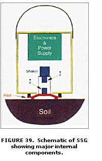 The prototype model was modified to make a soil
stiffness gauge that is portable, lightweight, and safe to use. It rests on
the soil surface via a ring-shaped foot and produces a vibrating force that
is measured by sensors that record the force and displacement time history of
the foot. It is a practical, dynamic equivalent to a plate load test. Figure
39 is a schematic of the SSG showing the major internal components, except for
the D-cell batteries that power it.
The prototype model was modified to make a soil
stiffness gauge that is portable, lightweight, and safe to use. It rests on
the soil surface via a ring-shaped foot and produces a vibrating force that
is measured by sensors that record the force and displacement time history of
the foot. It is a practical, dynamic equivalent to a plate load test. Figure
39 is a schematic of the SSG showing the major internal components, except for
the D-cell batteries that power it.
The device has been "Beta" tested by FHWA and several SHA's. Thousands
of soil stiffness measurements have been successfully made at highway embankment
and pipe backfill sites on sand, clay, and sandy loam soils. When converted to
density values using correlation charts, these measurements are within plus or
minus 5 percent of companion measurements made with a nuclear density gauge.
Production devices are being made for further evaluation at sites representing
a cross-section of U.S. applications and soils. Future models will include onboard
moisture measurement instruments and a global positioning system (GPS).
4.7 Soil Stabilization
The concept of soil improvement or modification
through Stabilization with additives has been around for several thousand years.
At least as early as 5000 years ago, soil was stabilized with lime or pozzolans.
Although this process of improving the engineering properties of soils has been
practiced for centuries, soil Stabilization did not gain significant acceptance
for highway construction in the United States until after World War II. Today,
Stabilization with lime, lime-fly ash, portland cement, and bituminous materials
is very popular in some areas of the country.
One of the major concerns has been the shortage of conventional aggregates. The
highway construction industry consumes about half of the annual production of
aggregates. However, this traditional use of aggregates in pavement construction
has resulted in acute shortages in those areas that normally have adequate supplies.
Other areas of the country have never had good quality aggregates available locally.
Metropolitan areas have also experienced shortages. The reasons include lack of the
raw materials, environmental and zoning regulations that prohibit mining and production
of aggregates, and land-use patterns that make aggregate deposits inaccessible. These
factors, and others, combine to produce an escalation of aggregate cost, with a resultant
increase in highway construction and maintenance costs. Consequently, there was a great
need during the early stages of this research program to find more economical replacements
for conventional aggregates. A natural result is that attention must be focused on
substitute materials such as stabilized soils.
Another area of concern had been the energy crisis brought on by the temporary
shortage of petroleum. It rapidly became a practice to consider the energy demands
of a project as well as cost. In terms of highway construction materials, the trend
was toward the use of materials that required less energy input in their production,
handling, and placement. A study revealed that the energy requirements for producing
the materials for various asphalts, crushed stone, and portland cement concrete pavements
ranged from 30 to 96 percent of the total energy required for production, handling, and
placing of various pavements. Since relatively small quantities of binders such as lime,
cement, fly ash, and asphalt, could be used to improve pavement layers using Stabilization
technology, total energy demands may be reduced as well as costs.
The major objective of the soil Stabilization research project was to develop information
on materials that, when applied to soils of inadequate natural stability, would be capable
of achieving stabilized soil subgrades and surfaces of sufficient strength to satisfy certain
highway construction needs. It was also considered important to establish specific soil
Stabilization requirements to guide the development and evaluation phases of the soil
Stabilization research program. These requirements are expressed in terms of both the
strength and thickness parameters of the stabilized-soil layer that will satisfy anticipated
construction needs, and include consideration of certain limiting initial soil conditions
that might be encountered in highway operations. Desirable maximum limits of curing time
and quantity of stabilizer necessary to achieve the Stabilization objectives were also
needed.
4.7.1 Soil Stabilization Manual -
A two-volume user's manual was developed for FHWA to provide guidance for pavement design,
construction, and materials engineers responsible for soil Stabilization operations associated
with transportation systems. Volume I of the manual Pavement Design and Construction
Considerations describes a method for selection of the type of stabilizers as well as
pavement thickness design methods and construction information. Quality control, guide
specifications, cost, and energy considerations are contained in the appendices (52).
Volume 2 of the manual Mixture Design Considerations was prepared for materials
engineers. This volume describes methods for selection of the type and amount of stabilizers.
Methods of estimating stabilizer contents are presented as well as detailed test methods,
mixture design criteria, and typical mixture criteria (52).
The manual is directed to the engineer who is reasonably familiar with pavement technology,
but who has limited experience with stabilized soil construction. Current technology of soil
Stabilization is presented in a complete but concise format such that the engineer can grasp
the key elements and apply the information to specific needs. Suggested additional references
are provided so that the reader may follow up on details of interest that are beyond the scope
of this manual.
Basically, the manual was developed to provide guidance to design and construction engineers
of highway agencies when using soil Stabilization in lieu of high-quality aggregates for base
and subbase layers in pavement structures. The manual illustrates techniques and advantages
of using soil Stabilization as a means of meeting shortages of local aggregate supplies and
demonstrates the cost effectiveness of such utilization through examples.
Specifically, soil Stabilization as addressed in the manual is limited to the following
stabilizers: lime, lime-fly ash, portland cement, asphalt, and some combinations of these.
The advantages of each stabilizer, mixture design procedures, characterization for
structural design, and construction methods are covered for each Stabilization method.
In addition, a chapter is devoted to structural design utilizing stabilized materials in
several pavement design methods, including AASHTO and elastic layered systems. Examples
of specific situations are provided to illustrate the use of the manual as well as
demonstrate how stabilized layers may be substituted for conventional granular
materials.
4.7.2 Lime Stabilization Research -
The results of an FHWA contract research study on the "Role of Magnesium in the
Stabilization of Soils with Lime" indicated that, for all practical purposes,
dolomitic or calcitic hydrated lime are equally effective for producing strength gain.
However, calcitic lime was recommended for use with all soil types if reducing plasticity
was the purpose of lime treatment.
The final report, The Role of Magnesium Oxide in the Lime Stabilization, is
presented in three volumes (53). This report presents the results of a laboratory
study to evaluate the relative effectiveness of calcitic and dolomitic lime for the
Stabilization of fine-grained U.S. soils. Evaluation of the relative effectiveness
of lime, either obtained from commercial sources or manufactured in the laboratory,
was based on the ability of the lime to reduce soil plasticity and increase its confined
compressive strength.
Thirty-five clay soil samples, representative of major U.S. soil series, were
treated with the various limes and were examined by x-ray diffraction, scanning
electron microscopy, chemical analysis, petrography, and differential thermal tests
to identify the specific soil or lime properties that govern the response of soil to
lime treatment.
4.8 Frost Heave and Thaw Weakening Damage
The ravages of frost action on roads and streets
is well documented by the news media each spring and by county and district maintenance
engineers throughout the Northern States. For example, The Road Information Program
(TRIP) estimates that more than $2 billion is required to rebuild the thousands of
miles of pavement that are destroyed each winter in the United States. This expenditure
is in addition to the cost of filling potholes and surfacing pavements with minor damage.
According to TRIP, automobile repairs resulting from rough pavements and increased cost to
transport goods because of detouring to avoid damaged roads should also be added to this
cost to fully assess the impact of severe winter weather.
The problem of maintaining roadways and airfield pavements in areas of seasonal frost
has long been a major concern to pavement design engineers. Although pavement designers
have attempted to provide protection against the detrimental effects of frost action,
severe winters have demonstrated that a basic and rational methodology for analyzing and
designing pavement systems in cold regions did not exist during the early stages of this
research project.
The seasonal variation in the serviceability of a pavement is very pronounced in areas
subject to alternating freezing and thawing. The combination of freezing and thawing
of pavement subgrades is commonly called frost action. Differential pavement surface
heaving (poor rideability) frequently is the effect of freezing, and subsequent thawing
may lead to a greatly reduced load-carrying capacity due to thaw weakening. Many potholes
and other pavement breakups (distress) result from thaw weakening.
Some soils are more susceptible to frost action than others, and the amount of heave
that occurs is not a good indication of how much strength loss will occur during the
thaw period. It is also probable that a soil of lower frost susceptibility will experience
greater heave than a soil of higher frost susceptibility if placed under more adverse
temperature and water conditions. In fact, a highly frost-susceptible soil will not heave
at all if either one of these two conditions (temperature and water) is missing. Conversely,
clean granular materials not normally classified as frost susceptible will heave if the
temperature and water conditions are sufficiently adverse.
4.8.1 Differential Heaving - Because the amount of heave is dependent on three conditions that can be quite variable-frost susceptibility of the soil, freezing temperatures, and access to groundwater-uniform heaving cannot be expected (figure 40). The differential heaving that results causes surface irregularities and general surface roughness in the form of bumps, waves, and distinctive cracking. Severe cases of differential heave will usually reduce traffic speeds significantly and may cause damage to vehicles or loss of control of the vehicle. The potential for abrupt differential heave at cut-to-fill transitions or culverts requires special design considerations.
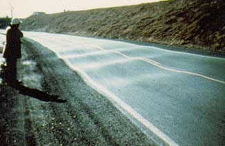
FIGURE 40. Pavement damage due to frost heave.
The amount of heave that occurs is not entirely a result of the expansion of free water in the soil voids when freezing temperatures penetrate the subgrade soil mass. This can often be a small percentage of the total heave. In severe cases of heaving, the extent and rate of growth of ice lenses are determined by the soil's ability to draw water from below by capillarity and also by the rate and depth of penetration of the freezing temperatures. The formation of ice lenses responsible for heaving is governed by the interaction of heat and mass transfer (moisture movement) in porous soil media-a very complicated phenomenon. The growth of ice lenses also results in decreased soil density. After several cycles of freezing and thawing, the soil fabric can be adversely changed depending on the type of soil and the amount of ice lens buildup.
4.8.2 Thaw Weakening - Thaw
weakening is considered by many to be the more critical manifestation of frost action.
It is just as complicated as the heave problem and it is probably more difficult to
evaluate or predict. This problem occurs when the ice lenses formed in the subgrade
during freezing begin to thaw from the surface downward. This thawing results in melt
water being trapped between the pavement and the still frozen portion of the subgrade,
which, accompanied by loading of the soil in its loosened states, generates excess pore
water pressure and a corresponding decrease in load-carrying capacity. The duration and
frequency of load application (static versus dynamic) may also impact load-carrying
capacity; that is, dynamic loading may be more destructive to soil structure, thereby
reducing strength.
The increase in water content resulting from freezing and subsequent thawing is more
detrimental for some soils than for others. The stability of fine-grained soils is
more sensitive to changes in moisture content than is the stability of granular materials;
that is, very slight increases in moisture content for silts and clays significantly
decrease their stability while similar changes in water content do not affect the
performance of granular materials. However, soil moisture content cannot be used as an
indirect measure of thaw weakening because certain clay soils lose significant support
capacity during thawing without significant increase in bulk moisture content.
A different set of physical and environmental factors influence heave and cause
subgrade weakening, thus requiring separate evaluations.
The frost action problem consists of a series of interdependent factors or parameters
that vary over a wide range of values. Understanding the mechanism of frost action in
soils requires a knowledge of soil behavior including soil physics. The frost susceptibility
of soils is still a relatively unknown quantity; however, it is generally recognized that a
soil is susceptible to frost action only if it contains fine particles. Most studies have
shown that soils free of fines (particles smaller than the 200-mesh sieve) do not develop
significant ice lens buildup or ice segregation. As a result, the engineering community
has used various indirect measures or indicators based on particle-size distribution,
pore-size distribution, grain shape, and plasticity characteristics. All of these
contribute to frost susceptibility or ice lens buildup in varying degrees.
4.8.3 Coordinated Research Efforts - Due to
the expense and large extent of evaluating all of the prior FHWA
and SHA research studies on frost action, it was decided to develop
a comprehensive research project that would utilize the combined
resources of FHWA, the Federal Aviation Administration (FAA), and
the Office of the Corps of Engineers (OCE) in the Department of
Defense. A contract was signed with the OCE's Cold Regions Research
and Engineering Laboratory (CRREL) in Hanover, New Hampshire, to
evaluate, validate, and refine certain selected frost action techniques.
The CRREL study included an evaluation of the various devices for
measuring frost susceptibility that were developed earlier by FHWA
and the SHA's, and the development of full-scale field test sites
to provide correlative data. The field data were also used to validate
and refine a mathematical model and laboratory predictive techniques
for assessing strength loss due to thaw weakening. Three test methods
for predicting frost susceptibility were checked against the field
test data for eight soils studied at the field test sites (54).
A computer model of frost leave and thaw weakening was developed
from existing data obtained from earlier studies. It is a finite
element model that couples heat and moisture transport in freezing
soil water systems and provides quantitative predictions of the
frost heave and thaw weakening a soil will experience under different
moisture and temperature conditions (55).
A laboratory soil column device was designed and built by CRREL
to nondestructively measure moisture content, density, and soil
suction changes that occur during unidirectional freezing of the
soil sample. A dual gamma energy source was used to simultaneously
monitor the changes that occur as the soil sample was gradually
frozen and thawed, without having to periodically stop a particular
test to take a moisture and/or density sample. The soil column results
were used to refine the computer model while researchers waited
for the measured results of the field test sites.
Another laboratory segment of the project involved repeated load
triaxial compression tests on undisturbed samples of the test site
soils. The samples were obtained by coring the frozen subgrade soils
during the first winter cycle of the field test program. The samples
remained frozen until tested and, upon completion of the repeated
load tests, the samples were allowed to thaw and then retested in
the same manner. The test loads were stopped before the samples
failed so that they remained suitable for retesting. The next tests
were run on the same samples at different stages of recovery from
thaw weakening.
Thaw recovery was artificially produced by desaturating the thawed
specimen to various partial saturation points. The CRREL researchers
monitored moisture content, density, and stress state variables
including moisture tension. The deformation moduli were expressed
in terms of these variables. Various resilient moduli for the soils
at several depths in each test section were analyzed to determine
which values gave surface vertical displacements that matched the
measured field values.
The CRREL researchers and the sponsors (FHWA, FAA, and OCE) selected
two field test sites to verify the analytical and laboratory predictive
techniques developed under this project: an off-road test site on
highway department land at a district maintenance depot in Winchendon,
Massachusetts, and an FAA site at the Albany County Airport.
To minimize site-associated difficulties, it was decided that a
number of different soils would be studied under the same environmental
conditions by importing selected problem soils to the Winchendon
site and placing them in prepared trenches (cells). The Winchendon
site was chosen because it has a high natural groundwater table,
granular subsurface soil with a relatively high permeability, and
a relatively deep frost penetration. Twelve different soils were
obtained from various parts of Massachusetts and several neighboring
States. Each soil was placed in a cell at two different water table
elevations and capped with a thin bituminous surface course.
The data that was collected in the field tests are as follows:
In addition to the above data, Repeated Plate Bearing (RPB) tests were run
by CRREL and FHWA during each seasonal variation to obtain appropriate pavement
response data (deflections) under certain selected loads.
The Albany County Airport site involved the construction of an extension to
an existing taxiway and an existing, but little-used, taxiway pavement that
had experienced detrimental frost effects. The sampling and testing programs
at the Albany site were very similar to those for the Winchendon site.
These carefully controlled and well-documented laboratory and field test studies
provided a valuable data base that was used to develop new methods to solve
the frost heave and thaw weakening problems. A comprehensive set of design and
construction guidelines for pavements in seasonal frost areas was developed
by the CRREL engineers with financial assistance provided by FHWA's Technology
Transfer program (56).
4.9 Performance of Problem Ground Materials
During the most prolific construction years of the U.S.
Interstate Highway System, many large highway embankment sections were built with shale
materials taken from cut sections or borrow sources and deposited in the embankment prism
as if they were rock materials that did not require thin lifts and compaction processing.
In many situations, the shales were of a type that appeared to be as hard and durable as
rock while contained in their natural environment, but were subject to large-scale
deterioration pressures when exposed to oxygen and other factors while functioning as
a fill material in a large highway construction project.
Some of the clay shales deteriorated so fast that they reverted back to a soft soil that
caused the embankments to fail (figure 41), especially if they were placed on steep slope
angles as most rock fills are constructed. During one period of the 1970's, many of these
landslide-type failures occurred in several States, prompting an outcry for comprehensive
research studies to determine causes and remedies for this problem scenario.
In response to these requests, FHWA researchers studied the work of previous investigators
and developed a comprehensive research plan to study the shale deterioration problem.
Initial findings determined that compacted shale embankment problems can generally be
divided into two categories: (1) those involving settlement and possibly lateral movement
and (2) those involving slope instability. Both problems arise in part from the fact that
embankments are commonly constructed as rock fills with material placed in 0.3-m (3-ft) to
1.2-m (4-ft) lifts and compacted only by hauling and spreading equipment. This practice
can result in large voids within the fill, which tend to collect material when the
deterioration process begins. The introduction of water into the fill accelerates the
deterioration process and causes a reduction in the void spaces, resulting in settlement
within the fill. A reduction in shear strength also results from the deterioration process,
causing slope failures to occur in some extreme cases.
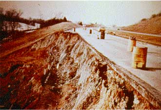
FIGURE 41. Shale embankment failure on I-64 in Indiana.
The obvious remedy for problems associated with shale materials
is to mechanically process the materials during construction so that additional deterioration
occurring during the service life of the embankment will not cause any significant embankment
distress. The ease or difficulty of breaking down the shale material will determine the cost
of the required processing. For example, a shale material that is mechanically hard when it
comes out of the source area and nondurable (considerable slaking with time) is the most
expensive shale material to use in an embankment because it is difficult to process to the
point where subsequent deterioration will not cause excessive, nonuniform settlement and/or
slope failure.
It is the consensus of engineers and researchers that the highway designer finds
degradation and slaking to be the most important shale properties. Degradation is
the reduction in particle size that results from construction processing, and slaking
is the decomposition of the shale materials due to weathering within the new environment
(embankment). In both cases, the amount of deterioration of fresh material (parent shale
from the borrow or cut source) must be predictable to allow a proper design of the
embankment. The degree of slaking that will occur after placement in the embankment will
affect the geometry of the embankment and/or the amount of processing the shale will require
during construction. The ease or difficulty of breaking down the shale material determines
the cost of the required processing.
4.9.1 Shale Embankment Research - Based
on the initial results, FHWA contracted to perform a comprehensive 4-year study to develop design
and construction guidelines for using deteriorating shale in embankment fills. A separate contract
was also issued to conduct several workshops in regions of high shale availability to teach SHA's
and FHWA field personnel how to recognize shale deterioration problems and offer practical solutions.
An executive summary report of the various research reports would be developed and distributed at
the workshops to help field engineers implement the prominent findings of the research project.
A participant's workbook was also to be developed and distributed along with the executive summary
and a copy of the technical guidelines manual to be developed by the researchers.
The results of this study definitely indicate that compacted shale embankments can be
designed and constructed economically to preclude subsidence and shear failures. The
underlying cause of excessive settlement and slope failures in highway shale embankments
appears to be deterioration or softening of certain shales with time after construction.
The main difficulty is determining which shales can be placed as rock fill in thick lifts
(0.6 m to 1 m (2 ft to 3 ft)), and which shales must be placed as soil and compacted in thin
lifts (0.2 m to 0.3 m (8 in to 12 in).
The researchers developed procedures for anticipating the performance of shales in
embankments from simple slaking indexes and delineated procedures for characterizing
the shale materials, determining durability indexes, compaction tests including criteria
for oversize shale gradations, and a simple test on compacted samples to assess expected
compressibility of saturated shales for estimating long-term settlement potential.
The final report provides guidance on geological investigations, durability classification
of shales, design features, and construction procedures unique to compacted shale embankments
for highways. Guidance is also given on techniques for evaluating existing shale embankments
and remedial treatment methods for distressed shale embankments. Index tests and classification
criteria for determining shale durability, techniques for evaluating excavation characteristics,
and alternative procedures for excavation, placement, and compaction of shales to achieve adequate
stability and minimum settlement are described. The use of drainage measures, selective excavation,
and placement of nondurable shales in thin lifts with procedural compaction provisions based
on field test pads is emphasized (57,58).
4.9.2 Rockfall Hazard Mitigation - Public highway agencies are expected to provide a safe and efficient ride for its users. The traveling public not only expects it, they demand it. When serious consequences result from an unsafe situation, litigation is sure to follow. Rockfall is a common highway safety hazard in mountainous terrain (figure 42). The loss of life and property, serious injury, disruption of traffic, and expensive maintenance are major problems in many States. Costly litigation actions against States due to rockfall-caused accidents defer large sums from highway budgets that are needed for roads and bridges.
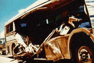
FIGURE 42. Bus badly damaged by large boulder at rockfall site.
Keeping roadways clear of rockfall debris is made more difficult in constricted
transportation corridors where rock cuts are required. In some States
rock slopes are rare but in more mountainous States, many miles
of roadway pass through steep terrain where rock slopes adjacent
to the highway are common. Some of these manmade slopes are very
high. Many are situated near the base of rugged natural slopes that
extend hundreds of meters further upslope.
There is an inherent rockfall potential at these sites. This potential
is compounded by the way our highway systems have evolved over many
years. In the past it was normal construction practice to use overly
aggressive blasting and ripping techniques to construct rock slopes.
Although this facilitated excavation, it frequently resulted in
slopes more prone to rockfall problems. In some cases, uninformed
designers were creating these unsafe rock slopes in order to satisfy
architectural desires for a natural looking rock face. In addition,
cut slopes are subjected to a broad range of climatic conditions
that also affect the overall slope stability. Where these conditions
exist, agencies are faced with the monumental task of reducing rockfall
hazard.
It is estimated that a combined outlay of several hundred million
dollars is spent each year to mitigate rockfall problems in this
country. One recent incident occurred on July 1, 1997, on Interstate
40 in western North Carolina after a heavy rainfall caused a large
rockfall to close all four lanes of the Interstate highway for over
4 months. Two cars were trapped and five people were injured. In
addition, seven people were killed on the detour route in truck-related
accidents that were attributed to the poor level of service provided
by the lower standard highway route used as the detour facility.
The rockfall slide area was approximately 100 m wide and contained
more than 300,000 cubic meters of rock materials that had to be
removed at a cost of more than $3 million.
An additional $1 million was spent to place a protective rock curtain
over the cleared slope and construct a barrier wall at the toe of
the slope to block further rockfall debris. The tourist industry
claimed that it lost $40 to $50 million in business revenue during
the shutdown period. A review of the remaining 32 km (20 miles)
of this particularly dangerous highway section has resulted in an
estimate of $40 million to correct the remaining potential rockfalll
problems on this highway that was constructed in the early 1960's
using construction blasting methods that blew the rock formations
to unnecessarily high proportions.
The extreme danger to the traveling public and the significant economic
impact of falling rocks on the roadway require an accurate assessment
of rockfall probability and extent. In recognition of this problem,
FHWA and several SHA's pooled their resources to initiate a program
to develop a "proactive" system to improve an agency's
ability to identify and respond to adverse rockfall situations.
Prior to this cooperative approach, SHA's relied on a reactive system
of identification and treatment to prioritize rockfall projects
and allocate available repair funds. Experience has shown that a
proactive system is more legally defensible than one that reacts
to accident history and annual maintenance costs at a site to fix
a problem situation.
In addition, it was discovered that a reactive system had several
engineering deficiencies, and may not reflect the true potential
for future rockfall events. The annual maintenance costs in a rockfall
section generally represents the cost to clean out the catch ditch
and to patrol the highway for rock debris on the roadway. However,
if an adequately designed catch ditch performs well (no rock on
the roadway) but needs regular cleaning, the maintenance cost may
be high while the hazard to the motoring public is low. This would
indicate that these two items are not sufficient by themselves to
develop a rockfall priority list. In addition, this technique relies
on information reported by highway maintenance crews, law enforcement
personnel, the general public, emergency response personnel, etc.
Such a diverse group is not adequately trained to systematically
document or evaluate rockfall events.
The first step in developing a proactive system to address the rockfall
problem was to develop a Rockfall Hazard Rating System that could
be used by all agencies confronted with serious rockfall problems.
Using resources from its own research budget and several SHA's including
Arizona, California, Idaho, Massachusetts, New Hampshire, New Mexico,
Ohio, Oregon, Washington and Wyoming, FHWA arranged with the Oregon
DOT (ODOT) to develop a generic Rockfall Hazard Rating System (RHRS).
The RHRS is a tool for managing rockfall sites along highway routes.
The system contains six main features:
These features are discussed in detail in the research report and engineering
manuals developed by ODOT for use in a series of workshops funded by FHWA's
Office of Technology Applications (59, 60,61).
This new process developed by ODOT appropriately places the responsibility for
slope evaluations and design concepts with properly trained and experienced
staff. In Oregon's case, that responsibility rests with its staff of engineering
geologists. Utilizing their expertise and judgment, they have demonstrated that
reasonable and repeatable slope ratings can be achieved. In addition, appropriate
state-of-the-art design concepts were advanced for project development consideration.
Experience with the RHRS has been very favorable. Courts have ruled that it
is unreasonable to expect an agency to have at its disposal all the funds necessary
to deal with all the rockfall safety related issues at once. It is necessary
though, to have some kind of a proactive system in place that provides quality
information to designers for project development and helps management make rational
decisions on how to prioritize projects to best allocate scarce repair funds.
The response by agency management has been one of relief and acceptance. Managers
believe that public safety is now best being served and that greater legal protection
is afforded the agency by having the RHRS in place in their State.
4.10 Publications and Implementation Items
Research and development activities for soil and rock behavior areas were very successful. Numerous quality reports were generated that give valuable guidance on how to treat various problem soil and rock materials, and new ideas and methodologies are documented in each report. Many technology transfer items were developed and disseminated to practicing engineers. Workshops and training courses were also conducted to enhance the implementation process.

