U.S. Department of Transportation
Federal Highway Administration
1200 New Jersey Avenue, SE
Washington, DC 20590
202-366-4000
Federal Highway Administration Research and Technology
Coordinating, Developing, and Delivering Highway Transportation Innovations
 |
| This report is an archived publication and may contain dated technical, contact, and link information |
|
Publication Number: FHWA-RD-03-092 Date: May 2006 |
||||||||||||||||||||||||||||||||||||||||||||||||||||||||||||||||||||||||||||||||||||||||||||||||||||||||||||||||||||||||||||||||||||||||||||||||||||||||||||||||||||||||||||||||||||||||||||||||||||||||||||||||||||||||||||||||||||||||||||||||||||||||||||||||||||||||||||||||||||||||||||||||||||||||||||||||||||||||||||||||||||||||||||||||||||||||||||||||||||||||||||||||||||||||||||||||||||||||||||||||||||||||||||||||||||||||||||||||||||||||||||||||||||||||||||||||
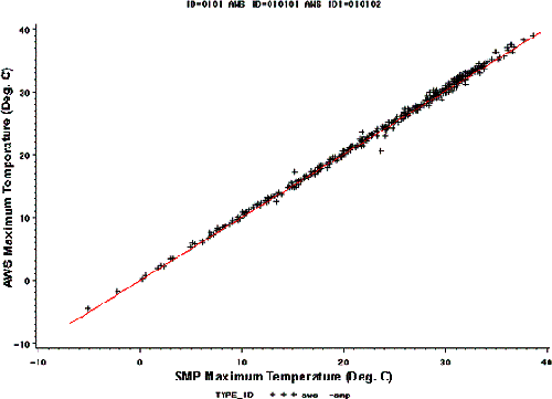
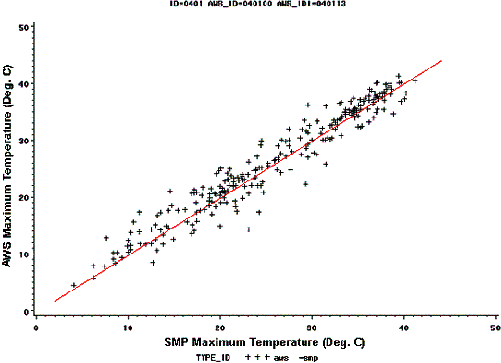
Verification of LTPP Virtual Weather Stations Phase I Report: Accuracy and Reliability of Virtual Weather StationsTask 3: Determine Accuracy of Vws Estimates and Verify The Vws AlgorithmUnder this task, the accuracy of the measured temperature data, year-to-year variation in data, and factors affecting VWS estimates were studied. Also, different methods of estimating weather data were presented and their effects on accuracy were determined. Accuracy of Measured Temperature DataSome LTPP sites are instrumented with both AWS and SMP probes. For some sites, the SMP and AWS measured temperatures agreed very well, while for others, it did not. Figure 10 shows the AWS versus SMP measured maximum daily temperatures for SPS–1 site ID 010100. The two measurements were quite close for this section. Figure 11 shows the same information for SPS–1 site ID 040100 (Arizona). It shows that there is some variation between the two measurements. The difference between the SMP and AWS measurements is used to determine the accuracy of the measured data within a site. Table 23 includes the mean and standard deviation of the difference for the maximum and minimum daily temperatures and precipitation for eight LTPP sites. Six sites had one AWS and one SMP installation, and two sites had one AWS and two SMP installations (these sites are shaded and identified with duplicate AWS IDs). A total of 2661 days of common SMP and AWS data exist in this database. There were 52 to 436 days of data (266 days on average) for each site. The average mean difference per section for the maximum temperature was –0.6 °C (overall mean was –0.7 °C). The average standard deviation per section was 0.8 °C (1 °C overall). The mean difference for the minimum temperature was 0.3 °C, and the standard deviation was 1.1 °C (0.2 and 1.8 °C overall, respectively). The standard deviation of the daily difference for precipitation was 2.1 mm (2.7 mm overall). Table 24 includes the monthly data for the maximum and minimum temperatures, precipitation, and FI. Comparing with the daily difference, the standard deviations of the differences for the monthly minimum and maximum temperatures were less and the mean differences were the same. The mean difference for precipitation was –4.6 mm, and the standard deviation was 18 mm. The mean difference for the FI was 0.3 °C, and the standard deviation was 1.9 °C. This comparison shows that different climatic measurements within the same site are not identical and show some differences. These differences are related to differences in instrumentation and operation. When determining the accuracy of the climatic estimates from nearby weather stations, the instrumentation variation should also be taken into account. The instrument variation was around 1 °C for LTPP sites (0.8 °C for maximum and 1.1 °C for minimum temperatures). This variation is about 40 percent of the variation of the VWS estimates, which are 2.75 and 2.26 °C for maximum and minimum temperatures, respectively, in table 14.
Figure 10. Graph. AWS versus SMP measured maximum temperature for site 010100.
Figure 11. Graph. AWS versus SMP measured maximum temperature for site 040100. Yearly Variation of Climatic DataThe year-to-year variation in climatic data also should be considered when determining the required accuracy of the climatic estimates. The monthly and yearly climatic data are used in most pavement design procedures. These data should be corrected for the yearly variation. Table 25 shows the coefficient of variation (COV = Standard Deviation * 100 / Mean) for yearly maximum and minimum temperatures, precipitation, and FI estimates in the IMS. The table shows that there is a considerable year-to-year variation for the FI (34 percent) and yearly precipitation (21 percent). The yearly variations of the yearly maximum and minimum temperatures were 4.8 and 8.6 percent, respectively. The monthly temperature data, however, showed higher variation (7 percent for mean monthly maximum temperature as compared to 4.8 percent yearly). The standard deviation of the yearly and monthly data also shows that there is a considerable variation in the FI and precipitation data. The mean standard deviation for the FI was 153 °C-days, and the mean standard deviation for precipitation was 171 mm.
The year-to-year variation in the FI and precipitation were 34 and 21 percent, respectively. The monthly and yearly temperature variation is around 7 percent (4.8 to 8.6 percent). Therefore, the year-to-year variation in the climatic data is significant and should be considered when determining the required accuracy of the climatic parameters. The required precision for estimating a climatic parameter is related to instrument variation and the year-to-year variation in the climatic data. Factors Affecting VWS EstimatesSeveral factors were studied during this project to identify their effects on the precision and bias of the VWS estimates. In addition, the wisdom of using the 1/R2 weight for computing the VWS data was investigated in this part of the project. The following factors were considered to investigate their effects on the precision and bias of the estimated climatic data:
The effects of these factors were investigated using the following three databases:
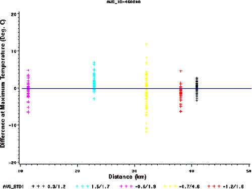
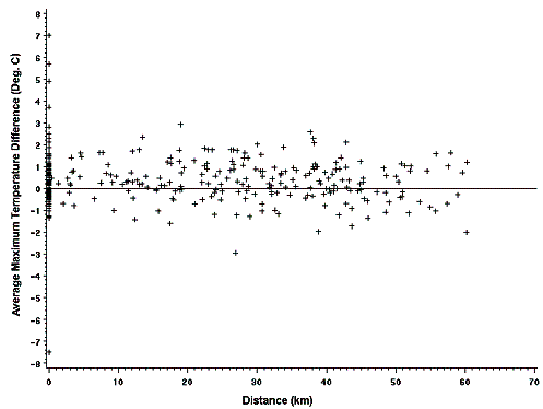
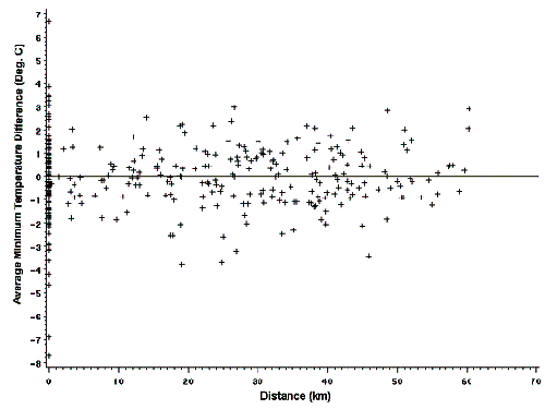
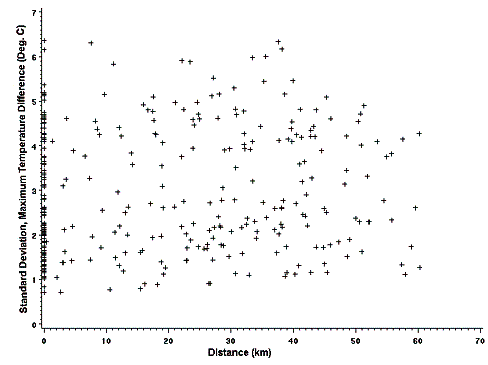
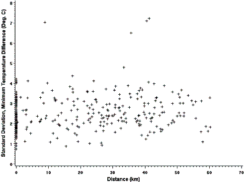
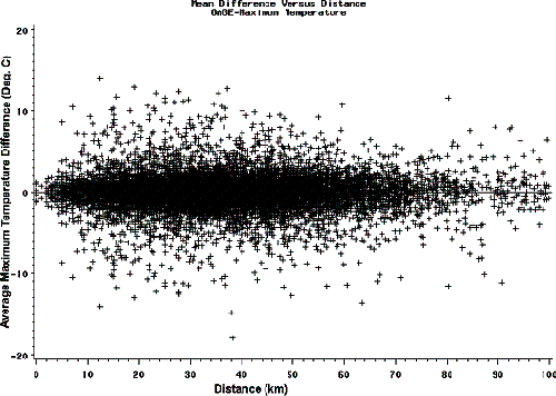
A brief explanation of each factor and their effect on the estimated temperatures are discussed below. Effects of Distance (From the Weather Station to the Site)To determine the effects of the distance from the weather station to the site on the accuracy of the estimate, the differences between the temperatures at a site and each of the five closest weather stations were determined and graphed versus distance to the site. Figure 12 shows a sample graph for the maximum temperature at site 460800. As figure 12 shows, the weather station located farthest from the site (a distance of 41 km) has a mean difference of 0.3 °C and a standard deviation of 1.2 °C. This weather station has the lowest bias and the highest precision of all of the weather stations and thus provides the most accurate estimate of maximum temperature. A study of the data for the other AWS and SMP sites reveals that the most accurate weather station is located closest to the site only one out of five times, thus making it a random event. Figures 13 through 16 show the mean and standard deviation of the temperature difference (maximum and minimum) for the five closest weather stations to the SMP and AWS sites. It can be seen from these figures that neither the precision nor the bias of the estimate is related to distance. Figures 17 through 20 show the same information for more than 5000 NCDC sites, which confirms that neither the precision nor the bias is significantly related to distance within the 60-km range.
Figure 12. Graph. Temperature difference between site 460800 and nearby weather stations versus distance.
Figure 13. Graph. Mean maximum temperature difference versus distance for AWS and SMP sites.
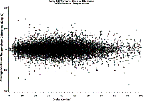
Figure 14. Graph. Mean minimum temperature difference versus distance for AWS and SMP sites.
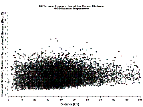
Figure 15. Graph. Standard deviation of maximum temperature difference versus distance for AWS and SMP sites.
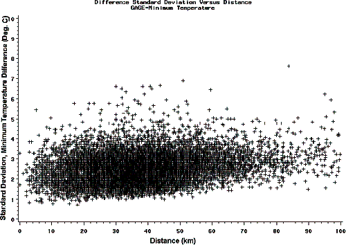
Figure 16. Graph. Standard deviation of minimum temperature difference versus distance for AWS and SMP sites.
Figure 17. Graph. Mean maximum temperature difference versus distance for NCDC sites.
Figure 18. Graph. Mean minimum temperature difference versus distance for NCDC sites.
Figure 19. Graph. Standard deviation of maximum temperature difference versus distance for NCDC sites.
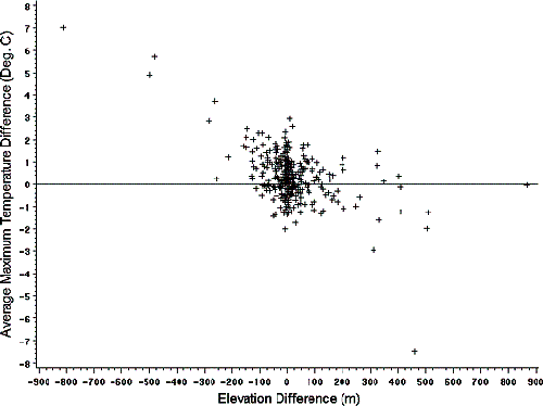
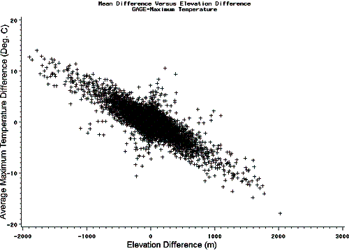
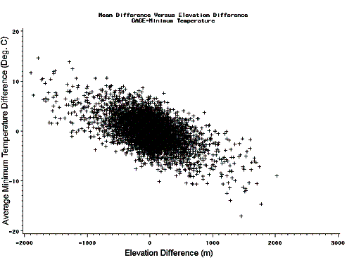
Figure 20. Graph. Standard deviation of minimum temperature difference versus distance for NCDC sites. Elevation Difference (Between the Weather Station and the Site)Graphs similar to those presented in the previous section were developed to show the effects of the elevation difference on the precision and bias of the SMP and AWS sites (see figures 21 through 25). Figures 21 and 22 show that the elevation difference affects the bias of the estimate at elevation differences higher than ±250 meters (m). On the other hand, table 26, for NCDC sites, shows that the elevation difference does not affect the precision of the estimate. For all of the NCDC weather stations, the mean and standard error of the difference between the temperature at each of the weather stations and the five closest weather stations were determined. This resulted in five average values and standard deviations for every weather station (an average of up to 1096 days of data for each weather station). Table 26 shows the average and standard deviation of the temperature difference grouped by the elevation difference. As can be seen from table 26, the mean difference (bias) for the maximum and minimum temperatures is highly related to the elevation difference. Figure 25 shows the mean temperature difference (bias) versus the elevation difference for the maximum temperature. This figure shows that the elevation difference is highly correlated with the mean temperature difference (bias). Figure 26 shows the same trend, but with higher variation for the minimum temperature. The result of this study shows that correcting for the elevation difference in the VWS calculation may substantially improve the bias of the estimate.
Figure 21. Graph. Average maximum temperature difference versus elevation difference for AWS and SMP sites.
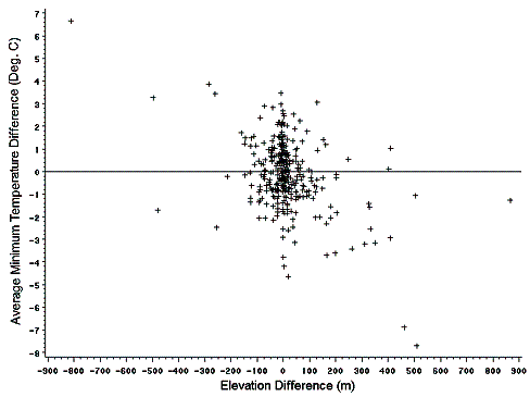
Figure 22. Graph. Average minimum temperature difference versus elevation difference for AWS and SMP sites.
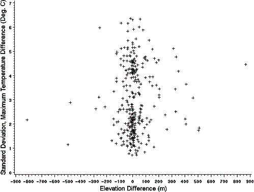
Figure 23. Graph. Standard deviation of maximum temperature difference versus elevation difference for AWS and SMP sites.
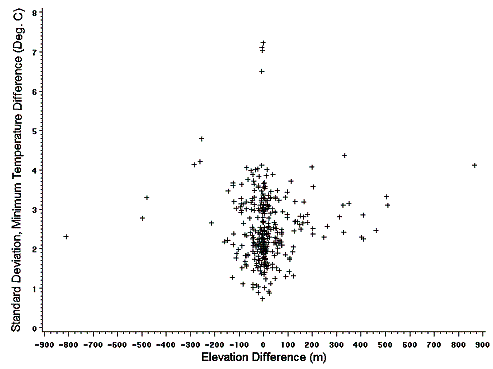
Figure 24. Graph. Standard deviation of minimum temperature difference versus elevation difference for AWS and SMP sites.
Figure 25. Graph. Mean maximum temperature difference versus elevation difference for NCDC sites.
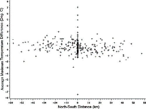
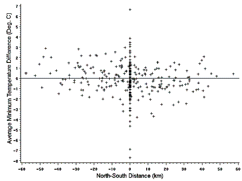
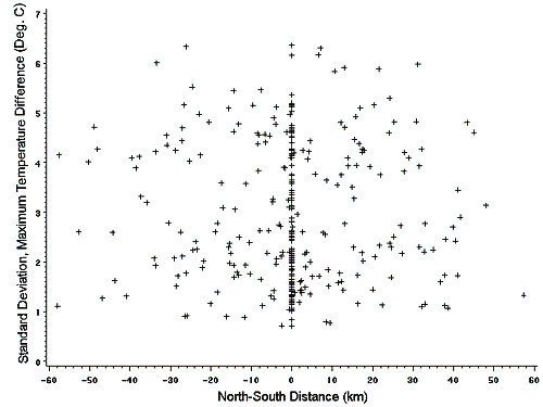
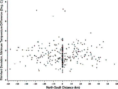
Figure 26. Graph. Mean minimum temperature difference versus elevation difference for NCDC sites. North-South Distance (Latitude) EffectsSince air temperature generally decreases when going north, this change may affect the climatic estimates from the nearby weather stations. To investigate the effects of the latitude difference, the mean and standard deviation of the temperature difference between the site and the weather stations were graphed versus the north-south distance to the weather station. The north-south distance was calculated from the distance and the bearing to the site. Figures 27 and 28 show the average temperature difference versus the north-south difference for the maximum and minimum temperatures, respectively. No particular trend was evident between the latitude and the average temperature difference (bias). Figures 29 and 30 show the standard deviation of the temperature difference versus the north-south distance. The effects of latitude on the standard deviation of the temperature difference (a measure of precision) also were not clear from these graphs. As with distance, the north-south distance does not seem to affect the precision or bias of the estimate. This may be explained by the fact that within the 60-km range, the effects of distance are mainly random. These effects may be more important at greater distances from the site.
Figure 27. Graph. Mean maximum temperature difference versus north-south distance for AWS and SMP sites.
Figure 28. Graph. Mean minimum temperature difference versus north-south distance for AWS and SMP sites.
Figure 29. Graph. Standard deviation of maximum temperature difference versus north-south distance for AWS and SMP sites.
Figure 30. Graph. Standard deviation of minimum temperature difference versus north-south distance for AWS and SMP sites. | ||||||||||||||||||||||||||||||||||||||||||||||||||||||||||||||||||||||||||||||||||||||||||||||||||||||||||||||||||||||||||||||||||||||||||||||||||||||||||||||||||||||||||||||||||||||||||||||||||||||||||||||||||||||||||||||||||||||||||||||||||||||||||||||||||||||||||||||||||||||||||||||||||||||||||||||||||||||||||||||||||||||||||||||||||||||||||||||||||||||||||||||||||||||||||||||||||||||||||||||||||||||||||||||||||||||||||||||||||||||||||||||||||||||||||||||||
| Previous | Table of Contents | Next |