U.S. Department of Transportation
Federal Highway Administration
1200 New Jersey Avenue, SE
Washington, DC 20590
202-366-4000
Federal Highway Administration Research and Technology
Coordinating, Developing, and Delivering Highway Transportation Innovations
 |
| This report is an archived publication and may contain dated technical, contact, and link information |
|
Publication Number: FHWA-RD-03-088 Date: November 2003 |
Previous | Table of Contents | Next
The Climate (CLM) module contains general environmental information from weather stations located near test sections. In addition to the measurements from these nearby weather stations, a test site-specific statistical estimate based on as many as five nearby weather stations is available. The statistical estimates are called "virtual weather stations." Raw climatic data from the operating weather stations (OWS) are stored in tables whose names begin with CLM_OWS. The virtual weather station (VWS) statistics are stored in tables whose names begin with CLM_VWS.
A substantial amount of background data is kept in offline climatic tables. Raw climatic data collected from the National Climatic Data Center (NCDC) and the Canadian Climatic Center (CCC) (for Canadian test sections) are included. These data consist of daily measurements for the LTPP selected parameters. To summarize the daily measurements, monthly and annual statistics (mean, standard deviation, minimum, maximum, count, and total) have been calculated. Selected parameters are also available as annual summaries. As of this writing, the last year for which information is included is 1996.
VWS_ID is a key field in the CLM_VWS_* data tables used to link the data from the VWS to SPS and GPS sections. Because the VWS_ID is not always the same as the combined STATE_CODE and SHRP_ID (project ID for SPS projects), CLM_SITE_VWS_LINK (and SPS_GPS_LINK, if necessary) should always be used to find AWS data for a given SPS project or GPS section.
The following CLM tables are included in the database:
CLM_SITE_VWS_LINK: This table provides the link between the VWS and the test section for which data are being provided. When an SPS section is co-located with a GPS section, the SPS section will not be in this table and the information will need to be accessed with the help of SPS_GPS_LINK .
CLM_OWS_LOCATION: This table contains the exact location of the OWS used to estimate the climatic conditions at each test section.
CLM_VWS_OWS_LINK: This table provides the link between the VWS and the associated OWS. It contains the distance between the VWS and the individual OWS, and the difference in elevation and the bearing from the VWS to the OWS.
CLM_VWS_HUMIDITY_MONTH: This table contains VWS monthly humidity statistics. The table is populated only for months with 24 or more days of data available.
CLM_VWS_HUMIDITY_ANNUAL: This table contains VWS annual humidity statistics. The table is populated only for years with 300 or more days of data available.
CLM_VWS_PRECIP_MONTH: This table contains VWS monthly precipitation statistics. The table is populated only for months with 24 or more days of data available.
CLM_VWS_PRECIP_ANNUAL: This table contains VWS annual precipitation statistics. The table is populated only for years with 300 or more days of data available.
CLM_VWS_TEMP_MONTH: This table contains VWS monthly temperature statistics. The table is populated only for months with 24 or more days of data available.
CLM_VWS_TEMP_ANNUAL: This table contains VWS annual temperature statistics. The table is populated only for years with 300 or more days of data available.
CLM_VWS_WIND_MONTH: This table contains VWS monthly wind statistics. The table is populated only for months with 24 or more days of data available.
CLM_VWS_WIND_ANNUAL: This table contains VWS annual wind statistics. The table is populated only for years with 300 or more days of data available.
The following CLM tables are not included in the database. They are stored offline; however, they are available. Please contact LTPP customer service for any of these tables.
CLM_VWS_DATA_DAILY: This table contains VWS daily data calculated from the daily OWS data. This table is stored offline.
CLM_OWS_HUMIDITY_MONTH: This table contains OWS monthly humidity statistics. The table is populated only for months with 24 or more days of data available. This table is stored offline.
CLM_OWS_HUMIDITY_ANNUAL: This table contains OWS annual humidity statistics. The table is populated only for years with 300 or more days of data available. This table is stored offline.
CLM_OWS_PRECIP_MONTH: This table contains OWS monthly precipitation statistics. The table is populated only for months with 24 or more days of data available. This table is stored offline.
CLM_OWS_PRECIP_ANNUAL: This table contains OWS annual precipitation statistics. The table is populated only for years with 300 or more days of data available. This table is stored offline.
CLM_OWS_TEMP_MONTH: This table contains OWS monthly temperature statistics. The table is populated only for months with 24 or more days of data available. This table is stored offline.
CLM_OWS_TEMP_ANNUAL: This table contains OWS annual temperature statistics. The table is populated only for years with 300 or more days of data available. This table is stored offline.
CLM_OWS_WIND_MONTH: This table contains OWS monthly wind statistics. The table is populated only for months with 24 or more days of data available. This table is stored offline.
CLM_OWS_WIND_ANNUAL: This table contains OWS annual wind statistics. The table is populated only for years with 300 or more days of data available. This table is stored offline.
CLM_OWS_DATA_DAILY: This table contains OWS daily data. This table is stored offline.
SPS_GPS_LINK: This table matches SPS maintenance and some rehabilitation projects to co-located GPS sections for which climatic data are provided.
The values in the OWS daily, monthly, and annual tables are averages from the raw climatic data mentioned in the introduction. These values form the basis for the values in the VWS tables. The VWS_DATA_DAILY table uses values from the OWS_DATA_DAILY table, the VWS_*_MONTH tables get information from the OWS_*_MONTH tables, and the VWS_*_ANNUAL tables get information from the OWS_*_ANNUAL tables.
Because the values stored in the VWS tables are computed using values from up to five different OWS locations, the following equation was used to weight the influence of OWS values based on the distance from the OWS to the VWS.
 |
(1) |
where:
Vm = calculated data element for day m for the VWSVmi= value of data element on day m for weather station i Ri = distance between weather station i and pavement project site
k = number of weather stations associated with project site (up to 5)
To compute the monthly or annual freezing index , the following equation is used:
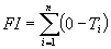 |
(2) |
where:
FI = freezing index, degrees Celsius (°C) degree-days
Ti = average daily air temperature on day i, °C
n = days in the specified period when average daily temperature is below freezing
i = number of days below freezing
When using this equation, only the days where the average daily temperature is below freezing are used. Therefore, the freezing index is the negative of the sum of all average daily temperatures below 0°C within the given period.

