U.S. Department of Transportation
Federal Highway Administration
1200 New Jersey Avenue, SE
Washington, DC 20590
202-366-4000


Skip to content
Facebook iconYouTube iconTwitter iconFlickr iconLinkedInInstagram

Federal Highway Administration Research and Technology
Coordinating, Developing, and Delivering Highway Transportation Innovations

Report
This report is an archived publication and may contain dated technical, contact, and link information
Publication Number: FHWA-RD-02-084
Date: May 2006

Highway Concrete Technology Development and Testing Volume IIi: Field Evaluation of SHRP C-205 Test Sites (High Performance Concrete)

Appendix A

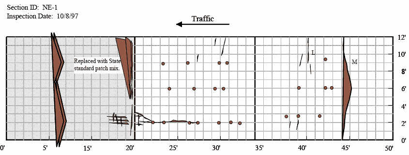
Distress survey maps representing the condition of the various patches are presented in figures 25 through 40 in this appendix. The circular dots on the maps indicate core locations. The patches in Arkansas, New York, and North Carolina did not sHow significant deterioration over time. Therefore, for these sections, distress maps are provided only for the years 1994 and 1998. On the other hand, sections in Illinois and Nebraska sHowed more pronounced deterioration over time. For these sites, distress maps are provided for all the years in which field surveys were conducted.

Figure 25. Distress map for patch, test section North Carolina 1 in1994. The figure consists of a distress map which sHows location as length of pavement in feet on the Horizontal axis and the pavement width in feet on the vertical axis. The inspection date is November 22, 1994. Patches are located at 7, 11.5, 12.5, 13.5, 16, and 17.5 feet at a pavement width of 6 feet. At a width of 5 feet, patches are located at 16, 17, and 18.5 feet. At widths of around 4 feet, there are patches at 41, 42, and 43 feet. Around a location between 51 and 52 feet, there are four patches between pavement widths of 3 and 4 feet. Around a location between 57 and 59 feet, there are 9 patches between widths of 2 and 5 feet. Around a location between 64 and 67 feet, there are seven patches between widths of 3 and 5 feet. Around between 77 and 82.5 feet, there are eight patches between widths of about 3 and 5 feet. The map also sHows a small crack extending from pavement widths of 3 to 4.5 feet located at 60 feet along the joint. The comment field states that there are no signs of D cracking or scaling.

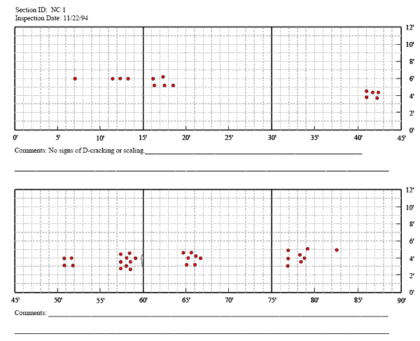
Figure 25. Graph. Distress map for patch NC-1 in North Carolina–1994.

Figure 26. Distress map for patch, test section North Carolina 1 in 1998. The figure consists of a distress map which sHows location as length of pavement in feet on the Horizontal axis and the pavement width in feet on the vertical axis. The inspection date is November 3, 1998. At a location of 7 feet and a pavement width of 6 feet, there is one patch. Located between 11.5 and 13.5 feet, there are three patches at a pavement width of 6 feet. Between 16 and 18.5 feet, there are 5 patches between pavement widths of 5 and 6 feet. Between 41 and 43 feet, there are 5 patches around pavement widths of 4 feet. Between 51 and 52 feet, there are 4 patches between pavement widths of 3 and 4 feet. Between 57 and 59 feet there are 9 patches, between 65 and 67 feet there are 7 patches, and between 77 and 82.5 feet there are 8 patches, with all patches between pavement widths of 3 and 5 feet. The map also sHows a small crack extending from 3 to 4.5 feet along the joint at 60 feet. The comment field states that there are no signs of distress cracking or scaling. There is no change in condition (1995, 1996, 1997, and 1998).

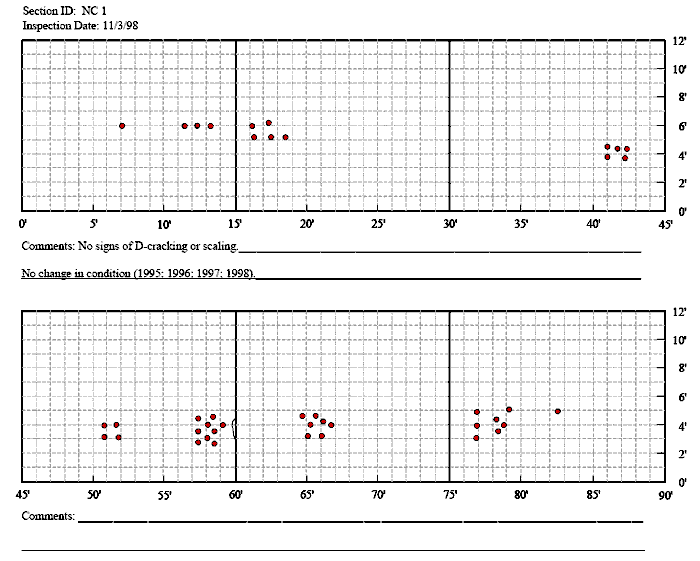
Figure 26. Graph. Distress map for patch NC-1 in North Carolina–1998.

Figure 27. Distress map for patch, test section North Carolina 2 in 1994. The figure consists of a distress map which sHows location as length of pavement in feet on the Horizontal axis and the pavement width in feet on the vertical axis. The inspection date is November 22, 1994. There is one patch located at 98 feet and a pavement width of 5 feet. Between 142 and 145.5 there are 5 patches and between 155.5 and 159 feet there are 5 patches, all between pavement widths of about 4 and 5 feet. The map also sHows a crack extending from 174 to 180 feet at a pavement width of 11 feet. The comment field states that there is a wide joint at the location of 120 feet.

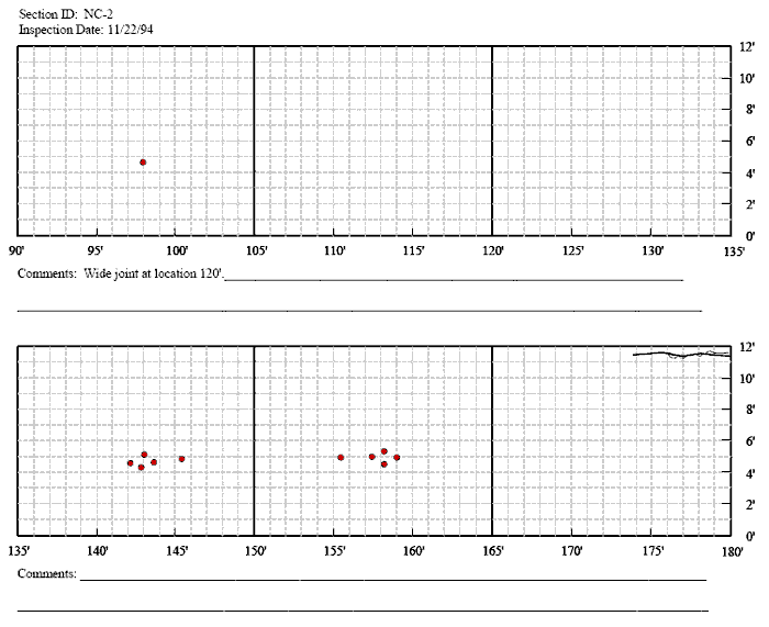
Figure 27. Graph. Distress map for patch NC-2 in North Carolina–1994.

Figure 28. Distress map for patch, test section North Carolina 2 in 1998. The figure consists of a distress map which sHows location as length of pavement in feet on the Horizontal axis and the pavement width in feet on the vertical axis. The inspection date is November 3, 1998. There is one patch at 98 feet and a pavement width of 5 feet. Between 142 and 145.5 there are 5 patches and between 155.5 and 159 feet there are 5 patches, all between pavement widths of about 4 and 5 feet. The map also sHows a crack extending from 174 to 180 feet at a pavement width of 11 feet. The comment field states that there is a wide joint at the location of 120 feet.

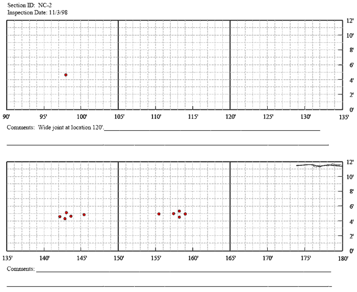
Figure 28. Graph. Distress map for patch NC-2 in North Carolina–1998.

Figure 29. Distress map for patch, test section Arkansas 1 in 1994. The figure consists of a distress map which sHows location as length of pavement in feet on the Horizontal axis and the pavement width in feet on the vertical axis and traffic flow from right to left. The inspection date is December 2, 1994. At a pavement width of 3 feet, there are patches at 8, 10, 16, 17.5, 20, 23.5, 25, 27, 40.5, and 42.5 feet. At a pavement width of 7 feet, there are patches at 10, 16.5, 20, 24, 26, 40, and 43.5 feet. At a pavement width of 9 feet, there are patches at 10, 16.5, 20, 26, and 41 feet. The map also sHows a crack extending from 25 feet to a joint at 30 feet, at a width of 1 foot. A second crack runs from the 30 foot joint to 36 feet and from a pavement width of 1 foot to 2 feet. Map cracking was noted around a pavement width of 8 to 10 feet at 25 to 28 feet. The comment field states that all joints are well sealed with HP sealant. There are no signs of scaling or distress cracking.

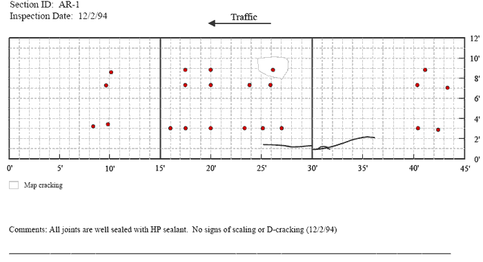
Figure 29. Graph. Distress map for patch AR-1 in Arkansas–1994.

Figure 30. Distress map for patch, test section Arkansas 1 in 1995. The figure consists of a distress map which sHows location as length of pavement in feet on the Horizontal axis and the pavement width in feet on the vertical axis and traffic flow from right to left. The inspection date is September 19, 1995. At a width of 3 feet, there are patches at 8, 10, 16, 17.5, 20, 23.5, 25, 27, 40.5, 42.5. At a width of 7 feet, there are patches at 10, 16.5, 20, 24, 26, 40, and 43.5. At a width of 8 feet, there are two patches around a length of 24 feet. At a width of 9 feet, there are patches at 10, 16.5, 20, 26, and 41. The map also sHows a crack extending from 25 feet to a joint at 30 feet, at a width of 1 foot. A second crack runs from the 30 foot joint to 36 feet, from a width of 1 foot to 2 feet. Map cracking was noted around a pavement width of 8 to 10 feet at a pavement length of 25 to 28 feet. The comment field states that there is some surface cracking noted on slab, but joint seals remain in good condition. The section was overlaid after the 1995 inspection.

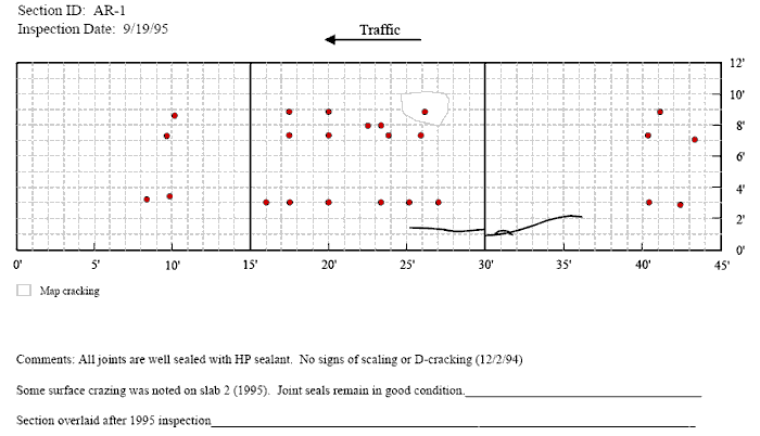
Figure 30. Graph. Distress map for patch AR-1 in Arkansas–1995.

Figure 31. Distress map for patch, test section Arkansas 2 in 1994. The figure consists of a distress map which sHows location as length of pavement in feet on the Horizontal axis and the pavement width in feet on the vertical axis and traffic flow from right to left. The inspection date is September 19, 1995. At a width of 3 feet, there are patches at 11, 13, 18, 19.5, 21.5, 23, 27, 28.5, 37, and 39.5 feet. At a width of 6.5 feet, there are patches at 11.5, 16, 21, 24, 27, and 37 feet. At a width of 9 feet there are patches at 11.5, 17.5, 21, 24, 27, and 37 feet. Map cracking was noted around a pavement width of 8 to 10.5 feet at a pavement length of 17 to 17.5 feet and a second area was noted at a width of 2 to 4 feet and a length of 17 to 17.5 feet. The comment field states that there is slight map cracking on slab number 2, but no signs of D cracking or sealing.

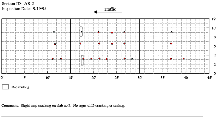
Figure 31. Graph. Distress map for patch AR-2 in Arkansas–1994.

Figure 32. Distress map for patch, test section Arkansas 2 in 1995. The figure consists of a distress map which sHows location as length of pavement in feet on the Horizontal axis and the pavement width in feet on the vertical axis and traffic flow from right to left. The inspection date is September 19, 1995. At a width of 3 feet, there are patches at 11, 13, 18, 19.5, 21.5, 23, 27, 28.5, 37, and 39.5 feet. At a width of 6.5 feet, there are patches at 11.5, 16, 21, 24, 27, and 37 feet. At a width of 9 feet there are patches at 11.5, 17.5, 21, 24, 27, and 37 feet. Map cracking was noted around a pavement width of 8 to 10.5 feet at a pavement length of 17 to 17.5 feet and a second area was noted at a width of 2 to 4 feet and a length of 17 to 17.5 feet. The comment field states that there is slight map cracking on slab number 2, but no signs of D cracking or sealing.

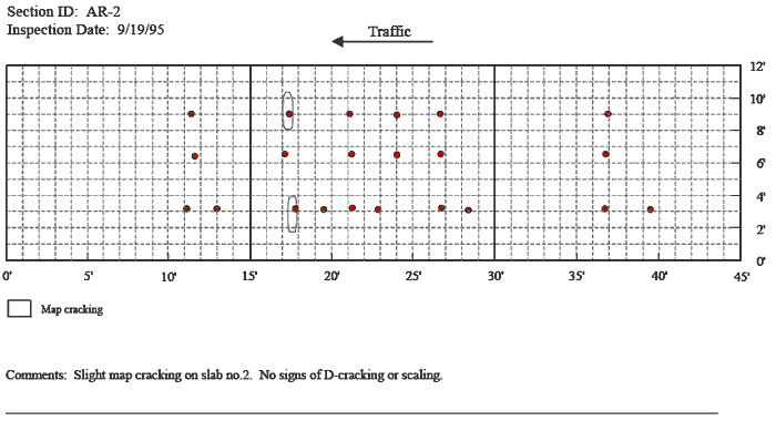
Figure 32. Graph. Distress map for patch AR-2 in Arkansas–1995.

Figure 33. Distress map of section in New York in 1994. The figure consists of a distress map which sHows location as length of pavement in feet on the Horizontal axis and the pavement width in feet on the vertical axis and traffic flow from right to left. The inspection date is November 21, 1994. There is one patch at a pavement length of 5 feet at a width of 10 feet. At 11 feet and a width of 4 feet is a single patch. Between 15 and 17 feet, there are three patches at widths of 3, 6, and 6.5 feet. At 22.5 feet there is a patch at a width of 2 feet. Between 24 and 26 feet, there are patches at 2, 2.5, 4.5, and 6 feet. Around 30 feet there are patches at 2, 4, and 6 feet. Around 32 feet, there are patches at 2, 4, and 6 feet. Around 32 feet there are patches at widths of 2 and 5 feet. At 35 feet there are patches at 2 and 5 feet. There is one patch at 36.5 feet at 2.5 feet. There is one patch at 38 feet and a width of 5.5 feet. At a width of 2 feet, there are patches at 56 and 57 feet. At a width of 4 feet, there are patches at 51 and 53 feet. There is one patch at 58 feet and a width of 6 feet. The comment field states that there is rough texture on all slabs and that the mixture was very dry when placed.

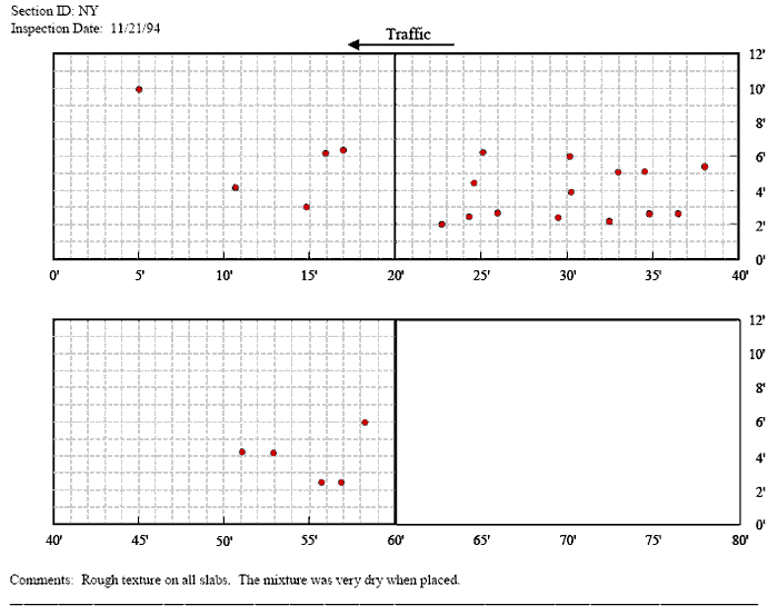
Figure 33. Graph. Distress map of section in New York–1994.

Figure 34. Distress map of section in New York in 1998. The figure consists of a distress map which sHows location as length of pavement in feet on the Horizontal axis and the pavement width in feet on the vertical axis and traffic flow from right to left. The inspection date is November 9, 1998. There is one patch at a pavement length of 5 feet at a width of 10 feet. At 11 feet and a width of 4 feet is a single patch. Between 15 and 17 feet, there are three patches at widths of 3, 6, and 6.5 feet. At 22.5 feet there is a patch at a width of 2 feet. Between 24 and 26 feet, there are patches at 2, 2.5, 4.5, and 6 feet. Around 30 feet there are patches at 2, 4, 6, and 6.5 feet. At 28.5 feet there is one patch at a width of 7 feet. Around 32 feet, there are patches at 2, 4, and 6 feet. Around 32 feet there are patches at widths of 2 and 5 feet. At 35 feet there are patches at 2 and 5 feet. There is one patch at 36.5 feet at 2.5 feet. There is one patch at 38 feet and a width of 5.5 feet. At a width of 2 feet, there are patches at 56 and 57 feet. At a width of 4 feet, there are patches at 51 and 53 feet. There is one patch at 58 feet and a width of 6 feet. The comment field states that some spalling was observed on the longitudinal edge joint around a length of 1 foot. There was also no noticeable change from the last year (1996, 1997, 1998).

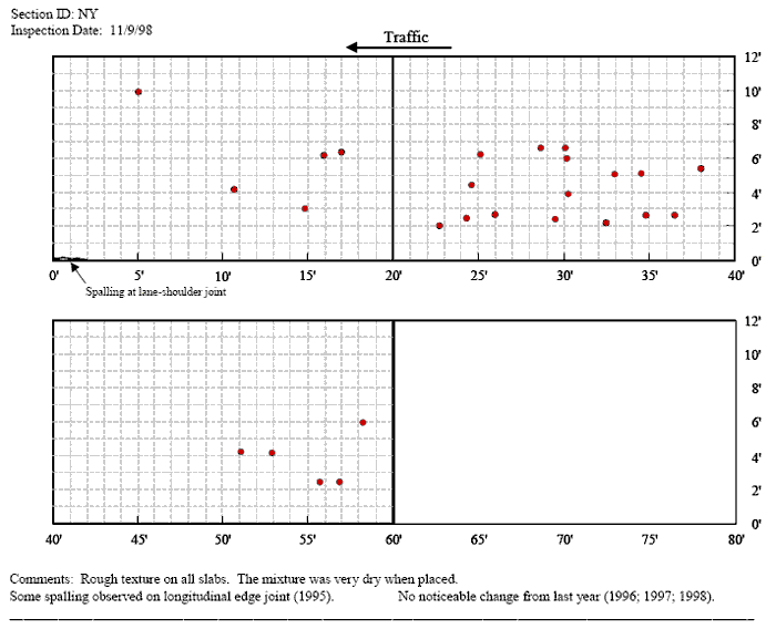
Figure 34. Graph. Distress map of section in New York–1998.

Figure 35 part 1. Distress maps for patches for test sections Illinois 1 and Illinois 2 in 1994. The figure consists of a distress map which sHows location as length of pavement in feet on the Horizontal axis and the pavement width in feet on the vertical axis and traffic flow from left to right. The inspection date is November 9, 1998 for the Illinois 1 section. Between widths of 2 and 3 feet, there are patches at 6, 7, 9.5, 18, 18.5, 19, 20, 20.5, 21, 25, 25.5, 26, 35, 35.5, 37, and 38 feet. At a width of 6 feet, there are patches at 8, 18, 19, 21, 22, 23, 24, 26, and 36 feet. There are also three indentations between 18 and 21 feet at a pavement width of 11 feet and two single indentations at 36 and 44 feet at a width of 1 foot. There is also a high and low severity transverse crack of about 2.5 feet at 20 feet between a width of 7 and 10 feet, and another high and low severity transverse crack that is about 6 feet in length at 21 to 22 feet and between pavement widths of 1 and 6 feet. There is an additional high and low severity transverse crack about 3 feet in length at 37 feet and a pavement width between 1 and 4 feet. The comment field states that the section is insulated and some scaling is present which appears to be construction related. The finish is also cleaner than the Illinois 2 site. The Illinois 2 site has an inspection date of October 20, 1994. At a pavement width of 3 feet, there are three patches located between 8 and 10 feet, 14 patches between 20 and 28 feet, three patches between 35 and 36.5 feet. At a width of 6.5 feet, there is one patch at 8.5 feet, 6 patches from 21 to 26.5 feet, and one patch at 37.5 feet. There are two, one foot longitudinal cracks located between 3 and 7 feet at a pavement width of 6 feet. There is a one foot transverse crack located at 8 feet and a pavement width of 10 feet. There is another 1 foot transverse crack located at 8 feet and a pavement width of 11 feet. There is one low severity level transverse crack located at 23 feet that extends from pavement widths of 4 to 12 feet.  There are two crack located at 37 feet between a pavement width of 1 and 3 feet, and 6 and 7 feet. There are 6 patches of scaling or map cracking, one is located between 0 and 3 feet and a pavement width between 5 and 8 feet, another is located between 6 and 7 feet at a pavement width of 6 and 7 feet, another is located at 9 feet between pavement widths of 10 and 11 feet, another at 19 feet and a pavement width of 5 feet, another is located at 34 feet and between pavement widths of 9 and 10 feet, and the last one is located at 37 feet between pavement widths of 7 and 9 feet. The comment field states that the site is not insulated and there are shrinkage cracks, minor map cracking, and scaling. The surrounding pavement had been milled.

Figure 35. Distress maps for patches for test sections Illinois 1 and Illinois 2 in 1994. The figure consists of a distress map which sHows location as length of pavement in feet on the Horizontal axis and the pavement width in feet on the vertical axis and traffic flow from left to right. The inspection date is November 9, 1998 for the Illinois 1 section. Between widths of 2 and 3 feet, there are patches at 6, 7, 9.5, 18, 18.5, 19, 20, 20.5, 21, 25, 25.5, 26, 35, 35.5, 37, and 38 feet. At a width of 6 feet, there are patches at 8, 18, 19, 21, 22, 23, 24, 26, and 36 feet. There are also three indentations between 18 and 21 feet at a pavement width of 11 feet and two single indentations at 36 and 44 feet at a width of 1 foot. There is also a high and low severity transverse crack of about 2.5 feet at 20 feet between a width of 7 and 10 feet, and another high and low severity transverse crack that is about 6 feet in length at 21 to 22 feet and between pavement widths of 1 and 6 feet. There is an additional high and low severity transverse crack about 3 feet in length at 37 feet and a pavement width between 1 and 4 feet. The comment field states that the section is insulated and some scaling is present which appears to be construction related. The finish is also cleaner than the Illinois 2 site. The Illinois 2 site has an inspection date of October 20, 1994. At a pavement width of 3 feet, there are three patches located between 8 and 10 feet, 14 patches between 20 and 28 feet, three patches between 35 and 36.5 feet. At a width of 6.5 feet, there is one patch at 8.5 feet, 6 patches from 21 to 26.5 feet, and one patch at 37.5 feet. There are two, one foot longitudinal cracks located between 3 and 7 feet at a pavement width of 6 feet. There is a one foot transverse crack located at 8 feet and a pavement width of 10 feet. There is another 1 foot transverse crack located at 8 feet and a pavement width of 11 feet. There is one low severity level transverse crack located at 23 feet that extends from pavement widths of 4 to 12 feet.  There are two crack located at 37 feet between a pavement width of 1 and 3 feet, and 6 and 7 feet. There are 6 patches of scaling or map cracking, one is located between 0 and 3 feet and a pavement width between 5 and 8 feet, another is located between 6 and 7 feet at a pavement width of 6 and 7 feet, another is located at 9 feet between pavement widths of 10 and 11 feet, another at 19 feet and a pavement width of 5 feet, another is located at 34 feet and between pavement widths of 9 and 10 feet, and the last one is located at 37 feet between pavement widths of 7 and 9 feet. The comment field states that the site is not insulated and there are shrinkage cracks, minor map cracking, and scaling. The surrounding pavement had been milled.

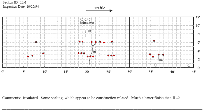
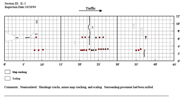
Figure 35. Graph. Distress maps for patches IL-1 and IL-2 in Illinois–1994.

Figure 36. Distress maps for patches IL-1 and IL-2 in Illinois, 1995. The figure consists of a distress map which sHows location as length of pavement in feet on the Horizontal axis and the pavement width in feet on the vertical axis and traffic flow from left to right. The inspection date is September 11, 1995 for the Illinois 1 section. At a pavement width between 2 and 3.5 feet, there are two patches located between 6 and 7 feet, 1 located at 9 feet, 6 located between 18 and 22 feet, three between 25 and 27 feet, 4 between 35 and 38 feet. At a pavement with of 6 feet, there is one patch located at 8 feet, two located between 18 and 19 feet, four between 21 and 24 feet, one at 26 feet, and one at 36 feet. There is one low level transverse crack at 9 feet between pavement widths of 3.5 and 5 feet. There is one low level transverse crack located at 20 feet between 7 and 9.5 feet. There is a long transverse crack, low level, located between 21 and 22 feet and between pavement widths of 0.5 and 6 feet. There is one low level transverse crack located at 24 feet, between pavement widths of 4 and 5.5 feet. There is one low level transverse crack located at 37 feet between pavement widths of 2 and 4 feet. There is a notation that there are three indentations located between 18 and 21 feet at a pavement width of 11 feet. There are two indentations located 36 and 44 feet at a pavement width of 0.5 feet. The comment field states that the section is insulated and some scaling is present which appears to be construction related. The finish is also cleaner than the Illinois 2 site. The Illinois 2 site has an inspection date of September 11, 1995. At a pavement width of 3 feet, there are three patches located between 8 and 10 feet, 14 patches between 20 and 28 feet, three patches between 35 and 36.5 feet. At a width of 6.5 feet, there is one patch at 8.5 feet, 6 patches from 21 to 26.5 feet, and one patch at 37.5 feet. There are two, one foot longitudinal cracks located between 3 and 7 feet at a pavement width of 6 feet. There is a one foot longitudinal crack located at 8 feet and a pavement width of 7 feet. There are three, one foot transverse cracks located at 8.5 feet, at pavement widths of 3, 5, and 10 feet. There is one low severity level transverse crack located at 23 feet that extends from pavement widths of 4 to 12 feet.  There are two crack located at 37 feet between a pavement width of 1 and 3 feet, and 6 and 7 feet. There are 6 patches of scaling or map cracking, one is located between 0 and 3 feet and a pavement width between 5 and 8 feet, another is located between 6 and 7 feet at a pavement width of 6 and 7 feet, another is located at 9 feet between pavement widths of 10 and 11 feet, another at 19 feet and a pavement width of 5 feet, another is located at 34 feet and between pavement widths of 9 and 10 feet, and the last one is located at 37 feet between pavement widths of 7 and 9 feet. The comment field states that the site is not insulated and there are shrinkage cracks, minor map cracking, and scaling. The surrounding pavement had been milled.

Figure 36. Distress maps for patches IL-1 and IL-2 in Illinois, 1995. The figure consists of a distress map which sHows location as length of pavement in feet on the Horizontal axis and the pavement width in feet on the vertical axis and traffic flow from left to right. The inspection date is September 11, 1995 for the Illinois 1 section. At a pavement width between 2 and 3.5 feet, there are two patches located between 6 and 7 feet, 1 located at 9 feet, 6 located between 18 and 22 feet, three between 25 and 27 feet, 4 between 35 and 38 feet. At a pavement with of 6 feet, there is one patch located at 8 feet, two located between 18 and 19 feet, four between 21 and 24 feet, one at 26 feet, and one at 36 feet. There is one low level transverse crack at 9 feet between pavement widths of 3.5 and 5 feet. There is one low level transverse crack located at 20 feet between 7 and 9.5 feet. There is a long transverse crack, low level, located between 21 and 22 feet and between pavement widths of 0.5 and 6 feet. There is one low level transverse crack located at 24 feet, between pavement widths of 4 and 5.5 feet. There is one low level transverse crack located at 37 feet between pavement widths of 2 and 4 feet. There is a notation that there are three indentations located between 18 and 21 feet at a pavement width of 11 feet. There are two indentations located 36 and 44 feet at a pavement width of 0.5 feet. The comment field states that the section is insulated and some scaling is present which appears to be construction related. The finish is also cleaner than the Illinois 2 site. The Illinois 2 site has an inspection date of September 11, 1995. At a pavement width of 3 feet, there are three patches located between 8 and 10 feet, 14 patches between 20 and 28 feet, three patches between 35 and 36.5 feet. At a width of 6.5 feet, there is one patch at 8.5 feet, 6 patches from 21 to 26.5 feet, and one patch at 37.5 feet. There are two, one foot longitudinal cracks located between 3 and 7 feet at a pavement width of 6 feet. There is a one foot longitudinal crack located at 8 feet and a pavement width of 7 feet. There are three, one foot transverse cracks located at 8.5 feet, at pavement widths of 3, 5, and 10 feet. There is one low severity level transverse crack located at 23 feet that extends from pavement widths of 4 to 12 feet.  There are two crack located at 37 feet between a pavement width of 1 and 3 feet, and 6 and 7 feet. There are 6 patches of scaling or map cracking, one is located between 0 and 3 feet and a pavement width between 5 and 8 feet, another is located between 6 and 7 feet at a pavement width of 6 and 7 feet, another is located at 9 feet between pavement widths of 10 and 11 feet, another at 19 feet and a pavement width of 5 feet, another is located at 34 feet and between pavement widths of 9 and 10 feet, and the last one is located at 37 feet between pavement widths of 7 and 9 feet. The comment field states that the site is not insulated and there are shrinkage cracks, minor map cracking, and scaling. The surrounding pavement had been milled.

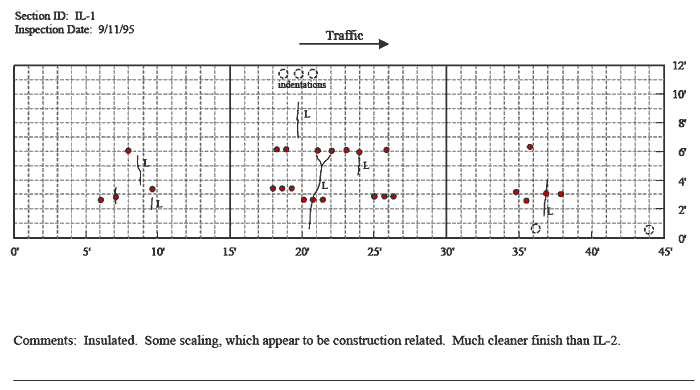
Figure 36. Graph. Distress maps for patches IL-1 and IL-2 in Illinois–1995.

Distress maps for patches IL-1 and IL-2 in Illinois, 1996. The figure consists of a distress map which sHows location as length of pavement in feet on the Horizontal axis and the pavement width in feet on the vertical axis and traffic flow from left to right. The inspection date is October 11, 1996 for the Illinois 1 section. At a pavement width between 2 and 3.5 feet, there are two patches located between 6 and 7 feet, 1 located at 9 feet, 6 located between 18 and 22 feet, three between 25 and 27 feet, and 4 between 35 and 38 feet. At a pavement with of 6 feet, there is one patch located at 8 feet, two located between 18 and 19 feet, four between 21 and 24 feet, three between 26 and 27 feet, and one at 36 feet. There is one low level crack located at 5 feet that runs from pavement widths of 0 to 20 feet and another at 5 feet that runs from 2 to 4 feet. There is one transverse crack at 7 feet between 2 and 3.5 feet. There is one low level transverse crack at 9 feet between pavement widths of 3.5 and 5 feet. There is one low level transverse crack located at 9.5 feet between pavement widths of 2 and 3 feet. There is one low level transverse crack located at 19.5 feet extending from a pavement with of 7 to 9.5. There is one low level transverse crack located at 20 feet between 1 and 6 feet. There is one transverse crack located at 19 feet that runs between 6 and 10.5. There is one low level transverse crack located at 24 feet, between pavement widths of 1 and 3 feet and another between 4 and 5.5 feet. There is one low level transverse crack located at 37 feet between pavement widths of 2 and 4 feet. There is a notation that there are three indentations located between 18 and 21 feet at a pavement width of 11 feet. There are two indentations located 36 and 44 feet at a pavement width of 0.5 feet. The comment field states that the section is insulated and some scaling is present which appears to be construction related. The finish is also cleaner than the Illinois 2 site. The Illinois 2 site has an inspection date of October 11, 1996. At a pavement width of 3 feet, there are three patches located between 8 and 10 feet, 14 patches between 20 and 28 feet, and three patches between 35 and 36.5 feet. At a width of 6.5 feet, there is one patch at 8.5 feet, 6 patches from 21 to 26.5 feet, and one patch at 37.5 feet. There are two, one foot longitudinal cracks located between 3 and 7 feet at a pavement width of 6 feet. There is a one foot longitudinal crack located at 8 feet and a pavement width of 7 feet. There are three, one foot transverse cracks located at 8.5 feet, at pavement widths of 3, 5, and 10 feet. There is one transverse crack located at 5 feet that extends from a width of 0 to 4 feet. There is one low severity level transverse crack located at 23 feet that extends from pavement widths of 4 to 12 feet.  There are two crack located at 37 feet between a pavement width of 1 and 3 feet and 6 and 7 feet. There are 6 patches of scaling or map cracking, one is located between 0 and 3 feet and a pavement width between 5 and 8 feet, another is located between 6 and 7 feet at a pavement width of 6 and 7 feet, another is located at 9 feet between pavement widths of 10 and 11 feet, another at 19 feet and a pavement width of 5 feet, another is located at 34 feet and between pavement widths of 9 and 10 feet, and the last one is located at 37 feet between pavement widths of 7 and 9 feet. The comment field states that the site is not insulated and there are shrinkage cracks, minor map cracking, and scaling. The surrounding pavement had been milled.

Figure 37 part 2. Description is the same as that for Distress maps in part 1.

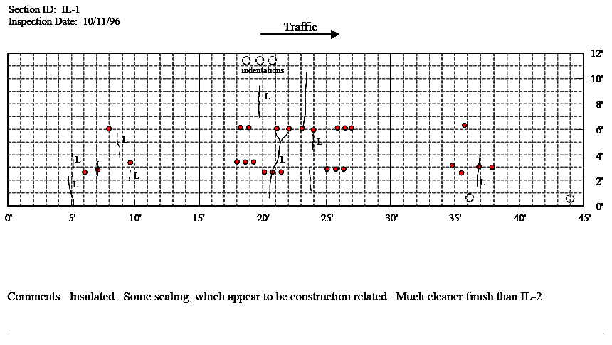
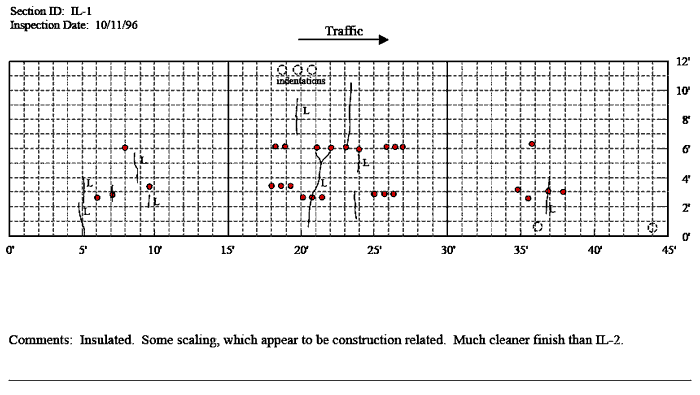
Figure 37. Graph. Distress maps for patches IL-1 and IL-2 in Illinois–1996.

Figure 38. Distress maps for patches IL-1 and IL-2 in Illinois, 1997. The figure consists of a distress map which sHows location as length of pavement in feet on the Horizontal axis and the pavement width in feet on the vertical axis and traffic flow from left to right. The inspection date is January 12, 1998 for the Illinois 1 section. At a pavement width between 2 and 3.5 feet, there are two patches located between 6 and 7 feet, 1 located at 9 feet, 6 located between 18 and 22 feet, three between 25 and 27 feet, and 4 between 35 and 38 feet. At a pavement with of 6 feet, there is one patch located at 8 feet, two located between 18 and 19 feet, four between 21 and 24 feet, three between 26 and 27 feet, and one at 36 feet. There is one low level crack located at 5 feet that runs from pavement widths of 0 to 20 feet and another at 5 feet that runs from 2 to 4 feet. There is one transverse crack at 7 feet between 2 and 3.5 feet. There is one low level transverse crack at 9 feet between pavement widths of 3.5 and 5 feet. There is one low level transverse crack located at 9.5 feet between pavement widths of 2 and 3 feet. There is one low level transverse crack located at 19.5 feet extending from a pavement with of 7 to 9.5. There is one low level transverse crack located at 20 feet between 1 and 6 feet. There is one transverse crack located at 19 feet that runs between 6 and 10.5. There is one low level transverse crack located at 24 feet, between pavement widths of 1 and 3 feet and another between 4 and 5.5 feet. There is one low level transverse crack located at 37 feet between pavement widths of 2 and 4 feet. There is a notation that there are three indentations located between 18 and 21 feet at a pavement width of 11 feet. There are two indentations located 36 and 44 feet at a pavement width of 0.5 feet. The comment field states that the section is insulated and some scaling is present which appears to be construction related. The finish is also cleaner than the Illinois 2 site. It is also noted that there is a slight increase in map cracking since 1997. The Illinois 2 site has an inspection date of January 12, 1998. At a pavement width of 3 feet, there are three patches located between 8 and 10 feet, 14 patches between 20 and 28 feet, and three patches between 35 and 36.5 feet. At a width of 6.5 feet, there is one patch at 8.5 feet, 6 patches from 21 to 26.5 feet, and one patch at 37.5 feet. There are two, one foot longitudinal cracks located between 3 and 7 feet at a pavement width of 6 feet. There is a one foot longitudinal crack located at 8 feet and a pavement width of 7 feet. There are three, one foot transverse cracks located at 8.5 feet, at pavement widths of 3, 5, and 10 feet. There is one transverse crack located at 5 feet that extends from a width of 0 to 4 feet. There is one low severity level transverse crack located at 23 feet that extends from pavement widths of 4 to 12 feet.  There are two crack located at 37 feet between a pavement width of 1 and 3 feet and 6 and 7 feet. There are 6 patches of scaling or map cracking, one is located between 0 and 3 feet and a pavement width between 5 and 8 feet, another is located between 6 and 7 feet at a pavement width of 6 and 7 feet, another is located at 9 feet between pavement widths of 10 and 11 feet, another at 19 feet and a pavement width of 5 feet, another is located at 34 feet and between pavement widths of 9 and 10 feet, and the last one is located at 37 feet between pavement widths of 7 and 9 feet. The comment field states that the site is not insulated and there are shrinkage cracks, minor map cracking, and scaling. The surrounding pavement had been milled. It is noted that there is a slight increase in map cracking since 1997.

Figure 38. Distress maps for patches IL-1 and IL-2 in Illinois, 1997. The figure consists of a distress map which sHows location as length of pavement in feet on the Horizontal axis and the pavement width in feet on the vertical axis and traffic flow from left to right. The inspection date is January 12, 1998 for the Illinois 1 section. At a pavement width between 2 and 3.5 feet, there are two patches located between 6 and 7 feet, 1 located at 9 feet, 6 located between 18 and 22 feet, three between 25 and 27 feet, and 4 between 35 and 38 feet. At a pavement with of 6 feet, there is one patch located at 8 feet, two located between 18 and 19 feet, four between 21 and 24 feet, three between 26 and 27 feet, and one at 36 feet. There is one low level crack located at 5 feet that runs from pavement widths of 0 to 20 feet and another at 5 feet that runs from 2 to 4 feet. There is one transverse crack at 7 feet between 2 and 3.5 feet. There is one low level transverse crack at 9 feet between pavement widths of 3.5 and 5 feet. There is one low level transverse crack located at 9.5 feet between pavement widths of 2 and 3 feet. There is one low level transverse crack located at 19.5 feet extending from a pavement with of 7 to 9.5. There is one low level transverse crack located at 20 feet between 1 and 6 feet. There is one transverse crack located at 19 feet that runs between 6 and 10.5. There is one low level transverse crack located at 24 feet, between pavement widths of 1 and 3 feet and another between 4 and 5.5 feet. There is one low level transverse crack located at 37 feet between pavement widths of 2 and 4 feet. There is a notation that there are three indentations located between 18 and 21 feet at a pavement width of 11 feet. There are two indentations located 36 and 44 feet at a pavement width of 0.5 feet. The comment field states that the section is insulated and some scaling is present which appears to be construction related. The finish is also cleaner than the Illinois 2 site. It is also noted that there is a slight increase in map cracking since 1997. The Illinois 2 site has an inspection date of January 12, 1998. At a pavement width of 3 feet, there are three patches located between 8 and 10 feet, 14 patches between 20 and 28 feet, and three patches between 35 and 36.5 feet. At a width of 6.5 feet, there is one patch at 8.5 feet, 6 patches from 21 to 26.5 feet, and one patch at 37.5 feet. There are two, one foot longitudinal cracks located between 3 and 7 feet at a pavement width of 6 feet. There is a one foot longitudinal crack located at 8 feet and a pavement width of 7 feet. There are three, one foot transverse cracks located at 8.5 feet, at pavement widths of 3, 5, and 10 feet. There is one transverse crack located at 5 feet that extends from a width of 0 to 4 feet. There is one low severity level transverse crack located at 23 feet that extends from pavement widths of 4 to 12 feet.  There are two crack located at 37 feet between a pavement width of 1 and 3 feet and 6 and 7 feet. There are 6 patches of scaling or map cracking, one is located between 0 and 3 feet and a pavement width between 5 and 8 feet, another is located between 6 and 7 feet at a pavement width of 6 and 7 feet, another is located at 9 feet between pavement widths of 10 and 11 feet, another at 19 feet and a pavement width of 5 feet, another is located at 34 feet and between pavement widths of 9 and 10 feet, and the last one is located at 37 feet between pavement widths of 7 and 9 feet. The comment field states that the site is not insulated and there are shrinkage cracks, minor map cracking, and scaling. The surrounding pavement had been milled. It is noted that there is a slight increase in map cracking since 1997.

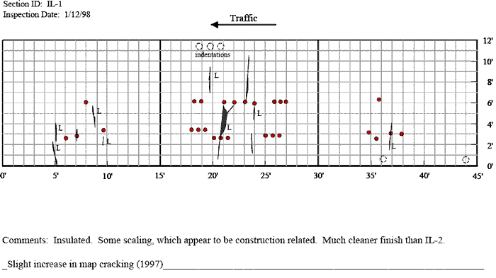
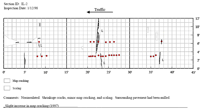
Figure 38. Graph. Distress maps for patches IL-1 and IL-2 in Illinois–1997.

Figure 39 part 1. Distress maps for patches IL-1 and IL-2 in Illinois, 1998. The figure consists of a distress map which sHows location as length of pavement in feet on the Horizontal axis and the pavement width in feet on the vertical axis and traffic flow from left to right. The inspection date is January 12, 1998 for the Illinois 1 section. At a pavement width between 2 and 3.5 feet, there are two patches located between 6 and 7 feet, 1 located at 9 feet, 6 located between 18 and 22 feet, three between 25 and 27 feet, and 4 between 35 and 38 feet. At a pavement with of 6 feet, there is one patch located at 8 feet, two located between 18 and 19 feet, four between 21 and 24 feet, three between 26 and 27 feet, and one at 36 feet. There is one low level crack located at 5 feet that runs from pavement widths of 0 to 20 feet and another at 5 feet that runs from 2 to 4 feet. There is one transverse crack at 7 feet between 2 and 3.5 feet. There is one low level transverse crack at 9 feet between pavement widths of 3.5 and 5 feet. There is one low level transverse crack located at 9.5 feet between pavement widths of 2 and 3 feet. There is one low level transverse crack located at 19.5 feet extending from a pavement with of 7 to 9.5. There is one low level transverse crack located at 20 feet between 1 and 6 feet. There is one transverse crack located at 19 feet that runs between 6 and 10.5. There is one low level transverse crack located at 24 feet, between pavement widths of 1 and 3 feet and another between 4 and 5.5 feet. There is one low level transverse crack located at 37 feet between pavement widths of 2 and 4 feet. There is a notation that there are three indentations located between 18 and 21 feet at a pavement width of 11 feet. There are two indentations located 36 and 44 feet at a pavement width of 0.5 feet. The comment field states that the section is insulated and some scaling is present which appears to be construction related. The finish is also cleaner than the Illinois 2 site. It is also noted that there is a slight increase in map cracking since 1997. The Illinois 2 site has an inspection date of January 12, 1998. At a pavement width of 3 feet, there are three patches located between 8 and 10 feet, 14 patches between 20 and 28 feet, and three patches between 35 and 36.5 feet. At a width of 6.5 feet, there is one patch at 8.5 feet, 6 patches from 21 to 26.5 feet, and one patch at 37.5 feet. There are two, one foot longitudinal cracks located between 3 and 7 feet at a pavement width of 6 feet. There is a one foot longitudinal crack located at 8 feet and a pavement width of 7 feet. There are three, one foot transverse cracks located at 8.5 feet, at pavement widths of 3, 5, and 10 feet. There is one transverse crack located at 5 feet that extends from a width of 0 to 4 feet. There is one low severity level transverse crack located at 23 feet that extends from pavement widths of 4 to 12 feet.  There are two crack located at 37 feet between a pavement width of 1 and 3 feet and 6 and 7 feet. There are 6 patches of scaling or map cracking, one is located between 0 and 3 feet and a pavement width between 5 and 8 feet, another is located between 6 and 7 feet at a pavement width of 6 and 7 feet, another is located at 9 feet between pavement widths of 10 and 11 feet, another at 19 feet and a pavement width of 5 feet, another is located at 34 feet and between pavement widths of 9 and 10 feet, and the last one is located at 37 feet between pavement widths of 7 and 9 feet. The comment field states that the site is not insulated and there are shrinkage cracks, minor map cracking, and scaling. The surrounding pavement had been milled. It is noted that there is a slight increase in map cracking since 1997.

figure 39 part 2. Description is the same as for Distress Maps 1

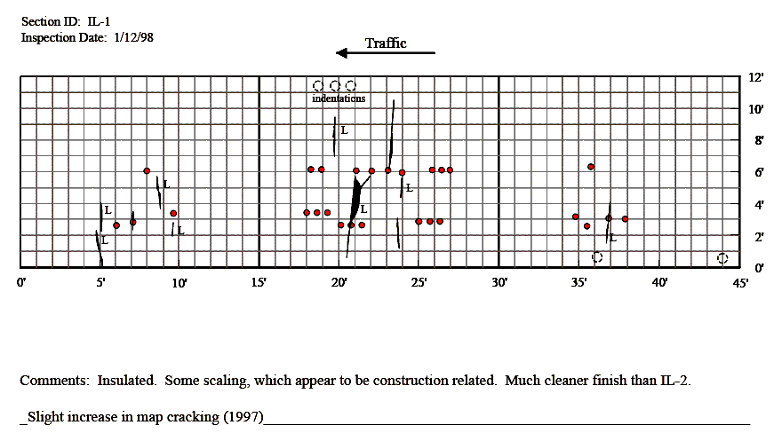
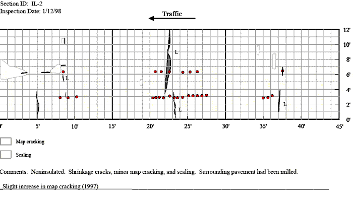
Figure 39. Graph. Distress maps for patches IL-1 and IL-2 in Illinois–1998.

Figure 40 part 1. Distress maps for patches NE-1 and NE-2 in Nebraska, 1994. The figure consists of a distress map which sHows location as length of pavement in feet on the Horizontal axis and the pavement width in feet on the vertical axis and traffic flow from left to right. The inspection date is October 1, 1994 for the Nebraska 1 section. The pavement section from 0 to 20 feet was replaced with the State’s standard pavement mix. There are six patches between 17 and 30 feet at a pavement with of 3 feet. There are three patches between 37 and 42 feet between widths of 2 and 3 feet. At a pavement width of 6 feet, there are patches at 24, 27, 29, 30, 39, 42, and 43 feet. At a pavement width of 9 feet, there are patches located at 23, 27, 30, 31, and 42 feet. There are two one foot transverse cracks at 27 and 29 feet between pavement widths of 9 and 12 feet. There is a one foot transverse crack located at 38 feet between 1 and 2 feet. There is a one foot transverse crack located at 41 feet between widths of 5.5 and 6.5 feet. There is one low level transverse crack located at 41 feet between widths of 9 and 12 feet. There is one medium level transverse crack that extends completely across the pavement at 44 feet. The comment field states that the section is located 700 west of Breslav Creek Bridge. For the Nebraska 2 section, the inspection date is October 11, 1994. At pavement widths between 3 and 4 feet, there are patches located at 4, 6, 7, 17, 18, 22, 23, 25, 30, 37, 38, and 40 feet. At a pavement width of 6 feet, there are patches located at 5.5, 19, 22.5, 25, 29, 37, and 40 feet. At a pavement width of 9 feet, there are patches located at 7.5, 19, 25, 29.5, and 37 feet. There is on medium level transverse crack that extends completely across the pavement at 10 feet and another at 40 feet.

Figure 40 part 2. Description for distress maps is the same as for part 1.

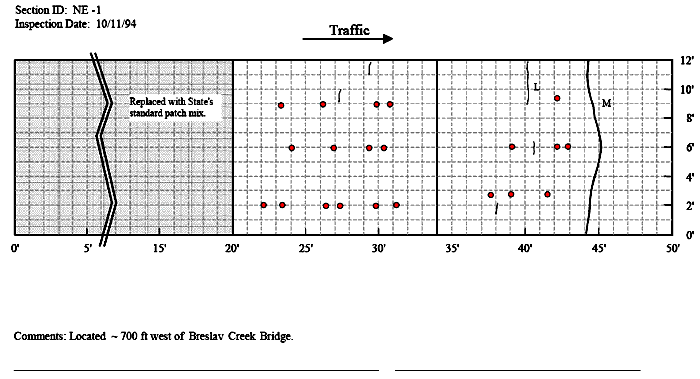
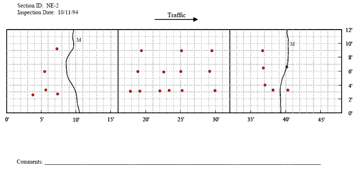
Figure 40. Graph. Distress maps for patches NE-1 and NE-2 in Nebraska–1994.

Figure 41 part 1. Distress maps for patches NE-1 and NE-2 in Nebraska, 1995. The figure consists of a distress map which sHows location as length of pavement in feet on the Horizontal axis and the pavement width in feet on the vertical axis and traffic flow from left to right. The inspection date is September 19, 1995 for the Nebraska 1 section. The pavement section from 0 to 20 feet was replaced with the State’s standard pavement mix. There are six patches between 17 and 30 feet at a pavement with of 3 feet. There are three patches between 37 and 42 feet between widths of 2 and 3 feet. At a pavement width of 6 feet, there are patches at 24, 27, 29, 30, 39, 42, and 43 feet. At a pavement width of 9 feet, there are patches located at 23, 27, 30, 31, and 42 feet. There are two one foot transverse cracks at 27 and 29 feet between pavement widths of 9 and 12 feet. There is a one foot transverse crack located at 38 feet between 1 and 2 feet. There is one low level transverse crack located at 41 feet between widths of 9 and 12 feet. There is one medium level transverse crack that extends completely across the pavement at 44 feet. The comment field states that the section is located 700 west of Breslav Creek Bridge and there is no significant change in condition since 1995. For the Nebraska 2 section, the inspection date is September 18, 1995. At pavement widths between 3 and 4 feet, there are patches located at 4, 6, 7, 17, 18, 22, 23, 25, 30, 37, 38, and 40 feet. At a pavement width of 6 feet, there are patches located at 5.5, 19, 22.5, 25, 29, 37, and 40 feet. At a pavement width of 9 feet, there are patches located at 7.5, 19, 25, 29.5, and 37 feet. There is on medium level transverse crack that extends completely across the pavement at 10 feet and another at 40 feet. At a location of 2 feet there are two transverse cracks, one between 11 and 12 feet, and one between 8 and 10 feet. At 24 feet, there are three transverse cracks between 3 and 4 feet, 5 and 7 feet, and 9 and 11 feet. There is an area of map cracking between 36 and 43 feet between pavement widths of 10 and 12 feet.

Figurure 41 part 2. Description for distress maps is the same as for part 1.

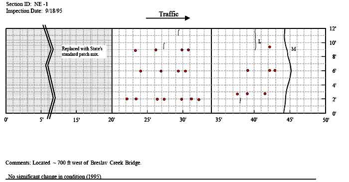
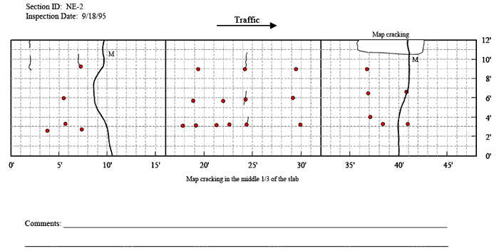
Figure 41. Graph. Distress maps for patches NE-1 and NE-2 in Nebraska–1995.

Figure 42. Distress maps for patches NE-1 and NE-2 in Nebraska, 1996. The figure consists of a distress map which sHows location as length of pavement in feet on the Horizontal axis and the pavement width in feet on the vertical axis and traffic flow from left to right. The inspection date is September 26, 1996 for the Nebraska 1 section. The pavement section from 0 to 20 feet was replaced with the State’s standard pavement mix. There are six patches between 17 and 30 feet at a pavement with of 3 feet. There are three patches between 37 and 42 feet between widths of 2 and 3 feet. At a pavement width of 6 feet, there are patches at 24, 27, 29, 30, 39, 42, and 43 feet. At a pavement width of 9 feet, there are patches located at 23, 27, 30, 31, and 42 feet. There is one longitudinal crack that extends from 24 to 27 feet at a pavement width of 2 feet. There is one transverse crack located at 30 feet that extends from 10 to 12 feet. There are two one foot transverse cracks at 27 and 29 feet between pavement widths of 9 and 12 feet. There is a one foot transverse crack located at 38 feet between 1 and 2 feet. There is one low level transverse crack located at 41 feet between widths of 9 and 12 feet. There is a one foot transverse crack located at 39 feet between widths of 1 and 2 feet. There is one medium level transverse crack that extends completely across the pavement at 44 feet. The comment field states that the section is located 700 west of Breslav Creek Bridge and there is no significant change in condition other than progress of surface cracks sHown on the map in 1996. For the Nebraska 2 section, the inspection date is September 26, 1996. At pavement widths between 3 and 4 feet, there are patches located at 4, 6, 7, 17, 18, 22, 23, 25, 30, 37, 38, and 40 feet. At a pavement width of 6 feet, there are patches located at 5.5, 19, 22.5, 25, 29, 37, and 40 feet. At a pavement width of 9 feet, there are patches located at 7.5, 19, 25, 29.5, and 37 feet. There is on medium level transverse crack that extends completely across the pavement at 10 feet and another at 40 feet. At a location of 2 feet there are two transverse cracks, one between 11 and 12 feet, and one between 8 and 10 feet. At 24 feet, there are three transverse cracks between 3 and 4 feet, 5 and 7 feet, and 9 and 11 feet. There is an area of map cracking between 36 and 43 feet between pavement widths of 10 and 12 feet.

Figure 42 part 2. Description for distress maps is the same as for part 1.

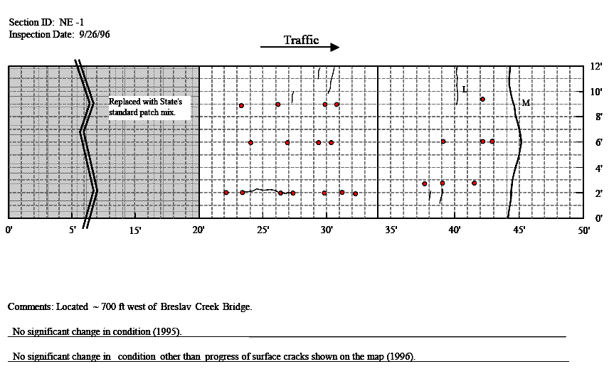
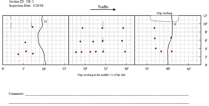
Figure 42. Graph. Distress maps for patches NE-1 and NE-2 in Nebraska–1996.

Figure 43 part 1. Distress maps for patches NE-1 and NE-2 in Nebraska, 1997. The figure consists of a distress map which sHows location as length of pavement in feet on the Horizontal axis and the pavement width in feet on the vertical axis and traffic flow from left to right. The inspection date is October 8, 1997 for the Nebraska 1 section. The pavement section from 0 to 20 feet was replaced with the State’s standard pavement mix. There are six patches between 17 and 30 feet at a pavement with of 3 feet. There are three patches between 37 and 42 feet between widths of 2 and 3 feet. At a pavement width of 6 feet, there are patches at 24, 27, 29, 30, 39, 42, and 43 feet. At a pavement width of 9 feet, there are patches located at 23, 27, 30, 31, and 42 feet. There is one longitudinal crack that extends from 20 to 27.5 feet at a pavement width of 2 feet, with map cracking at the left end. There is one transverse crack located at 30 feet that extends from 10 to 12 feet. There are two one foot transverse cracks at 27 and 29 feet between pavement widths of 9 and 12 feet. There is a one foot transverse crack located at 38 feet between 1 and 2 feet. There is one low level transverse crack located at 41 feet between widths of 9 and 12 feet. There is a one foot transverse crack located at 39 feet between widths of 1 and 2 feet. There is on transverse crack located at 39 feet between 8.5 and 10 feet and another at 40.5 feet between 7.5 and 9 feet. There is one medium level transverse crack that extends completely across the pavement between 44 and 45 feet with about half of the pavement missing between tHose two locations. The comment field states that the section is located 700 west of Breslav Creek Bridge and there is an increase in map cracking since 1997. For the Nebraska 2 section, the inspection date is September 8, 1997. At pavement widths between 3 and 4 feet, there are single patches located at 4, 6, 7, 17, and 18 feet, six between 21 and25 feet, single patches at 30, 37, 38, and 40 feet. At a pavement width of 6 feet, there are patches located at 5.5, 19, 22.5, 25, 29, 37, and 40 feet. At a pavement width of 9 feet, there are patches located at 7.5, 19, 25, 29.5, and 37 feet. There is on medium level transverse crack that extends completely across the pavement at 10 feet and another at 40 feet, with both cracks sHowing loss of pavement around the crack. Between 2 and 7 feet, between pavement widths of 9 and 12 feet, there are 11 cracks of lengths ranging from 1 to 4 feet and extending in various directions. Between 0 and 2 feet, there are three cracks between pavement widths of 1 and 2 feet and extending in various directions. Between 3 and 7.5 feet at pavement widths between 2 and 3 feet, there are two transverse cracks of about 2 feet in length. Between 15 and 19 feet, at a pavement width of 3 feet, there are two transverse cracks of about 2 feet in length each. At 24 feet, there are four transverse cracks between pavement widths of 0 and 1 feet, 3 and 4 feet, 5 and 7 feet, and 9 and 11 feet. There is an area of map cracking between 36 and 43 feet between pavement widths of 10 and 12 feet. There is a comment stating that map cracking is in the middle third of the slab.

Comments: Located – 700 ft west of Breslav Creek Bridge.

No significant change in condition (1995).

No significant change in condition other than progress of surface cracks sHown on the map (1996).

Increase in map cracking (1997).

figure 43 part 2. The description for these Distress Maps is the same as for part 1 of Figure 43

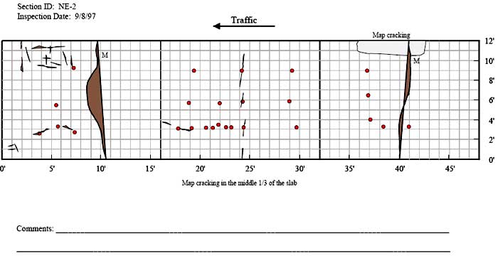
Figure 43. Graph. Distress maps for patches NE-1 and NE-2 in Nebraska–1997.

Figure 44. Distress maps for patches NE-1 and NE-2 in Nebraska, 1998. The figure consists of a distress map which sHows location as length of pavement in feet on the Horizontal axis and the pavement width in feet on the vertical axis and traffic flow from left to right. The inspection date is October 13, 1998 for the Nebraska 1 section. The pavement section from 0 to 20 feet was replaced with the State’s standard pavement mix. There are six patches between 17 and 30 feet at a pavement with of 3 feet. There are three patches between 37 and 42 feet between widths of 2 and 3 feet. At a pavement width of 6 feet, there are patches at 24, 27, 29, 30, 39, 42, and 43 feet. At a pavement width of 9 feet, there are patches located at 23, 27, 30, 31, and 42 feet. There is one longitudinal crack that extends from 20 to 27.5 feet at a pavement width of 2 feet, with map cracking at the left end. There is one transverse crack located at 30 feet that extends from 10 to 12 feet. There are two one foot transverse cracks at 27 and 29 feet between pavement widths of 9 and 12 feet. There is a one foot transverse crack located at 38 feet between 1 and 2 feet. There is one low level transverse crack located at 41 feet between widths of 9 and 12 feet. There is a one foot transverse crack located at 39 feet between widths of 1 and 2 feet. There is on transverse crack located at 39 feet between 8.5 and 10 feet and another at 40.5 feet between 7.5 and 9 feet. There are four new transverse cracks between 37 and 39 feet, each between, 1 and 2 feet in length, between pavement widths of 1 and 6 feet. There is one medium level transverse crack that extends completely across the pavement between 44 and 45 feet. There are two new cracks located at 29 feet between a width of 11 and 12 feet. The comment field states that the section is located 700 west of Breslav Creek Bridge and there is significant increase in map cracking since 1998. For the Nebraska 2 section, the inspection date is October 13, 1998. At pavement widths between 3 and 4 feet, there are single patches located at 4, 6, 7, 17, and 18 feet, six between 21 and 25 feet, single patches at 30, 37, 38, and 40 feet. At a pavement width of 6 feet, there are patches located at 5.5, 19, 22.5, 25, 29, 37, and 40 feet. At a pavement width of 9 feet, there are patches located at 7.5, 19, 25, 29.5, and 37 feet. There is on medium level transverse crack that extends completely across the pavement at 10 feet and another at 40 feet. Between 2 and 7 feet, between pavement widths of 8 and 12 feet, there are 14 cracks of lengths ranging from 1 to 4 feet and extending in various directions. Between 0 and 2 feet, there are three cracks between pavement widths of 1 and 2 feet and extending in various directions. Between 3 and 7.5 feet at pavement widths between 2 and 3 feet, there are two transverse cracks of about 2 feet in length. Between 6 and 9 feet, there is one 2 foot transverse crack and one 3 foot longitudinal crack between pavement widths of 6 and 7 feet. Between 15 and 19 feet, at a pavement width of 3 feet, there are two transverse cracks of about 2 feet in length each. At 24 feet, there are four transverse cracks between pavement widths of 0 and 1 feet, 3 and 4 feet, 5 and 7 feet, and 9 and 11 feet. There is an area of map cracking between 36 and 43 feet between pavement widths of 10 and 12 feet. There is a comment stating that map cracking is in the middle third of the slab.

figure 44 part 2. The description for this Distress map is the same as that for part 1

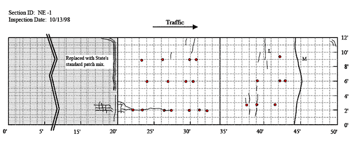
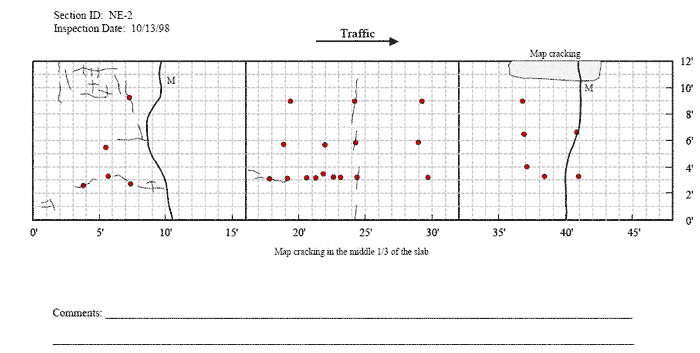
Figure 44. Graph. Distress maps for patches NE-1 and NE-2 in Nebraska–1998.


Federal Highway Administration | 1200 New Jersey Avenue, SE | Washington, DC 20590 | 202-366-4000
Turner-Fairbank Highway Research Center | 6300 Georgetown Pike | McLean, VA | 22101