U.S. Department of Transportation
Federal Highway Administration
1200 New Jersey Avenue, SE
Washington, DC 20590
202-366-4000
Federal Highway Administration Research and Technology
Coordinating, Developing, and Delivering Highway Transportation Innovations
 |
| This report is an archived publication and may contain dated technical, contact, and link information |
|
Publication Number: FHWA-HRT-05-068 Date: October 2005 |
The most common equipment currently used to measure smoothness of new PCC pavements for construction acceptance is the profilograph.(2) The trace obtained from the profilograph is used to compute the Profile Index (PI) of the pavement.
For pavement management purposes, SHAs use inertial profilers to collect profile data on their pavement network and then compute the International Roughness Index (IRI) using this data. Currently, many SHAs use PI to judge the smoothness of pavements for construction acceptance and then use IRI to monitor the performance of the pavement.
Recently, several SHAs have started using inertial profilers to measure the smoothness of new PCC pavements. Inertial profilers are capable of recording profile features of the road that affect ride quality. The collected data are then used to compute IRI to judge the smoothness of the pavement for construction acceptance. (A profilograph simulation can also be carried out on the inertial profiler data to obtain a profilograph trace. This trace can then be used to compute the PI of the roadway.) Several SHAs that have been using the PI for construction acceptance have converted to using IRI, and other SHAs currently using profilographs are looking into the possibility of adopting IRI as the construction acceptance index for smoothness.
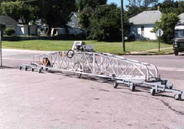
The most common profilograph used today is the truss-type California profilograph (see figure 1). The profilograph consists of a rigid frame with a system of support wheels at each end and a center wheel for profile measurement. The distance between the centers of the supporting wheel systems in the profilograph is 7.6 meters (m) (25 feet (ft)). The support wheels establish a datum from which the deviations of the center wheel can be evaluated. The center wheel is linked to a strip chart recorder or a computer that records the movement of the center wheel from the established datum. The profilograph is pushed along the pavement, and 3 to 5 kilometers (km) (1.9 to 3.1 miles (mi)) of the pavement can be measured in 1 hour.
Most profilographs in use today are computerized to electronically record the data. Mechanical profilographs used before computerized profilographs recorded data on a strip chart recorder. Computerized profilographs use a computer program to compute the PI of the pavement. The strip chart recorder output from mechanical profilographs is evaluated either manually or electronically. Using a manual method, a technician evaluates the profilograph output to determine the PI. Using an electronic method, the output of the strip chart recorder is scanned, and a computer program performs the data reduction.
Figure 1. Truss-type California profilograph.
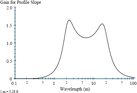
There have been questions about the effectiveness of profilographs in measuring wavelengths related to ride quality. Kulakowski and Wambold reported that profilographs vary in how they respond to wavelengths present on roadways.(3) According to the authors, profilographs correctly measure some wavelengths, amplify some wavelengths, and hardly measure some wavelengths. Figure 2 shows the actual and desired frequency response of a 12-wheel California profilograph. As shown in this figure, the California profilograph gives a poor measurement for wavelengths between 3 to 4.6 m (10 to 15 ft), and amplifies the response for wavelengths between the 6.1- to 12.2-m (20- to 40-ft) range by as much as two times.
Because profilographs are known to amplify and attenuate the true pavement surface profile, concerns have been raised about the suitability of using profilograph data to judge the smoothness of new pavements for construction acceptance.
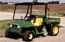
Inertial profilers are able to measure elevation features of the roadway that affect ride quality. The first high-speed inertial profiler was developed by Spangler and Kelley.(4) Most SHAs use high-speed profilers to collect roughness data on their highway networks. Figure 3 shows a photograph of a high-speed profiler. Currently, new PCC pavements usually are profiled immediately after they are paved; therefore, van-based high-speed profilers cannot be used to collect profile data on these pavements, because the pavement is not yet strong enough to support the weight of a van. Lightweight inertial profilers (see figure 4) based on a utility vehicle can be used to profile new PCC pavements several hours after the pavement is placed. The profiling system in a lightweight profiler is similar to the profiling system in a high-speed inertial profiler.
Figure 2. Desired and actual frequency response of 12-wheel California style profilograph.(3)
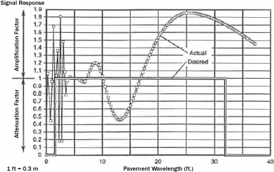
Figure 3. High-speed profiler.
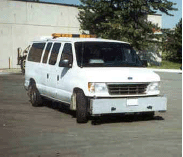
Figure 4. Lightweight profiler.
A schematic diagram of a high-speed inertial profiler is shown in figure 5. The principal components of an inertial profiler are the height sensor(s), accelerometer(s), a distance measuring system, and computer software and hardware.
Figure 5. Components of an inertial profiler.(5)
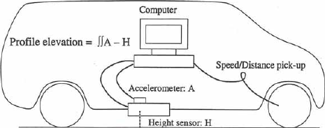
The height sensor records the height to the pavement surface from the vehicle. The accelerometer located on top of the height sensor records the vertical acceleration of the vehicle. The acceleration is mathematically converted to vertical displacement. The distance measuring system keeps track of the distance with respect to a reference starting point. Data from the height sensor and the accelerometer are combined to compute the profile of the pavement, and the computed profile is recorded in the computer at a specified distance interval. Laser sensors are the most common height sensors currently used in profilers.
Three smoothness indices currently in use are the PI, IRI, and ride number (RN). The trace obtained from the profilograph is used to obtain PI (PI can be simulated from measurements obtained from an inertial profiler). The data obtained from an inertial profiler must be used to compute IRI and RN. A description of these three indices is presented in this section.
There is no universal standard for reducing profilograph traces. Each State agency has its own standardized procedures. Therefore, comparisons of the PI values between States may not be meaningful. California has had extensive experience with the use of profilographs and uses California Test Method 526 for reducing profilograph traces.(6) The general procedures used in reducing the profilograph trace to obtain PI are described in this section. A computer program performs these procedures for computerized profilographs and when scanned data from mechanical profilographs are analyzed.
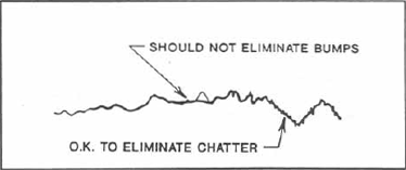
The purpose of outlining the trace is to average out spikes and minor deviations caused by rocks, texture, dirt, or transverse grooving. Outlining consists of drawing a new profile line through the midpoint of the spikes of the field trace as shown in figure 6. It is assumed that this was an enhancement adopted by many agencies to reduce variability and expedite trace reduction.(7) Outlining the trace is currently not included in the California Test Method 526.(6)
Figure 6. Example of an outlined trace.(7)
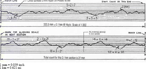
The next process in trace reduction is to place the blanking band on the profile trace. The procedure for positioning the blanking band is described in California Test Method 526.(7) The scale used to evaluate the profilograph trace is made of plastic; it is 40 millimeters (mm) (1.6 inches) wide and 333.3 mm (13.1 inches) long, representing a pavement length of 0.1 km (0.06 mi). At the center of the scale, there is an opaque band 5 mm (0.2 inches) wide, which extends the full length of the scale. In the horizontal direction, the scale represents a scale of 1:300; the scale is a true scale (1:1) in the vertical direction. Parallel to the opaque band on both sides are five scribed lines that are at 2-mm (0.08-inch) intervals. The blanking band is placed over the profile trace so that the 5-mm (0.2-inch)-wide center band blanks out as much of the profile as possible. When this is done, the deviations above and below the opaque band will be approximately balanced. The common blanking bands in use today are the 5-mm (0.2-inch) and zero blanking bands. The zero blanking band just has a reference line. The length of the plastic scale can vary according to the length of the pavement used to evaluate the PI. The scale dimensions described previously are applicable when the evaluated length of the pavement is 0.1 km (0.06 mi). Some highway agencies are using a pavement length of 161 m (528 ft) to evaluate the PI. In these cases, the length of the scale will be different from the value described previously.
The California Test Method 526 describes the procedure for computing the PI.(7) Starting at the right end of the scale, the heights of the scallops appearing both above and below the blanking band are measured to the nearest 1 mm (0.04 inch) and totaled. The excursions are evaluated against the five parallel lines scribed on both sides of the blanking band. However, unless the feature projects 0.6 mm (0.02 inch) or more and extend longitudinally for 0.6 m (2 ft) or more on the pavement (2 mm (0.08 inch) on the profilograph trace), they are not counted. The sum of the recorded heights within a given segment will be the PI for that segment. The PI is expressed in terms of millimeters per kilometer (mm/km) or inches per mile (inches/mi). Figure 7 shows an example of a profilograph trace and how the PI is computed.
Figure 7. Determining PI from a profilograph trace.(6)
IRI was developed in a 1982 study performed to establish a correlation and calibration standard for roughness measurements.(8) IRI is defined as a property of the true profile, and therefore it can be computed from the profile measured with any valid profiler. IRI was mainly developed to match the response of passenger cars, but subsequent research has shown good correlation with light trucks and heavy trucks. Specifically, IRI is highly correlated to three vehicle response variables that are of interest: road meter response (for historical continuity), vertical passenger acceleration (for ride quality), and tire load (for vehicle controllability and safety).
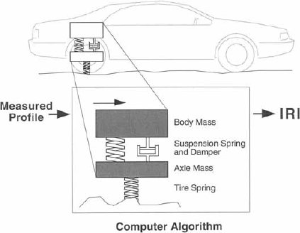
The computation of IRI is based on a mathematical model called a quarter car model. The quarter car is simulated on the measured profile to calculate the suspension deflection. This simulation is performed for a speed of 80 kilometers per hour (km/h) (50 miles per hour (mi/h)). The mathematical simulation is carried out by a computer program shown schematically in figure 8. The quarter car model used in the IRI algorithm is just what its name implies: a model of one corner (a quarter) of a car. As shown in figure 8, the quarter car is modeled as one tire that is represented with a vertical spring, the mass of the axle supported by the tire, a suspension spring and damper, and the mass of the body supported by the suspension for that tire. The absolute values of the suspension motions obtained from the simulation are summed and then divided by the simulation length to obtain the average suspension motion over the simulated length. The value computed is the IRI, which has units of slope, with the most common units being inches per mile or meters per kilometer.
Figure 8. Illustration of computer algorithm used to compute IRI.(5)
A computer program is used to calculate IRI from profile data. The American Society for Testing and Materials (ASTM) Standard E1926, "Standard Practice for Computing International Roughness Index of Roads from Longitudinal Profile Measurements" presents the computer program used to compute IRI.(9) IRI is calculated for a single profile. As most profilers collect data along the two wheel paths, the IRI computation should be carried out separately for each wheel path. The average of the IRI values obtained along the two wheel paths is referred to as the mean IRI and this number is frequently used as a measure of roughness of the road.
The response of the IRI quarter car filter to different wavelengths is shown in figure 9. IRI is mostly influenced by wavelengths ranging from 1.2 to 30.5 m (4 to 100 ft). However, there is still some response for wavelengths outside this range. The IRI filter has maximum sensitivity to sinusoids with a wavelength of 2.4 m (8 ft) and 15.4 m (51 ft).
Figure 9. Response of IRI filter.(5)
The shape of slabs in a PCC pavement can vary because of curling and warping. Slab curling refers to the change in the PCC slab shape that occurs because of daily variations in temperature. Slab warping refers to the change in slab shape that occurs from moisture variations in the PCC slab, which occur over the long term. It is believed that in the early morning hours when the top of the slab is cooler than the bottom of the slab, the slab has an upward curl, where the slab joint is at a higher elevation with respect to the center of the slab. In the afternoon hours, when the top of the slab is warmer than the bottom, the slabs are believed to have a downward curl, where the center of the slab is at a higher elevation than the slab joints. However, research has shown that some pavements will not change the slab shape from an upward curl to a downward curl because of daily temperature variations.(10,11) These pavements are permanently in an upward curled position, and although the amount of curling will change due to temperature variations, the slabs will not attain a flat position or a downward curl.
Curling or warping present in PCC slabs will affect IRI. Higher amounts of curling or warping will cause IRI to increase. Most jointed PCC pavements have a joint spacing between 4.6 and 6.1 m (15 and 20 ft). The presence of curling or warping in the PCC slab will cause an increase in the wavelength content at a wavelength that is equal to the joint spacing, which in turn will cause an increase in IRI.
For decades, highway engineers have been interested in obtaining the opinion of the traveling public on the roughness of roads. The Present Serviceability Index (PSI) scale from the American Association of State Highway Officials (AASHO) Road Test has been of interest to engineers since its introduction in the 1950s. PSI ranges from 0 to 5, with 5 representing a perfectly smooth road and 0 representing a road that is almost impassable. RN is a PI intended to indicate rideability on a scale similar to PSI. The longitudinal profile measurements taken with a profiler are processed using a computer program to obtain RN.
The National Cooperative Highway Research Program (NCHRP) sponsored two research projects in the 1980s that investigated the effect of road surface roughness on ride comfort.(12,13) The objective of that research was to determine how features in road profiles were linked to subjective opinion about the road from members of the public. During two studies, spaced at about a 5-year interval, mean panel ratings (MPR) were determined experimentally on a 0 to 5 scale for test sites in several States. Longitudinal profiles were obtained for the left and right wheel paths of the lanes that were rated. Profile-based analyses were developed to predict MPR. A method was developed by which power spectral density (PSD) functions were calculated for the two longitudinal profiles measured along the wheel paths and reduced to provide a summary statistic called PI. (No relationship exists between PI used in RN computations and PI obtained from the reduction of profilograph traces.) The PI values for the two profiles were then combined in a nonlinear transform to obtain an estimate of MPR. The mathematical procedure developed to calculate RN is described in NCHRP Report 275.(12) Software for computing RN with this method was never developed for general use.
In 1995, some of the data from these two NCHRP projects and a panel study conducted in Minnesota were analyzed by the University of Michigan Transportation Research Institute (UMTRI) for a pooled-fund study initiated by FHWA.(14) The objective of this analysis was to develop and test a practical mathematical process for obtaining RN. The profile data in the original NCHRP research were obtained from several instruments. Most measurements were made with a K.J. Law profiler owned by the Ohio Department of Transportation (DOT) and were thought to be accurate. A few other test sites were profiled with instruments whose validity has been questioned. The new analysis was limited to 138 test sites that had been profiled with the Ohio system and the data from the Minnesota study. Based on analysis of this data, a new profile analysis method to compute RN was developed.(14) This procedure predicts MPR slightly better than previously published algorithms. The software was tested on profiles obtained from different systems on the same sites, and similar values of RN were obtained.
RN uses a scale from 0 to 5. This scale was selected because it is familiar to the highway community. RN is a nonlinear transform of a statistic called PI, which is computed from profile data. PI ranges from 0 (a perfectly smooth profile) to a positive value proportional to roughness. PI is transformed to a scale that goes from 5 (perfectly smooth) to 0 (the maximum possible roughness).
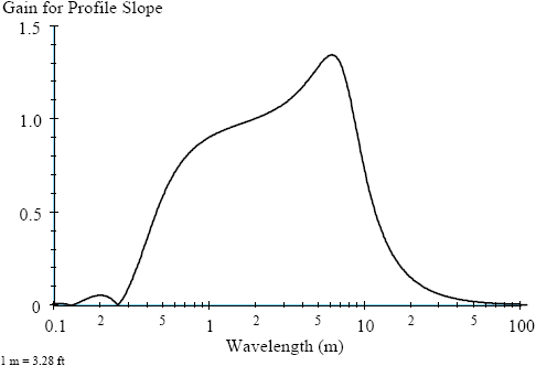
Figure 10 shows the sensitivity of PI for a slope sinusoid. When a sinusoid is given as an input, the PI filter produces a sinusoid as the output. The amplitude of the output sinusoid is the amplitude of the input, multiplied by the gain shown in the figure. The maximum sensitivity occurs for a wavelength of about 6.1 m (20 ft). The content of a road profile that affects RN is different from the content that affects IRI. IRI has high sensitivity to sinusoids with a wavelength of 2.4 to 15.4 m (8 to 51 ft). Figure 10 shows that RN has a low sensitivity to a wavelength of 15.4 m (51 ft) and even lower sensitivity for longer wavelengths. IRI is primarily influenced by wavelengths between 1.2 and 30.5 m (4 and 100 ft). RN is primarily influenced by wavelengths between 0.5 and 11 m (1.6 and 36 ft). IRI and RN will not always correlate the same way and do not have the same meaning. Thus, they each provide unique information about the roughness of the road.
Figure 10. Sensitivity of PI for a slope sinusoid.(5)
The ASTM Standard E 1489, "Standard Practice for Computing Ride Number from Longitudinal Profile Measurements Made by an Inertial Profile Measuring Device," presents the computer program that should be used to compute RN.(9)
Rizzo performed a survey in 2000 that found the PI obtained from profilograph measurements was the most common method used in the United States to measure the smoothness of new PCC pavements for construction acceptance.(2) The most common blanking band in use was 5 mm (0.2 inch), but some SHAs were using a 2.5-mm (0.1-inch) or a zero blanking band. The survey also found that some SHAs specify pay incentives for obtaining a smoothness value that is better than the required value while others do not. The full pay PI range varied according to the blanking band that was specified in the smoothness specification. Even for a specific blanking band, the full pay PI ranges were different among States. For example, the full pay PI range for a zero blanking band for two highway agencies varied from between 236 and 315 mm/km (15 to 20 inches/mi) and 394 and 552 mm/km (25 to 35 inches/mi).
Highway agencies continually are using their experiences on paving projects to refine their smoothness specification. Hancock and Hossain presented an overview of how the PCC smoothness specification in Kansas evolved over the years.(15) The first PCC pavement with a smoothness specification was built in Kansas in 1985, and the Kansas DOT (KDOT) adopted the first standard specification in 1990. This specification was based on reducing the output from a 7.6-m (25-ft) California profilograph using a 5-mm (0.2-inch) blanking band. In 1990, KDOT noted a high frequency vibration on a PCC reconstruction project on I-70. Careful review of the profilograph trace revealed a sine-wave oscillation of about 2.4-m (7.9-ft) spacing with a 5.1-mm (0.2-inch) amplitude. However, most of the surface deviations were covered up by the 5-mm (0.2-inch) blanking bandwidth during the trace reduction that resulted in an acceptable PI. A project on Interstate (I)-470 indicated oscillation waves that were spaced at about 9.1 m (30 ft) with an amplitude of 5 mm (0.2 inch), which were again covered by the 5-mm (0.2-inch) blanking band.
These results prompted KDOT to study the effects of blanking bandwidth on trace reduction. Based on this review, KDOT adopted a zero blanking bandwidth. A zero blanking band is merely a reference line placed approximately at the center of the trace. The change in the blanking bandwidth resulted in a new PCC smoothness specification that was adopted in 1992. Further refinements in the smoothness specification occurred between 1992 and 1996. Before 1996, the smoothness specification was based on percentage of bid item. The smoothness specification was designed this way because concrete pavements were usually bid as unit item per square meter. In 1996, KDOT adopted a dollar value incentive scheme where a specific dollar amount was assigned as incentive for each 0.16 km (0.1 mi) section per lane depending on the obtained PI.
As indicated previously, most highway agencies use PI to judge the smoothness of a pavement for construction acceptance. Thereafter, they use a roughness statistic such as IRI to monitor the roughness of their pavement network. With these different profile indices, it is not possible to relate the roughness of the pavement at some point in time with its as-constructed smoothness. Currently, some SHAs are moving toward adopting a consistent measure of pavement smoothness that can be used throughout the life cycle of a roadway. This measure would involve using the same index to measure the pavement smoothness for construction acceptance as well as to monitor the pavement for pavement management purposes. Several SHAs have adopted IRI as this index. Using the same smoothness index to measure the smoothness for construction acceptance and thereafter to monitor the roughness over time will enable highway agencies to monitor the performance of a pavement from cradle to grave.

