
The objective of the research study is to determine pollutant concentrations and the variation of pollutant concentrations as a function of distance from the highway (Figure 11). Additional important considerations of the study includes establishing relationships between pollutant concentrations as related to highway traffic characteristics including traffic count, vehicle types and speeds, and meteorological conditions such as wind speed and wind direction. This study provided detailed concentration data and distributions of motor vehicle emitted pollutants including regulated gases, air toxics, and particulate matter.4
FHWA's "detailed monitoring protocol" outlines a uniform approach to conduct all studies for evaluating mobile source contributions to air toxic compounds and PM2.5 and their dispersion patterns2. A more detailed examination of the monitoring protocol indicates that for each city, continuous monitoring and integrated sample collection was required at four monitoring sites (Figure 11). In addition, wind speed and wind direction were required at each site. Moreover, monitoring for the complete suite of meteorological parameters was required at the monitoring station positioned 50 to 150 m from the roadway (100 meter downwind). Table 1 summarizes the measurements taken at each monitoring site and Table 5 summarizes measurement parameters, sampling approach, and instruments.
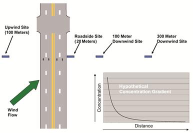
Figure 11. Illustration of Monitoring Site Locations.
Table 5. Summary of Protocol Measurement Parameters, Sampling Approach and Instruments.
Measurement Parameter |
Sampling Approach |
Instrument Data |
||||
|---|---|---|---|---|---|---|
Make/Model |
Accuracy |
Precision |
Detection Limit |
Sample Type and Frequency |
||
Carbon Monoxide (CO) |
nondispersive infrared |
EC 9830T |
± 5% 0-1000ppb |
0.5% of reading |
25 ppb |
Continuous (5 minute) |
Oxides of nitrogen (NOx) |
chemiluminescence |
EC 9841B |
< 1% |
0.5 ppb |
0.5 ppb |
|
Black Carbon (BC) |
Aethalometer |
Magee - Aethalometer, Models AE16 and AE20 |
1:1 comparison w/ EC on filters |
Repeatability: 1 part in 10,000 |
0.1 μg/m3 w 1 min res. |
|
PM2.5 |
PM2.5 FRM method |
FRM BGI PQ200 |
24-hour integrated 1-in-12 day schedule 1 sample each day at each road-side location |
|||
PM2.5 |
TEOM |
Thermo TEOM - 1405DF |
±0.75% |
±2.0 μg/m3 (1-hour ave), ±1.0 μg/m3 (24-hour ave) |
0.1 μg/m3 |
Continuous (5 minute) |
PM10 |
||||||
PM Coarse |
||||||
Acetaldehyde |
USEPA Method TO-11A |
Atec 2200 Cartridge Sampler |
± 2 % |
± 2 % |
N/A |
1-hour integrated 1-in-12 day schedule 9 samples each day at each road-side location |
Formaldehyde |
||||||
Acrolein |
USEPA Method TO-15 |
Entech 1800 Canister Sampler |
± 2 % |
± 2 % |
N/A |
|
Benzene |
||||||
1,3-Butadiene |
||||||
Wind Speed |
sonic anemometer |
RM Young Model 81000 |
±0.05 m/s |
std. dev. 0.05 m/s at 12 m/s |
0.01 m/s |
Continuous (5 minute) |
Wind Direction |
± 5° |
± 10° |
0.1° |
|||
Air Temperature |
temperature probe |
Vaisala HMP45D Vaisala HMP45A |
±0.2°C at 20° C |
0.1 ° C |
0.1 ° C |
|
% Relative Humidity |
relative humidity sensor |
±2%RH from 0…90% RH) |
1% RH |
1% RH |
||
Rain Gauge |
rain bucket |
Ecotech Rain Gauge |
+/- 5% at 25-50 mm/hour |
± 1mm |
± 1mm |
|
Solar Radiation |
solar radiation |
MetOne 394 Pyranometer |
±5% from 0…2800 watts meter2 |
±1% constancy from -20°C to +40°C |
9 mV/kwatt meter-2, approx |
|
Sound |
microphone |
Extech 407764 |
±1.5dB (under reference conditions) |
0.1dB |
0.1dB |
|
Video |
video |
Axix 223M Vivotek SD7151 |
N/A |
Continuous (15 minutes) |
||
Vehicle Count |
radar |
Radar (Wavetronix) |
||||
Vehicle Speed |
||||||
Vehicle Type |
||||||
1. Accuracy and precision in terms of ultrafine particle concentration is difficult to determine in the field due the lack of particle concentration standards. However, particle counters are routinely verified in the field for accuracy in flow rate. Precision was estimated in this study by collocating UFP samplers prior to use of instruments in the field.
Enhancements to the study protocol included SO2 monitors at located at Site 2 (100 meter downwind) and Site 4 (100 meter upwind). Video was also used to validate traffic count information.
The site selection process resulted in the selection of a location along I-96, approximately 800 meters (m) east of Telegraph Road (US 24) in the vicinity of Eliza Howell Park in Detroit, Michigan3. Three of the four monitoring stations were placed approximately 10 m, 100 m and 300 m downwind of I-96. The fourth monitoring station was located approximately 100 m upwind of I-96. At this location, I-96 has an east-west orientation. Prevailing winds at this location are generally west and southwest. This assessment was based on meteorological data from the National Climatic Data Center for the Detroit-Wayne County International Airport.
This site was considered the optimal site of all the candidate monitoring sites3. This site has high AADT (165,300 AADT for 2006), no noise walls, meteorological and traffic data availability, manageable site logistics including ROW access, and favorable wind direction3. This location is shown in Figure 1.

