
This appendix presents profiles of freight transportation systems and activity levels in the six selected regions. The profile of each region begins with some general socio-economic statistics and an overview of the economic base that drives much of the freight activity in the region. Each profile then discusses the four major freight modes - trucking, rail, marine, and air - providing a snapshot of the freight system and current freight activity, including an identification of major freight facilities and analysis of commodity flow data by mode. These freight profiles help to explain some of the regional differences in freight transportation emissions, as discussed in Section 3.
The Southern California Association of Governments is the metropolitan planning organization (MPO) for the Los Angeles metropolitan area. The region includes the five counties of Los Angeles, Orange, Riverside, San Bernardino, and Ventura.71 The 2002 population estimate for the five-county Los Angeles region is 17.0 million, an increase of 17 percent since 1990.72 Total employment in the region is 9.4 million.73 The Los Angeles region is designated as an air quality nonattainment area for ozone (1-hour and 8-hour standard), PM-10, and CO.
The Los Angeles region has a large and diverse economic base, driven by large manufacturing, trade, and transportation sectors.74 The region has a particularly high concentration of wholesale trade employment, as well as high concentrations of manufacturing and transportation & warehousing employment. Nearly 60,000 are employed in the truck transportation sub-sector alone. Within the manufacturing sector, the Los Angeles region has a very high concentration of employment in apparel manufacturing, particularly in Los Angeles County, and in related industries such as textile product mills and leather product manufacturing. The region is a major center for computer and electronics manufacturing, with more than 124,000 employees in this sub-sector. Other manufacturing industries concentrated in the region include furniture-making and fabricated metal products. The region has relatively low concentrations of many traditional heavy industries such as machinery, primary metals manufacturing, and chemicals manufacturing.
Table C-1 shows commodity flows into and out of the five-county Los Angeles region in 2003 by mode.75 Trucking carries 64 percent of interregional freight tonnage, marine vessels carry 21 percent, and railroads carry 14 percent. Among the six study regions, the Los Angeles region is second to Houston in total intercity freight tonnage and tied with Chicago for the greatest volume of intercity truck freight.
Table C-1: Commodity Flows Into and Out of the Los Angeles Region, 2003
| Mode | Tonnage | Percent |
|---|---|---|
| Trucking |
378,995,000 |
64% |
| Railroad |
82,013,000 |
14% |
| Marine Vessel |
124,791,000 |
21% |
| Aircraft |
2,234,000 |
0.4% |
| Total |
588,033,000 |
100% |
Source: FHWA Freight Analysis Framework (trucking and rail); Bureau of Transportation Statistics, Air Carrier Statistics T-100 database (air); U.S. Army Corps of Engineers, Waterborne Commerce of the United States database (marine).
The Los Angeles area has one of the most extensive networks of highways and arterial streets in the U.S., including 903 miles of Interstates and other highways plus 2,932 miles of principal arterial roads.76 Four major Interstate highway corridors link the region to the rest of the U.S.:
Other major truck routes include Interstates 210, 710, and 215, as well as State Routes 60, 91, 55, and 57.
Table C-2 shows annual VMT in the Los Angeles region (South Coast and Ventura nonattainment areas) by vehicle type for 2002. Heavy-duty trucks (defined as truck with a gross vehicle weight rating over 8,500 lbs) account for 6 percent of the region's total VMT, including 2 percent from gasoline trucks and 4 percent from diesel trucks.
Table C-2: Los Angeles Region Annual VMT by Vehicle Type, 2002 (millions)
| Light Duty Vehicles |
Heavy-Duty Gasoline Trucks |
Heavy-Duty Diesel Trucks |
||||
|---|---|---|---|---|---|---|
| VMT |
Percent |
VMT |
Percent |
VMT |
Percent |
Total VMT |
| 122,478 |
94% |
2,525 |
2% |
5,292 |
4% |
130,295 |
Source: California Air Resources Board; data for South Coast and Ventura County Air Basins.
Both the Union Pacific (UP) and Burlington Northern Santa Fe (BNSF) railroads have extensive operations in the Los Angeles region. There are also four short-line railroads that shuttle cars and equipment in and between the marine ports and rail intermodal yards. In 2002, UP and BNSF were handling close to 60 freight trains per day along their most heavily used line segments.77 In addition to on-dock rail terminals at the ports, there are six major rail/truck intermodal transshipment yards in the region. Three inland rail yards serve primarily the ports of Los Angeles and Long Beach:
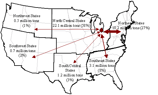
Figure C-1 illustrates domestic commodity flows by rail between Los Angeles and the rest of the U.S. Only 18 percent of the flow of rail tonnage remains within California and surrounding southwestern states. Nearly 40 percent of the flow of rail freight moves to and from the north central states, largely reflecting the flow of freight from the ports of Long Beach and Los Angeles to Chicago and other Midwestern cities. Just over a quarter of the rail tonnage moves to and from Texas and other south central states.
Figure C-1: Rail Commodity Flows To and From Los Angeles, 2003
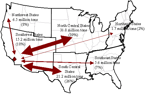
Source: FHWA, Freight Analysis Framework.
The Los Angeles area is served by the seaports of Los Angeles, Long Beach, and Hueneme. The ports of Long Beach and Los Angeles form a combined port facility commonly referred to as the San Pedro Bay ports, which presently handle 80 percent of California's and 30 percent of the nation's maritime trade shipments in value terms.79 Table C-3 shows trade tonnage at the three ports in 2001. More than 80 percent of total tonnage is foreign imports or exports.
Table C-3: Waterborne Commerce at Los Angeles Area Ports, 2001
| Port of Los Angeles | |
Port of Long Beach | |
Port of Hueneme | Total | ||||||
|---|---|---|---|---|---|---|---|---|---|---|---|
| Tons | Percent | Tons | Percent | Tons | Percent | Tons | Percent | ||||
| Foreign Imports | 30,302,000 |
59% |
37,729,000 |
56% |
956,000 |
85% |
68,987,000 |
57% |
|||
| Foreign Exports | 14,636,000 |
28% |
13,819,000 |
20% |
109,000 |
10% |
28,564,000 |
24% |
|||
| Coastwise | 5,170,000 |
10% |
15,077,000 |
22% |
64,000 |
6% |
20,311,000 |
17% |
|||
| Internal and Local | 1,257,000 |
2% |
1,004,000 |
1% |
0 |
0% |
2,261,000 |
2% |
|||
| Total | 51,365,000 |
100% |
67,629,000 |
100% |
1,129,000 |
100% |
120,123,000 |
100% |
|||
Source: U.S. Army Corps of Engineers, Waterborne Commerce of the United States database.
The Los Angeles area handles nearly twice as much air cargo tonnage as any of the other five study areas. The region has five cargo-capable commercial airports: Los Angeles International (LAX), Ontario International, Burbank, Long Beach, and John Wayne/Santa Ana. LAX ranks fifth nationally in terms of the landed weight of all-cargo aircraft.82 Table C-4 shows air freight tonnage (cargo and passenger aircraft) at the region's five airports.
| Air Cargo (tons) | |||
|---|---|---|---|
| Airport | Inbound | Outbound | Total |
| Los Angeles International (LAX) | 899,658 |
734,625 |
1,634,282 |
| Ontario International (ONT) | 240,881 |
254,298 |
495,179 |
| Burbank (BUR) | 15,037 |
22,542 |
37,580 |
| Long Beach (LGB) | 23,431 |
29,145 |
52,576 |
| John Wayne/ Santa Ana (SNA) | 1,954 |
12,380 |
14,334 |
| Total | 1,180,961 |
1,052,990 |
2,233,951 |
Source: Bureau of Transportation Statistics, Air Carrier Statistics T-100 database.
The North Central Texas Council of Governments (NCTCOG) is the MPO for the Dallas-Fort Worth metropolitan area. The region includes all of Collin, Dallas, Denton, Rockwall, and Tarrant Counties, and contiguous portions of Ellis, Johnson, Kaufman, and Parker Counties.83 Other major cities in the region include Arlington, Garland, Irving, and Plano. The 2002 population of the Dallas-Fort Worth region is estimated at 5.3 million, an increase of 37 percent since 1990.84 Total 2002 employment in this region was 3.4 million.85 The Dallas-Fort Worth region is designated as a nonattainment area for ozone (1-hour and 8-hour standard).
The regional economy of the Dallas-Fort Worth area is driven by the service sector and by trade and transportation industries.86 Wholesale trade is heavily concentrated in the region, particularly in Dallas, as is the transportation & warehousing sector. Although they are the largest two industry sectors in the region, the manufacturing and retail sector employment shares in Dallas-Fort Worth are lower than the national average. The region has high concentration of certain manufacturing sub-sectors. Computer & electronic product manufacturing is heavily concentrated in the region, particularly in Dallas. Transportation equipment manufacturing is heavily concentrated in Fort Worth. The region also has relatively high concentrations in the printing industry, beverage products, and nonmetallic mineral product manufacturing.
Table C-5 shows commodity flows into and out of the Dallas-Fort Worth region by mode. Trucking dominates intercity freight flows in Dallas-Fort Worth more than the other five study regions, carrying 87 percent of all freight tonnage into and out of the region. The Dallas-Fort Worth region has no significant waterborne freight flows.
Table C-5: Commodity Flows Into and Out of the Dallas-Fort Worth Region, 2003
| Mode | Tonnage | Percent |
|---|---|---|
| Trucking |
237,442,000 |
87% |
| Railroad |
33,454,000 |
12% |
| Marine Vessel |
0 |
0% |
| Aircraft |
840,000 |
0.3% |
| Total |
271,735,000 |
100% |
Source: FHWA Freight Analysis Framework (trucking and rail); Bureau of Transportation Statistics, Air Carrier Statistics T-100 database (air).
In the Dallas-Fort Worth area, trucking moves over a network of greater than 556 miles of Interstate and other highways and 1,026 miles of other principal arterial roads.87 Interstates linking the Dallas area to the rest of the U.S. include:
According to the 1997 Commodity Flow Survey, 65 percent of freight tonnage shipped by truck in the Dallas-Fort Worth CMSA moves less than 50 miles. This suggests that 35 percent of truck freight shipments originating in the region (on a tonnage basis) leaves the region, the highest percentage of the six study areas.
Table C-6 shows the annual VMT by vehicle type in the four-county core of the Dallas-Fort Worth region (Collin, Dallas, Denton, and Tarrant Counties). Heavy-duty trucks account for 9 percent of total VMT, 2 percent from gasoline trucks and 7 from diesel trucks.
Table C-6: Dallas-Fort Worth Area Annual VMT by Vehicle Type, 2002 (millions)
| Light Duty Vehicles |
Heavy-Duty Gasoline Trucks |
Heavy-Duty Diesel Trucks |
|
|||
|---|---|---|---|---|---|---|
| VMT |
Percent |
VMT |
Percent |
VMT |
Percent |
Total VMT |
| 43,232 |
91% |
744 |
2% |
3,279 |
7% |
47,256 |
Source: North Central Texas Council of Governments.
Three Class I railroads operate in the Dallas-Fort Worth region: UP, BNSF, and Kansas City Southern. Fort Worth is one of UP's three operations hubs in Texas, and the city is also the home to Centennial Yard, one of the railroad's largest freight classification facilities. Fort Worth is the location of Tower 55, one of the busiest railroad intersections in the United States, where several railroads share the crossing with UP.88 UP operates intermodal truck-rail facilities in Dallas and Mesquite.89
BNSF operates the Intermodal and Carload Transportation Center at the Alliance Airport near Fort Worth, one of the largest facilities of its kind in the country. Kansas City Southern provides rail service throughout the south central states and also to Mexico through its subsidiaries, including the Texas Mexican Railway (Tex Mex) and the Mexican Grupo Transportacion Ferroviaria Mexicana, S.A. de C.V. (TFM). Kansas City Southern operates an intermodal terminal in Garland, near Dallas.
Figure C-2 shows rail freight flows between Dallas-Fort Worth and six regions of the U.S. Heavy rail freight flows occur between Dallas-Fort Worth and the north central states (27 percent of total rail flows) and between Dallas-Fort Worth and the southwestern states (23 percent of total rail flows).
Figure C-2: Rail Commodity Flows To and From Dallas-Fort Worth, 2003
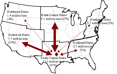
Source: FHWA, Freight Analysis Framework.
The Dallas-Fort Worth region has two major air cargo airports: Dallas/Fort Worth International (DFW) and Fort Worth Alliance. DFW is the region's largest air freight facility, handling 660,000 tons of air cargo annually. The airport ranks 11th among the nation's airports in terms of landed weight of cargo carriers. The Alliance Airport north of Fort Worth is the largest commercial/industrial airport in the country, providing airfreight service for manufacturing, warehousing, and distribution firms throughout the region. Federal Express operates from the Alliance Airport. Table C-7 shows annual inbound and outbound air freight tonnage (cargo and passenger carriers) at the two airports.
Table C-7: Dallas-Fort Worth Area Air Cargo Flows, 2003
| Air Cargo (tons) | |||
|---|---|---|---|
| Airport | Inbound | Outbound | Total |
| Dallas-Fort Worth International (DFW) | 350,570 |
308,642 |
659,213 |
| Alliance Fort Worth (ATW) | 67,176 |
75,173 |
142,350 |
| Total | 417,747 |
383,816 |
801,562 |
Source: Bureau of Transportation Statistics, Air Carrier Statistics T-100 database.
The Houston-Galveston Area Council (HGAC) is the MPO for the Houston metropolitan area. The region includes Harris County, which contains the City of Houston, and seven surrounding counties (Brazoria, Chambers, Fort Bend, Galveston, Liberty, Montgomery, and Waller). The 2002 population estimate for the eight-county Houston region is 4.9 million, an increase of 32.4 percent since 1990.90 The 2002 estimate for employment in the region was 2.9 million.91 The Houston-Galveston-Brazoria region is designated as a nonattainment area for ozone (1-hour and 8-hour standard).
Freight transportation in the Houston region is heavily influenced by the region's concentration of petrochemical industries. Houston has the highest concentration of transportation & warehousing employment among the six study areas and also a high concentration of construction and wholesale trade employment.92 The manufacturing employment share in the Houston region is lower than the national average. But the region has very high employment concentrations in petroleum products and chemicals manufacturing. This is due in part to the large number of petrochemical refineries in the southeastern portion of the Houston region and also the presence of major petrochemical company headquarters in downtown Houston. The region also has high concentrations of fabricated metal product manufacturing and machinery manufacturing. Light industries such as apparel, computer & electronics products, and food manufacturing have a relatively small presence in the region.
Table C-8 shows commodity flows into and out of the Houston region in 2003 by mode. The total commodity flow tonnage is the largest among the six study regions, primarily because of large marine freight component (39 percent of total freight flows). Because Houston area ports handle large volumes of petrochemicals and other bulk commodities, the total marine vessel freight tonnage at the Houston ports is more than the total marine tonnage in the other five study regions combined. Trucking carries approximately half of intercity freight flows, and railroads carry another 12 percent.
Table C-8: Commodity Flows Into and Out of the Houston Region, 2003
| Mode | Tonnage | Percent |
|---|---|---|
| Trucking | 340,435,000 |
49% |
| Railroad | 84,375,000 |
12% |
| Marine Vessel | 269,307,000 |
39% |
| Aircraft | 352,000 |
0.1% |
| Total | 694,468,000 |
100% |
Source: FHWA Freight Analysis Framework (trucking and rail); Bureau of Transportation Statistics, Air Carrier Statistics T-100 database (air); U.S. Army Corps of Engineers, Waterborne Commerce of the United States database (marine).
In the Houston urbanized area, trucking moves on a network of 456 miles of Interstate and other highways, plus 858 miles of other principal arterials.93 The region is traversed by I-10 (running from California to Florida) and I-45 (running from Galveston to Dallas), and U.S. 59 (running from Laredo to Shreveport). The I-610 loop encircles the region.
Table C-9 shows annual VMT in the eight-county Houston region by vehicle type and county. Three-quarters of the region's VMT occurs in Harris County. Total VMT in the region is similar to the Dallas-Fort Worth area, as is the composition of VMT by vehicle type: heavy-duty trucks make up 9 percent of total VMT, with 2 percent gasoline trucks and 7 percent diesel trucks.
Table C-9: Houston Area Annual VMT by Vehicle Type, 2002 (millions)
| Light Duty Vehicles | Heavy-Duty Gasoline Trucks | Heavy-Duty Diesel Trucks | ||||
|---|---|---|---|---|---|---|
| VMT | Percent | VMT | Percent | VMT | Percent | Total VMT |
|
40,949 |
91% |
744 |
2% |
3,141 |
7% |
44,834 |
Source: Texas Commission on Environmental Quality.
The Houston-Galveston region serves a major rail hub for the region and has five freight rail yards. The rail network in Houston is dominated by UP and BNSF, with UP rail lines transporting the majority of the tonnage on the system.94 The railroad's Settegast and Englewood railyards in Houston are major classification yards for the southern part of Texas and serve the petrochemical industry along the Texas Gulf Coast.95 UP also has an intermodal facility at the Port of Houston. BNSF has two intermodal facilities in the Houston area, one near Hobby airport and another at the Port of Houston. BNSF also serves the ports of Galveston and Texas City.
Figure C-3: Rail Commodity Flows To and From Houston, 2003
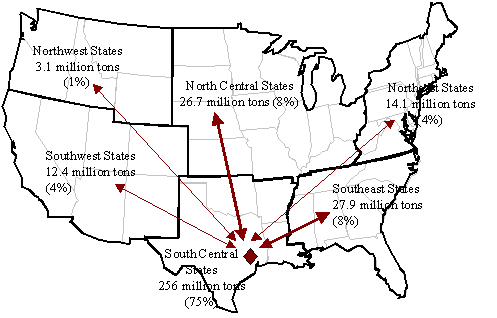
Source: FHWA, Freight Analysis Framework.
The Houston region is served by the Port of Houston, the Port of Texas City, and two smaller ports at Freeport and Galveston. Crude oil and chemical products, which are handled in large quantities at the ports in the region, are frequently processed at or in close proximity to the ports. The resulting product is then shipped out again or transported via oil pipeline to destinations such as Oklahoma. In 2002, the Port of Houston ranked 11th among U.S. containership ports, handling 1.2 million TEUs, and ranked second in the nation in terms of tonnage.97 The Port of Texas City is a privately owned, for-profit port that almost exclusively handles bulk liquid products, such as chemical and crude oil products. Table C-10 shows annual marine freight tonnage at the region's four ports. Nearly two-thirds of total tonnage is foreign imports or exports.
Table C-10: Waterborne Commerce at Houston Area Ports, 2001
| Port of Houston | Port of Texas City | Port of Galveston | Port of Freeport | Total | ||||||||||
|---|---|---|---|---|---|---|---|---|---|---|---|---|---|---|
| Tons | % | Tons | % | Tons | % | Tons | % | Tons | % | |||||
| Foreign Imports | 84,877,000 | 46% | 40,304,000 | 65% | 1,360,000 | 12% | 22,646,000 | 75% | 126,541,000 | 49% | ||||
| Foreign Exports | 34,874,000 | 19% | 3,827,000 | 6% | 4,822,000 | 43% | 2,247,000 | 7% | 43,523,000 | 17% | ||||
| Coastwise | 11,531,000 | 6% | 5,853,000 | 9% | 2,249,000 | 20% | 605,000 | 2% | 19,633,000 | 8% | ||||
| Internal and Local | 52,929,000 | 29% | 12,288,000 | 20% | 2,843,000 | 25% | 4,646,000 | 15% | 68,060,000 | 26% | ||||
| Total | 184,211,000 | 100% | 62,272,000 | 100% | 11,274,000 | 100% | 30,144,000 | 100% | 257,757,000 | 100% | ||||
Source: U.S. Army Corps of Engineers, Waterborne Commerce of the United States database.
The Houston-Galveston region has three major airports: George Bush Intercontinental Airport/Houston (IAH), William P. Hobby Airport (HOU), and Ellington Field (EFD). IAH handles the vast majority of air cargo for the Houston Airport System - 336,000 tons in 2003, as shown in Table C-11. IAH ranks 30th among the nation's cargo-service airports in terms of landed weight.
Table C-11: Houston Area Air Cargo Flows, 2003
| Air Cargo (tons) | |||
|---|---|---|---|
| Airport | Inbound | Outbound | Total |
| George W. Bush International (IAH) | 172,651 |
163,729 |
336,380 |
| William P. Hobby Airport (HOU) | 7,041 |
8,121 |
15,162 |
| Total | 179,692 |
171,850 |
351,542 |
Source: Bureau of Transportation Statistics, Air Carrier Statistics T-100 database.
The Chicago metropolitan area is the nation's third most populous area. The Chicago Area Transportation Study (CATS) is the MPO for the region, covering Cook, Dupage, Kane, Lake, McHenry, and Will counties and a portion of Kendall County, all in Illinois. In 2002, the population of the seven-county Chicago area was 8.3 million, a 14 percent increase since 1990.98 Total employment in the region is approximately 5.0 million.99 The Chicago region is designated nonattainment for ozone (1-hour and 8-hour standard).
The Chicago region has a large and diverse economy, anchored by service industries, manufacturing, trade, and transportation. The region has a relatively high concentration of wholesale trade employment and transportation & warehousing employment.100 Chicago has traditionally been a center for food processing (especially bakeries, slaughterhouses, and sugar product manufacturing), and food continues to be a major manufacturing sub-sector in the region, particularly in Cook County. The region has a high concentration of employment in fabricated metal product manufacturing. Printing is also intensive in the region, as is paper manufacturing. Finally, the Chicago region has a large concentration of electrical equipment & appliance manufacturing establishments.
Chicago is a major freight crossroads. Two transnational Interstates and all six major North American Class I railroads meet in the region. Chicago also boasts two major airports, a seaport on Lake Michigan, and canal access to the Mississippi River. Table C-12 shows domestic commodity flows into and out of the seven-county Chicago region by mode. Trucking carries 60 percent of these flows, and rail carries another 36 percent. Rail freight flows in the Chicago region are more than double the rail freight in any of the other five study regions.
Table C-12: Commodity Flows Into and Out of the Chicago Region, 2003
| Mode | Tonnage | Percent |
|---|---|---|
| Trucking | 379,532,000 |
60% |
| Railroad | 223,837,000 |
36% |
| Marine Vessel | 22,924,000 |
4% |
| Aircraft | 1,155,000 |
0.2% |
| Total | 627,448,000 |
100% |
Source: FHWA Freight Analysis Framework (trucking and rail); Bureau of Transportation Statistics, Air Carrier Statistics T-100 database (air); U.S. Army Corps of Engineers, Waterborne Commerce of the United States database (marine).
Trucking moves in the Chicago region on a network of 478 miles of Interstate and other highways plus 1,608 miles of other principle arterials.101 Interstates I-80, I-90, and I-94 connect Chicago to cities to the east, north, and west; Interstates I-55, I-57, and I-65 connect Chicago to cities to the south.
Table C-13 shows annual on-road VMT by vehicle type in the Chicago region (that portion of the ozone nonattainment area contained in Illinois). Eleven percent of VMT results from heavy-duty trucks, 3 percent from gasoline trucks and 8 percent from diesel trucks.
Table C-13: Chicago Area Annual VMT by Vehicle Type, 2002 (millions)
| Light Duty Vehicles | Heavy-Duty Gasoline Trucks | Heavy-Duty Diesel Trucks | ||||
|---|---|---|---|---|---|---|
| VMT | Percent | VMT | Percent | VMT | Percent | Total VMT |
| 51,452 |
89% |
1,893 |
3% |
4,532 |
8% |
57,876 |
Source: Illinois Environmental Protection Agency.
Chicago is the only city where all six major U.S. and Canadian Class I railroads come together to interchange freight. This includes the two major western U.S. railroads, BNSF and UP, the two major eastern U.S. railroads, CSX and Norfolk Southern, and the two major Canadian railroads, Canadian National (CN) and Canadian Pacific (CP). At least six other private railroads operate in the Chicago region, although the vast majority of the region's rail infrastructure is owned and maintained by the Class I carriers.
It has been estimated that Chicago-area railroads operate 1,200 daily trains and generate more than 3,200 daily truck trips to transfer cargo from yard to yard.102 Freight railroads in Chicago own 74 marshalling yards, including 17 for rail-truck intermodal traffic.
Figure C-4 illustrates domestic commodity flows by rail between Chicago and the rest of the U.S. Due to its position as the nation's most important rail crossroads, major rail flows move between Chicago and all regions of the U.S. Nearly one-quarter of Chicago's rail tonnage moves to and from the northwest states. This includes large volumes of freight imported from Asia through the ports of Seattle and Portland.
Figure C-4: Rail Commodity Flows To and From Chicago, 2003
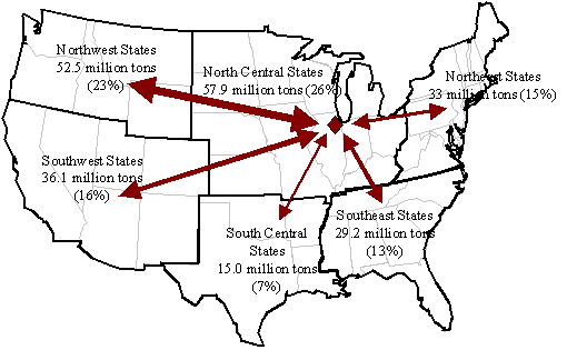
Source: FHWA, Freight Analysis Framework.
In June 2003, the city of Chicago, the state of Illinois, and the six Class I railroads announced a plan to significantly improve railroad infrastructure in the Chicago area. The plan, known as the Chicago Region Environmental and Transportation Efficiency (CREATE) project, calls for more than $1.5 billion in infrastructure improvements throughout the region. The plan includes creation of five rail corridors, 25 new grade separations, and the opening for commercial development of a key corridor in downtown Chicago.
Positioned on Lake Michigan, Chicago is a major port in the north central states, although its total waterborne freight tonnage is significantly less than the major seaport regions like Houston and Los Angeles. From Chicago, deep-draft commercial ships can reach the Atlantic Ocean through the St. Lawrence Seaway, and barge traffic can reach the Gulf of Mexico through the Illinois and Mississippi Rivers. In 2002, the Port of Chicago ranked 36th among U.S. ports in terms of tonnage. As shown in Table C-14, approximately 12 percent of waterborne freight tonnage103 is foreign trade.104
Table C-14: Waterborne Commerce at the Port of Chicago, 2001
| Port of Chicago | ||
|---|---|---|
| Tons | Percent | |
| Foreign Imports | 2,054,000 |
9% |
| Foreign Exports | 568,000 |
3% |
| Lakewise | 4,010,000 |
18% |
| Internal and Local | 15,345,000 |
70% |
| Total | 21,977,000 |
100% |
Source: U.S. Army Corps of Engineers, Waterborne Commerce of the United States database.
The two major Chicago airports are O'Hare International (ORD) and Midway International (MDW). O'Hare is Chicago's primary air freight facility, located 17 miles northwest of downtown Chicago and serviced by I-190 and I-294. O'Hare ranks eighth among the nation's cargo service airports in terms of landed weight of all cargo carriers and handles over 1.1 million tons of freight annually, as shown in Table C-15.105 O'Hare airport hosts operations of 24 all-cargo airlines.106 Midway Airport, located 10 miles southwest of downtown Chicago, handles over 21,000 tons of freight annually, or two percent of the region's total air freight.107
Table C-15: Chicago Area Air Cargo Flows, 2003
| Air Cargo (tons) | |||
|---|---|---|---|
| Airport | Inbound | Outbound | Total |
| O'Hare International (ORD) | 639,907 |
493,207 |
1,133,114 |
| Midway International (MDW) | 11,391 |
10,158 |
21,549 |
| Total | 651,299 |
503,364 |
1,154,663 |
Source: Bureau of Transportation Statistics, Air Carrier Statistics T-100 database.
The Southeast Michigan Council of Governments (SEMCOG) is the MPO for the Detroit metropolitan area. The region includes the seven Michigan counties of Livingston, Macomb, Monroe, Oakland, St. Clair, Washtenaw, and Wayne. In 2002, the population of the Detroit transportation planning area was estimated at 4.9 million, an increase of 6 percent since 1990.108 The 2002 estimate for total employment in the region was 2.8 million.109 The Detroit region is designated an ozone nonattainment area under the 8-hour ozone standard.
The Detroit regional economy is dominated by automobile manufacturing and business services. The region has the highest concentration of manufacturing among the six study regions, primarily as a result of the automakers and related businesses.110 The transportation equipment manufacturing sub-sector supports more than two out of every five manufacturing jobs in the region. Other metals-based heavy industries are also heavily concentrated in Detroit, including fabricated metal product manufacturing, machinery manufacturing, and primary metal manufacturing. Most other manufacturing sub-sectors (such as food products, printing, chemicals, computers, and electronics) have a relatively small presence in the region. Compared to other large metro areas, the region also has relatively low concentrations of employment in the wholesale trade and transportation & warehousing sectors.
The Detroit region serves as an international crossroads for freight movement and is an important gateway to Canada and to Chicago and the Midwest. Approximately 19 million tons of surface freight are imported through the Detroit region annually, including 14.5 million tons of truck freight and 4.2 million tons of rail freight, more tonnage than at any other U.S. border crossing. Ships using the Detroit ports connect with other cities on the Great Lakes and, via the Saint Lawrence Seaway, with ports worldwide. Table C-16 shows commodity flows into and out of the Detroit region by mode. Trucking carries 75 percent of interregional freight tonnage, followed by rail (17 percent) and marine vessels (8 percent).
Table C-16: Commodity Flows Into and Out of the Detroit Region, 2003
| Mode | Tonnage | Percent |
|---|---|---|
| Trucking | 166,037,000 | 75% |
| Railroad | 37,793,000 | 17% |
| Marine Vessel | 17,449,000 | 8% |
| Aircraft | 206,000 | 0.1% |
| Total | 221,485,000 | 100% |
Source: FHWA Freight Analysis Framework (trucking and rail); Bureau of Transportation Statistics, Air Carrier Statistics T-100 database (air); U.S. Army Corps of Engineers, Waterborne Commerce of the United States database (marine).
The Detroit urbanized area has 280 miles of Interstates and other highways plus 1,026 miles of other principal arterial routes.111 The region is traversed by Interstates 69, 75, 275, 94, and 96. Detroit also has the busiest commercial vehicle border crossing in North America. There were more than 5.2 million truck crossings between southeast Michigan and Canada in 2000, including 3.5 million trucks on the Ambassador Bridge, 1.6 million trucks on the Blue Water Bridge, and almost 200,000 trucks through the Detroit-Windsor Tunnel.112 Approximately one-quarter of all truck shipments between the Detroit region and Canada are automobiles and related parts, though there are also large flows of steel, wood, paper products, and machinery.113
Table C-17 shows annual on-road VMT in the Detroit region by vehicle type. Heavy-duty trucks account for 13 percent of total VMT in the region, the highest of the six study areas. This high portion of truck traffic is likely a reflection of the large volumes of U.S.-Canada truck traffic, including freight trips originating and terminating in the Detroit region and international trips passing through the region.
Table C-17: Detroit Area Annual VMT by Vehicle Type, 2002 (millions)
| Light Duty Vehicles | Heavy-Duty Gasoline Trucks | Heavy-Duty Diesel Trucks | ||||
|---|---|---|---|---|---|---|
| VMT | Percent | VMT | Percent | VMT | Percent | Total VMT |
| 40,604 |
87% |
1,807 |
4% |
4,117 |
9% |
46,528 |
Source: Southeast Michigan Council of Governments.
Four Class I railroads are active in the Detroit area: Norfolk Southern, CSX, CN, and CP. Based on commodity flow data, an estimated 300,000 loaded rail cars cross between Canada and southeast Michigan annually, or more than 800 loaded rail cars per day. CP operates the Detroit-Windsor rail tunnel while CN operates the St. Clair River Tunnel north of Detroit between Port Huron and Sarnia. The St. Clair River Tunnel is a new facility handling modern double-stack cars and RoadRailer service. Norfolk Southern and CSX provide service between Detroit and points west.
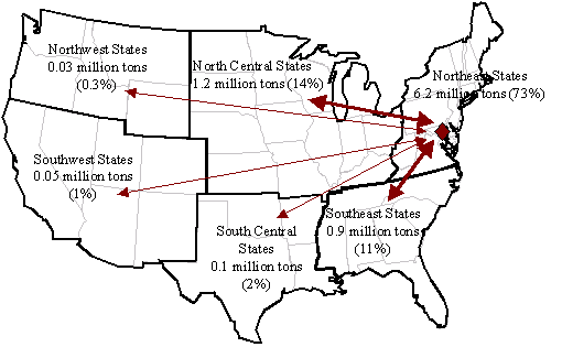
Figure C-5 illustrates domestic commodity flows by rail between Detroit and the rest of the U.S. Over half (58 percent) of Detroit's rail tonnage remains in the north central states and 27 percent moves to and from the northeast states. International rail flows are significant in the Detroit region and are not represented in Figure C-5.
Figure C-5: Rail Commodity Flows (domestic) To and From Detroit, 2003
Source: FHWA, Freight Analysis Framework.
The largest port in the region is the Port of Detroit, which has seven privately owned terminals located on the Detroit and Rouge Rivers. The region also has port facilities along the St. Clair River. The port handles approximately 17 million tons annually, 28 percent of it foreign, and ranks 40th among the nation's water ports as measured by tonnage.115 Most Port of Detroit freight (71 percent) remains within the Great Lakes, as shown in Table C-18.
Table C-18: Waterborne Commerce at the Port of Detroit, 2001
| Port of Detroit | ||
|---|---|---|
| Tons | Percent | |
| Foreign Imports | 4,465,000 |
26% |
| Foreign Exports | 261,000 |
2% |
| Lakewise | 12,028,000 |
71% |
| Internal and Local | 237,000 |
1% |
| Total | 16,991,000 |
100% |
Source: U.S. Army Corps of Engineers, Waterborne Commerce of the United States database.
The Detroit region has two major airports that handle freight: Detroit Metropolitan Wayne County (DTW) and Willow Run (YIP). DTW is the region's primary air cargo facility, handling 200,000 tons annually, as shown in Table C-19. DTW ranks 41st among the nation's cargo service airports in terms of landed weight of all cargo carriers. The Willow Run airport, located approximately tens miles west of DTW along the Detroit-Ann Arbor high technology and manufacturing corridor, handles approximately 3 percent of the region's air cargo.
Table C-19: Detroit Area Air Cargo Flows, 2003
|
|
Air Cargo (tons) |
||
|---|---|---|---|
| Airport |
Inbound |
Outbound |
Total |
| Detroit Wayne County (DTW) |
109,361 |
91,097 |
200,459 |
| Willow Run (YIP) |
2,089 |
3,186 |
5,274 |
| Total |
111,450 |
94,283 |
205,733 |
Source: Bureau of Transportation Statistics, Air Carrier Statistics T-100 database.
The Baltimore Metropolitan Council (BMC) is the metropolitan planning organization for the Baltimore metropolitan area. The region includes the cities of Baltimore and Annapolis and the five Maryland counties of Anne Arundel, Baltimore, Carroll, Harford, and Howard. The population of the Baltimore region was 2.6 million in 2002, an increase of 9 percent since 1990.116 The 2002 total employment in the region was 1.5 million.117 The Baltimore region is designated nonattainment for ozone (1-hour and 8-hour standard).
The private sector economy in the Baltimore region is led by the service sector. With the exception of construction, Baltimore has a relatively low concentration of industries that traditionally generate heavy freight activity, as compared to the other study regions.118 Manufacturing has a particularly low concentration in Baltimore. The largest manufacturing sectors in Baltimore are chemicals and computers & electronic products. High technology and biotechnology firms have reportedly grown rapidly in the region. 119
Table C-20 shows domestic commodity flows into and out of the Baltimore region by mode. The region is considerably smaller than the other five study areas in population and employment, and consequently, total freight flows to and from the region are the smallest of six study areas. Trucking carries 59 percent of Baltimore area interregional freight and marine vessels transport another 34 percent.
Table C-20: Commodity Flows Into and Out of the Baltimore Region, 2003
| Mode | Tonnage | Percent |
|---|---|---|
| Trucking | 76,821,000 | 59% |
| Railroad | 8,537,000 | 7% |
| Marine Vessel | 44,052,000 | 34% |
| Aircraft | 146,000 | 0.1% |
| Total | 129,556,000 | 100% |
Source: FHWA Freight Analysis Framework (trucking and rail); Bureau of Transportation Statistics, Air Carrier Statistics T-100 database (air); U.S. Army Corps of Engineers, Waterborne Commerce of the United States database (marine).
Trucking moves in the Baltimore urbanized area on a network of 288 miles of Interstate and other highways plus 374 miles of principal arterial roads.120 Major highways linking the region include I-95 (which runs from Florida to Maine), I-83 (which runs from Baltimore to Harrisburg, Pennsylvania), and I-70 (which runs from Baltimore to the Pennsylvania Turnpike in southwestern Pennsylvania). The I-695 loop encircles the city of Baltimore.
Table C-21 shows annual VMT in the Baltimore ozone nonattainment area by vehicle type for 2002. Heavy-duty trucks account for 7 percent of the region's total VMT, including 2 percent from gasoline trucks and 5 percent from diesel trucks.
Table C-21: Baltimore Area Annual VMT by Vehicle Type, 2002 (millions)
| Light Duty Vehicles |
Heavy-Duty Gasoline Trucks |
Heavy-Duty Diesel Trucks |
|
|||
|---|---|---|---|---|---|---|
| VMT |
Percent |
VMT |
Percent |
VMT |
Percent |
Total VMT |
| 21,449 |
92% |
547 |
2% |
1,271 |
5% |
23,267 |
Source: Annual VMT estimated by ICF Consulting based on 2002 average summer weekday VMT data provided by Baltimore Metropolitan Council.
Two Class I railroads (CSX and Norfolk Southern) and several smaller railroads operate in the Baltimore region. The region also hosts two switching and terminal rail companies, Canton Railroad and Patapsco & Back Rivers Railroad. CSX owns and operates several rail facilities in the Baltimore region, including rail switching yards and rail-to-truck and auto distribution centers (Annapolis, Curtis Bay, Fairfield, and Point Breeze). It also operates the publicly owned Intermodal Container Transfer Facility at the Baltimore port.121 Norfolk Southern owns a rail/truck intermodal facility and the Bayview Intermodal Container Transfer Facility and switching yard in the city of Baltimore.
Figure C-6 shows railroad commodity flows to and from the Baltimore region. Most rail freight (73 percent) remains within the northeastern states. Another 14 percent of rail freight moves between Baltimore and the north central states, and 11 percent moves to and from the Southeast.
Figure C-6: Rail Commodity Flows To and From Baltimore, 2003
Source: FHWA, Freight Analysis Framework.
The Port of Baltimore is the region's major maritime facility. Located near the northern end of the Chesapeake Bay, the port is accessible from the Atlantic Ocean through either the south end of the bay or through the Chesapeake and Delaware Canal. Because of the port's inland location, it provides access to more than 30 percent of the nation's population overnight by truck or within two days by rail.122 In 2002, the Port of Baltimore ranked 15th among the nation's containership ports, with a total of 508,000 TEUs, and ranked 21st nationally in terms of tonnage.123 Sixty percent of tonnage at the Port of Baltimore is foreign imports or exports, as shown in Table C-22.124
Table C-22: Waterborne Commerce at the Port of Baltimore, 2001
| Port of Baltimore | ||
|---|---|---|
| Tons | Percent | |
| Foreign Imports | 18,262,000 |
43% |
| Foreign Exports | 7,076,000 |
17% |
| Coastwise | 5,511,000 |
13% |
| Internal and Local | 11,212,000 |
27% |
| Total | 42,061,000 |
100% |
Source: U.S. Army Corps of Engineers, Waterborne Commerce of the United States database.
Table C-23: Baltimore Area Air Cargo Flows, 2003
|
|
Air Cargo (tons) |
||
| Airport |
Inbound |
Outbound |
Total |
|---|---|---|---|
| Baltimore-Washington International (BWI) |
79,717 |
66,420 |
146,137 |
Source: Bureau of Transportation Statistics, Air Carrier Statistics T-100 database.

