
FHWA Supports:


This document is designed to assist organizations conducting effective walking and/or bicycling road safety assessments in support of the Secretary's priority on pedestrian and bicycle safety.
Road safety assessments are safety examinations of transportation facilities by a multidisciplinary team. Although the focus of these assessments will be safety, USDOT realizes that without safe accommodations and infrastructure, access to vital public transportation systems and use of bikeways and walkways are impacted. Assessments are an effective method of observing safety issues and identifying potential physical and operational improvements.
The purpose of these assessments is to:
Facilitate and encourage relationship-building between people who work for the different jurisdictions that share responsibility for creating safer streets. Participants will experience challenges that non-motorized users face and have the opportunity to discuss the issues that are raised with Federal, State, local, regional, and transit agency staff, community representatives and advocates, and other stakeholders.
Engage practitioners who are not typically focused on pedestrian and bicycle safety. Although committed stakeholders and specialists with long-term experience on these issues should be engaged, the primary focus of the initiative is connecting engineers, planners, and highway safety professionals, helping them work together to consider non-motorized safety regularly and systematically in their work on all transportation and highway safety projects.
Focus on locations that have non-motorized safety challenges (e.g., major road or transit corridors, significant intersections, transit station areas). The best locations will be those already under consideration for roadway improvement or rehabilitation in the next State Transportation Improvement Program or Transportation Improvement Program. Furthermore, locations identified through the problem identification research conducted as part of the State's Highway Safety Plan may be good choices. For example, urban arterials are recommended locations because of the challenges they pose, the transit networks that serve them, and the often shared responsibility between State and local entities. More detail about site selection is included below.
Field assessments are intended to provide a practical, real-world environment to foster discussions, share knowledge, identify the patterns that result in gaps in the non-motorized network, and build relationships that will lead to safer pedestrian and bicycle networks over time - as the lessons discussed below illustrate. The assessments are aimed at extending pedestrian and bicycle networks, which are "interconnected pedestrian transportation facilities that allow people of all ages and abilities to safely and conveniently get where they want to go."
Based on the experience of previous pilots, DOT has developed the following proposed steps for hosting successful road safety assessments. More details on each step follow below.
Identify roles and partners: Consider the role of Federal staff early on and identify existing initiatives/funding to leverage (where applicable).
Plan the event: Pick a location (for example, arterial roads and transit area stations can be good candidates) with identified safety problems that involve a variety of stakeholders. Choose audience- and place-appropriate assessment tools.
Invite attendees: Reach out to stakeholders and practitioners at all levels, including those that are not traditionally involved in pedestrian and bicycle safety issues.
Conduct the event: Convene an event to present background information on the assessment location, review the assessment tool, conduct the assessment, and debrief with participants.
When identifying roles and partners for the assessment, consider:
What can Federal staff contribute to the assessment?
What are the key safety issues and concerns in your area that your agency influences (e.g., roadway design and operations, transit station access, bus stop access and crossings, visibility near intersections, educating law enforcement and the public, etc.)?
Are there existing efforts or initiatives at the State/regional/local level to connect to? What initiatives and/or safety focus areas could benefit from Federal staff involvement and an elevated profile?
Which jurisdictions/partners have the capacity and resources to host an event?
Working with key assessment partners, there are a number of decisions to make in advance of the event:
Location and Scale
Selected locations should be along corridors that are planned for improvement within the next five years, so that findings can be integrated with future plans. Locations with overlapping responsibilities between the State DOT, county and city transportation agencies, and transit providers also provide an opportunity to increase collaboration. Locations with identified high incidences of motor vehicle crashes with pedestrians and/or bicyclists are also excellent candidates.
Choosing an assessment tool
Each assessment should be conducted using an assessment tool. There are many assessment tools available - such as those listed below - from a variety of sources; choose and consider customizing tools based on context and audience. Links to assessment tools developed by USDOT and others developed with USDOT funding can be found below:
FHWA Pedestrian Road Safety Audit Guidelines and Prompt Lists (2007): http://www.pedbikeinfo.org/pdf/PlanDesign_Tools_Audits_PedRSA.pdf
FHWA Bicycle Road Safety Audit Guidelines and Prompt Lists (2012): https://safety.fhwa.dot.gov/ped_bike/tools_solve/fhwasa12018/
Pedestrian and Bicycle Information Center Road Safety Audit Resource Page: http://www.pedbikeinfo.org/planning/tools_audits.cfm
Select facilitators
Identify assessment facilitators with expertise in pedestrian and/or bicycle safety. Consider whether these individuals should have previous familiarity with or professional experience in the assessment location. While facilitators with close knowledge of the area may enable a more streamlined event, their expertise may dampen the engagement of assessment participants.
Select a route and travel mode
Develop a route that lets the group observe all relevant transportation modes in the area and observe different types of infrastructure or lack thereof (crosswalks, ramps, sidewalks, signals, multi-use trails, bike lanes, etc.). Ideally participants should experience the majority of the route by foot or bicycle.
A mixture of experts and people who have on-the-ground safety experience in the assessment area is helpful (e.g. station managers, law enforcement, etc.). The team may also consider inviting a broader audience, including pedestrian and bicycle advocacy groups, elected officials, and other advocacy and special interest groups.
When finalizing the list of invitees, consider which professionals and organizations in the community have the resources, influence, relationships, and motivation to convene or participate in the assessment. Also consider how the composition of the assessment group will support shared learning and relationship development.
Most road safety assessments consist of three elements:
An opening/introductory meeting with background information,
An organized and facilitated walking and/or bicycling safety assessment tour along a pre-determined route, and
A debrief session.
All three elements usually take place on the same day, but they could be divided. Be sure to include time for introductions, background information, the assessment, and a debrief session; tailor each to the experience level of the group.
Considerations for each of three basic meeting elements are noted below:
Opening/Introductory Meeting
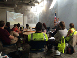 WalkBoston staff present at the Massachusetts pilot opening meeting.
Provide background and context to guide the assessment, such as:
Elements of the pedestrian/bicycle environment
Connection between vehicle speed and fatalities/injuries
Key concepts related to pedestrian/bicycle safety (e.g., speed, lighting, crossing/turning movements, dooring, etc.)
Information about local non-motorized counts
Mapped injury and fatality events and contributing factors from police reports (note any disproportional fatality and injury rates for specific populations)
Ideas/best practices for reducing vehicle speeds, including road diets, traffic calming, signal timing, etc.
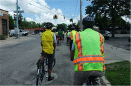 Participants bicycle during the Michigan pilot.
Think about the 3Es of transportation safety:
Engineering: signal timing, crosswalk and lane striping, intersection engineering, etc.
Enforcement: known issues or violations, opportunities for targeted enforcement to enforce roadways laws for all users.
Education: opportunities to educate all roadway users on traffic laws, safe practices, etc.
Use this opportunity to understand and discuss why this corridor does not have a safe non-motorized network in the first place. Consider what policies or practices might provide solutions to this problem, as well as what might be done to avoid the development of such gaps in the future.
Be sure to set sufficient time aside to debrief after the group walk or bike ride.
Depending on the size of the group, break out into multiple subgroups to facilitate discussion.
Discuss implementation next steps:
Identify and discuss approaches to improve collaboration (e.g., between departments of planning and public works)
Integrate the assessment recommendations into the city/county/State maintenance plans to increase likelihood of implementation
Discuss funding opportunities and emphasize that pedestrian and bicycle projects are eligible for many Federal-aid Highway and transit programs
Encourage a multimodal approach to street maintenance

