
Unmanned Aerial Systems Take Flight in Highway Transportation
When transportation agencies use unmanned aerial systems (UAS), they elevate their ability to collect accurate data rapidly and access hard-to-reach locations safely and cost-efficiently. While UAS are useful in many areas of highway transportation, in Every Day Counts round five (EDC-5) the Federal Highway Administration is focusing on helping agencies deploy drones for construction inspection, structural inspection, and emergency response.
Using UAS for construction inspection enables inspectors to capture a bird’s-eye view of a project’s progress while saving time and money and increasing productivity. Structural inspection with UAS enhances safety for the inspection team and traveling public by reducing the need for work zones. UAS also help agencies respond to and assess damage from emergencies faster and obtain quality data to make more informed decisions.
View a video on how the New Jersey Department of Transportation deploys UAS to increase safety and accuracy, accelerate data collection, and provide access to challenging locations.
To encourage deployment, the EDC-5 team is organizing workshops for State transportation departments that feature experts on UAS use cases of interest to the agencies. “These are popular because States can engage large numbers of staff and even local agencies they work with,” said James Gray, FHWA UAS and construction technology engineer and co-leader of the EDC-5 team. “We also plan peer exchanges between States with UAS programs to facilitate sharing of best practices and details on operations that might be new to one of the participating States.”
Eight States have institutionalized the use of UAS so far in EDC-5. They include the Utah Department of Transportation (UDOT), which deploys UAS for traffic incident management, mapping and surveying, bridge inspection, and construction administration. The New Jersey Department of Transportation, which received State Transportation Innovation Council Incentive funds to help institutionalize its UAS program, has used drones to obtain project management photos and videos, conduct a preconstruction survey of a rail line crossing, and aid response after a rockslide.
Survey Shows Rapid Deployment
A 2019 survey by the American Association of State Highway and Transportation Officials (AASHTO) found that 49 States use UAS technologies in some way and 36 States have hired UAS-related staff, including pilots and drone operations managers. The survey documented the top five UAS missions:
- Gathering photos and videos, mainly of infrastructure projects
- Surveying
- Inspecting infrastructure, including bridges, signage, light poles, and pavement
- Responding to emergencies and natural disasters
- Conducting public education and outreach
When AASHTO conducted its first UAS survey in 2016, no State transportation department had incorporated UAS into daily operations. “In 3 short years, we’ve gone from zero to 36 State DOTs executing drone missions internally,” said Jim Tymon, AASHTO executive director. “This giant leap is helping States work safer, smarter, and faster than ever before, and that adds up to big savings for taxpayers and improved safety for motorists.”
UAS Generate Savings
Twenty-nine States reported in the AASHTO survey that UAS help them save money. The Colorado Department of Transportation (CDOT) uses UAS to map geohazards such as rockfalls and landslides in more than 40 mountainous corridors. This cost-efficient way of capturing images remotely saves the agency 40 percent over traditional methods. “We’re able to capture large amounts of data in an entire corridor in a short amount of time,” said Ty Ortiz, CDOT geohazards program manager. “All that data helps us understand where and how to mitigate those geological hazards.”
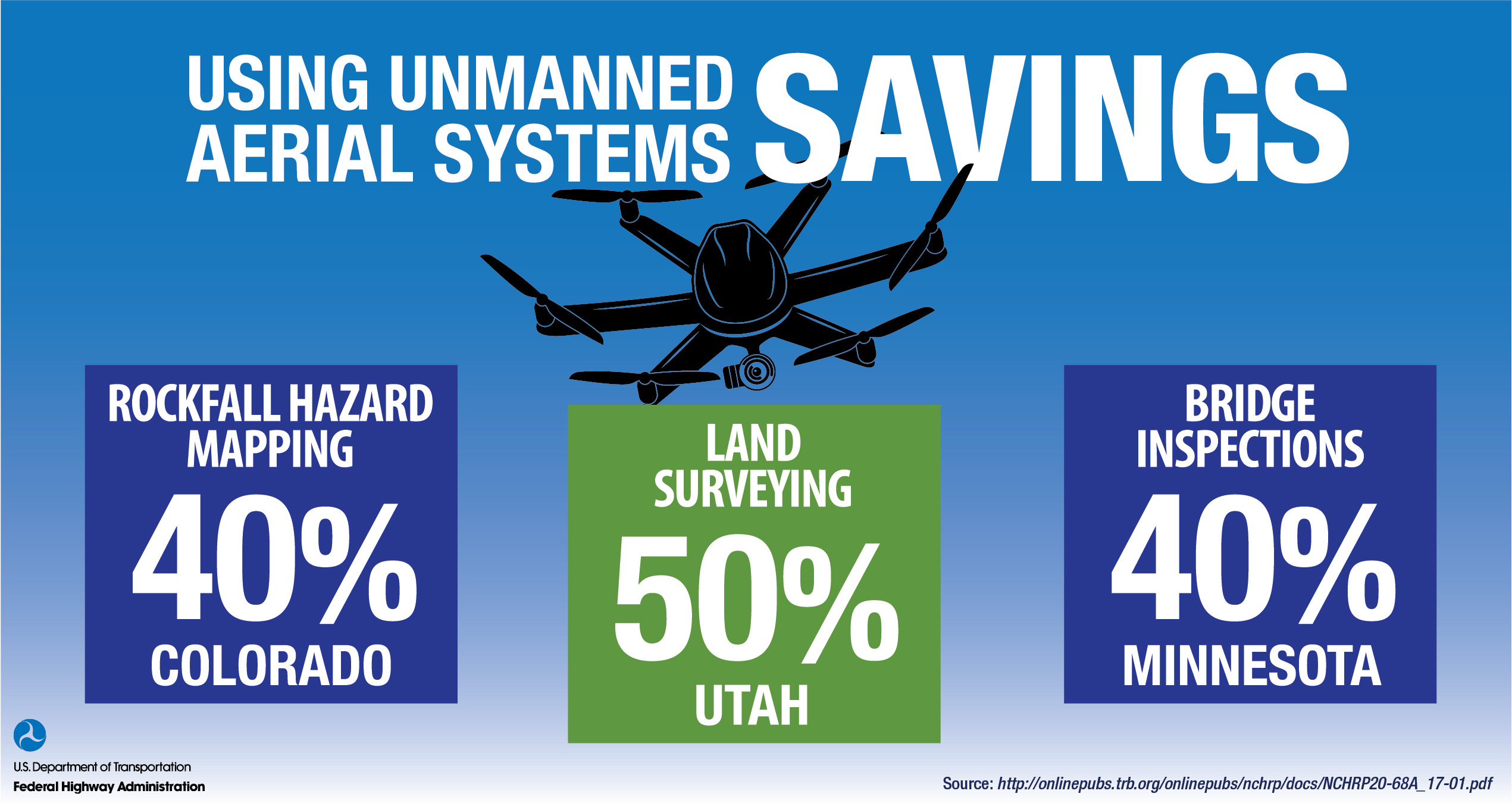
UDOT estimates that using UAS can reduce surveying time by as much as 50 percent while improving safety. “We did a job in Moab, where we’ve got 500- and 1,000-foot high cliffs, and trying to get a guy up on those cliffs is nearly impossible,” said Paul Wheeler, UDOT UAS program manager. “We were able to fly that and get that data, then supplement it with LiDAR on the roadway and combine the two.” Obtaining and processing the data took about 2 weeks, compared to a month with traditional surveying methods.
Since adopting UAS, the Minnesota Department of Transportation (MnDOT) reports average cost savings of 40 percent over traditional bridge inspection methods. Supplementing hands-on inspections with UAS also helps MnDOT improve data quality, especially for difficult-to-access bridge elements such as confined spaces, high wall abutments, steep slopes, and piers under traffic. UAS deliver infrared and three-dimensional modeling detail of bridges, identify concrete delamination, and gather topographic mapping detail.