U.S. Department of Transportation
Federal Highway Administration
1200 New Jersey Avenue, SE
Washington, DC 20590
202-366-4000
The North Carolina Department of Transportation (NCDOT) is pairing two Every Day Counts (EDC) innovations—weather-responsive management strategies and unmanned aerial systems (UAS)—to support its flood management efforts and make key decisions during disaster response.
NCDOT uses UAS for a variety of applications, including strategic situational awareness of infrastructure conditions, survey, and reconnaissance related to weather-related disasters. “This provides an understanding of what is happening on the ground, helping decision makers and leadership gain insight and information to make appropriate decisions on how to allocate resources and prioritize opening roads,” said Basil Yap, NCDOT’s UAS program manager.
The first time NCDOT used UAS to monitor a disaster was when Hurricane Florence struck in 2018. The agency deployed UAS to monitor flooding, road conditions, and traffic impacts. Flooding caused more than 2,400 road closures across the State, including multiday closures on Interstates 40 and 95.
In a week-long effort, 15 NCDOT UAS teams flew more than 260 missions and captured more than 8,000 photos and videos of damage and flooding left behind by the storm. Even after the storm ended, NCDOT’s UAS teams continued to assess flooded areas and provide updates, enabling the department to determine which roads were passable for the public and accessible to emergency responders.
NCDOT provided UAS-collected data, images, and video to Federal, State, and local agencies through an online dashboard. The information helped agencies make real-time decisions on providing emergency response, planning detour routes, assessing repair needs, and warning the public of potential dangers on roadways.
NCDOT also used traditional and social media to share information, including a tweet that went viral that showed a UAS-captured photo of what appeared to be a river stretching into the distance. “This isn’t a river, it’s a highway,” NCDOT said in its tweet encouraging travelers to avoid a flooded section of I-40.
View a webinar on how UAS and weather-responsive management strategies can work together for flood management.
Read a Federal Highway Administration TechBrief on how agencies are using UAS to respond to flood emergencies.
Contact James Gray of the FHWA Office of Infrastructure or John Haynes of the FHWA Utah Division for information on UAS.
Contact David Johnson of the FHWA Office of Operations for information on weather-responsive management strategies.
Transportation agencies are installing high-friction surface treatments (HFST), an early EDC innovation, as part of their focus on reducing rural roadway departures (FoRRRwD) and saving lives. They’re also using project bundling to reduce costs on HFST projects.
HFST is a cost-effective safety countermeasure in which a polish-resistant aggregate such as calcined (heat-treated) bauxite aggregate is bonded to the pavement surface using a polymer resin binder to improve and maintain pavement friction, helping motorists keep better control in dry and wet driving conditions. HFST is used at locations with high risk for crashes—such as curves, ramps, and intersections—to reduce crashes and the related injuries and fatalities.
South Dakota experienced five times more lane departure crashes involving winter road conditions than wet roads, so the South Dakota Department of Transportation (SDDOT) evaluated HFST as a lane departure countermeasure on horizontal curves with crashes involving conditions such as ice, snow, and frost. With the help of Accelerated Innovation Deployment Demonstration funds, SDDOT conducted a pilot project on four curves, including two on rural U.S. 14A in the Black Hills area.
In the 5 years after the HFST application on one of the rural curves—U.S. 14A near Sturgis—no crashes have been reported, compared to 12 crashes during the 5 years before the HFST project. “For the total project, we’ve seen an 80 percent crash reduction, so we knew HFST was something we needed to use more,” said Andy Vandel, SDDOT highway safety engineer.
Because of the success of the pilot project, SDDOT expanded HFST to 15 locations—most on rural roads—that experienced crashes with winter road conditions as a contributing factor and saw a 66 percent crash reduction over 3 years. SDDOT has added HFST to its safety countermeasure toolbox and plans two HFST projects every other year, bundling them by region to obtain better pricing than for individual projects.
To reduce the number of wet pavement and lane departure crashes on curves, the Pennsylvania Department of Transportation (PennDOT) has installed HFST at about 500 locations statewide, including rural roads. PennDOT’s HFST contracts usually include multiple locations and are typically contracted as a districtwide or countywide bundle to ensure good prices.
A PennDOT crash data analysis of 47 locations from seven contracts where HFST was installed found that for an investment of just over $3 million, the return in reduced fatalities, injuries, and property damage was more than $8.5 million. Injury crashes at these locations went from 190 to 71, a 63 percent decrease, and fatalities dropped from eight to zero. “We’ve never applied a countermeasure before and had no fatalities at any location afterwards,” said Jason Hershock, PennDOT’s manager for safety engineering and risk management.
Watch a webinar on how States are using HFST as a FoRRRwD countermeasure.
Contact Cathy Satterfield of the FHWA Office of Safety or Dick Albin of the FHWA Resource Center for information on the FoRRRwD initiative.
Contact Joseph Cheung of the FHWA Office of Safety for information on HFST.
Contact Romeo Garcia of the FHWA Office of Infrastructure or David Unkefer of the FHWA Resource Center for information on project bundling.
State Transportation Innovation Councils are turning to STIC Incentive funds to help them make new technologies and processes standard practices in their States. As a result, e-Construction is advancing in Wisconsin and New Mexico and geosynthetic reinforced soil-integrated bridge system (GRS-IBS) technology is now part of Arizona’s bridge-building toolbox.
The Wisconsin Department of Transportation (WisDOT) revamped and upgraded its Quantities 2 Plans (Q2P) application, a tool that supports the agency’s project estimating and e-Construction efforts. WisDOT developed Q2P to create a single repository of bid item data that maintains a live link between the engineer’s estimate, quantity calculations, and construction plan miscellaneous quantity sheets. In the STIC Incentive project, WisDOT rebuilt the original version of the application with extensive feedback from end users. In doing so, WisDOT enhanced Q2P’s efficiency, removed software bugs, and added new functions, such as integration with other e-Construction tools. The agency also increased the security of Q2P so it could make the tool available to consultants working on WisDOT highway design projects.
Q2P now better supports WisDOT’s e-Construction efforts by improving processes related to project estimating and paperless operations. Its auto-populating and auto-calculating functions save time and reduce manual data entry by about 60 percent while reducing the potential for manual data entry errors. WisDOT estimates that Q2P has the potential to save 3,000 hours a year over traditional, nonautomated methods. On larger projects that in the past required two engineers an entire day to manually enter a project’s quantities and estimate into preconstruction software, Q2P reduces the time and effort to one engineer for 1 to 2 hours.
WisDOT believes other transportation departments could modify Q2P for their own use in e-Construction processes. For information, contact David Esse of WisDOT.
The New Mexico Department of Transportation (NMDOT) used STIC Incentive funds to deploy mobile devices and software for e-Construction management on pilot projects. This enables construction inspectors to access contract information and complete tasks such as inputting daily reports while in the field. The software allows the creation of electronic PDF as-built plans in real time, eliminating the need to add the cost of developing post-construction plans to the contract. The software also improves partnering between NMDOT, contractors, and other stakeholders by increasing transparency of contract document transmission, distribution, and storage.
NMDOT estimates that using e-Construction management saves each inspector an average of 1.78 hours a day in travel time between construction sites and the project office to work on tasks such as filing reports and obtaining plan sheets. The agency estimates that if it used e-Construction management on all projects, the potential cost savings on inspection time for 112 inspectors and as-built plans for an average of 46 projects a year would total about $3.88 million over 3 years. For information, contact Jesus Sandoval of NMDOT.
The Arizona Department of Transportation (ADOT) used STIC Incentive funds to develop a construction specification for GRS-IBS, a rapid-construction, high-quality method of bridge support that blends the roadway into the superstructure. The agency developed the GRS-IBS construction specification to use on ADOT projects and serve as a tool for local agencies to adopt for their construction projects.

ADOT’s first use of GRS-IBS and the specification was on a project to replace the Interstate 40 bridge at Meteor City Road. The agency chose GRS-IBS for the project to get the work done faster, limit inconvenience for motorists, and reduce long-term maintenance costs. Using GRS-IBS made it possible for the project team to remove the existing twin structures, construct the new ones, and get them ready to open to traffic in 18 days. A traditional construction approach would have required a 3- to 4-month closure of I-40. Input from the project team enabled ADOT to revise and refine the GRS-IBS specification for use on future projects. For information, contact David Benton or Brent Conner of ADOT.
See more projects on the STIC Incentive web page.
Contact your State EDC coordinator for assistance on STIC Incentive funding applications.
Contact Sara Lowry of the Federal Highway Administration Center for Accelerating Innovation for information on the STIC Incentive program.
The South Carolina Department of Transportation (SCDOT) and Clemson University collaborated on an applied drone technology course that transportation professionals across the country can now access online.
Using State Transportation Innovation Council Incentive funds, SCDOT developed the 40-hour course to train its staff on the use of unmanned aerial systems (UAS). Although the course is tailored to SCDOT needs, the content is applicable to transportation professionals nationwide.
In an innovative pairing of perspectives that improved the curriculum, SCDOT staff and Clemson students worked together to learn UAS tools and techniques. The Clemson students benefited from the real-world experience of seasoned professionals and a firsthand view of working with transportation agency staff, while SCDOT staff were exposed to technology and applications the traditional students used.
Clemson delivered the course as both a traditional 15-week in-person class and as a 6-week online-live hybrid class. The course has four learning objectives:
The course development team found that using a UAS simulator was a critical complement to in-person instruction. One of the most challenging aspects of flying a UAS is scaling distances and knowing the proximity of obstructions. Program participants learned these key skills by repeatedly flying—and crashing—in a simulated environment. Students completed their flight training in person with commercial UAS aircraft using the National Institute of Standards and Technology open lane testing protocol.
The course development team held an outreach event for at-risk high school students to introduce them to UAS technology and spur interest in transportation careers. On “Drone Day,” high school students partnered with class participants at Clemson to fly UAS, collect data, and create a 3D model for as-built documentation.
Participants represented a range of SCDOT offices, including construction, communication, information technology, preconstruction engineering, planning, traffic engineering, survey, and maintenance. Through its professional studies program, Clemson now makes a self-paced version of the course available online. Clemson also offers an instructor-led online course and a one-day in-person flight training session.
Contact Dr. Joe Burgett, associate professor at Clemson University, for information on the applied drone technology course.
Watch a video overview of the course.
Contact James Gray of the Federal Highway Administration Office of Infrastructure or John Haynes of the FHWA Utah Division for information on UAS.
A new resource from the safe transportation for every pedestrian (STEP) initiative, STEP Studio is a toolbox for selecting and implementing countermeasures to improve pedestrian crossing safety. This visual and interactive resource follows the steps outlined in the “Guide for Improving Pedestrian Safety at Uncontrolled Crossing Locations” to identify potential countermeasures for a variety of contexts. STEP Studio connects users to case studies, research reports, videos, and Federal Highway Administration guidance that go deeper into the benefits and design considerations of enhancing pedestrian safety.
STEP has produced more than 30 case studies on the “spectacular seven” countermeasures: rectangular rapid-flashing beacons, leading pedestrian intervals, crosswalk visibility enhancements, raised crosswalks, pedestrian crossing/refuge islands, pedestrian hybrid beacons, and road diets. The case studies feature State transportation departments that developed crosswalk inventories and conducted systemic analyses to prioritize pedestrian safety improvements. They also share how local agencies integrate data into transportation plans and policies for improving pedestrian safety.
The FHWA Center for Local Aid Support released “Safe Transportation for Every Pedestrian for Local and Tribal Locations,” an 11-part online training resource based on the “Guide for Improving Pedestrian Safety at Uncontrolled Crossing Locations.” These interactive e-learning modules include quizzes on the STEP countermeasures.
Contact Becky Crowe of the FHWA Office of Safety or Peter Eun of the FHWA Resource Center for information and assistance on STEP countermeasures, including virtual workshops.
Every Day Counts storyboards communicate innovation deployment stories in an interactive digital slideshow—incorporating photographs, video, and graphics in a visual experience.
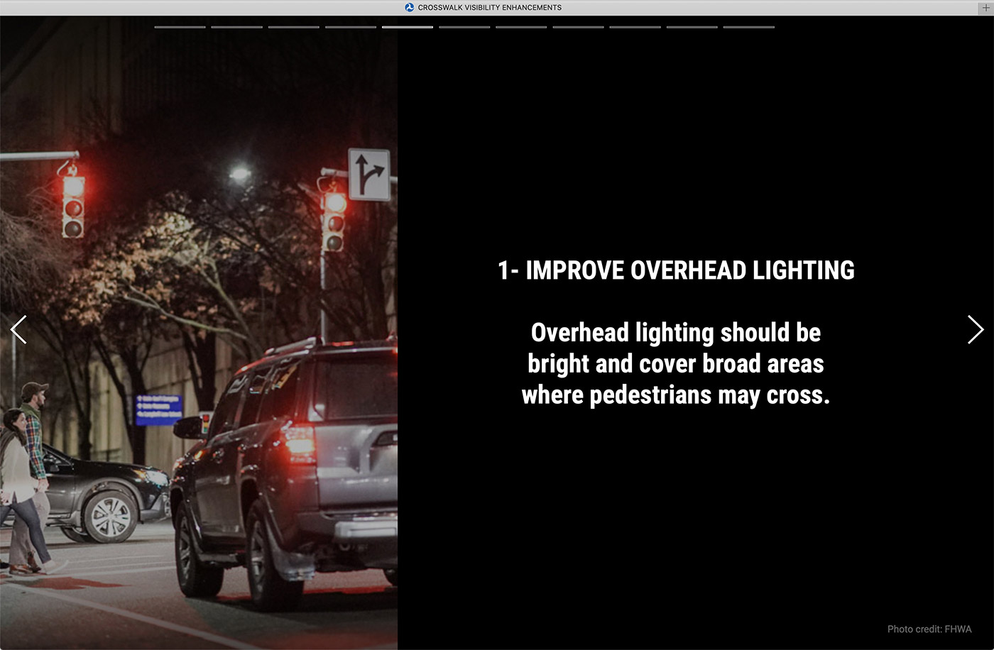
This storyboard promotes the use of crosswalk visibility enhancements to increase nighttime pedestrian safety. In 2018, 76 percent of pedestrian fatalities nationwide occurred in dark conditions. The storyboard proposes approaches such as improved overhead lighting, crosswalks with high-visibility markings, and rectangular rapid-flashing beacons to improve pedestrian visibility and safety at crossings in the dark.
Weather-responsive management strategies, community connections, roundabouts, and accelerated bridge construction (ABC) are among the Every Day Counts innovations highlighted in projects and programs honored in the 2020 America’s Transportation Awards regional competition.
Sponsored by the American Association of State Highway and Transportation Officials (AASHTO), AAA, and U.S. Chamber of Commerce, the annual competition showcases agency success in getting more out of the transportation system, deploying innovations, and improving quality of life.
As a weather-responsive management strategies approach, the Arizona Department of Transportation (ADOT) installed a dust-detection and warning system on a 10-mile stretch of Interstate 10. The first-of-its-kind system—part of an I-10/State Route 87 improvement project—is designed to warn drivers about poor conditions, encourage them to slow down, and reduce the risk of serious crashes in an area known for severe dust storms. The system includes overhead message boards, digital variable speed limit signs, closed-circuit cameras, and short-range detectors for blowing dust. Along with these measures, a weather radar dish sits atop a 22-foot pole at the SR 87 interchange to detect storms more than 40 miles away.
All of this technology is monitored by ADOT’s Traffic Operations Center in Phoenix, where staff can see real-time information on conditions such as the speed and flow of traffic. Closed-circuit cameras provide visual confirmation of roadway conditions. After a 30-day test period, ADOT made the dust-detection system operational at the start of the 2020 monsoon season, the peak time for severe storms that create hazardous driving conditions, and plans to evaluate the system’s success. ADOT expects the system to advance the agency’s knowledge of whether similar technologies would be effective on other Arizona highways.
The Connecticut Department of Transportation launched the Community Connectivity Program to support pedestrian and bicycle safety and accessibility in urban, suburban, and rural community centers across the State. The program provides funding to construct local initiatives that make roadway conditions safer for people to walk, bike, and use transit and strengthen community centers.
In one project, the city of Stamford used a Community Connectivity grant to improve transportation options and create a community space in Boxer Square, at the intersection of Stillwater Avenue and Smith Street. Stamford realigned the intersection to improve traffic operations and safety for all travel modes; provide safer connections to transportation options such as biking, walking, and public transit; and create a small park that incorporates the square’s namesake boxer statue. The completed project has encouraged new economic opportunities in the neighborhood and enhanced the quality of life for community residents and visitors.
Since the original Van Buren Street interchange with Interstate 90 was built in 1966, Missoula, MT, has experienced population growth that has resulted in increased traffic volumes. The interchange also has become a vital community connector, with the University of Montana, medical centers, and outdoor recreation options all within driving distance.
To accommodate this growth, the Montana Department of Transportation (MDT) constructed an interchange improvement project that included two roundabouts, circular intersections that promote a continuous flow of vehicles. MDT chose roundabouts to reduce congestion, vehicle conflict points, and the opportunity for crashes and plans to evaluate their effect. Beyond the roundabouts, MDT provided the community with more transportation options with the addition of a shared-use path that connects to a trail system. MDT also upgraded the landscaping to restore the ecosystem around the interchange, reduce water use and maintenance needs, and enhance quality of life.
To replace the Shaler Street Bridge over busy U.S. Route 19 in Allegheny County, the Pennsylvania Department of Transportation (PennDOT) chose self-propelled modular transporters (SPMTs), an ABC technology the agency had not used before. Because U.S. Route 19 carries 27,000 vehicles a day to and from downtown Pittsburgh, Interstate 79, and Pittsburgh International Airport, PennDOT considered minimizing closures during replacement of the bridge a necessity.
Crews assembled the new bridge beams and deck at a nearby site and used SPMTs—computer-controlled vehicles that can carry heavy loads and position them precisely—to move the prefabricated bridge components onto new support structures. Using SPMTs allowed completion of the bridge replacement in two weekend closures instead of the 6 months of corridor restrictions and closures needed for conventional replacement. The result provided the community with a safer bridge and PennDOT with a new tool for its ABC toolbox.
Contact Kaitlyn Meuser or Maggie Kasperski of AASHTO for information on America’s Transportation Awards.
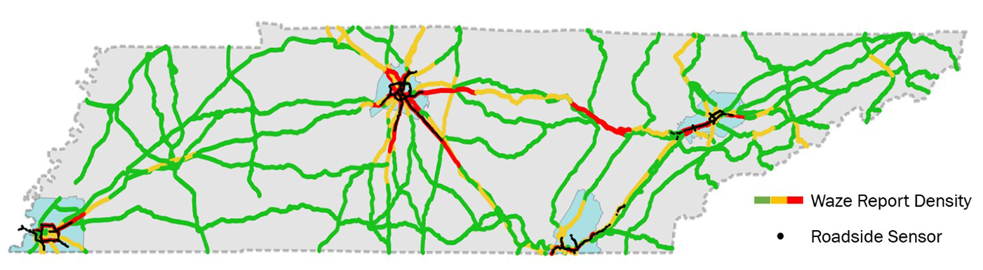
State transportation agencies are demonstrating the value of crowdsourcing for operations. The Tennessee Department of Transportation (TDOT) used crowdsourced data to detect crashes and stopped vehicles faster. In conjunction with the University of Tennessee, TDOT used Waze speed, incidents, and traffic jam data to enhance queue detection techniques that previously relied on traditional intelligent transportation system (ITS) roadway sensors. Adding crowdsourced data greatly expanded the geographic coverage area and timeliness of TDOT’s queue detection and response capabilities. The crowdsourced data enabled TDOT to identify the backs of queues 1.1 minutes faster on average than by just using ITS vehicle detectors and monitoring cameras at fixed locations.
By joining the Waze Connected Citizens Program (CCP), the Maryland Department of Transportation (MDOT) can more effectively share road closure incidents in real time with users of the application. MDOT has also begun archiving and analyzing crowdsourced data available through the CCP partnership for its potential to complement the agency’s robust traffic monitoring systems. Findings from data verification efforts are confirming the value of investing in this new data source. MDOT expects analyses will inform future ITS infrastructure deployment, while real-time information will help more quickly detect and respond to incidents on freeway and arterial facilities.
Because 40 percent of rural roadway departure crashes occur on locally owned roads, many State transportation agencies are helping local agencies reduce rural roadway departures. The Ohio Department of Transportation (ODOT), with assistance from the Ohio Local Technical Assistance Program, administers the Township Safety Sign Grant Program. This systemic curve signing upgrade program helps ODOT reach the 84 percent of roads not on the State highway system. Townships with a greater-than-average crash rating over the previous 5 years are eligible to apply for up to $50,000 each in safety sign materials with no required local match. From 2015 to 2019, more than 225 townships participated in the program. An evaluation of crash data in 24 townships that installed signs in 2015 showed a 67 percent reduction in fatalities and 33 percent drop in serious injuries in the 2 years after deployment, compared to statewide crash increases in fatalities of 9 percent and injuries of 11 percent.
Pennsylvania Department of Transportation (PennDOT) data show that fatalities, injuries, and crashes decreased overall at 22 roundabouts built at 19 locations that were previously stop or signal controlled. The agency evaluated roundabouts with at least 3 years of crash data available before and after the roundabouts were built. The data show that fatalities at these locations were reduced by 100 percent, serious injuries (as defined by the U.S. Department of Transportation’s Model Minimum Uniform Crash Criteria) dropped by 77 percent, and the total number of crashes decreased by 21 percent. In addition to the 22 roundabouts reviewed, PennDOT has built 34 other roundabouts and has over 40 more in design. PennDOT created a video to educate road users on how to use roundabouts, whether in a vehicle, on a bicycle, or on foot.
The West Virginia Department of Transportation (WVDOT) has used unmanned aerial systems (UAS) to save money on calculating stockpile material quantities. WVDOT acquired its first UAS to test the viability of measuring stockpile material, and the State’s program has grown steadily since then to inventory 150 sites a year. Historically, this labor-intensive process involved surveyors and engineers. In 2019, the State inventoried the sites using UAS and seven pilots. WVDOT saved $340,000 in man-hours alone, and the agency estimates that overall savings were likely higher when including factors such as the surveyors and engineers being available to complete other work during the inventory.
Registration is open for the Every Day Counts round six (EDC-6) summit. This year’s event will be held virtually in three half-day sessions on December 8, 9, and 10.
An integral component of EDC, the summit brings together transportation leaders and frontline professionals responsible for developing and delivering highway projects. We welcome participation from all of our partners—State transportation departments, local agencies, Federal land management agencies, tribes, and industry.
The seven initiatives we’ll feature at the EDC-6 summit include strategies to increase engagement with people, new applications of products to preserve and repair infrastructure, and improved processes to save time on project delivery and incident management. An innovation showcase will highlight homegrown ideas being deployed across the country.
Innovator, published by the FHWA Center for Accelerating Innovation, advances implementation of innovative technologies and accelerated project delivery methods in the highway industry. Its audience is transportation professionals in highway agencies, trade and research groups, academia and the private sector, and the driving public.
Elaine L. Chao, Secretary, U.S. DOT
Nicole R. Nason, Administrator, FHWA
Thomas Harman, Director
Jeffrey Zaharewicz, Senior Advisor
Sara Lowry, Program Coordinator
Fawn Thompson, Program Coordinator
Julie Zirlin, Program Manager
Ellen Schweppe, Managing Editor
James Cline, Jr., Designer
Pat Holcombe, Designer
Rodney Walker, Designer
Access past issues in the Innovator Archive and have the next issue sent to your mobile device by texting “FHWA Innovation” to 468311. Email reprint requests to Julie Zirlin.

