Baltimore Metropolitan Council (BMC) Activity-Based Travel Model Peer Review Report
3.0 Development of the Baltimore Region Transportation Model
This section of the report provides an overview of the existing BMC transportation model, including a brief description of the current version of the model, the latest enhancements made to the model, and limitations of the model. Previous peer reviews and BMC's goals for the current peer review are also discussed here.
The current Baltimore Region Travel Demand Model is a four-step trip-based model that runs on the CUBE Voyager software platform. In addition to the MPO areas (i.e., Baltimore City, Annapolis City, Anne Arundel County, Baltimore County, Carroll County, Harford County, and Howard County), the model includes Montgomery County, Prince George's County, Frederick County, and Washington D.C (see Figure 3‑1). The model has 1,809 transportation analysis zones (TAZs): 1,387 in the Baltimore region, 380 in the Washington region, and 42 are external zones. The model considers seven trip purposes as follows:
- Home-based work,
- Home-based school,
- Home-based shop,
- Home-based other,
- Non-home-based (NHB) journey to/from work,
- Non-home-based journey at work, and
- Non-home-based other.
The time periods that are modeled include:
- AM peak (6:30 - 9:30),
- Midday (9:30 - 3:30),
- PM peak (3:30 - 6:30), and
- Night (6:30 pm - 6:30 am).
The model system underwent a major overhaul in 2006 with enhancement to the mode choice model (nested mode choice model) and inclusion of a toll choice model. The model was validated against observed data for the year 2000 (the report is available here: http://www.baltometro.org/reports/ValidationV3point3.pdf), and again more recently against 2008 data.
Despite all these enhancements and updates, the existing trip-based model for Baltimore has been deemed inadequate to fully address the agency's current and future transportation needs. Some of the limitations of the trip-based model are highlighted below:
- Modeling inter-regional interaction between Baltimore and Washington D.C., York County, and Pennsylvania. Related issues include:
- Balancing urban area trip purpose productions and attractions.
- Effect of difference in Cooperative Forecasting[3] methodology/assumptions between metropolitan regions. For example, inter-regional labor force movement.
- Representing transit in Washington D.C.
- Modeling congestion pricing. Related issues include:
- Distribution of value-of-time (VOT).
- Direct comparison of toll alternatives and transit.
- Tunnel/bridge toll choice - regular fare/commuter discount.
- Income and value of time differences between Baltimore and Washington region.
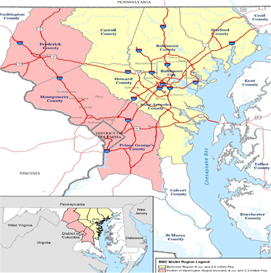
Figure 3‑1: BMC's Trip-Based Transportation Modeling Area
- Modeling transit oriented development. Related issues include:
- TAZ structure.
- Estimation of non-motorized trips.
- Land use effects on travel choices and travel choices effects on land use.
- Modeling mode choice. Related issues include:
- Representing central business district (CBD) with a dummy variable.
- Modeling commuter rail and local/fixed rail service.
- Modeling walk access/egress time.
- Network assignment. Related issues include:
- Fixed number of iterations for network convergence and feedback.
- Four Time Periods: AM peak, PM peak, mid-day, and overnight.
- Modeling delay and peak spreading.
- Summarizing outputs.
- Other issues include:
- Generating light and heavy truck and commercial vehicle based on Quick Response Freight Manual (QRFM).
- Limited information on special generators (regional shopping malls, universities, intermodal transfer facilities), external travel, and visitors.
- Modeling air passengers.
- Segmentation of base and future year income class.
- Connecting the MOVES emission model with the travel demand model.
In addition to a passenger travel demand model, the agency also has a trip-based truck model.
In the last decade, the agency hosted two previous peer reviews: one in September 2004, and another one in February 2005. A brief overview of these previous peer reviews is provided below.
- First Peer Review: This was a two-day review held in September 2004. The key focus of the review was to evaluate the status of the BMC travel model improvement process and to provide guidance on near-term and long-term model development issues. The Panel provided recommendations on a number of subjects/issues including population and employment forecast, mode choice validation, external and port-related truck survey, treatment of trips to the airport, and time-of-day/feedback related issues.[4]
- Second Peer Review: This was a one-day Peer Review that took place in February 2005. In this review, the agency asked the panel to evaluate their existing travel demand forecast model, make recommendations for model enhancements, and review their model improvement process. The panel's recommendations included advice on traffic analysis zone, employment and population data, demographic factors to be considered to improve the explanatory power of the model, and run time/speed of the model.[5]
BMC's activity-based travel demand model is currently at an early stage of development. The agency applied for and organized the peer review to seek guidance and advice from an independent panel of experts on the following specific subjects and issues:
- How travel response to toll/pricing should be represented and modeled? Mode choice and route choice, or route choice only?
- What spatial resolution should be used for discrete choice models? Parcel, micro-zone, or traffic analysis zone?
- At what spatial resolution for overlapping areas covered in the BMC model but part of Metropolitan Washington Council of Governments (MWCOG) juridsctions be modeled, given that there are inconsistencies between BRTB and MWCOG data?
- How the transit modes should be defined?
[3] The Cooperative Forecastings are made by a subcommittee of the BRTB called the Cooperative Forecasting Group. The Group is responsible for developing population, households, employment, and labor force projections for the MPO region in conjunction with Metropolitan Washington Council of Governments (MWCOG).
[4] The report on the first peer review is available at: http://www.fhwa.dot.gov/planning/tmip/resources/peer_review_program/bmc/report1/index.cfm
[5] The report on the second peer review is available at: http://www.fhwa.dot.gov/planning/tmip/resources/peer_review_program/bmc/report2/index.cfm


