U.S. Department of Transportation
Federal Highway Administration
1200 New Jersey Avenue, SE
Washington, DC 20590
202-366-4000
Federal Highway Administration Research and Technology
Coordinating, Developing, and Delivering Highway Transportation Innovations
 |
| This report is an archived publication and may contain dated technical, contact, and link information |
|
Publication Number: FHWA-RD-95-197
Date: December 1996 |
Development of Human Factors Guidelines for Advanced Traveler Information Systems and Commercial Vehicle Operations: Comparable Systems Analysis
CHAPTER 5. THE NAVMATE SYSTEM
GENERAL SYSTEM DESCRIPTION AND OBJECTIVESUSER INTERFACEDESIGN GUIDELINES USEDLESSONS LEARNED
GENERAL SYSTEM DESCRIPTION AND OBJECTIVESNavmate is an in–vehicle ATIS prototype system designed by Zexel USA Corporation to allow drivers the capability of reaching a specific destination from any place of origin. The information obtained for this system originated from three sources: a one–page brochure of Navmate given to drivers; an interview with a member of the design team; and a modest usability study with eight drivers, including three authors of this report. The Navmate analysis relies considerably on the heuristic analyses performed by the authors while performing probe tasks and driving tasks. Verbal protocols from the analysts and other subjects were recorded as the tasks were performed and subsequently transcribed. Navmate is a route planning and navigation system that is currently undergoing fieldtesting by Zexel and Avis in San Jose, California. The Navmate is a single–destination system that utilizes a combination of vehicle location techniques and provides the driver with turn–by–turn route guidance information en route to the selected destination. Drivers can select from a number of destinations by proceeding through various text–based menu screens and selecting a point of interest or a particular intersection from a database. A driver also may enter a street address as a destination. Once a destination is entered, Navmate calculates the fastest route, taking into consideration distance, posted speed limits, number of intersections, and left/right turns. The route is displayed on a digital map showing varying levels of detail contingent on the driver–selected map scale. The smallest scale displays one complex intersection (e.g., a cloverleaf freeway interchange) in its entirety on the screen. Table 4 denotes the functional characteristics of the Navmate system as compared to ATIS systems. Currently, the Navmate system is mostly an IRANS system that primarily provides navigation and route guidance information based on position information and map databases. However, the hardware configuration of the system renders it capable of adapting to future software systems that can provide several other ATIS functions. Plans are in progress to develop a version of the Navmate system capable of two–way communication.
Table 4. Comparison of Navmate functions with those from ATIS/CVO systems.
USER INTERFACEGeneral DescriptionThe Navmate unit has a 9–cm x 6.25–cm, 16–color, LCD display that provides both text– and map–based information to the driver. The display unit can be attached to the dashboard with a special mount such that it is located to the right of the driver, near the top of the dashboard. The display unit swivels and adjusts horizontally and vertically. The current Navmate prototype, including all hardware, wiring, and antenna, is designed to be installed in a test vehicle (e.g., rental car) in less than 1 hour without making any permanent modifications to the vehicle. The display is mounted onto the dashboard using existing screws in the vehicle. Therefore, the location of the display is contingent upon the location of existing screws. The GPS unit and other hardware are mounted in the trunk. The adaptability of this quick–installation design allowed the prototype to be tested in several vehicle models. The display unit has several discrete–setting controls that provide access to the screen displays and control cursor movement. The entire unit is approximately 14 cm wide and 14.5 cm high. The system utilizes a combination of positioning techniques, including the Global Positioning System, dead–reckoning, and map–matching. It provides the driver with real–time vehicle location and route guidance information as the driver progresses to a selected destination.
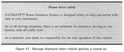
Visual Information DisplayWhen the ignition of the vehicle is in the "On" position, power is available to the Navmate. When power is available and the Navmate's "On/Off" switch is turned to "On", an introductory message is displayed. This message notifies the driver that he/she should always drive defensively and implies that the device should not hinder driving safely (figure 43). Once the driver acknowledges the message, the main "Where do you want to go?" menu is displayed. All the menus are text–based and presented with color schemes to enhance visibility and contrast. While most of the text is white on a black background, several portions of the display (header and help boxes) make use of other color schemes on a colored background.
The main menu screen is accessible when the vehicle is stationary or in motion. It allows a destination to be selected. From the main menu, the driver has four options for choosing the desired destination:
The desired selection is chosen by moving the cursor (highlighted box) to the item and pressing ENTER. At the bottom of the screen, an instructional line indicates the manner in which the driver can make his/her selection. Icons of arrows represent cursor controls. "Points of Interest" is the most frequently used category. The directories under "Points of Interest" included the following:
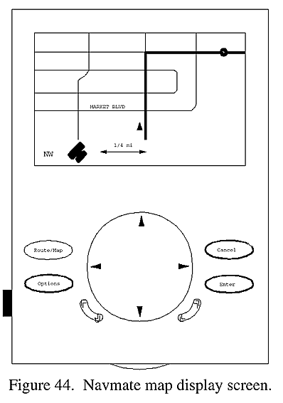
After a specific destination directory is selected (e.g., Restaurant), the system requests that the driver "Select the Listing Mode." The driver is capable of listing each directory alphabetically or by distance (the closest restaurant at the top of the list). When directory items are listed, the driver can scroll through the selections until the desired destination appears in the fixed highlighted box. As selections are highlighted, the direction, distance, and address (and city) of that selection are displayed at the top of the screen. Once the driver enters the desired destination (e.g., Mr. Right's Cafe), the system displays a message indicating that it is calculating the shortest route. This may take several seconds, depending on the distance to the destination. Once the route is calculated, a map–based display is shown with the route highlighted in magenta (figure 44). All local streets are white, freeways are light blue, and the background is black. Street names are in yellow. At the bottom of the map display, the compass direction in which the vehicle is heading (e.g., NW), the GPS status icon, and the map scale icon are shown in green.
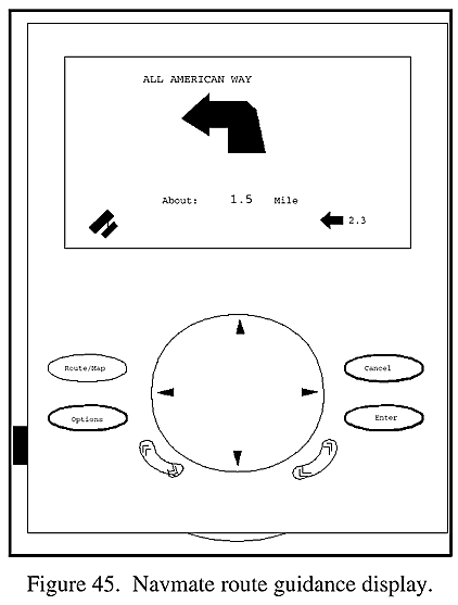
The map displays the position of the vehicle with a triangle indicating the vehicle heading. The driver can select to have the map displayed in either the heading–up or North–up orientation. Most drivers seem to prefer the heading–up mode. The location of the destination is depicted with a solid dot. Once the destination has been selected and the route is established, the driver is not capable of altering the route; however, he or she can select a new destination. The driver also can change the system's setup (e.g., the map scale) or switch between the map and route guidance screens. When the vehicle begins to move, the system automatically switches from the map to the route guidance screen (figure 45). The driver does have the option, however, of selecting the map display while in motion. The route guidance display provides turn–by–turn instructions for proceeding to the destination. The guidance display indicates the name of the street for the next turn at the top of the screen in uppercase letters. Underneath is a large yellow arrow indicating the direction of the next turn. Just below the arrow, the approximate distance to the next turn in displayed in miles. A yellow bar appears at the bottom of the guidance screen when the vehicle is 0.3 km from the next turn, and shrinks as the turn is approached. To the lower right of the screen, the direction of the destination from the current position is indicated with a small arrow in white. Next to it is the "as the crow flies" distance to the destination. The same GPS status icon from the map display is shown on the lower left.
If the driver leaves the planned route for any reason, the system displays a message indicating that the driver has "Left the Route" and also asks whether a new (alternate) route should be calculated to the same destination from the current position. The driver acknowledges this request simply by pressing ENTER.
Auditory Information DisplayA digitized male voice provides route guidance information to support visually displayed information at two volume levels (low or high), or it can be deactivated. When the vehicle approaches a turn (0.16 to 0.80 km away, depending on the vehicle speed), the system provides a voice announcement such as "Left Turn Ahead." A short auditory beep is emitted when a key is pressed, providing feedback that the function is engaged. Longer beeps are emitted when the system cannot respond to the key activated. A short beep is also emitted just before each voice message. All beeps seemed identical in pitch and loudness, and intensity was not adjustable. Two short beeps are emitted just before the vehicle reaches a turn.
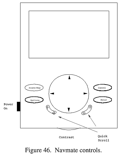
User Input (Controls)The Navmate system has several discrete controls located below the display (figure 46). All cursor movements are controlled by activating a large, circular, four–way, rocker control. To activate "Quick Scroll," the driver has to simultaneously press the rocker key and either of the Quick Scroll buttons. Several drivers seemed to have difficulty with this function. The four–arrow control is also used to relocate the vehicle position on the display when a miscalibration occurs (this may occur due to a weak GPS signal). The ENTER control activates the highlighted feature, and CANCEL acts as an "escape" function, allowing the driver to return to the previous screen or to abort a route calculation. The ROUTE/MAP button allows the driver to switch back and forth between the map and guidance screens while driving. The OPTIONS key is used to change the system settings for map size (small, medium, large), map orientation (heading up, North up), and Voice Volume (high, low, off). These setup settings may be changed while the vehicle is in motion.
Communications SystemsAt the present time, Navmate is a one–way communication system (GPS receiver) and does not transmit any signals or information. The map database must be updated by physically loading new databases. Cognitive DemandsThe majority of the system navigation and destination selection functions are normally performed when the vehicle is in PARK or at zero speed. Under normal conditions of use (i.e., destination is selected while parked), very few control inputs are used while driving; thus, the cognitive demands are limited to the time–sharing requirements of glancing at the display under various traffic conditions. The map display is difficult to interpret with a quick glance and can increase attentional demands on the driver. Normally, the simpler guidance display is used while in motion. Because of the simplicity of the guidance display and the distance cuing provided by the speech system, there is no need to look at the display frequently. The two beeps at the moment of the turn reduce the need to watch the display for distance information immediately prior to the turn. In short, the cognitive demands imposed by the Navmate system are not high as long as the driver selects the destination while parked.
System Temporal RequirementsThe display change that requires the most amount of time is the calculation of a new route. At times, this can take several seconds (up to 30 seconds) and can lead to user frustration. The map display also takes several seconds to update as the vehicle makes a turn. This is likely to occur when making a U–turn or turning around in a parking lot.
DESIGN GUIDELINES USEDHuman Factors Design GuidelinesThe Navmate design team was composed of 15 to 20 members with backgrounds in various areas of engineering, such as hardware, software, or computer science. Human Factors engineers were not involved in the design of this system, except for a Human Factors consultant who was asked to briefly evaluate the system's interface. This input was not part of a formal evaluation and the consultant did not participate in any rapid prototyping of or experimentation on Navmate.
Other GuidelinesThe design of the system seemed to revolve around a "passive system" that would not require input from the driver once the controls were set. The design of the displays also followed this "passive system," providing simplified turn–by–turn guidance; therefore, the driver would not be required to attend to the screen frequently or for long periods of time. Zexel design team members recognized that rental car users are likely to be novice users of the system, and too many controls could be intimidating. The interface was designed to "look easy to use." Cost was a constraint in the design. The availability of small, low–cost, color displays constrained the system to using fewer colors and lower resolution than desired. Since all graphics and text were drawn by Zexel, the design was only limited by the screen size, resolution, and color capability. Anti–glare devices are also expensive and Zexel opted for using gray filters rather than polarizing filters. Available technology also impacted the design of Navmate. The infrastructure was not available to provide real–time traffic information. In the future, Zexel plans to use a cellular phone to provide automated destination coordination. Route searches also were not as exhaustive as desired. The present Navmate route search is limited to reduce the amount of time needed to make a larger search. It was anticipated that rental car drivers would not be patient during long search times; therefore, it is possible that the best route (e.g., freeway around a city) is not selected. Other technology constraints involved the inaccuracy of GPS systems, which can introduce a position error as large as 100 to 300 m. Furthermore, the GPS signal is lost in many situations (e.g., parking garages, tunnels, tall buildings). To compensate for this error, several on–board systems were integrated. Data from the car's odometer and from a gyrometer in the Navmate system are used with dead–reckoning and map–matching technology to attempt to reduce position error. Updates and modifications to the present Navmate prototype will be made contingent upon the feedback from the current field tests. Customer Satisfaction Surveys completed by rental car users are expected to provide valuable information, including ease of use, ability to reach destinations, ease of entering destinations, and overall system performance. Drivers also are asked the price that they would pay to have the Navmate system installed as optional equipment in a new vehicle (i.e., $999 to $1,999).
LESSONS LEARNED[NM 01] SIMPLE USER ACCESS TO LARGE DATABASES IS ESSENTIAL
[NM 02] DETAILED ACCURACY OF MAP DATABASE MUST BE MAINTAINED
[NM 03] ENTIRE ROUTE PREVIEW IS DESIRABLE
[NM 04] DRIVERS WOULD LIKE TO BE ABLE TO REJECT UNVIABLE ROUTES
[NM 05] AUTOMATED STREET SEARCH WAS VALUED WHEN ENTERING ADDRESS DESTINATION
[NM 06] BUTTON FEEDBACK CAN IMPROVE PERFORMANCE
[NM 07] DRIVERS SHOULD BE NOTIFIED WHEN VEHICLE POSITION CALIBRATION IS REQUIRED
[NM 08] ROUTE DEPARTURE NOTIFICATION SHOULD BE PROVIDED VERBALLY AND VISUALLY
[NM 09] SOME DISPLAY SYMBOLOGY WAS CONSISTENTLY IGNORED BY DRIVERS
[NM 10] COMPUTING/WORKING INDICATION WOULD CLARIFY SYSTEM STATUS TO DRIVERS
[NM 11] ACCURACY OF MAP DATABASE IS CRITICAL IN ESTABLISHING DRIVER CONFIDENCE
[NM 12] DISPLAY MODE CHANGES SHOULD BE UNDER USER CONTROL
[NM 13] ROUTE GUIDANCE MODE PREFERRED FOR DRIVING
[NM 14] COLOR CODING OF ROUTE WAS HELPFUL
[NM 15] DISPLAY MOUNTING LOCATION WAS ADEQUATE
[NM 16] LEARNING REQUIREMENTS WERE FEW
[NM 17] TRAINING AIDES SHOULD BE USED AS A REFERENCE INSTEAD
[NM 18] DIGITAL SPEECH SYSTEM WAS INTELLIGIBLE
[NM 19] PREFERRED MAP ORIENTATION WAS HEADING UP
[NM 20] DRIVER PERCEPTION OF INTERFACE MAY IMPACT USE
[NM 21] MINIMAL DISPLAY CLUTTER ENHANCES PERFORMANCE
[NM 22] ATIS SYSTEM USE AT NIGHT WAS EXTREMELY VALUED
[NM 23] REDUCTION OF DISPLAY GLARE WAS SUCCESSFUL
[NM 24] DIRECT DISPLAY GLARE AT NIGHT WAS NOT A PROBLEM
[NM 25] COMMENTS ON VOICE MESSAGE TIMING VARIED
[NM 26] SUPPLEMENTAL VOICE ROUTING MESSAGES HELPFUL
[NM 27] DRIVER–REQUESTED ROUTE INFORMATION
[NM 28] DRIVER–REQUESTED TRAFFIC CONTROL INFORMATION
[NM 29] COMPUTING AN ALTERNATE ROUTE TO A GIVEN DESTINATION
[NM 30] SELECTING NEW DESTINATION AND ROUTE WHILE EN ROUTE
[NM 31] TURN INDICATORS SHOULD REFLECT ROADWAY CHARACTERISTICS
[NM 32] CONSECUTIVE TURN INFORMATION WAS VALUABLE
[NM 33] REAL–TIME DISTANCE TO A TURN WAS VALUABLE
[NM 34] FALSE ROUTE DEPARTURE NOTIFICATION SHOULD BE MINIMIZED
FHWA-RD-95-197 |