

| << Previous | Contents | Next >> |
ACTT Workshop: Utah
Spanning the Future
[Archived] Chapter 2: Project Details
2.1. Corridor Description
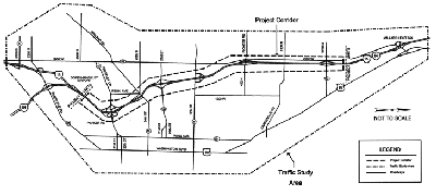
The I-15, 31st Street to 2700 North, Weber County, Utah, project encompasses 9.3 miles of Interstate and 28 bridges, including eight that run over railroad facilities and three that carry the rail over I-15. The projected level of service for the project corridor through 2030 is "E" from 450 North to 2700 North and "F" for 450 North to the Interstate 84 (I-84)/I-15 interchange, denoting service levels below an acceptable rating of "C."
The EIS process was begun in 2001 and completed in the fall of 2004. The preferred alternative is a composite of several mainline and interchange options:
- Mainline. Reconstruct and widen the I-15 mainline from the northbound ramps of I-84 to 450 North/Pioneer Road, and widen I-15 from 450 North /Pioneer Road to 2700 North. Provide four travel lanes in each direction from I-84 to 12th Street and three lanes in each direction from 12th Street to 2700 North.
- 31st Street Interchange. Reconfigure the existing cloverleaf interchange with either an SPUI interchange or a diamond interchange. The specific interchange design will be determined during the final design process.
- 24th Street Interchange. Retain the existing half-diamond interchange; correct ramp influence areas; install a traffic signal at Midland Drive/2550 South; and construct a connector road between 24th and 21st Streets on the east side of I-15.
- 21st Street Interchange. Retain the existing diamond interchange, and correct the ramp influence areas.
- 12th Street Interchange. Replace the existing jug-handle interchange with a diamond interchange or an SPUI interchange. The specific interchange design will be determined during the final design process.
- 450 North/Pioneer Road Interchange. Retain the existing diamond interchange; correct ramp influence areas; improve sight distance at ramp termini by lengthening the mainline bridge; and install a traffic signal at the northbound on-/off-ramps.
- 2700 North Interchange. Retain the existing diamond interchange; reconstruct the mainline in the vicinity of the interchange (including structures); and make ramp improvements. The new I-15 structures will accommodate the widening of 2700 North, which is a separate project.
- Other Improvements. The list of betterments also includes ITS elements, noise barriers, work on pedestrian crossings, trail enhancements (where associated with structure replacements), and realignment of the Union Pacific Railroad (UPRR) line south of 31st Street.
The estimated cost for constructing the alternative described above is $235 million. UDOT plans to stage construction in phases to address timing and funding issues. Phase I will include the following at an estimated cost of $173 to $177 million:
- Reconstructing/widening I-15 from the northbound ramp of I-84 to 700 South to include four lanes in each direction between the northbound ramp of I-84 and 21st Street and three lanes in each direction between 21st Street and 700 South. UDOT also plans to construct an embankment for a fourth lane in the median between 21st Street and 12th Street.
- Implementing interchange improvements between 31st Street and 12th Street. This does not include construction of the connector road.
Pre-workshop plans show construction tentatively scheduled to begin in 2006.
Figure 1: Project Corridor
2.2. Project Goals and Objectives
In preparation for the workshop, UDOT identified the following goals for the I-15, 31st Street to 2700 North, Weber County, Utah, project:
- Improve capacity.
- Alleviate congestion for the year 2030 on the overall mainline and ramps.
- Address roadway deficiencies and safety.
- Meet current design standards.
- Correct aging road conditions.
- Consider driver expectations.
- Be feasible and prudent.
- Achieve the best use of funds available for this project: UDOT has a budget of $180 million.
- Complete the work in two construction seasons.
- Provide for maintenance of traffic.
- Maintain a minimum of two lanes in each direction.
- Minimize construction impacts to the traveling public.
- Deliver a project that is compatible with its setting.
- Remain sensitive to highway users.
- Consider both the users and the community.
- Maintain and enhance accessibility.
- Offer functional interchanges that adequately serve the adjoining local arterial roadways.
- Be compatible with a multi-modal transportation system.
- Minimize environmental, social, economic and cultural impacts.
- Enhance economic viability.
2.3. Project Background
This four-lane freeway corridor is at capacity, with gridlock occurring during the morning and evening peaks in both directions. The pavement section, built in the late 1960s, is nearing the end of its life and needs to be reconstructed. Design standards have changed significantly since the roadway was constructed, and there are many areas where the road does not meet AASHTO standards. This project will increase capacity to meet 2030 traffic projections at a service level of C or better; improve geometric conditions to meet current AASHTO standards; and improve the overall safety of the roadway.
2.4. Project Challenges
In its pre-workshop assessment, UDOT identified three key challenges surrounding the I-15, 31st Street to 2700 North, Weber County, Utah, project.
- 31st Street Interchange. This interchange is built over an old landfill. Major concerns include settlement of the roadway and of the 31st Street structures. This interchange also has a power transmission line along the west side of the interchange and a sewer line suspended from the existing structures over the freeway.
- UPRR Mainline Crossing. This crossing serves as the main corridor for trains traveling in and out of the Ogden UPRR yard. The crossing is very busy, so UDOT will need to coordinate construction with UPRR. In addition, the local transit authority, UTA, is constructing a commuter rail line within the same corridor. This means that UDOT must time construction of this crossing with the building of the new rail line, as they are scheduled for completion during the same timeframe.
- 12th Street. This interchange features a rail line just to the south. Designing a new interchange with either an SPUI or diamond configuration will be challenging because of the geometrics issues the current configuration presents.
| << Previous | Contents | Next >> |