

| << Previous | Contents | Next >> |
ACTT Workshop: Wyoming
September 21-22, 2004, DuBois, Wyoming
[Archived] Chapter 2: Project Overview
2.1 Background
Figure 1. Project Area
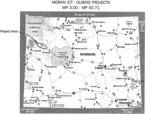
US-287/26 is a primary east-west route in northwest Wyoming that provides the most direct access to Grand Teton National Park and connects with north-south roadways that lead to Yellowstone National Park and the Jackson Hole area. The project area bisects Teton and Fremont counties and traverses the public lands of the Bridger-Teton National Forest, Shoshone National Forest, and Grand Teton National Park (see figure 1).
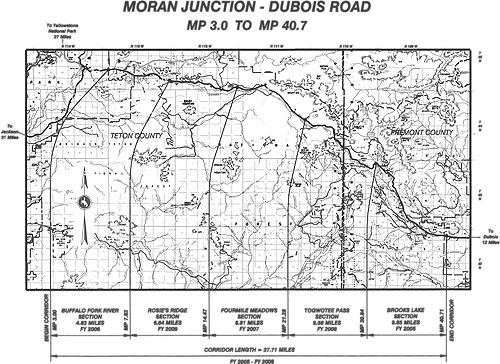
The Moran Junction-Dubois project corridor lies between MP (mile point) 3.00 and MP 40.71 on US-287/26. At the western end, the Buffalo Fork River segment of the project begins approximately 3 mi (5 km) east of Moran Junction. This point is 23 mi (37 km) northeast of Grand Teton National Park, 34 mi (55 km) northeast of Jackson, and 30 mi (48 km) southeast of Yellowstone National Park. At the eastern end, the Brooks Lake section ends at the Shoshone National Forest boundary, approximately 12 mi (19 km) northwest of Dubois. This point is 70 mi (113 km) northwest of the Wind River Indian Reservation, 86 mi (138 km) northwest of Riverton, and 88 mi (142 km) northwest of Lander (See figure 2).
Figure 2. Moran Junction-Dubois Project Corridor
The project corridor is part of the Centennial Scenic Byway, and is renowned for its natural, scenic, cultural, and ecological setting. US-287/26 also facilitates numerous outdoor recreational opportunities, including camping, hiking, snowmobiling, picnicking, hunting, and cross-country skiing. Local residents in Teton and Fremont counties use the road for year-round travel, and the road is also used as a truck route for goods to and from the Jackson area.
The U.S. Bureau of Public Roads constructed US-287/26 between 1955 and 1967. Portions of the roadway have been extensively repaired and reconstructed since that time. The existing roadway consists of two 12-ft (3.6-m) travelways with 0- to 2-ft (0- to 0.6-m) shoulders on the western 27 mi (43.5 km) and 7-ft (2.1 m) shoulders on the eastern 10 mi (16 km). This roadway corridor is situated at an altitude between 7,500 ft (2,286 m) to 9,700 ft (2,957 m) above sea level, with surrounding peaks of up to 10,900 ft (3,322 m) in elevation.
US-287/26 has substandard design features that do not meet current AASHTO recommendations, including numerous physical and operational problems that reduce the safety and capacity of the roadway and contribute to higher than average accident rates. These problems include poor sight distances, narrow or no shoulders, steep sideslopes, few turnouts, steep grades, sharp curves, deteriorating bridges, and geological hazard areas.
Traffic volumes are anticipated to increase over the next 20 years and are expected to contribute to congestion along the roadway, limit access to side roads and turnouts, and lower the quality of the driving experience. The purposes of the recommended improvements to US-287/26 are to improve safety, accommodate future traffic, correct design deficiencies, and improve visitor experience, while minimizing impacts to the natural and human environment and maintaining consistency with adopted Federal, State, and local plans.
2.2 Environmental Impact Statement
The Federal Environmental Impact Statement (EIS) was completed in October 2003. An interdisciplinary (ID) team comprised of various Federal, State, and local agencies was established at the beginning of the EIS process to assist with the development and evaluation of project alternatives. At that time, the 38-m (61 km) roadway corridor consisted of eight separate projects, which have since been reduced to five projects. The ID team considered seven action alternatives plus the no-action alternative, ultimately advancing four action alternatives along with the no-action alternative. A preferred alternative was eventually recommended for this project, meeting the objectives to increase safety, provide for future capacity, correct roadway deficiencies, and enhance visitor experience while also minimizing impacts to the natural and human environment.
The wildlife and fisheries impact analysis in the EIS identified the potential for impacts including loss of habitat, disturbance or displacement of wildlife, and the potential for increased roadkill. WYDOT and FHWA have since developed a 2-year wildlife movement study to identify major wildlife movement corridors within the project limits and to identify design and construction criteria that can be used to improve wildlife mobility within the roadway corridor. The study's development involved the cooperation of the U.S. Forest Service (USFS), U.S. Fish and Wildlife Service (USFWS,) and Wyoming Game and Fish Department (WGFD). This study was initiated in November 2003 and includes data collected by the USFS in 2002-2003. Wildlife movement studies will continue, as necessary, to ensure that current information is used to design each project.
2.3 Groups and Committees
The Socioeconomic Committee, composed of WYDOT and local community members, was created in September 2003 to discuss impacts to the Wind River area and to find ways to keep tourism in the area during the construction of the five projects. The major concern from local residents and businessmen was the time involved to construct five projects and the subsequent effect on the local businesses and tourism industry. From this committee was spawned the Marketing Group and the Constructibility Study Group. In March 2005, the Marketing Group completed a marketing plan to promote the accessibility of regional resources/activities during highway construction.
The Constructibility Study Group was formed in January 2004 to integrate construction knowledge and experience, along with citizen and USFS input, into the planning and preliminary concept development for the reconstruction of the corridor. It identified strategies to minimize impacts to the traveling public and adjacent communities while ensuring safety and the feasibility of construction. This was accomplished through the development of evaluation criteria and review of alternative time lines for completion of the projects; construction methods and design approaches used to minimize traffic disruption; and other methods to enhance the plans, specifications, and other contract documents for constructibility.
The Wildlife Steering Committee consists of members of the WGFD, the Greater Yellowstone Coalition, WYDOT, FHWA, and the USFS.
2.4 Design Considerations
2.4.1 Functional Classification
The AASHTO Green Book ("A Policy on Geometric Design of Highways and Streets," 2001) uses the concept of functional classification of highways to group types of highways according to the type of service they will provide. A complete, functionally-designed system provides a series of distinct travel movements. The movements can be described as the main movement, which consists of uninterrupted, high-speed flow with relatively long travel distances; a collection and distribution movement, which takes place on a lower-speed facility with the possibility of stops and shorter travel distances; and the last movement, which is a termination or land-access movement.
The Green Book defines three functional categories of streets and highways as arterial (main movement), collector (collection and distribution movement), and local (termination or access movement). Functionally, the systems change from total mobility associated with a high type arterial to total land access that is associated with a local facility. There are certain driver expectations associated with each type of functional classification.
US-287 between Dubois and Moran Junction is a National Highway System (NHS) highway, which is automatically classified as a Rural Principal Arterial-Other. Functionally, a principal arterial should accommodate high volumes of traffic and long distances at high speeds. Land access is secondary to mobility.
US-287 is also listed as a Wyoming Scenic Byway. By definition, scenic byways and backways are specially designated roadways that provide an opportunity for recreational or slower-paced travel through lands of significant or scenic or cultural interest.
The anticipated travel expectations of a motorist using this corridor as an arterial to quickly move from Dubois to Jackson is completely different from a motorist who is traveling slowly while enjoying the scenic value of the corridor. The different uses are at odds.
It has long been known that speed differential between vehicles can cause accident rates to increase. With the different motorist expectations, as well as a traffic mix that includes passenger cars, recreational vehicles, and trucks, it is possible to achieve speed differentials that can lead to higher than normal crash rates.
2.4.2 Design Consistency
A road should be designed in a manner that is consistent with the expectations of the user. Building a new highway with wider shoulders creates an expectancy in drivers that is consistent with high speed and long trips, and design features such as low-speed curves may not operate as well as desired.
While there are sections of this corridor that will provide design consistency, there are also other areas where the design speed, the operating speed, and the speed limit will be far enough apart to have the potential for problems.
2.4.3 Speed Limit
The current speed limit between Dubois and Moran Junction is 65 mi/h (104 km/h). Speed studies on tangent sections within the mountainous sections indicate that the 85 percentile speeds approach 70 mi/h (112 km/h). While the speed limit on the new project may be set lower than the existing speed limit, there is a high degree of probability that speeds will not be much lower, if any, than the speeds represented by current speed studies.
2.4.4 Multi-Use
Since this route is designated as an east-west bicycle route, it is desirable to have 8-ft (2.4-m) shoulders to accommodate the bicyclists.
2.4.5 Design Criteria
This roadway corridor contains several types of design deficiencies that contribute to unsafe conditions along the roadway. These include substandard shoulder widths; substandard curve geometrics; inadequate snow storage areas; substandard barriers and guardrails; motorist exposure to landslides; no provisions for bicyclists, snowmobilers, and pedestrians; reduced clear zones; and substandard passing and stopping sight distances.
Arterial highways are expected to provide a high degree of mobility. Therefore, they should be designed to provide high operating speeds with a high level of service. The AASHTO Green Book suggests that arterial highways be designed using a design speed of as high as 75 mi/h (120 km/h) on level terrain to a low of 40 mi/h (64 km/h) on mountainous roads. The appropriate level of service (LOS) for a principal arterial is B, with a lower value of C in mountainous terrain.
In general, it is desirable that the running speed of a large proportion of the drivers be at or below the design speed. Experience indicates that deviations from this desired goal are most problematic on sharp horizontal curves. While it is acceptable to design roadway features to a lower speed, it is desirable to maintain as high a design speed as practicable. This is extremely important on the US-26/287 corridor because of the mix in driver expectation as well as the vehicle mix. Maximizing sight distance (design speed) will provide the greatest margin of safety as vehicle speeds deviate. Using present standards, a design speed of 55 mi/h (88 km/h) was used to determine design deficiencies based on the following 2001 AASHTO design criteria:
- Horizontal curvature: a minimum radius of 1,065 ft (319 m) or 5.4-degree curve.
- Maximum superelevation (tilt of the roadway): 6 percent.
- Vertical curvature: stopping sight distance of 495 ft (148 m), passing sight distance of 1985 ft (595 m).
- Maximum grades: mountainous terrain 6 percent, rolling terrain 5 percent.
- Horizontal clearance from edge of travelway (clear zone): variable from 20-30 ft (6-9 m) for fills and 15-21 ft (4-6 m) for cuts.
- Lane widths: 12 ft (3.6 m).
- Shoulder widths: 8 ft (2.4 m).
2.4.6 Horizontal Alignment and Superelevation
The horizontal alignment of a roadway must provide a desired level of comfort for drivers traversing horizontal curves. The minimum curve radius is a limiting design value that provides the desired degree of comfort with respect to centrifugal force (the force attempting to push the vehicle to the outside of the curve) while drivers are traversing the horizontal curve at a given design speed. The minimum radius is determined by the maximum allowable rate of superelevation or tilt of the roadway, and the maximum allowable side friction factor relating to the friction between the tires and the pavement. WYDOT has established a maximum rate of superelevation of 0.06 (6 percent) for mountainous terrain, due to the relatively large winter snowfall resulting in snowpacked or icy highways.
The existing roadway has numerous substandard horizontal curves, based on minimum radii alone. Once existing superelevations are determined further into the design process, more curves might be found to contain deficient superelevation rates for the given degree of curve.
2.4.7 Vertical Alignment
The vertical alignment must provide adequate stopping sight distance. The available sight distance on a roadway should be sufficiently long to enable a vehicle traveling at or near the design speed to stop before reaching a stationary object in its path. In computing stopping sight distances, the height of the driver's eye (3.5 ft/1 m) and the height of the object to be seen by the driver (2.0 ft/0.6 m) are used. For sag vertical curves, the available sight distance is also dependent on the actual amount of roadway illuminated by the vehicle's headlights. The vertical alignment should also provide as much passing sight distance as practical.
The existing roadway has 14 vertical curves that do not meet the 55 mi/h (88 km/h) design criteria. The lengths and/or grades will need to be modified, or the curves totally reconstructed to bring the substandard curves up to current design standards.
2.4.8 Grades
The length and steepness of grades directly affect the operational characteristics of an arterial. AASHTO recommends that long grades on a mountainous rural arterial with a 55 mi/h (88 km/h) design speed be limited to 6 percent. If the length of a steep grade is such that the speed of a loaded truck will be reduced beyond a reasonable reduction in speed (15 mi/h, 24 km/h), design adjustments such as changes in location to reduce grades or addition of extra lanes should be considered.
2.4.9 Clear Zone
The term "clear zone" is used to designate the unobstructed, relatively flat area provided beyond the edge of the traveled way for the recovery of errant vehicles. The clear zone includes shoulders. Factors that affect the clear zone dimensions are design speed, embankment slope, traffic volumes, and degree of curvature of horizontal curves. The clear zone should be free of fixed object hazards and critical slopes. The 1996 AASHTO Roadside Design Guide recommends a variable clear zone of 20-30 ft (6-9 m) for fills and 15-21 ft (4-6 m) for cuts for slopes varying from 1:6 or flatter to 1:3. The steeper the clear zone slope, the longer the clear zone width. A slope steeper than 1:3 is considered a "critical" slope, on which an errant vehicle is likely to overturn, and is not an acceptable clear zone slope. A 1:3 to 1:4 slope is considered a "non-recoverable" slope, defined as one which is traversable, but from which most motorists will be unable to stop or to return to the roadway easily. A "recoverable" slope is an embankment slope 1:4 or flatter, and motorists who encroach on these can generally stop their vehicles or slow them enough to return to the roadway safely.
Most of the existing road consists of steep surfacing tapers due to the original construction plus numerous overlays. Most slopes beyond the surfacing tapers are steeper than 1:4. There is little opportunity for a vehicle to safely pull off the road for emergency reasons. The clear zone widths previously mentioned are by no means absolute. Any action that can be taken during design to increase the width of the recovery area will enhance the safety of the roadway.
2.4.10 Lane Width
The lane width of a roadway greatly influences the safety and comfort of driving, as well as LOS. The wider lane provides desirable clearances between large commercial vehicles traveling in opposite directions. The narrower lane forces drivers to operate their vehicles closer to each other laterally than they would normally desire. Lane widths for rural arterials may vary from 10-12 ft (3-3.6 m), but AASHTO recommends a 12-ft (3.6-m) lane width for a higher speed (>45 mi/h, 72 km/h), free-flowing, principal arterial. The existing lane widths are all 12-ft (3.6-m) wide; the proposed lane widths will also be 12-ft (3.6-m) wide.
2.4.11 Shoulder Width
A shoulder is the portion of the roadway contiguous with the traveled way that accommodates stopped vehicles, emergency use, bicycle use, and lateral support of subbase, base, and surface courses. The advantage of well-designed, properly maintained shoulders is providing space away from the traveled way for motorists to stop for emergencies, to change a flat tire, to consult a road map, to view wildlife or scenery, or to provide room for evasive maneuvers to avoid potential crashes or reduce their severity. Wider shoulders provide many benefits:
- Sight distance is improved in cut sections, thereby potentially improving safety.
- Lateral clearance is provided for signs and guardrails.
- Storm water can be discharged farther from the traveled way, and seepage adjacent to the traveled way can be minimized to reduce pavement breakup.
- Structural support is given to the pavement.
- Space is provided for pedestrian and bicycle use, for occasional encroachment of vehicles, and for detouring traffic during construction.
AASHTO recommends a minimum 8-ft (2.4-m) shoulder for rural arterials with projected traffic counts over 2,000 vehicles per day.
Environmental Concerns
2.5.1 Recreation
Wyoming Trails and the USFS estimate that 126 snowmobile-hauling vehicles are currently parking on the road. This is illegal and unsafe.
2.5.2 Socioeconomic
If a slide were to block the road east of the Flagstaff/Blackrock road intersection (MP 17.6), drivers would have to travel over South Pass to Pinedale to Jackson. This route would be roughly four times longer than that created by the Wolf Mountain Slide in the Snake River Canyon in 1997. If a slide were to occur west of the Flagstaff/Blackrock road intersection, that road could be used as a detour once crossings were reinforced to handle commercial vehicles. Likely the Blackrock Road does not have horizontal and vertical curves to accommodate two-way truck traffic.
2.6 Geotechnical Hazards and Impacts
The following sections explain in detail the geological conditions for the above road section.
2.6.1 Milepost 3.0 to 7.83 (Buffalo Fork River Section)
No major geologic hazards are present within this section.
The roadway traverses a flat section of highway along the Buffalo Fork River Valley. The geology of this section is predominantly composed of clay, silt, sand, gravel, and cobble alluvial deposits derived from the Buffalo Fork drainage. West of the Buffalo Fork River the roadway traverses glacial and colluvium material ranging from clay to boulders.
Stabilization of embankment foundations will be required along with some minor subgrade mitigation.
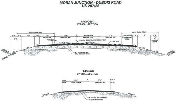
Figure 3. Moran Junction - DuBois Road US 287-26 Proposed and Typical Sections.
2.6.2 Milepost 7.83 to 14.47 (Rosie's Ridge Section)
The Rosie's Ridge section has the most geological hazards of any of the five sections on Togwotee Pass.
There is an elevation change of approximately 800 ft (240 m) with the roadway situated to the north of Blackrock Creek. The road traverses the Upper Cretaceous age Harebell Formation, which consists of interbedded shale, sandstone, and poorly cemented conglomerate. Between MP 9.5 and 12.0, the bedrock is covered with colluvium and glacial moraine material ranging in size from clay to boulders. The numerous springs within the permeable glacial soils act as a lubricant to activate slides randomly throughout this section.
There are approximately 13 slides within this section, of which about one-half are currently active. Road damage is common throughout this section. Slides include large circular and block failures and saturated debris and mud flows with the consistency of oatmeal. One very large slide located at MP 10.0 on Rosie's Ridge is approximately 2,000 ft (600 m) long x 700 ft (210 m) wide. Two large vertical 12-ft (3.6-m) diameter culvert drains were installed at this location in 1939, combined with horizontal drains that outlet onto slide debris below the roadway. Four construction projects were let between 1971 and 1998 to repair slides between MP 9.0 and 11.5. Repairs included realignment, lightweight fill (sawdust, wood chips), underdrains, geogrid reinforced fills, and a mudflow retention area.
Three cutslopes were assessed for rockfall risk potential by WYDOT; they ranged from low to very high.
Geotechnical problems are plentiful, particularly between MP 9.0 and 11.5. Many unstable slide areas and rock slopes are in need of urgent repair. Landslides and high groundwater conditions have created ongoing problems for maintenance forces and the WYDOT Geology Program.
2.6.3 Milepost 14.47-21.28 (Fourmile Meadows Section)
The Fourmile Meadows section has minor to moderate geotechnical problems.
The highway traverses a relatively flat, wide, tree-covered region in the west and then moves into a flat meadow section with typical hummocky topography associated with slides on the east end of the section. Geologic materials consist of clay, sand, and boulders derived from glacial moraine deposits. Bedrock in the eastern half of the section is the Tertiary Age Aycross Formation. It consists of interbedded claystone, siltstone, and tuffaceous sandstone. Covering the bedrock are colluvial and glacial deposits ranging from clay to boulder-size material.
There is a steel bin wall west of MP 21.0 that is at the toe of an active slide, which was placed to deter loose debris and slump material from entering the roadway. In addition, a slide at MP 20.2 that was repaired in 1985 with a sawdust lightweight fill is still active. Only one rock slope is within these limits, and it has a rating of low to moderate rockfall risk potential.
Geotechnical problems present include soft embankment foundations, frost heaves, soft subgrade, repair of several smaller landslides, and a rockslope.
2.6.4 Milepost 21.28-30.84 (Togwotee Pass Section)
The Togwotee Pass section has a minor to moderate level of geotechnical problems.
Bedrock in the western half of the section is the Eocene Wiggins Formation, which consists of volcanic breccia with a tuffaceous sandstone matrix. The bedrock weathers into rounded blocks and columns, creating rockfall hazards. Overlying the bedrock are glacial moraine and landslide deposits.
Bedrock in the eastern half of the section is the Tertiary age Aycross Formation that consists of weak layers of claystone and siltstone and strongly cemented and thick layers of tuffaceous sandstone. Overlying the bedrock is a thin covering of colluvial and glacial material.
Three landslides have been identified by WYDOT on this section; two of these are currently active. Repair work was done on these slides in 1971, 1985, and 1998, and consisted of underdrains and a sheet pile cut-off wall. Nine rock slopes have been rated on this section; they are rated from low to moderate risk potential for rockfall.
Predominant geotechnical problems on this section include necessary repair of at least three landslides and mitigation of approximately 5,500 ft (1,650 m) of rock backslopes. Since this is the highest section in elevation, frost heave problems within the roadway will have to be addressed. Retaining walls will be necessary to minimize encroachment into the Wind River.
2.6.5 Milepost 30.84-40.71 (Brooks Lake Section)
The Brooks Lake portion of roadway has many geological hazards similar to the problems on the Blackrock Creek Section.
This road corridor traverses the Wind River Valley along undulating terrain. Bedrock consists of interbedded shale, siltstone, and non-tuffaceous and tuffaceous sandstones of the Wind River and Aycross Formation that are generally weak and erodible. Landslide deposits cover most of the bedrock throughout this area. Also overlying bedrock randomly are clay, gravel, and cobble-size alluvial and glacial materials.
Approximately 12 landslides have been identified on this section, of which about half are very active and are currently affecting the roadway. Some of the slides are very large, extending up adjacent hillsides for 500 to 1,000 ft (150 to 300 m) and paralleling the roadway for stretches of up to 0.75 mi (1.2 km) each. The roadway has been repaired in many areas due to landslide-related problems. Numerous springs and in some cases, ponding of water, is present above and below the roadway. Repair work has been done on approximately eight of these slides between 1982 and 1998. Repairs include removal, woodchip fill, toe berms, drains, a combination "H" and sheet pile wall, and a geotextile wall. Only one slope has been evaluated for rockfall potential and it was rated in the low risk category.
The primary hazards on this section are unstable slopes. The current roadway design as recommended by the WYDOT Geology Program calls for shifting the alignment away from unstable backslopes for approximately 2.5 mi (4 km). This section will require repairs of four or five landslides, with one very large slide at MP 40.0 possibly costing several million dollars to stabilize. In addition to the landslide-related problems, it will be necessary to construct retaining walls and stabilize embankment foundations. Frost heave and soft subgrade problems will also have to be addressed.
2.6.6 Summary
Overall, the above geological hazards will require a variety of repair methods. For landslide mitigation these include, but are not limited to, toe berms, underdrains, retaining walls, lightweight fills, realignment, removal of slide debris, and tie-back anchors. Unstable rock slopes may require presplitting, flattening, meshing, rock bolting, shotcrete, and adequate ditch catchment sections. There are also a variety of subgrade problems within the roadway where geotextiles, subexcavation, and backfill with free draining material, underdrains, or other measures will be necessary to stabilize the sensitive soil and bedrock materials.
Due to the numerous amount of geologically-related problems, this highway corridor will benefit greatly from reconstruction. Many of the existing landslides have been worked on under various contracts since at least 1971; however, it appears that some of them continue to be a problem, often because some repairs were only temporary. Most of the rockslopes have been designed with inadequate catchment areas and poor blasting techniques and are a constant maintenance problem. The roadway has been patched and overlayed throughout the years by maintenance due to frost heave, soft subgrade, and other pavement- or subgrade-related problems.
With the use of modern highway design and construction techniques, many of these problems can be mitigated. Upgrading the road to current design standards will ultimately provide a safer road for the traveling public and reduce future WYDOT maintenance costs.
2.7 Maintenance
Maintenance costs have been evaluated for the two maintenance sections that are encompassed by the Moran Junction-Dubois reconstruction projects on US-26/287. Although the exact locations of problem areas are not available through the maintenance cost reports (i.e., Geneva), they have been discussed with the maintenance sections, the district maintenance engineer (DME), and the foreman for the Dubois crew.
The TE03A maintenance section runs from MP 2.20 to MP 26.75, and for all intents and purposes its costs can be totally included in the analysis. The FR03A maintenance section runs from MP 26.75 to MP 98.79, of which the area in question is from MP 26.75 to MP 40.71. The foreman and DME have both indicated that a majority of the surfacing maintenance (estimated at 70 percent), other than chip sealing, was done in the 14 mi (22 km) in question. Surfacing maintenance includes hand patching, motor grader patching, motor grader leveling, laydown operations, crack sealing, chip sealing, and base repair. The remaining maintenance costs were prorated on a direct-mileage comparison.
The crew foreman has indicated that even though surfacing maintenance costs are high, they are still not doing all that needs to be done. They have scaled back maintenance work over the past 2 or 3 years due to the upcoming projects in the State Transportation Improvement Plan. The slide areas are major causes for concern because of the possibility of the weight of additional plant mix increasing the potential for slides to occur.
Cost comparisons (on a per-mile basis averaged over the last 5 years), as shown below, indicate a substantial increase in the Moran Junction-Dubois maintenance sections when compared to similar roadways (mountainous terrain, traffic volumes, etc.) throughout the State.
Even with reduced maintenance efforts on the two sections in question, their average per-mile costs are significantly higher than all but one of the comparable sections. As the roadways deteriorate, these costs will only increase if the reconstruction projects are not continued.
2.7.1 Passing Lanes
To evaluate the need for passing lanes, Highway Capacity Manual software was used along with year 2025 predicted volumes. Percentage no-passing and traffic volumes are the critical factors in evaluating the LOS for the corridor. Twenty to 50 percent no-passing is normal on level terrain, and greater than 50 percent typical of mountainous terrain. The higher the percentage of no-passing zones, the lower the LOS. Levels of service are lettered from A to F with LOS A being the best and LOS F being the worst. The following are explanations for the levels of service.
- LOS A means average speeds are greater than 55 mi/h (88 km/h), passing demands are below capacity, drivers are delayed no more than 30 percent of the time, and almost no platoons of three or more vehicles are observed. The maximum service flow rate of 420 vehicles per hour (vph)-total flow in both directions-is not exceeded.
- LOS B is characterized by average speeds around 55 mi/h (88 km/h), passing demands are about equal to passing capacity, drivers experience delays 45 percent of the time, and platooning is becoming evident. The maximum service flow rate is a total in both directions of 750 vph.
- LOS C is typified by average speeds of 52 mi/h (83 km/h), increases in platoon formation and size, passing demand in excess of passing capacity, and delays 60 percent of the time. The maximum flow rate under ideal conditions is a two-way total of 1,200 vph.
- LOS D is approaching unstable traffic flow. Passing demand is high while passing capacity is approaching zero. Average platoon sizes are 5 to 10 vehicles and motorists are delayed 75 percent of the time. Turning movements and/or roadside distractions cause major shockwaves in the traffic stream. Average speeds can approach 50 mi/h (80 km/h) under ideal conditions, and the maximum two-way traffic flow is 1,800 vph.
- LOS E is unstable traffic flow. Any disturbance causes traffic flow to fail or fall to LOS F. The highest volume attainable under ideal conditions is a two-way total of 2,800 vph and is the capacity of the highway. Delays are over 75 percent, passing is impossible, and speeds vary from below 50 mi/h (80 km/h) down to 25 mi/h (40 km/h).
- LOS F is forced flow and is comparable to a slow-moving parking lot. Traffic flow has failed and the maximum flow rate is less than the roadway capacity.
The Moran Junction-Dubois road is classified as a principal arterial and is part of the NHS. It is the only direct connection from Dubois to Jackson or Yellowstone. The main purpose of the road is mobility-the safe, timely, and efficient movement of people and goods. The road also passes through a very scenic part of the State and thus carries tourists that are driving slower than the motorists using the road simply to get from point A to point B. The mix of motorists and variance in their speeds makes it imperative that a road design be implemented that will account for the different needs of motorists-through traffic as well as tourist and recreational traffic. The road must be designed for at least LOS C up to the design year, must accommodate slow traffic enjoying the scenery and wildlife, and must accommodate the normal traffic using the road mainly as a route connecting point A to point B.
Using year 2025 traffic volumes and the percent of no-passing zones for the evaluation of the Moran Junction-Dubois corridor yielded LOS B for the Buffalo Fork River Section from MP 3.01 to MP 7.50 and LOS D for the rest of the sections from MP 7.50 to MP 40.7. The Buffalo Fork River Section is relatively flat terrain and has good passing opportunities. The other sections are in steep mountainous terrain with few passing opportunities. The LOS D condition for the mountainous sections is unacceptable.
One of the most cost effective and least environmentally intrusive methods to achieve an efficient and safe two-lane road is to add passing lanes-one in each direction every 4 to 6 mi (6 to 10 km). Passing lanes allow faster moving motorists to safely pass slower moving tourists without getting impatient and trying ill-advised and unsafe passing maneuvers. To be effective, the lanes should be about 1 to 1.5 mi (1.6 to 2.4 km) in length.
Passing lanes added to two-lane highways have been found to reduce total crashes by 25 percent and fatal and injury crashes by 30 percent. For the Moran Junction-Dubois corridor, traffic recommends four passing areas for the LOS D sections. A passing area has a passing lane in each direction and the areas start at MP 11.6 and end at MP 40.6. The locations and lengths are as follows:
| Eastbound | Westbound | |
|---|---|---|
| Passing Area 1 | MP 11.6-MP 12.7 | MP 13.5-MP 14.8 |
| Passing Area 2 | MP 18.0-MP 19.3 | MP 21.6-MP 22.6 |
| Passing Area 3 | MP 27.3-MP 28.4 | MP 30.5-MP 31.8 |
| Passing Area 4 | MP 34.3-MP 35.3 | MP 39.4-MP 40.6 |
With the proposed passing areas and projected 2025 volumes, the roadway will operate at LOS C. Without the passing areas, the roadway will operate at LOS D.
2.7.2 Turn Lanes
Two lengthy left-turn lanes are recommended, a continuous two-way, left-turn lane for the KOA Campground and another continuous two-way, left-turn lane for The Cowboy Village resort. These are the only two areas that showed significant turn volumes. Other turn lanes may be recommended for safety or geometric reasons.
2.8 Structures
2.8.1 Structure No. BPH -Buffalo Fork River-MP 3.59
- Structure type: Four-span continuous concrete girder.
- Year built: 1954.
- Bridge roadway width = 26.2 ft (7.8 m).
- Structure length = 230 ft (69 m).
- Inventory rating: 24 tons. (A rating < 36 tons is considered substandard.)
- Structure condition:
- Deck has numerous cracks in asphalt surface and along bottom of deck.
- Concrete girders have vertical cracks.
- Abutments: Timber cribbing pushed out; signs of water leakage from deck.
- Condition state: Fair-structure will need major rehabilitation work to remain in service for an extended period of time.
- Sufficiency rating = 45.5.
- Recommended work: Bridge replacement due to age, condition, substandard load rating, and narrow width.
2.8.2 Structure No. BPI-Blackrock Creek-MP 8.44
- Structure type: Single-span concrete rigid frame.
- Year built: 1954.
- Bridge roadway width = 26.4 ft (7.9 m).
- Structure length = 83 ft (25 m).
- Inventory rating: 34 tons. (A rating < 36 tons is considered substandard.)
- Structure condition:
- Deck has numerous cracks in the asphalt surface.
- Wingwalls are tipped.
- Overall condition state: Adequate-structure may need major rehabilitation work to remain in service for an extended period of time.
- Sufficiency rating = 62.2.
- Recommended work: Bridge replacement due to age, narrow width, and substandard load rating.
2.8.3 Structure No. BXV-Brooks Lake Creek-MP 32.49
- Structure type: Double-barrel, 10 x 8 ft (3 x 2.4 m) reinforced concrete box culvert.
- Year built: 1961.
- Inventory rating: 36 tons. (A rating < 36 tons is considered substandard.)
- Structure condition:
- No deficiencies noted during annual inspection.
- Overall condition state: Excellent-structure can be expected to remain in service.
- Sufficiency Rating = 81.7.
- Recommend work: Extend culvert ends past clear zone.
2.9 Commitments and Constraints in the FEIS/Record of Decision
Note: Bold items are required by the Record of Decision. Other items are commitments to minimize harm.
The new roadway design is based on standards for rural, mountainous highways, reduced as necessary to minimize impacts to the natural environment.
Major alignment shifts-Limit major alignment shifts to those locations necessary to improve safety and avoid or minimize impacts to environmental resources.
Travel Lanes-Two continuous 12-ft (3.6-m) travel lanes are to be included in the design.
Shoulders-8-ft (2.4-m) continuous shoulders, 6 ft (1.8 m) in passing lanes, are to be included in the design.
Clear Zones-Use clear zones up to 20 ft (6 m) wide. Use modifications, as necessary, to minimize impacts to environmental resources or further improve roadway safety.
Passing Lanes-Locate passing lanes outside major wildlife movement areas. Refine the number, location, and length of passing lanes accordingly.
Wetlands-Avoid all fen wetlands.
Environmental Resources-Balance the following:
- Reduce ground disturbance with features such as guardrail and retaining walls to avoid or minimize impacts to environmental resources.
- Look for opportunities to improve wildlife movement, minimize retaining walls (number, length, and heights) and guardrail, and provide opportunities for wildlife to escape.
- Use flatter cut and fill slopes where needed to improve driver sight distance, and where possible to increase the success of revegetation.
- Identify locations where improvements to existing non-revegetated slopes and landslides beyond the cut and fill slope may be environmentally beneficial.
- Using wildlife study data, look for opportunities to improve wildlife crossings through things such as habitat and topography.
| << Previous | Contents | Next >> |