
In order to develop profiles of state-of-the-practice methods and potential advancements, the literature review and detailed bibliography that resulted were supplemented by the development of 11 case studies that centered on recent or ongoing studies being conducted at metropolitan planning organizations around the country. The main product generated from this effort was a 1-2 page summary of the context, application and possible improvements relevant to each case study shown in Appendix C (Case Study Summaries). The case studies are summarized in a table in Appendix C that describes the content and application of all the case studies, allowing a quick reference for those persons interested in finding a case with specific characteristics.
Several categories of agencies were identified at the outset of this study that might produce either direct information on the current practice of land use/emissions testing, or produce additional contacts. The major categories of agencies are:
Metropolitan Planning Organizations (MPOs). MPOs are responsible for conducting transportation conformity analysis and reporting according to federal law. They are also the primary agency responsible for considering the combined effects of transportation strategies over large, multi-jurisdictional areas, although parts of this responsibility may be shared. Regardless, the MPO is fully responsible under the provisions of 23 CFR Part 450 for transportation plans, programs, and projects, and in nonattainment and maintenance areas the provisions of 40 CFR Parts 51 and 93 to execute analyses and make a determination of the transportation conformity of its long-range transportation plan and transportation improvement program.
State/Federal Air Agencies. State environmental departments were not surveyed as a part of this study due to the fact these agencies have not traditionally taken a lead role in executing land use studies. It is recognized that these same agencies do assume a more significant review role for transportation conformity, and a direct role in evaluating TCMs for inclusion in the SIP.
Every regional office of the Environmental Protection Agency (EPA) was contacted during the course of the study. EPA staff were asked if they knew of any MPO, research agency, or state air quality agency that were conducting applied or theoretical research into the developing quantitative forecasts of emissions benefits from land use strategies. The EPA Regional Offices were also asked if any of these agencies had been a part of trying to get land use strategies included as a control measure in a State Implementation Plan (SIP). The Research Team discovered that in at least two instances, the Atlantic Steel and Woodlands case studies in this report, land use measures had been included in state SIPs (although the Atlantic Steel case did not take credit for emissions reductions). The discussions with EPA Regional Office staff were successful in identifying candidates for the case studies discussed in this report.
 |
|||
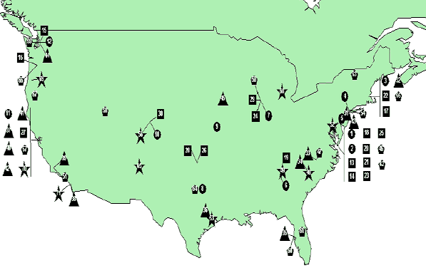
| Locations - US | Location of Primary Contacts in the United States and Worldwide |  |
|
 | Agencies | ||
 | Private/Semi-Private Organizations | ||
 | Universities and Research Institutions | ||
 | Metropolitan Planning Organizations | ||
 | Case Studies | ||
| Map No. | Organization Name* |
|---|---|
| 1 | EPA Clean Air Act Advisory Committee |
| 2 | Office of Policy and Economic Innovation |
| 3 | EPA Region 1 |
| 4 | EPA Region 2 |
| 5 | EPA Region 3 |
| 6 | EPA Region 4 |
| 7 | EPA Region 5 |
| 8 | EPA Region 6 |
| 9 | EPA Region 7 |
| 10 | EPA Region 8 |
| 11 | EPA Region 9 |
| 12 | EPA Region 10 |
| 13 | AASHTO |
| 14 | ITE, Transportation Planning Council |
| 15 | Global Telematics |
| 16 | Land Use, Transportation, and Air Quality (LATRAQ) |
| 17 | Caliper Corporation (TransCAD) |
| 18 | Smart Growth Network/Sustainable Communities Network |
| 19 | Center for Transportation Analysis |
| 20 | The Brookings Institute, Center on Urban and Metro |
| 21 | American Public Transit Association |
| 22 | Lincoln Institute of Land Policy |
| 23 | National Transportation Library |
| 24 | Travelmatters.org (Center for Neighborhood Tech) |
| 25 | The Assoc of State and Local Air Quality Agencies |
| 26 | Central Regional Air Planning Association |
| 27 | The California Air Pollution Control Officers Assn. |
| 28 | Central States Air Resource Agency |
| 29 | Conservation Design Forum |
| 30 | Rutgers University, Voorhees |
| 31 | MIT - Center for Transportation and Logistics |
| 32 | UNC-CH - Department of City and Regional Planning |
| 33 | UNC-Charlotte |
| 34 | USF - Center for Urban Transportation Research |
| 35 | Texas A&M University - Texas Transportation Inst |
| 36 | UC-Berkley, Institute of Transportation Studies |
| 37 | UC-Irvine, Institute of Transportation Studies |
| 38 | UCLA , Institute of Transportation Studies |
| 39 | UC-Davis, Dept of Environment, Science and Policy |
| 40 | San Jose State U, Mineta Transportation Institute |
| 41 | San Francisco League of Conservation Voters |
| 42 | Natural Resources Defences Council |
| 43 | University of Washington, (UrbanSim) |
| 44 | Iowa State University |
| 45 | Association of Metropolitan Planning Org. |
| 46 | Capital Area Metropolitan Planning Org. |
| 47 | Mecklenburg-Union Metropolitan Planning Org. |
| 48 | Atlanta Regional Commission |
| 49 | Chicago Area Transportation Study (CATS) |
| 50 | Southern California Association of Governments |
| 51 | Baltimore Metropolitan Council |
| 52 | Houston-Galveston Area Council |
| 53 | New York Metropolitan Transportation Council |
| 54 | Boston Metropolitan Transportation Council |
| 55 | Denver Regional Council of Governments |
| 56 | Metropolitan Transportation Commission |
| 57 | Washatch Front Regional Council |
| 58 | Puget Sound Regional Council |
| 59 | Hillsborough County Metropolitan Planning Org |
| 60 | Metroplan Orlando |
| 61 | Metropolitan Washington Council of Governments |
| 62 | Cittenden County Metropolitan Planning Org |
| 63 | North Central Texas Council of Governments |
| 64 | Mid-Region Council of Governments |
| 65 | Portland Metro |
| 66 | Rogue Valley COG |
| 67 | CommunityViz (Scenario 360 software) |
| 68 | Tri-County Planning Commission (Lansing, MI) |
| 69 | Lane Council of Governments (Eugene, OR) |
| 70 | Sacramento Area (SACOG) |
| 71 | San Diego Association of Governments (SANDAG) |
| 72 | TRANUS (Modelistica Systems and Planning) |
| 73 | Victoria Transport Policy Institute |
Research Institutions. These agencies were thought to be involved in the land use/emissions topic in at least two important ways: (1) assisting MPOs with technical problem-solving or data collection, management, or analysis; and (2) conducting independent research on specific, related issues.
Private, Quasi-Private, and Non-Profit Organizations. Although not a lead agent in conducting analysis, organizations that sold software for travel demand modeling, emissions analysis, and land use modeling were considered during this study. Quasi-private and non-profit or advocacy groups occasionally take a lead role in analysis, but more often provide the impetus for getting such studies programmed by other agencies, notably MPOs. The Research Team generally used these contacts to identify other agencies directly involved in the quantification of emissions benefits from land use strategies. The figure and table shown in Exhibits 4-1A and B provide a listing of those areas that were on the initial contact list and the physical locations of each. Although many agencies were deemed suitable for contacting for this research, some of the agencies were either not contacted after a second consideration of their potential contribution, or the agency was contacted but did not offer information that contributed to the objectives of this study.
One of the objectives of this study is to determine state-of-the-practice methods for quantifying the emissions benefits from land use planning strategies, it was necessary to define those aspects of various strategies that make them better or worse for future applications of end-user communities. A technical brief was developed that created categories of evaluation measures and tentative benchmarks that were used in the evaluation of the methods reviewed in the case studies. Exhibit 4-2 highlights the evaluation criteria that were used to assess various methods quantifying emissions benefits of land use strategies. Not shown are benchmarks developed for each evaluation criterion. Since these benchmarks were derived from published literature, they were deemed to be flexible and were used only as approximate guides during the course of the evaluation of various methods that were reviewed during the case studies.
The Research Team recognized that while the majority of efforts being undertaken concern regional scale assessments of large shifts to future land development, there were also relevant studies being conducted that consider the emissions benefits of local scale (neighborhood or community) analysis as well as some studies that went a step further and undertook dispersion modeling, potentially useful for small area or "hot-spot" analysis. For these two types or variants of study, the Research Team proposed adding or modifying a few of the evaluation measures to better accommodate the specific differences between them and the more common regional scale analyses.
The Research Team selected ten case studies from medium to large cities that had done prior work or were in the process of conducting studies evaluating the effect of land use policies on emissions. The case studies cover a range of complexity and technical difficulty. Based on the case studies the state-of-the-practice for this effort is to evaluate multiple set land uses and multiple transportation plans. Common practice appears to be to evaluate between two and five land use patterns along with several transportation scenarios. Seven of the eleven case studies in Appendix E evaluated either three or four land use scenarios. To some extent the transportation scenarios are adjusted to the land use pattern. For example, Lane COG varied the availability of express bus service depending upon the land use scenario being evaluated. The highest level of practice is found in those methodologies that include land use variables in trip generation and mode choice and use formal land use models to develop alternative development scenarios (sometimes termed "alternative futures").
Some local planners cited the desire of decision-makers to improve quality of life or to preserve open space. Others cited state planning regulations. The case studies also pointed out several things that would make this type of effort easier for them and others. These include more longitudinal data that establish effect of land use policies; better user interfaces for emission models1; travel models that are more sensitive to land use variables; simpler land use models that can predict the result of proposed land use policies; longer time horizons on regulatory emission models; and the need for accepted methodologies to evaluate the emission effects of land use changes.
| Criteria | Description |
|---|---|
| Portability | Does this method use data sources and models that are widely available to practitioners across the United States? This is a composite measure assessing both availability of datasets and use of standard computing equipment. |
| Data Requirements | A composite index describing detailed data input requirements or extensive manipulation of large data sets (e.g., post-processing of model outputs to get inputs for other models) to obtain reliable results. |
| Quantification | Does the method directly output criteria pollutant emissions in terms of tons or kilograms per time period, or is a secondary calculation/process required to reach these results? |
| Ease of Use | A composite index measure describing (a) the number of models required to be linked together to obtain reliable results; (b) special computing requirements; and (c) availability of interfaces, scripts or other scenario and data management tools. |
| Model Validity | A composite index measuring the validity of the results from the model or method. |
(Additional Criteria for Local Scale Analyses)
| Criteria | Description |
|---|---|
| Field Data Collection | Many neighborhood-level analyses require additional field data collection efforts on such items as design characteristics or street configurations. This measure complements the Tier One measure for Data Requirements. |
| Objectivity of Metrics | Do the metrics objectively assess accessibility and/or neighborhood form? In other words, will two analysts assess the same variable in the same way? |
(Additional/Modified Criteria for Dispersion Modeling)
| Criteria | Description |
|---|---|
| Need for Meteorological Data | Dispersion models typically require considerable additional data on wind speed/direction, humidity, ambient air temperatures, mixing conditions, sunlight, and so forth to conduct project-level, small area, or hot-spot analyses. This measure supplements the measure for Data Requirements for this type of effort. |
| Quantification | Does the method directly output criteria pollutant emissions in terms of tons or kilograms per time period, or is a secondary calculation required to reach these results? This measure replaces the Quantification criterion. |
Based on the case studies the Research Team believes it is feasible for many metropolitan planning organizations to evaluate multiple land use patterns. Making this effort will require dedicating both time and financial resources for a period of six months to two years for each application, depending on the complexity of the effort and the degree to which pre-existing models and data are already available to carry out the analyses.
Based upon the critical review of the literature, interviews and case studies described in this report, the Research Team compiled descriptions of both standard (state-of-the-practice) methods and advanced methods being undertaken to quantify the emissions benefits realized from land use strategies. The advanced method presents a number of refinements to the standard practice. These differences include: broader focus, more alternatives studied, more stakeholder involvement, more advanced land use and/or transportation models, and additional data collection efforts.
As diagrammed in Exhibit 4-3, the differences between standard and advanced methods start with the initial purpose of the study. The regulatory requirements of transportation conformity have created a de facto minimum standard of practice in this type of application. Where the project sponsor is focused on quantifying emissions for transportation conformity (i.e., regulatory) purposes, the methodology generally emphasizes components of standard, not enhanced, practice. Regions with more complicated issues add elements of the advanced practice depending upon their abilities and schedules. In a regulatory context time is often more important than either cost or performance as long as performance is adequate. In a non-regulatory context time is less important so the project manager can use additional time to gain better performance. The use of geographic information systems and gravity-based travel demand algorithms (either through a dedicated travel demand model or through an integrated land use-transportation model) are well-established and common to both standard and advanced practices. The basic steps for quantifying emissions benefits from land use changes are described on the following pages. It should be noted that in no instance was every advancement applied in a single case study; some advancements were present in several studies.
Standard |
Advanced | ||
|---|---|---|---|
| 0 | Determine Motivation for Quantifying Emissions Benefits of Land Use Strategies
|
|
|
| 1 | 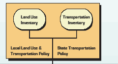 |
|
|
| 2 | 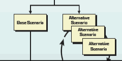 |
|
|
| 3 | 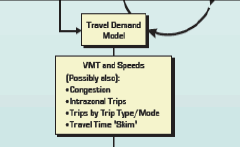 |
|
|
| 4 | 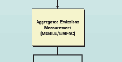 |
|
|
| 5 | 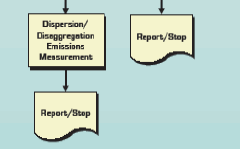 |
|
|
Pre-Analysis (Step "0" in Exhibit 4-3). The context within which the analysis will take place determines the goals and objectives of the study. These objectives, in combination with other factors such as available time, data, and financial resources; expertise; and the availability of pre-existing travel demand and land use models, drive the decisions about the tools and approach to be taken to quantify emissions benefits from land use strategies. The most important differentiating aspect of these studies is if the goal is to quantify the effects from community-scale, design-oriented causes or if the purpose is to look at regional-scale shifts of land use from one place to another. Both types of studies typically address density and mixing of land uses, but only the former considers the effects of design elements on mode split, trip frequency, and trip length.
Inventory of Land Use and Transportation Elements (Step 1). The prevalence of geographic information system (GIS) technology within state and local governments has greatly enabled the development, management, manipulation, and distribution of databases of land use types, environmental constraints on development and public infrastructure (e.g., transportation, schools, water/sewer). Again depending on the goals of the study, some or all of this information may be required for an analysis of land use and emissions. When design issues are under consideration, a fourth dataset is usually required that describes the specific characteristics of the proposed, existing, or surrounding communities that are to be studied.
| Land Use | Infrastructure | Environmental | Design Features |
|---|---|---|---|
| Slopes | Roads (by capacity or type) | Protected Habitat | Building Architecture |
| Existing Development | Transit | Floodplains | Street Layout |
| Historic Structures or Districts | Public Water and Sewer | Valuable Open Space or Recreational Areas | Landscape Architecture |
| Zoning Classification | Sidewalks | Wetlands | Street Design |
| Soils/Hydrology | Schools | Water Features | Edge Features |
Exhibit 4-4 provides examples of each of these data sets; but is not intended to be all-inclusive since literally dozens of variables have been used in various studies of land use and emissions benefits. The relevance of the first three columns of data types is oriented towards the constraints and inducements for growth; for example, areas that are environmentally sensitive or are expected to be served by public infrastructure. The fourth column in Exhibit 4-4 represents the general categories of information that are typically assessed for community-scale, design-oriented studies. The design category of data is critical in that it typically must be collected "in the field" since this information is seldom recorded in municipal databases and some of it is difficult to gather even from good-quality, digital aerial photographs. The implication for any community-scaled analysis is that there is usually a substantially greater amount of time and money required for data collection compared to regional-scale studies. Although not completely overcoming this problem, researchers that have undertaken design-based efforts have relied on (inexpensive) intern labor or sharply controlling the size of the study area(s) to offset the data collection requirements. The second implication of data constraints on design-based studies is that these studies are nearly impossible to conduct for a time-series analysis since historical data records are not kept for detailed design features (this is a difficult problem faced in regional studies as well, but not to the same degree). Without historical data, understanding a cause-and-effect relationship between design elements and travel behavior/emissions is extremely problematic. Additional information is required for the travel demand and emissions models, which are explained in subsequent steps.
Development of Land Use Scenarios (Step 2). The second step of the modeling process for quantifying the emissions benefits from land use strategies involves the creation of the land use scenarios that will be tested. This should involve one baseline case developed from expectations of past trends continuing into the future. This is not a "Do Nothing" case; rather, the baseline case assumes similar growth rates, growth patterns, policies, and infrastructure development for the study area in similar quantities and at a similar pace as seen in the past. The MPO draws the infrastructure improvements from the long-range transportation plan which in turn is developed from proposals put forward by MPO members. Population and employment growth, location, and type are derived from existing projections, comprehensive plans, small area land use plans, U.S. Census, and state demographers. Since the baseline scenario is seen as the most probable future for an area, as well as being represented in documents that help guide economic growth, the baseline forecast of land use and transportation information is usually adopted by a policy board such as a metropolitan planning organization (MPO) or Council of Governments (COG). Transportation conformity rules stipulate that a transportation conformity analysis must include the "latest available data." It is important that there be no subsequent forecasts of planning data made by, or for the MPO. It also seems advisable for the MPO to verify the accuracy of land use forecasts as part of the planning process.
Once the baseline case has been adopted, one or more alternative land use scenarios are developed. The alternatives may have greater densities of development; more provisions for transit, bicycling or walking modes of travel; more diversity of complementary land uses in close proximity; or a design that facilitates trip-making by a means other than private automobile. Typically, shifting growth in housing and employment from one area to another is a "zero-sum game" with respect to the entire study area. There should be no net loss or gain of people or jobs between the alternative scenarios and baseline scenarios. Market forces that cause large numbers of people or jobs to relocate to other regions are generally assumed to be beyond the scope of these studies and beyond the ability of state and local governments to control. However, the changes in land use represented by each alternative future typically represents some policy directive, such as better balancing of jobs and housing (diversity) or a proposed zoning practice incorporating design-based codes.
While large, well-funded planning organizations often use formal land use models these tools are not often accessible to smaller MPOs. Two less costly tools available to these MPOs are the expert panel and the Delphi techniques.
The expert panel process is a structured, face-to-face interview or facilitated meeting involving local experts on land-use and growth. The panel can be structured as a facilitated work session that allows for full interaction between the various experts. Likely candidates for the expert panel include, but are not limited to, school officials, utility providers, real estate professionals, environmental groups, parks and recreation professionals. The purpose of the panel is to elicit the group's best opinion about the amount and location of growth in the region.
The Delphi technique is similar to an expert panel with two key differences. First, the panel members do not meet face-to-face and, ideally, should be anonymous to one another. Second, the process is iterative with panel members responding to a number of questionnaires intended to converge on the 'most likely' future.
Travel Demand Modeling (Step 3). A complete discussion of travel demand modeling is beyond the scope of this research. There are numerous documents providing guidance on each step of the travel demand modeling process. The Research Team recognizes that there is significant variability between urban areas regarding the level of effort and detail used in their modeling effort. While there are efforts to apply new methods or more precise model formulations to predicting travel, four-step models are the current state-of-the-practice and will be the focus of this discussion.
The traditional four-step modeling paradigm processes land use (or socio-economic) data and transportation network data through four related, but separate, sub-models to arrive at an estimate of travel that is generally expressed in terms of person trips, vehicle trips, and vehicle miles of travel. In addition to these performance measures travel models can provide estimates of mode split, travel under congested conditions, travel speed, and intrazonal travel. While there is no regulatory requirement to 'post-process' model network speeds, the analyst should not use the travel model's estimate of speed for three reasons. First, many travel models are at least partially validated by adjusting link speeds to shift traffic from place to place; in other terms, travel demand models are calibrated to link volumes, not link speeds. Second, the link speed actually represents the difficulty of moving (impedance) along that link of the network. Third, the network information encoded in travel demand model networks has traditionally been inadequate to accurately estimate link speeds. For example, delays incurred as a result of signal delays, recurring congestion, and accidents are seldom reflected in travel demand models. Some limitations can be partially overcome by using either a link type volume-to-speed lookup table or a link type post-processor to estimate realistic travel speeds.
Most trip generation modules use cross-classification models that estimate trips based on two or more dimensions of a trip generation matrix. Commonly used variables include household size, automobile ownership, and household income. Some cities, for example Baltimore, Maryland, have experimented with adding land use variables to their trip generation modules. The Research Team believes that this is feasible and good practice, but that it requires a substantial additional effort and resources to locally collect additional land use and travel behavior data.
Trip distribution most often uses a version of the gravity model to distribute trips between origin and destination zones based on the size of the attraction and the perceived travel time between the two points. A key point in the trip distribution process is that the gravity model should be iterated using congested travel times until travel times do not change between trip distribution and trip assignment. 40 CFR Part 93.122(b)(1)(iv) and (v) and a number of other documents strongly encourage iterating between the gravity model and trip assignment. Of interest is the suggestion from the Denver Regional Council of Governments (DRCOG) that modelers should carefully consider their techniques for balancing productions with attractions. DRCOG staff believe that by balancing to productions for home-based trip types that modelers may be losing some of the effect of land use strategies. One alternative is to modify the trip generation equations to respect linkages between several different land use types for both the origin and destination ends of each internal trip within the model.
For mode choice the current state-of-the-practice is the multinomial logit model. These models assign trips to modes based on the availability of that mode in both origin and destination zones and the relative utility of that mode to other modes. It seems likely that to fully account for land use effects in travel demand models that both walking and bicycling modes should be included as well as various transit modes, and that the mode choice model should include a term accounting for either land use or local network design. A note of caution is that it is difficult to effectively evaluate the effect of land use changes on transportation without a predictive mode choice sub-model, and many existing travel demand models in use today have deterministic mode choice sub-models.
The current state-of-practice in trip assignment is to use a capacity sensitive assignment algorithm. There are a number of assignment options that meet this criteria including equilibrium assignment, stochastic equilibrium assignment, and incremental assignment methods. The Research Team believes that capacity sensitive algorithms will remain the standard for some time to come.
The next step of the process is estimating emissions based on travel and speed. As discussed earlier, link speeds should be post-processed based on link characteristics. The state-of-the-practice is to estimate an average speed by facility type and estimate emissions based on that speed and the motor vehicle fleet characteristics associated with a given facility type. The reason for the aggregation is the excessive computing time that would be entailed for estimating emissions for each network link.
Aggregated Emissions Measurement (Step 4). In a conformity analysis, or other regulatory analysis, the emission factors will be calculated based upon the most recent EPA-approved mobile source emissions model (MOBILE6.22 as of this writing) and the AP-42 guidance for determining emission factors. An emission factor is a quantitative amount of pollutant emitted by vehicles for every mile the vehicles travel or every hour the vehicles idle. The engine factors that would affect MOBILE6.2 emission estimates include vehicle model, type, age, fuel used, driving patterns, roadway types and conditions (freeway, arterial, collector, local, and ramp), temperature, humidity, technology, and regulations (vehicle emission standards, fuel standards, Inspection and Maintenance programs, etc). With all examined inputs for input engine data, as well as traffic conditions such as traffic speed, cold/hot start percentages, and others, the emission factors will be estimated as output of MOBILE6.2. It is important to note here that VMT and speeds, by facility type, represent the key data inputs that originate from travel demand models. Travel models are also sources for information on trip origins and destinations which can be used to estimate starts and evaporative emissions. Any effect that can be measured by a travel demand model but is not actuated through one of these two data inputs will not be "sensed" by the emissions model. The roadway emission strength can then be estimated by multiplying VMT and traffic volumes to these emission factors to determine source strength on each of the traffic links within the study region, or, more commonly, on aggregations of VMTs reported by roadway grouping or classification. The link-based method may be more responsive to local scale applications than aggregating to a larger geography, but this largely depends on how the emission factors are assigned to individual links in the travel model network.
The combined results and sum of air emissions resulting from all analyzed roadway links within the study area will constitute a basis of conformity determination for this region that has regional concern for CO, PM, or ozone and its precursors - VOC and NOx. Regional analysis of these emissions and effects must be assessed and reported in the TIP or long-range transportation plan conformity determination report, depending upon the nature of the exercise.
Disaggregated Emissions Measurement (Step 5). Often, it is desirable to consider the local scale dispersion effects of a land use change. As noted elsewhere, localized density increases may reflect positively in a regional land use scenario, but increases in local VMT may actually worsen both congestion and air quality in the vicinity of the density increase. In this case, the MOBILE model procedure described above may not be completely adequate3. Furthermore, the location of receptors may be moved closer to the edge of the roadway by suggesting a more New Urbanist set of design codes. This particular downside of enhanced design attributes has not been explored in the literature review conducted for this project. The CALROADS suite of dispersion models and one alternative model are described below that typically accommodate dispersion analysis.
CAL3QHC. This is a model derived from the original CALINE3 model with additional queuing and hot spot calculations. Both CALINE3 and CAL3QHC model are designed to determine air pollution concentrations at receptors downwind of emission sources by using a steady-state Gaussian dispersion. CAL3QHC estimates total air pollutant concentrations (CO or PM) near highways and arterial streets due to emissions from both free-flow moving and idling vehicles, as well as the length of queues formed idling vehicles at signalized intersections. While this model takes into account the expected emissions, roadway geometry, and meteorology, the model also reflects the fact that land use characterization also plays an important role in air dispersion modeling. These land use factors will affect the meteorological conditions processing to define air dispersion situation such as urban or rural conditions, wind direction, as well as surface roughness length (which is the measure of height of obstacles in the study area) against wind flow. This land use effect on downwind dispersion, known as washing, is a function of various land uses such as water surface, forest, swamp, cultivated land, grassland, suburban, urban, or center city land use types. CAL3QHC is a simple model for Tier 1 analysis in most areas without traffic congestion. Compared to other models, it provides conservative (highest prediction of concentrations) results.
CAL3QHCR. CAL3QHCR is an enhanced version of CAL3QHC. It is capable of processing up to a year of meteorological, vehicle emissions, traffic volume, and signalization data for each hour of the week in one run using the same basic dispersion algorithms from CAL3QHC. Daily or seasonal runs can also be made. Output from the model consists of calculated running eight-hour and one-hour averaged CO or 24-hour and annual block averaged PM-10 concentrations. CAL3QHCR is a much more robust and complicated model that can be used for areas with traffic congestion and potential to exceed NAAQS. It would usually provide a more realistic prediction of air pollutant concentrations by using hourly meteorological and traffic emission data. The prediction can be as low as 40% of that predicted by CAL3QHC due to the procedural refinements available in CAL3QHCR.
CALINE4. CALINE4 predicts air concentrations of carbon monoxide (CO) and particulates (PM), as well as concentrations of nitrogen dioxide (NO2) near roadways - an advanced procedure due to various settling velocities for gases and particles. In addition to roadway and intersections, it can also model parking lots, depressed freeways and canyons. Currently, it is used only in California. CALINE4 can predict various pollutants including NO2 in addition to CO and PM, and for various facilities such as parking lots, street canyon areas, etc. in addition to areas near roadways and intersections.
BREEZE ROADS (Alternative). BREEZE ROADS can be used to predict the ground-level concentrations of CO, PM, NO2, VOC, and benzene (not a CAA criteria pollutant, but recognized as an airborne toxin by the model) from the roadways and development. This model has been approved by U.S. EPA and includes the CAL3QHC, CAL3QHCR, and CALINE4 line source dispersion models as well as a traffic algorithm for estimating vehicular queue lengths at signalized intersections. BREEZE ROADS will estimate the total air pollution concentrations from both free-flow moving and idling vehicles. This model incorporates three modules: two for modeling a single hour specific meteorological data condition (as defined in CAL3QHC and CALINE4), and the third for modeling hourly meteorological data and mixing height algorithm (as defined in CAL3QHCR). In addition, the BREEZE ROADS model also incorporates an accounting of NO to NO2 conversion. This dispersion model can be used in conjunction with emission factor models such as MOBILE or EMFAC. It also includes a fully integrated GIS database.
1 There are two issues relating to MOBILE's user interface. First, MOBILE still operates as a command line or batch file interface, no longer state-of-the-practice for production software. Second, the analyst must do a considerable amount of reformatting inputs and outputs before using MOBILE and before moving to the next analytical step.
2 The regulatory model for California is the EMFAC/Burden series.
3 Although it should be noted that at least one travel demand model can report emissions to a fine (1km) grid or to traffic analysis zones using a subroutine that "calls" MOBILE for every grid cell in the overlay.

