
The final task undertaken by the Research Team was to recommend directions for further research and assistance to agencies that will be conducting analyses to quantify emissions benefits from land use strategies in the future. These recommendations were based upon the critical reviews of the literature and contacts with end-user communities discussed in this report. The improvements emphasize methods that produce results usable for State Implementation Plans (SIP) and conformity analyses. However, other end-users that are motivated by improving aspects of quality of life (economic, cultural, etc.) bring additional techniques not commonly represented by those agencies wishing to conduct an analysis as part of a conformity determination, particularly in the areas of land use planning and economic development. Therefore, this second group of end-users should be recognized as a partner that can enhance technical practices.
The first section of this chapter discusses the user community profiles, differentiating levels of resources and specific needs of each community of end-users by the tools and methods required to create a credible forecast of emissions changes from alternative land use strategies. The second section of the chapter identifies specific shortcomings of current state-of-the-practice methods and points to improvements that would be beneficial to the quantification of emissions benefits, developing land use strategies, and travel demand modeling. The third and final section discusses how to make training, techniques, and data more accessible to all of the end-user communities.
During the course of research, several different communities of end-users were identified. Understanding these different communities and their needs is a necessary first step to creating a context that allows an accurate assessment of research needs and how to improve the skill sets within the user communities (both of which are discussed in subsequent sections).
Metropolitan Planning Organizations. MPOs are clearly the largest potential community of agencies that have a direct interest in the quantification of emissions benefits from alternative land use strategies. MPOs that are either nonattainment or maintenance for one or more of the NAAQS are responsible for proving that their transportation plans, programs, and projects conform to the intent of their state's SIP. They also participate with the air agencies to develop transportation measures to reduce emissions. Less than half of all MPOs are operated within the same organizational framework as Councils of Government (COGs) which, like the MPO, are frequently engaged in inter-jurisdictional studies of best land use practices, environmental effects of development and related issues. The specific needs of this end-user community include improving skill sets of staff; accommodating study approaches to meet the restrictions imposed by (frequently) small staffs and budgets; and ongoing technology transfers as methodological improvements are made.
State and Local Air Agencies. Usually contained within the state's environmental department, the state air quality or emissions staff works cooperatively with metropolitan planning organizations, state departments of transportation, and private contractors to develop emissions testing methods, review emissions tests, and create state implementation plans and control strategies to reduce emissions. These agencies typically do not lead efforts to apply land use-emissions, but are often involved and interested in such studies when they touch upon SIP development or conformity issues. The needs of this group tend to be more aligned with understanding the theory and methodological strengths of various approaches to quantifying emissions benefits from land use strategies. This would allow a more complete review capability when MPOs and other agencies propose using land use as a means to reduce mobile source emissions.
Regional Air Agencies exist in many areas and play a similar role to that of state air agencies. Their interests are similar to those of the state air agency but their focus tends to be on permitting and enforcement of SIP rules addressing measures to achieve transportation conformity.
Private Sector. Large private developments, such as the Atlantic Steel case study shown in this report, may undergo emissions analyses under certain circumstances (e.g., to get TCM status for some component, to obtain CMAQ funding for a critical piece of infrastructure, or to comply with state or local permitting regulations). These agencies typically want to tout the benefits of their development scenario over another scenario, and want to obtain government permissions and permits required to construct a planned development or project. Therefore, the private sector consulting firms conducting these studies tend to be primarily interested in seeing an adopted set of broadly recognized standards for calculating emissions benefits from proposed developments.
Transit Planning Agencies. This subset of users typically includes those agencies that are assessing or promoting transit-oriented development solutions that complement existing or proposed high-quality transit services, usually rail. Although sometimes their interests in land use/emissions benefits studies are expressed through the appropriate metropolitan planning organization, these agencies are frequently capable of conducting detailed and robust studies using their own resources. The current policy of the Federal Transit Authority not to consider possible changes to ridership forecasts based on land use changes that may result from having increased access to the transit service in New Starts applications has perhaps dampened the market for such studies by transit agencies. Initial feasibility studies are still conducted to help justify some of the benefits of transit development that may be conferred on local, municipal partners. The interest of these agencies is focused on considering the interrelationship between improved transit service and the supporting role that "smart growth" and denser, mixed use land patterns can offer to transit station areas. These studies, and the transit agencies' interests, tend towards considering the design features of small (1/4-mile and 3/4-mile radius circles) study areas and their impacts on mode choice. Increasing the understanding of design effects on travel behavior are desirable, as are the emissions benefits and costs of higher-density living, shopping, and working arrangements.
Federal Agencies. The Environmental Protection Agency (EPA) and USDOT (particularly Federal Highway Administration and Federal Transit Administration) support research in the areas of land use and mobile source emissions, and are often present at interagency consultation meetings to discuss conformity practices undertaken by MPOs. Like state air quality agencies, federal agencies are often placed in a role of reviewer and resource agency to the lead agency conducting a study of land use/mobile emissions, at least when the results of such a study may be cited during a conformity determination process. Further, FHWA and FTA must make independent conformity determinations based in large part upon the information provided to them by the MPO. Hence their interests are also related to understanding the theoretical underpinnings and communicating acceptable best practices to those agencies that wish to undertake such studies.
Advocacy Groups. This community of end-users may include formal, informal, publicly or privately subsidized groups that have a direct or indirect interest in the subject of air quality benefits from land use changes. Part of the interests of the Congress for New Urbanism (CNU), for example, resides in the health benefits to communities that exhibit smart growth patterns of development over traditional, more sprawling patterns of development. Groups like the Sierra Club may have a more direct interest through a role as "watchdog" or motivator for land use studies. Segments of the public may briefly coalesce to support or protest certain proposed developments, plans or programs based on their emissions benefits or costs. Varied in their level of expertise, the primary need of these groups is reliable information that is readily absorbed by people that may never actually conduct any portion of a land use/mobile emissions study. Increasing the level of expertise of these groups is nevertheless important, since the awareness that these groups possess may provide an important long-term influence on the quality and quantity of land use/emissions studies that are conducted.
Based upon an understanding of the needs of various end-user communities, discussions with case study participants, and a critical review of past studies and research, the Research Team proposes a three-pronged approach to improving the current state-of-the-practice in quantifying emissions benefits from land use strategies: improving the management of land use and transportation inventories and forecasting; modifications to travel demand models; and modifications to emissions modeling. Each of these is discussed below, with specific recommendations for both research and application improvements under each of the three main headings.
Tools for Managing Large Data Sets. For regional-scale studies where large numbers of traffic analysis zones and/or large numbers of attributes are involved, the management of data for multiple scenarios becomes a significant problem. In a number of studies reviewed, the primary tool for manipulating large data sets of zones and zonal attributes was a series of computerized spreadsheets. The Research Team recommends that more emphasis be placed on both optimizing the capabilities of spreadsheets through Visual Basic applications (VBA) and built-in functionality, as well as migrating the data to geographic information system (GIS) platforms. VBA is a programming environment that allows repetitive tasks to be performed quickly, or that allows tasks not normally a part of the feature set of the spreadsheet software. Built-in VBA functions such as pivot tables, application "wizards," and database queries can be of assistance in error-checking and applying control totals to long columns of data. VBA code, once developed, is readily exported to other users conducting similar work; hence, a VBA code library may be useful to the end-user communities that are taking a lead role in conducting such work.
Tools for Forecasting Growth and Development Scenarios. In recent years, there has been a proliferation of GIS-based models that allow the consideration of a number of variables (see Exhibit 4-4, for example) to forecast land use scenarios according to pre-defined policy parameters. In many conformity-based land use/mobile emissions studies, there is an initial assumption that land use will be aggregated or "mixed" according to some supposed concept of reasonableness based on changing past trends through undefined or poorly defined policy actions. If an alternative land use scenario is selected as the preferred alternative, then the lead agency must then embark on developing and assessing policies and programs to effect the presumed land use changes. Beginning with a calibrated land use model that is sensitive to policy and environmental changes as well as past development trends can provide the ability to create a larger number of trial scenarios very quickly and also permits sensitivity testing, indirect impact assessments, community impact assessments, and cost-benefit assessments. These and other reasonableness tests can greatly aid agencies involved in interagency consultation meetings, for example, to have some additional degree of confidence that the postulated land use changes will actually happen if certain policy directives are undertaken by local and state governments. As an added benefit, land use models often integrate with standard travel demand models and GIS packages, allowing faster modeling of multiple scenarios and display of results to decision-makers.
A promising recent development in the area of dynamic land and transportation modeling is the use of cellular automata. Popularized by John Conway and his Game of Life1, the central concept of cellular automation is that each cell in a grid obeys certain rules according to its own (internal) condition as well as to influences of the other cells around it (externalities). A number of land use models are using cellular automation to help predict when a sub-area (cell) becomes "active" or develops. Physical constraints, public infrastructure supply, ownership, and zoning are typical examples of internal properties of each cell; the state and type of development of adjacent cells are considered externalities. Much like Dr. Conway's original Game of Life, the models assess the current state of all cells to determine the state of each cell in the next iteration of the model. Extremely complex interactions and regularized processes can develop from very simple rules applied in this manner. It has been proposed that the application of cellular automation models can help reduce the amount of data required for a model since each iteration builds off of a base case and a simple set of rules to determine each successive iteration. These models also offer the opportunity to test multiple scenarios under different rules very quickly without the manual adjustment of many individual cells (or traffic analysis zones) and the ability to integrate economic and non-economic constraints/incentives fairly easily. There are problems associated with these models, particularly the issue of efficiently calibrating them to known conditions. While this can be accomplished to some degree using spatial autocorrelation techniques to relate known or historical conditions to modeled conditions, pinpointing the adjustments required to improve a model's ability to emulate known conditions is made difficult by the complexity of the interactions among so many discrete entities represented by cells and their internal/external variables.2, 3
In order to hasten the adoption of land use models, greater attention needs to be applied to developing usable, detailed data sets and expanding the expertise of the end-user communities while simultaneously lowering the learning curve required to create and use these models. Creating partnerships between the various end-user communities can often help offset the considerable financial and staff time resources required to create and maintain land use models. One case study participant noted that a greater emphasis on economics-based land use models would be desirable. Many land use models rely solely on past development trends and physical constraints to create future land use scenarios, not market trends.
Creation and Maintenance of Appropriate Data Inventories. Design-based alternative scenarios, as already mentioned, face a particular challenge in field data collection since design aspects of areas are seldom maintained in usable formats. Developing standards for defining mixed use, street layout configurations, street designs, transit service, pedestrian/bicycle amenities and other independent variables would aid local agencies in knowing what information to collect and maintain. Another aspect of this problem is defining and understanding the real effects of adjacent land uses that are not supportive of travel behavior changes on those areas that do exhibit some features that might alter mode splits, travel behavior, or trip lengths. Additional research needs to be conducted to help understand these boundary and edge effects. Similarly, the size and composition of geographic analysis units (e.g., traffic analysis zones) also play into the considerations of how to store and maintain spatial data, requiring additional cooperation between agencies that traditionally may have little pre-project interaction with each other on visionary projects, such as GIS, transportation, and planning departments.
A number of possible improvements or research topics were revealed speaking to case study participants, as well as during the review of the technical literature from research efforts.
Manipulation of Intrazonal Trips. Those trips in the model that do not reach the edge of their originating zone are called intrazonal trips. It is the stated purpose of many regional and community-scale land use/emissions modeling efforts to maximize intrazonal trips, since this implies that a greater percentage of trips are shorter or are made by walking and bicycling. Typically, some fraction of intrazonal trips are assumed to be walk, bike, and car trips. The percentage of each trip type is sometimes determined by an index created from land use characteristics of the zone. Many travel modeling packages do not assign intrazonal trips to the regional network so additional steps may be needed to estimate the VMT associated with intrazonal trips. Many of the travel interactions necessary to evaluate the effect of land use changes on emissions occur in the intrazonal trips. It is therefore very important to obtain estimates of intrazonal trips for use in transportation conformity, and generally when evaluating the emission effects of land use changes. Very often intrazonal VMT is taken to be some percentage of total VMT that is estimated based on the number of intrazonal trips or is estimated using the number of intrazonal trips multiplied by 1/2 of the average distance between adjacent zones.
The conformity regulation notes that "Reasonable methods shall be used to estimate nonattainment or maintenance area VMT on off-network roadways within the urban planning area. . ." Travel modelers have taken three approaches to this task: (1) assuming that local VMT is some percentage of total VMT and adding this percentage to the local VMT, (2) treating centroid connector VMT as local VMT, or (3) estimating local VMT by multiplying the number of intrazonal trips by an averaged length such as 1/2 of the average distance to some number of the nearest zones.
However, a number of factors can influence the number of intrazonal trips: number of productions/attractions occurring within the same zone (mixture of uses), centroid connector speeds, size of the zone and size of adjacent zones (since intrazonal trips are in part determined by the distance to the centroid of one or more neighboring zones), and friction factors applied in the model. Modifying any of these variables will have some affect on the number of intrazonal trips, and the effect may be significant if the study area is small or the change to the variable is applied globally throughout the model. For example, increasing the link speed on centroid connectors increases the number of trips that reach the edge of the zone, thereby decreasing the number of intrazonal trips.
Zone Composition and Size. The size of the traffic analysis zone has traditionally been determined by the amount of development (jobs and housing) within the zone; efforts are made to keep this number fairly consistent across the model, implying that zone areas increase as population and employment densities decrease. Furthermore, it is traditional practice in model development to minimize the number of land uses within a single zone. However, many alternative land use strategies require the mixing of land uses in close proximity to one another, hence conflicting with the homogeneity of zones. Again, the size of the zone will affect the number of intrazonal trips that are made, and potentially cloud any small changes in travel behavior that may occur due to design features of the community. Just as travel models are not calibrated to link speeds, zone boundaries are not selected based on the homogeneity of design features or street layouts. This means that the very zonal structure of travel demand models is ill-suited in many cases for examining the relationship between land use and travel behavior effects that might influence mobile source emissions. Splitting large zones; changing zone boundaries; reconsidering centroid connector placements and speeds; and reevaluating intrazonal travel times are recommended practice for most applications. Additional research detailing zone modifications that better reflect land use strategies is an identified need.
Design Feature Sensitivity. Measuring and assessing the impacts of design values in an existing or proposed community as part of a land use scenario has proved to be a significant topic in the past, since the evaluation of some of these features tend to be subjective. Developing a consistent evaluation method for design features that relates to mode choice and vehicle miles of travel would be a significant contribution to the existing literature. Some studies have focused on this aspect of the land use/travel behavior relationship, but a consistent evaluation method has not emerged. Once a consistent method for measuring the complimentary design features of a community has been established, additional research and case studies that apply the methodology to a variety of communities and settings would greatly enhance the ability of the model to accurately reflect changes to trip generation and mode choice due to community design.
Technical Improvements in Modeling Framework. Bicycle and walk mode modeling is still in a very early stage of development compared to roadway and transit modeling. Calibrating to what is often a very small number of trips made by bicycling or walking; adding network attributes (or a separate network entirely); and developing trip generation/attraction models have generally not been within the resource or capability constraints of many agencies developing travel demand models. However, many of the benefits that accrue to denser, and design-friendly communities primarily benefit these modes of travel. It is quite possible, for example, that pursuing a gravity-based formulation for these trips is not as good an approach as considering an activity-based model. A greater understanding of what makes these modes more attractive, how trips are generated, and mode choice decisions would be beneficial to overall travel demand modeling practice. Another approach, already in use in some modeling applications, is the use of a land use index that modifies the trip generation or mode choice sub-models to account for greater numbers of biking and walking trips in those areas that have design characteristics favorable to those modes of travel. Simplifying and standardizing these indices would be an important improvement to current practice.
Tour-based modeling and activity-based modeling structures are relatively recent additions to the traditional four-step modeling process, which has been substantially unchanged for the past three decades. In tour-based modeling, information is retained about the trip-maker throughout his/her day, meaning that if a person gets to work by bus they are not likely to go home in their personal automobile. The Travel Modeling Improvement Program (TMIP) has allowed great strides to be made in the application of highly disaggregated travel demand modeling. Activity-based modeling makes assumptions about trip-making behavior not on the characteristics of the trips, but on the profile of the trip-maker. This approach inherently offers some advantages to replicating those local scale, land use elements of the decision-making process that current four-step models may overlook.4 Both modeling techniques are still in a relative stage of infancy, but do show some promise for the application of emissions benefits since they require a more disaggregated dataset and more understanding of the trip-maker.
Travel behavior surveys, usually conducted through a diary format for a random or stratified-random sample of trip-makers, can be improved greatly to help better define the impacts of land use. Seldom are these surveys stratified by land use characteristics. Instead they are stratified (or the sample is expanded for certain stratifications) by income or car ownership. A better accounting of the type of community that each survey respondent resides or works within can greatly enhance the understanding of how community type can influence travel behavior and thus emissions. A second improvement to travel behavior surveys would be scheduling frequent, even annual, survey sampling rather than conducting very large samples at much less frequent periods. This would allow for a better representation of the longitudinal data relationships than is currently the normal practice. A better understanding of the elasticity relationships and critical thresholds that influence travel behavior (and emissions) based on land use changes may be the single most important line of research that can be pursued in the short-term. Additional cross-sectional and longitudinal studies should be accumulated to help define the elastic relationship between the independent variables of community design, development intensity, and land use diversity to the dependent variables of mode choice, vehicle miles of travel, and trip lengths. The Research Team suggests that elasticities alone cannot adequately explain these relationships; there are thresholds above or below which no significant change in travel behavior occurs and hence no emissions benefits accrue. Hence, these elasticity-based analyses should not be used for conformity purposes, but remain in the realm of a first tier assessment of the potential of a proposed land use strategy to generate emission benefits.
Exhibit 5-1. Elasticity-Only and Elasticity Threshold Relationship
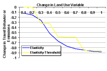
Exhibit 5-1 illustrates an elasticity-only relationship to a land use change and a curve that reflects both elasticities and thresholds. The implication of the elasticity-threshold curve is that small changes in land use patterns do not produce small results in emissions - they may produce no results whatsoever. Only when a critical threshold or large increment of change is achieved does the actual travel behavior and emissions within a region alter in response. This is especially true at either end of the elastic region of the curves, and can be intuited by considering the case of changing a residential land use from a R-40 (one dwelling unit per 40,000 square feet) to a R-20 designation (one dwelling unit per 20,000 square feet). By itself, this doubling of density is unlikely to achieve any results in mode choice, trip lengths or any other travel behavior likely to impact emissions. Both land designations can still be low-density, suburban neighborhoods reliant on the private auto to reach all destinations. Visually, they would appear very much alike, with both cases characterized by driveways, attached garages, many cul-de-sac streets, and homogeneous land uses. The extreme opposite end of the spectrum may also be true: those communities that are already at a very high development density may not exhibit marked changes in transit use, trip length or other travel behavior variable if density is increased further.
This example also highlights a second issue confronting researchers: many changes in travel behavior and the resulting emissions benefits require changes in multiple variables. A doubling of land use density by itself may be a very small component of realizing travel behavior changes in a community, but if land uses are more diverse, designs in streets and building orientations are more walk-friendly, and high-quality transit service is implemented nearby there is a much better chance of realizing significant travel behavior changes. Many studies have attempted explicitly or implicitly to disentangle the effects of various land and infrastructure changes. The Research Team proposes that the whole land use-travel behavior construct may be considerably greater than the sum of its individual parts. The implication is that land use variables are codependent and cannot be isolated during analysis, raising additional questions about the ability of traditional four-step models to "capture" the effects of multiple land use changes.
A better understanding of the land use-travel behavior relationship is the most productive path both to developing a sketch analysis tool for smaller MPOs to conduct feasibility testing for including land use strategies in their long-range plans, and for reviewing agencies to test the reasonableness of proposed changes' potential benefits to air quality. The current understanding of this relationship is presented in Appendix D. Additional research that adopts consistent study methodologies can be used to fill in the gaps in the current understanding of the land use-travel-emissions relationship.
Exhibit 5-2. Ranges of Percent Change from Case Studies
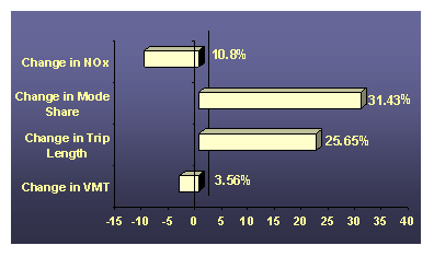
Exhibit 5-2 uses data from the case studies to illustrate the magnitude of the changes that cities have reported in practice. The figure shows the percent of change associated with NOx, mode share, trip length, and vehicle miles of travel. Unfortunately, the case studies did not report the density changes in a manner that is compatible with evaluating the other changes in terms of elasticity. Also notice that the change in VMT is relatively small when compared to the changes in trip length and mode share. For mode share this is in part due to the generally small mode share of modes other than driving. It should also be noted that while the range of change for NOx is 10.8% this includes both increases in NOx and decreases in NOx.
Making changes to emissions estimations has traditionally been the responsibility of the USEPA, although input from MPOs and state air agencies has been provided to each new version of the MOBILE model. USEPA certifies modeling programs after extensive testing and comment periods. Hence, if a land use-emissions study is being conducted for conformity purposes, the MOBILE model (or EMFAC in California) is the tool that must be used to create emission factors. These factors are then applied aggregately to vehicle miles of travel to produce an emissions forecast. Some disaggregation is possible either by grouping links by type or classification, or by attributing the emission factors to links in the travel model network.
There are some well-known shortfalls to current emissions models that, either alone or in conjunction with a travel demand model, particularly affect the estimation of mobile sources due to land use changes. For example, the grid street pattern and narrow street widths preferred in many smart growth initiatives are often hypothesized to affect vehicular speeds in the research. If the travel demand model link attributes do not respect these differences as compared to other local, subdivision streets, then the VMTs on these grid streets may be subject to inappropriate speed/capacity constraints or be entirely ignored by the classification system used to aggregate the VMTs. This problem is (usually) easily remedied by adding one or more classification types to the appropriate network attribute, although collecting information on these street systems to a level necessary to differentiate a grid street systems' effects on VMT may be quite onerous for a small planning agency.
A second issue is the lack of appropriate information about acceleration events that may occur in a neotraditional, grid-like street pattern. The MOBILE model is sensitive primarily to speeds, not acceleration events, even though these events have been shown to make a disproportionate contribution to emissions for many trips and vehicle classifications5. Microsimulation modeling for small-scale studies as a post-processing step may be used to help overcome this particular shortfall, if the simulation captures vehicles (by type) during periods in which they are accelerating. Again, this a demanding amount of additional work over and above the work already put into land use and travel demand models.
A third issue is the refinement of the zone system in the travel demand model and how intrazonal trips are treated in the emissions analysis. The modeler must ask the question if there are trips that are being lost that should have shown up on the network, and if the intrazonal trip lengths are reflective of what is actually happening. The best way to overcome these problems is by having smaller zone sizes - again, this implies considerably more effort to develop demographic data and placing centroids and connectors for each zone that is split.
A final improvement that is taking place is the need for an improvement in the data input and data output capabilities of the MOBILE model. Currently, MOBILE is run as a batch file using line code; outputs are presented in many sheets of tabular information. Increasing link groups or scenarios greatly increases the magnitude of the output. At least one third-party vendor has produced software that interfaces with MOBILE to make data entry easier and displaying output more user-friendly. Additional products that perform the same function in the GIS and travel demand modeling realms is a desirable trend.
Although additional research is necessary to advance technical methods, the Research Team identified several other shortcomings in the dissemination and availability of techniques that must be addressed to make good practice available to more MPOs wishing to measure the emissions benefits from land use strategies. The four main categories of assistance are in training for staff, acknowledging data requirements to carry out various kinds of analyses, improving technical tools, and disseminating information through a consolidated community of end-users.
The Research Team estimates that less than 10% of all MPOs have ever attempted to conduct a detailed land use-emissions study. Several barriers, including resource and time constraints, were noted within a number of small- and medium-sized MPOs. Training staff within the MPOs about data requirements, available methods, and realistic estimates of resources to conduct these analyses are needed. Making this report and other documentation available in a readily-absorbed format, conducting training workshops at major transportation conferences (notably, Transportation Research Board and Association of Metropolitan Planning Organizations), and providing information through the Internet are recommended strategies that would reach metropolitan planning organizations.
The quantification of emissions benefits from land use strategies requires three types of information: land use, transportation (sometimes these two are integrated) and emissions. These models may not be complex affairs relying on dedicated software, but nevertheless fit the definition of a model as a simplification of reality. Each of these models requires significant amounts of data about the natural environment of the study area, sociodemographic characteristics, and vehicle information. Information is required to be in a specific format, and may require historical or detailed field data to calibrate properly. A menu of approaches should be developed that (1) provides an understood level of "robustness" as a trade-off in data requirements; and (2) is clear with respect to data input requirements for each method. This would allow a direct comparison of the needs of the analysis and data available to the agency conducting the study. Additional attention can be paid to local and federal data collection efforts, such as Census and PUMS (Public Use Micro Sample) datasets, to ensure that these products improve the data that is collected in a way that is meaningful to land use-emissions research (e.g., car ownership, trip behavior, lifecycle information).
At least three models are required to conduct a quantification of emissions benefits from land use actions: land use, travel and emissions. Most of these models, depending on the vendor, are free or at relatively low-cost: land use models are generally less than $2,500/site, and the required emissions factor model in 49 states, MOBILE, is free. One exception is with travel demand modeling. While there are packages such as QRSII© that are fairly low-cost, the most common models charge $5,000 - $10,000 per site with an annual maintenance fee that is hundreds of dollars. The cost of a GIS usually has to be added to the cost of a land use model, since the latter often runs in concert with the former (or at least requires data to be manipulated in such a way that a GIS is almost a necessity). The most popular GIS package costs about $2,500/site plus an annual maintenance fee. The barriers to dissemination of appropriate technical methods and lack of technical support have also been deterrents to using more advanced tools.
A second clear need is for a sketch analysis tool based on estimated relationships between land use, travel behavior and emissions. As previously mentioned the data, skill sets, time, and financing are generally beyond the capability of many MPOs and other end-user communities. One interviewee suggested that less than 20 MPOs (out of about 350) have actually participated in a robust, quantifiable land use-transportation study. There would seem to be a strong benefit to developing a spreadsheet tool that has the following characteristics:
Incorporates the elasticity-threshold concept that can be modified based on user inputs;
Accounts for design features as well as land use shifts in density and diversity of uses;
Applies default or most recently available emissions factors, and
Accommodates sensitivity testing, presents a range of error values, and presents the outputs in tabular and graphical forms.
By applying this tool early in the feasibility stage of a long-range transportation planning effort, a community can gauge the degree to which land use strategies can realistically help them meet transportation conformity goals. A brief user's guide that explains the tool, its limitations, advanced procedures, and policy guidance could be developed to accompany the spreadsheet tool. Both products could be made available over the Internet.
Many studies that are conducted are never properly documented, or the documentation that is generated is never distributed beyond the immediate set of stakeholders. At a minimum, the following guidelines should be adhered to whenever a land use-emissions benefit study is conducted:
Sponsoring agency and contact information;
Date of study initiation and completion;
Data input requirements;
Financial, computing, and staffing requirements;
Model parameters, software, and calibration information for every model and sub-model; and
Outputs from analysis, including the results of any sensitivity testing.
Particular attention should be paid to those requirements that mesh with those of the Environmental Protection Agency for agencies wishing to receive SIP credits. The USEPA has published guidance information about the documentation requirements of agencies wanting to claim emissions reductions due to proposed land use changes6,7. The USEPA reports preview some of the findings discussed in this report, and also identifies a number of areas that EPA can support to get more MPOs involved in, and better at, producing emissions-land use studies:
Identify the effectiveness of urban policies at redirecting growth patterns;
Increasing cooperation among "balkanized" local governments;
Facilitating developer actions to produce lower-emissions developments through the use of the Smart Growth Network and other opportunities; and
Using the expertise contained in the regional EPA offices to assist local, MPO staff in the quantification of emissions benefits from land use strategies.
Housing documentation in an Internet-based format can provide the basis for disseminating case studies to interested parties, regardless of the end-user community to which they belong. A central repository should be designated to aid in the distribution of case studies. Each case should be indexed by indicators describing its ease of use/resource requirements, purpose, and geographic scale of the study area. This would allow the potential end-user to select those studies that are of the greatest potential benefit to their own situation.
1 Gardner, Martin. On cellular automata, self-reproduction, the Garden of Eden and the game 'Life.' Scientific American 224, No. 2 (February, 1971): 112-117.
2 D.P. Ward, A.T. Murray, and S.R. Phinn. An optimized cellular automata approach for sustainable urban development in rapidly urbanizing regions. Department of Geographical Sciences and Planning, University of Queensland, Brisbane, Australia. Proceedings of the 4th International Conference on Geocomputation (1999). See also (www.geovista.psu.edu/sites/geocomp99/Gc99/025/gc_025.htm) for a reprint of this paper.
3 There are many available references and demonstrations of both Conway's Game of Life and cellular automation applications. Included on the accompanying CD-ROM are Clarke, et al's seminal 1997 work proposing a modeling construct for the San Francisco Bay area which serves as a good introduction to the topic. The authors also recommend reviewing the SLEUTH model as an example of a refinement of the Clarke urban growth model that uses cellular automation coupled with Monte Carlo simulation as a working land use model that has been tested in several major metropolitan areas (www.ncgia.ucsb.edu/projects/gig/project_gig.htm).
4 RDC, Inc., Activity-Based Modeling System for Travel Demand Forecasting, Sponsored by Metropolitan Washington COG, USDOT, USEPA. September, 1995.
5 Christopher Frey, PhD, et al, "Emissions Reduction Through Better Traffic Management: An Empirical Evaluation Based Upon On-Road Measurements," North Carolina State University, 2001.
6 USEPA, Background Information for Land Use SIP Policy, EPA Report No. EPA420-R-98-012. September 30, 1998.
7 USEPA, EPA Guidance: Improving Air Quality Through Land Use Activities, EPA Report No. EPA420-R-01-001. January, 2001.

