
The first task of the study was to collect, review and summarize relevant literature that has been produced regarding land use and emissions benefits. The Research Team did not limit the literature search solely to those items that contained information documenting a process that went from land use change to travel behavior change to mobile source emissions change; rather, literature that helped describe either of the two primary linkages (land use to travel behavior or travel behavior to mobile source emissions) was considered valuable for the purposes of this study.
The following sections describe the sources, review methods, and findings from these studies.
The project work plan identified numerous potential sources of literature for the detailed bibliography exercise. These resources initially included all of the following:
Transportation Research Information Services (TRIS);
International Transport Research Documentation (ITRD);
Victoria Transport Policy Institute (VTPI);
The Brookings Institution;
American Planning Association/American Institute of Certified Planners (APA/AICP);
American Association of State Highway Officials (AASHTO);
Association of Metropolitan Planning Organizations (AMPO);
American Public Transportation Association (APTA); and
Universities with strong backgrounds in transportation planning and land use interactions.
In all, 46 papers were reviewed for this project. Once each technical paper or report was obtained, citations shown in these reports were added to the candidate list of literature items. By repeating this procedure with each new literature item and list of references, the Research Team was able to compile a thorough database of research papers dealing with the topics of emissions and travel behavior changes resulting from land use strategies. The Research Team was able to chart its progress by noting how many duplicate citations that they encountered with each new, additional research paper. Although a compilation of literature items was provided to FHWA early in the life of the study, the Research Team continued to add to its database as new literature items were discovered throughout the course of this project. In all, 46 literature items were critically reviewed, evaluated and summarized according to the procedure described in the next two sections.
During the course of the literature review, there were four distinct research tracks identified. Each track is characterized by different hypotheses, and, to some degree, by the technical capacity of the agencies conducting the study.
Health and Human Environment. The general premise of this research consists of attempts to relate the built environment to human health. A typical hypothesis of this strain of research examined the effects that higher density, mixed-use developments had on the propensity of people to walk more than would be the case in a low-density, homogenous suburban environment. Lower body weight, decreased incidence of cardiopulmonary disorders, and other health benefits were typically cited as the dependent variables in these studies.
Transit-Oriented Development. As the name suggests, transit-oriented development is focused on encouraging people to make more use of transit through compatible neighborhood designs, typically centered on commuter or light rail terminals. A typical area of exploration for this type of research is to determine a minimum threshold of housing units/acre above which mode share significantly tilts toward the use of transportation other than single occupant, private automobiles.
New Urbanist Design. The New Urbanism is a term often used by those in the architecture and urban land planning fields to describe ways of accommodating mixed-use and pedestrian-friendly activities in close proximity. The Congress of New Urbanism (CNU) states in a section of their charter:
Many activities of daily living should occur within walking distance, allowing independence to those who do not drive, especially the elderly and the young. Interconnected networks of streets should be designed to encourage walking, reduce the number and length of automobile trips, and conserve energy. (CNU, 2004, website: www.cnu.org)
This is done by assuming common building designs, relaxing restrictive zoning standards, changing street setback standards, requiring rear lot vehicle access, and adapting street cross-sections to slow vehicular traffic while accommodating pedestrian and bicycle travel. Often, these community designs call to older, pre-World War II neighborhoods that were situated on rectilinear street systems and serviced (initially) by a trolley or other transit system. These studies typically attempt to compare two or more neighborhoods with different design features.
Travel Demand Modeling. The fourth research track is that of achieving improvements to travel demand modeling methods. Most often, these studies focus on the generation of trips and mode choice, and are enhanced by the presence of statistically robust travel behavior surveys, or diaries. Using these surveys allows considerably more control over some of the variables that cross-correlate with other common independent variables that plague the other three tracks of research, particularly household income and auto ownership. On very rare occasions a metropolitan planning organization responsible for conducting travel behavior surveys develops a regular schedule for surveying. The resulting historical profile of travel behavior would be one of the single largest improvements to the land use-travel behavior linkage, since a historical comparison would be able to make a much stronger statement about cause-and-effect relationships than the cross-sectional studies that have dominated the field on this subject.
Synthesis Studies. Although not described as a separate category, a fifth literature area has emerged which seeks to synthesize and explain a broad cross-section of past research. Notable are the following three works:
Apogee/Haigler-Bailly, 1998, The Effects of Urban Form on Travel and Emissions: A Review and Synthesis of the Literature. This was an unpublished draft completed for the Environmental Protection Agency. The authors concluded that while there had been sufficiently robust research to determine and quantify effects on travel behavior from land use strategies, elasticities should be avoided in favor of setting thresholds where these changes are likely to occur. This synthesis comes the closest in terms of content and function to the current critical review of the literature, but many of the highest-quality studies have occurred after its release.
Reid Ewing and Robert Cervero, 2001, Travel and the Built Environment - Synthesis. This report picks up where the Apogee/Haigler-Bailly work leaves off by proposing elasticities for the effects of land use strategies on travel behavior. To do this, the authors compiled past research that had significantly (probability less than or equal to 0.05 of systematic error) proven relationships between certain land use strategies and trip frequencies, trip lengths, mode split and VMT. These elasticities were additive, and hence could be combined to form a composite measure from multiple strategies.
Kuzmyak, J. Richard; Pratt, Richard H.; Douglas, Bruce G.; Spielberg, Frank, 2003, Land Use and Site Design - Chapter 15 of TCRP Report 95, Traveler Response to Transportation System Changes. This work supports the land use strategy/travel behavior models noted earlier, particularly the effects of density on lowered vehicle miles of travel. The report does note that these effects do not occur in a vacuum and that other, supporting characteristics are important to the overall results. Another chapter (Chapter 17 of TCRP Report 95) will be released in 2004 that discusses transit-oriented development in a similar manner, but was not available for review at the time of this writing.
The project workplan expressly called for a database management system to store all of literature items, based on the recognition that sorting and assimilating information from many studies gathered over a period of months would make the task of distilling their contents problematic. Another reason for creating a database as opposed to a more traditional "flat-file" format in a word processor was that each literature item was to be rated on various factors that described the item's usefulness to the project goals. The Research Team described each literature item based upon rating factors using a one-to-five scale with one being the lowest utility and five being the highest (the score was left blank where the variable did not apply to the particular literature item). These variables described the research's handling of internal/external factors influencing outcomes; the validity of the research approach; how transferable the research is to other areas; if and how the research handled air quality/emissions; and the data requirements for the methodology. (See Appendix B for a complete description of the variables and assessments.)
By scoring each paper, it was possible to prioritize each research effort by various areas of emphasis. Although no attempt was made to assess inter-rater reliability (the degree to which two or more reviewers may interpret the same information differently), each paper was reviewed twice by different people to add validity to the reviews. The scores were averaged and commentary merged to form a single record of the review. The complete record layout is shown in Exhibit 3-1. The results of this work culminated in a detailed, critical review of the literature as called for in the project work plan.
| Field Identification | Description of Field |
|---|---|
| Title | Title of the article |
| Date of Publication | Date of accepted publication |
| Type of Work | Case study; synthesis; research |
| Author(s) | Principal and secondary authors |
| Author Contact Information | Address, telephone, email address of principal (first-listed) author. Where contact information was incomplete but readily available from another source, this was used instead. |
| Input Geography | Geographic units used in analysis |
| Data Inputs | Data inputs used in analysis |
| Output Geography | Geographic units for output |
| Data Outputs | Data outputs presented in analysis |
| Exogenous/Endogenous Variables |
Measurement on 0-5 scale. (See description in Appendix B for details on the definitions of each measure.) |
| Validity | |
| Portability | |
| Air Quality | |
| Data Needs | |
| Cost-Benefit | |
| Description of Project | Commentary on contents and conclusions in the article. |
The case studies provide a window on the state-of-the-practice with respect to modeling the effect of land use changes on travel and emissions. The case studies show some patterns in driving forces that motivated the studies and analytical methods used to carry them out. The cases are drawn from medium to large urban areas and the techniques are meaningful as guideposts on how to estimate the types of travel and emission changes that might occur if certain land use policies are implemented within a metropolitan area. Interestingly, it is not only governments which have embarked upon these studies: the private sector is a lead partner in two of the 11 cases.
Originally, the Research Team hypothesized that the motivator for all of these studies would be an attempt to comply with the regulatory framework imposed by the Clean Air Act Amendments of 1990. As information was collected, it became clear that there were at least two motivators for undertaking this type of work. First, the regional planning organizations generally embarked upon comparative studies linking land use and transportation in the quest of more livable communities. The regional scale case studies are essentially visionary attempts at quantifying propositions to improve livability or quality of life. When livability is the motivator, emissions, transit use, and congested travel serve as measures of the livability of a community. Second, the private sector has been motivated by the desire to do well by doing good. Their focus has been at the sub-regional or corridor level of scale. These studies are more likely to be undertaken in order to work within the regulatory framework of the Clean Air Act.
The Case Study Selection Matrix Exhibit 3-2 is intended to assist the reader in selecting the case study most useful in a specific situation. Each case study evaluation criterion is discussed briefly below.
Scale - is the scale for which the analysis was performed. This factor is intended to give end-users some indication of whether or not this particular case study matches the scale of analysis in which they are interested. There are case studies at three scales: site specific, corridor, and regional level. Note that there is some upward overlap between the scales so that a site scale analysis may include elements of corridor or regional analyses.
Level of Practice - is an indicator of how the case study compares to the others in its application of tools. The level of practice is characterized as fair, good, and best. It should be noted here that no individual method is automatically acceptable in any future application, and that the goals of these case studies may influence the choice of approach in other, future applications.
Credit Received - indicates whether or not the project sponsor received formal emissions credit in either a state implementation plan or from the congestion mitigation air quality program.
Key Player - shows the driving party of the case study. While the key player may not have done most of the work, they are the entity that is creating the desire to move forward with the study.
| Scale | Level of Practice | Credit Received | Key Player | Strengths | Case Study Name |
|---|---|---|---|---|---|
| Site | Fair | TCM in GA SIP (no emissions credit taken) | Private Sector | Proved Lower Emissions Over Conventional Development | Atlantic Steel (Atlanta, GA) |
| Region | Good | None | MPO | Technically Strong | Baltimore Metropolitan Council |
| Region | Better | None | MPO | Technically Strong, Land Use Model | DRCOG (Denver, CO) |
| Region | Fair | None | MPO | Model for Entry-Level Practice | Mid-Region Council of Governments (Albuquerque, NM) |
| Region | Good | None | MPO | Evaluates Multiple Land and Transportation Plans | Lane COG (Eugene, Or) |
| Corridor | Fair | None | MPO | Recognized and Mitigated Local VMT Increases | MUMPO (Charlotte, NC) |
| Region | Good | None | MPO | Public Participation, Land Use Planning | SACOG (Sacramento, CA) |
| Region | Good | Conformity | MPO | Done through LRTP Conformity Process | SANDAG (San Diego, CA) |
| Region | Good | None | MPO | Public Participation, Land Use Planning | Tri-County Planning Commission (Lansing, MI) |
| Site | Fair | SIP/CMAQ | Private Sector | Proved Lower Emissions Over Conventional Development | Woodlands Town Center (Houston-Galveston, TX) |
From the technical perspective the case studies fit into three categories that we have labeled fair practice, good practice, and better practice. We have explicitly avoided the term best practice for two reasons. First, no case study exemplified all the characteristics of what the Research Team would call best practice and second the state-of-the-practice is rapidly changing. Compounding factors in our decision not to define a 'best practice' include the resource intensity required at all levels of the practice, and the difficulty of transferring current methods from area to area.
Better Practice includes a number of features not found in the lower levels. First, it is the technically most advanced level of practice. It normally includes from three to five land use scenarios and as many transportation plans. It also includes both a formal (computerized) land use model and an advanced travel demand model. In addition to the technical models the stakeholder component of the land use and transportation planning process is very strong. Often there are a number of committees for stakeholders that are very involved in the evaluating land use and transportation. In addition the stakeholder involvement processes work at multiple governmental levels (e.g., regional, county, and town). Unfortunately, the very comprehensive and customized nature of the better processes makes them difficult to transfer from region to region.
Good Practice represents a good working level. Normally, three or four land-use and transportation plans are analyzed in tandem with a strong stakeholder process that drives the land use component. The land use components are often developed by expert panels or as a result of a number of facilitated meetings. The travel demand models are state-of-the-practice and are appropriate for the region in question, meaning that the region has the resources to maintain the models and data.
Fair Practice almost always arises from special circumstances (e.g., the desire to support a nontraditional TCM). The 'fair' studies are included primarily for illustrative purposes. However, fair practice may also illustrate a way for a smaller region to begin assessing the effects of land use on travel demand and emissions.
In addition to the ratings of practice, the Research Team discovered several areas in which the level of practice could be improved. Several case study contacts indicated difficulties with the emissions factor models. These difficulties included ease of use, difficulty in using outputs at the appropriate level of detail, insensitivity of the emissions models to changes in the transportation system, and incompatible time horizons for the travel models and the emissions models1.
Another critical need cited by the case study contacts are rigorous tools to estimate the effect of land use policies in the absence of formal land use models. The Research Team also notes the need for more uniform reporting of data and more uniform measures of effectiveness. For example, most case studies reported density increases in terms of a percentage change in a fairly broad region. Common measures of effectiveness could also improve practice. As it is the measures of effectiveness are wholly dependent on local preferences and interests. A consequence of this diversity is that it is difficult to compare results and assess the likelihood of success of a study.
The graphic shown in Exhibit 3-3 shows the factors that affect trip making and emissions. The first column of the table briefly lists the land use factors that may affect trip making characteristics. The second column of the table summarizes the vehicle operating characteristics that affect emissions. Some, but not all, of the vehicle operating characteristics are influenced by land use features. A more detailed discussion of the relationship between land use features and vehicle operating characteristics is provided below in Section 3.4.2.
Stage one begins when an actual or proposed change to an element of land use occurs. This change can be characterized at a regional scale for large area development patterns of jobs, housing, or shopping; or a local scale land use change can be described in terms of changes to landscaping and architectural design features of buildings, street layout, or how the buildings are oriented to the street in a neighborhood or community. Various authors have postulated that narrower street widths, grid patterns, building faces closer to the street, mixtures of land uses, density of land uses, availability and quality of transit services, and many other variables affect the propensity of making mode changes and/or decreasing the frequency or duration of trips.
Stage two begins after the trip making effects of the land use change are quantified in terms of travel mode, trip length, trip frequency, vehicle speed, acceleration events, and percentage of cold start. Exhibit 3-3 shows several operating characteristics that are not affected directly by changes in land use: ambient air temperature, high emitter vehicles, and slope. The travel characteristics discussed here are most often purported to be affected by land use changes.
Stage One: Land Use Change Triggers One or More Changes in Travel Behavior
|
State Two: Travel Behavior Change Triggers One or More Changes in Emissions
|
|
Land Use
|
Vehicle Miles of Travel
Operating Conditions
Fleet Mix
|
Emissions
|
During the literature review and analysis, it became clear that a substantial and growing body of work exists that attempts to describe the first of the two linkages shown in Exhibit 3-3, the link between land use alterations and one or more aspects of travel behavior. It is less common to see research carry forward to the second linkage, that of travel behavior changes to mobile source emissions. Before relating the findings of the literature review to the two key linkages it is important first to briefly consider some of the possible relationships that link land use, travel behavior and emissions at regional and community scales, as identified in the literature.
Other syntheses, notably including those by Steiner (1994) and Southworth (2000), were also included and are valuable in developing expected results from various land use strategies, as well as highlighting consistent themes and shortcomings in methodology.
Bulleted italics denote the significant findings in the discussion below. In most cases the significant findings come from the literature review although some findings are taken from either interviews or case studies.
As previously mentioned, a large body of research has been devoted to examining changes in land use and the effect that those changes may have on travel behavior. Often, secondary effects resulting from land use strategies, such as noting the improvement to human health from more walking or reducing air pollution levels in an urban area that adopts growth management policies, are mentioned only in a qualitative fashion. Exhibit 3-4 and the following discussion comprises a summary of the main consensus of the research that was reviewed as a part of this project.
Development Density
Higher density is associated with lower per capita regional VMT and higher congestion.
Higher density may increase trip rates.
Higher density seems to be an indicator for other factors that either facilitate greater mode stronger mode splits or discourage automobile use.
At least one regional model uses density and land use as a factor in trip generation and mode choice.
The most frequent area of study in both the research (literature) and applications that were studied for this report dealt with increasing densities in certain areas of a region. The terms "density", "proximity", and "intensity" are often used interchangeably. The studies did not typically deal with the policy decisions that would have to be undertaken to achieve the higher densities, an important omission since this policy discussion may represent a stronger argument for a realistic "cap" on the densities of those areas receiving additional growth than the physical capacity of a land area to add new development. For example a study of programs involving the sale or transfer of development rights might have indicated how the transfer of growth opportunities might affect the areas receiving growth. Instead, development caps were manufactured from the physical and/or zoning constraints on growth, which neglects the difficulties of convincing existing residents that increased development densities is good for the community. Nearly all studies assumed that regional growth remained constant in both the trendline and alternative land use scenarios, with sub-areas of the region increasing or decreasing in development density.
Trip Frequency
Higher density seems to facilitate shorter trip lengths.
Heterogeneous land uses, and higher density seem to increase trip frequency.
Trip frequencies refer to the number of trips made during a given model run or time period. Often, these frequencies are not separated by mode or trip type, a shortcoming that could be addressed fairly easily if the output is generated from a travel demand model. Land use scenarios that incorporate density changes may actually have the counter-productive effect of producing more and longer trips in those areas that are designated as receiving places for higher intensity land uses. Hence, measuring the effects of increasing development at a regional level may be masking serious and offsetting increases in trips and emissions at a local scale. Some studies have suggested that these increases in trip frequencies are (1) due to the increased accessibility offered by creating nearby opportunities for shopping and recreation; and (2) that these new trips in denser, more mixed-use, or more pedestrian- or transit-friendly environments are being made by means other than private automobile. The very thing that may be making some communities effective at reducing auto trips - ease of alternative mode trips like walking - may also make these effects difficult to quantify since travel behavior surveys are somewhat notorious for under-representing some short trips or trips made by walking. The literature is not conclusive on the effect that urban design alone may have on the number of trips taken. Independent variables tend to be highly cross-correlated with land use mixing, making independent conclusions difficult.
| Travel Behavior | Densification | Land Use Mix | Urban Design Features |
|---|---|---|---|
| Vehicle Miles of Travel |
|
|
|
| Trip Frequency |
|
|
|
| Trip Lengths |
|
|
|
| Mode Choice |
|
|
|
Trip Lengths
Network connectivity plays a role in determining trip length.
From the case studies it seems that much of the travel effect associated with land use changes is not effectively captured in standard regional travel demand models.
While not conclusive, the literature suggests that higher densities increase the average trip lengths in the local vicinity. This is due not only to the number of transportation system users increasing in some areas, but also because the presence of higher traffic congestion levels will force more circuitous trips to reach a destination in the shortest possible time. However, the literature also suggests that more of the total trips use modes other than the single occupant automobile. Recent studies have also focused on trips that originate from or destined for the workplace as they relate to the character of that workplace in terms of development densities and complimentary, proximate land uses. Generally speaking, the literature that deals with changes to trip lengths as a result of urban design features is poorly represented and inconclusive as to the degree of its effects in isolation from density and degree of land use mixing.
Mode Choice
Density influences mode choice.
Quality of transit service is very important in determining the transit share of trips.
Urban design factors (e.g., neotraditional designs) may facilitate the pedestrian and bicycle modes.
Higher density developments may promote additional transit usage, but the degree of that shift seems to depend largely on the quality of the transit service in the geographic area. Biking and walking trips also increase as density increases. Private auto usage drops, although this may be partially a result of increased parking prices and congestion levels. Mixing complimentary land uses has been observed to facilitate increased walking and biking trips in a number of studies, particularly at work locations. The effects of the "attraction" end of trips has recently been recognized by a number of researchers as having just as significant an effect on mode choice as the home or "production" end of the trip. As with the other metrics listed here, the issue of design's influence on mode choice has been very difficult for the research community to disentangle from other features of the built environment. There has been some demonstration that walk-, bike-, and transit-friendly design features enhance the effectiveness of attracting people to these alternative modes of travel.
Establishing the linkage between travel characteristics or behavior and mobile source emissions is, superficially at least, a more approachable problem than describing the connection between land use and travel behavior. This statement is true for at least two reasons: (1) the commonly accepted assumption that reductions in vehicle miles of travel, less reliance on private automobiles, and reductions in trip length and frequency translate simply into emissions benefits; and (2) the almost universally-accepted emissions factor model, MOBILE.
The first rationale, that trip behavior modifications that reduce the dependency on the private automobile immediately and simply translate into emissions reductions, is virtually unchallenged in the literature. However, the magnitude of the change is the subject of significant debate. Although probably true, there is very little investigation of this assumption to be found in the literature. In one hypothetical example, mode shifts away from private automobile usage and onto mass transit must be at least partially offset by the increase in emissions from greater mass transit usage (assuming that the mode shift is sufficient to warrant additional service by bus). Another argument against this assumption would involve the effect that narrow, grid-based streets have on travel behavior and thus emissions. While a grid-system allows for easier land accessibility than some other network configurations, the grid implies that there is a lot of accelerating and decelerating at each intersection. Since the MOBILE model only crudely accounts for the effects of acceleration/deceleration through user-supplied vehicle speed values, there is some doubt that the reduction in vehicle trips partially attributable to grid-based street systems in some studies are achieving all of the emissions reduction benefits that are claimed. Additional research into this topic using portable emission monitoring equipment (PEMS) would be required to formally establish the cost of driving in grid-based street systems as opposed to curvilinear and cul-de-sac systems. There have been some studies of the effects of certain "traffic calming" practices on vehicle speeds that adding stop signs or speed humps has little effect on link (as opposed to spot) speeds, implying that vehicles are accelerating after exiting a traffic calming device.
The widespread (and regulated) practice of using the MOBILE model as an emissions factor generator has established familiar input variables that powerfully affect the outcomes of emissions calculations: average link travel speeds, ambient air temperature, and vehicle fleet mix and age are the most recognized. Essentially, once the analyst or researcher has translated whatever land use effect might be under study into terms that the MOBILE model recognizes as inputs, then the remainder of the task is fairly straightforward: run the emissions factor model and apply the results to the vehicle miles of travel for various vehicle types. In a regional analysis this step is applied for the travel demand for all the land uses evaluated. There are embedded elasticity-based formulations of emissions within some spreadsheet, GIS, and stand-alone software packages. However, these elasticity-based models are generally deemed not suitable for transportation conformity purposes since, as this study indicates in later sections, the variability of the trip-making behavior resulting from land use strategies is generally too great to take such a simplified approach. Because of the well-established nature of travel demand models and the regulatory stature of the MOBILE model across the country (the corollary in California is the EMFAC model), it can be expected that a number of metropolitan planning organizations have been or are currently engaged in analyses that take advantage of these two tools. This assumption was verified during Task 2.0 of this project engagement.
The first issue is the shortfall, or difficulty, in translating land use strategies into emissions calculations. First, there are some connections between land use and travel behavior shown in Exhibit 3-3 that are either counter-intuitive (e.g., land use strategies affecting ambient air temperatures or grade) or have not been explored in detail. For example, no known research has attempted to calculate the long-term changes in vehicle mix or age that may result from various land use changes, possibly because there is no clear, intuitive hypothesis that can be formulated (and possibly because longitudinal studies are inherently more expensive to undertake, as previously stated). The number of hours that vehicles in an area operate in a cold start mode, or number of trips that begin in cold start or hot soak modes, may also vary with different land use strategies, as may acceleration and deceleration patterns.
A second issue deals with the level of detail of the analysis. For simply computing the amount of emissions that are emitted into the air as a result of a specific change in land use strategies, the scenario whereby land use data are fed into a travel demand model which then provides speeds and VMT for a mobile emissions model may suffice for regional conformity applications. However, some researchers have attempted to calculate the exposure of various populations to unhealthful pollution levels. In order to undertake this procedure, an understanding of photochemical dispersion is required. These models require considerable additional data above and beyond aggregate emission modeling. The data is usually temporal and three-dimensional in nature, and contains information about wind speeds, air temperatures, sunlight, and pollutant concentrations. It may be supposed that acquiring and applying this level of data is well beyond the reach of all end-user communities except those partaking in dedicated research efforts or state air quality agencies conducting analyses associated with the development of State Implementation Plans (SIPs). In terms of transportation conformity, these small-area studies are often termed "hot-spot" analyses but are not temporally dimensioned.
The previous discussion of land use effects implies some limitations to the existing literature. The following discussion deals specifically with the most common limitations to the research items that were reviewed for this project.
Cross-Correlation. Numerous studies have cited the tendency (usually in other studies) to leave uncontrolled variables that may exhibit strong cross-correlation to the independent variables being examined. This is particularly true for sociodemographic variables like income, household composition, head-of-household characteristics, and car ownership. Although not as often recognized as a flaw in the research, uncontrolled operational characteristics such as parking pricing or other impediments to choosing a certain mode of travel appear to have a similar confounding role. The implication for the results of these studies is profound, and bring into question the validity of the results unless external or cross-correlated variables are dealt with explicitly in the study methodology.
Although not as frequently mentioned in the literature as the previous issues, there is an inherent synergy between some independent variables. In essence, this is the opposing face of the cross-correlation problem. Individually, a change in land use density or mixing may be insufficient to trigger a change in travel behavior, but collectively the results may be quite different. Hence, the attempt to isolate individual elements of land use strategies may be serving as an accomplice in masking these synergistic effects.
Objectivity in Measurement. Studies have cited the difficulty of devising a consistent, objective metric for assessing urban design features. While the primary goal of these metrics is to capture the sense that walking and bicycling are safe and productive means of travel, the variety of design features that can impart this sense of acceptability may be too great to adequately capture over a large geographic area. This has also hampered efforts to operationalize the effects of urban design in trip generation or mode choice modules of travel demand models. Most studies have instead focused on comparing two or more communities that have different urban forms. However, following this strategy limits the statistical robustness of the effort, and introduces greater potential for cross-correlation to other, uncontrolled variables.
Data Availability/Reliability. The paucity of data, especially at large scales (small units of geography), has often hampered the ability of researchers to adequately populate independent variables, particularly those relating to urban design features. The lack of time series data for a specific study area has implied that almost all of the empirical studies described are limited to a "snapshot" of how one or more study areas are behaving. One of the few exceptions is a Swedish study (Vilhelmson, 1999) comparing the travel behaviors of differently-sized towns and cities. Local scale studies utilizing temporally-stratified data could not be located to be a part of the literature review. Another, related problem is that of travel surveys under-counting secondary trips and walk trips. The implications of this problem are two-fold: first, some types of studies that ideally involve large data sets, data that does not come "pre-packaged" in the correct format or scale, or longitudinal data sets are seldom undertaken. The lack of longitudinal data particularly implies that many studies cannot confidently determine causality. The second result of this issue is apparent as researchers attempt to use surrogate variables in place of hard-to-get data items, usually without much discussion of the appropriateness of using the surrogate variables.
Boundary and Edge Effects. Some studies of urban design acknowledge that major freeways or other physical barriers may exert a halo effect on the rest of the area being studied. These portions of a community may have a very different set of urban design and travel characteristics that distort the results for the study area. Edge effects may also be present, in which adjacent communities with different (for example, more car-oriented) characteristics are dampening the effects of urban design for the area under study. The most straightforward solution for either issue is to utilize smaller study areas, but this approach dramatically increases the overhead required to collect and manipulate data.
Land use strategies that have been considered as having an effect on travel behavior and environmental quality generally assume one of two forms: a regional scale, policy-oriented directive on controlling growth at the margins of existing, developed areas; or a microscopic focus on individual communities stressing features of the built environment including buildings, streets, sidewalks, and streetscaping.
At a regional level, additional mixing of land uses, densification (more dwelling units or square feet of employment space per unit of land area), or more closely aligning employment opportunities with residential developments are typical categories of strategies. The general hypothesis is that by bringing common origins and destinations closer together, trip lengths are reduced and the opportunities for alternative (to single occupant, privately-owned vehicles) modes of transportation are enhanced. In practice, this has been difficult to prove or disprove since a number of other factors often play a significant role in trip-making decisions. These include the availability of various modes of travel, climate, and perceptions of personal safety. Many of these confounding factors take place at a much smaller scale than a regional initiative is likely to capture.
At this smaller geographic scale, researchers have supported the concept that specific design elements in the built environment affect the type and quantity of travel undertaken by residents, and in some cases, workers. Features that are commonly supposed to alter travel behavior include the presence or absence of sidewalks; spacing and setbacks of buildings; proximity of complimentary uses such as shopping opportunities near homes; streetscaping and traffic delineation; and the street layout. The metrics of street layouts include connectivity (number of intersections in a given area; see Exhibit 3-5, number of curved segments, number of cul-de-sacs, and block lengths. There are reliability concerns at this level of input as well, and various researchers have expressed concerns about consistency and objectivity in measuring accessibility and urban design features.
 Example #1. Rural Network. This rural study area shown within the study area depicted by the red frame has a low level of connectivity. (CI = 16 Links divided by 13 Nodes = 1.23) |
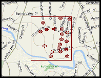 Example #2. Fringe or Suburban Network. In this example, connectivity is compromised by the bounding water feature and patterns of modern suburban development trends (curvilinear streets and cul-de-sacs). This gives a beta index of approximately 1.4 (CI = 26 Links divided by 16 Nodes = 1.37) |
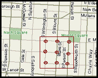 Example #3. Urban or Central Business District Network. For this section of a downtown, the connectivity index for the area in the red box is very high (2.67 connectivity index). Indeed, a connectivity index this high is very close to the theoretical maximum of 3.0 achieved with a four-node, grid-based network. (CI = 24 Links divided by 9 Nodes = 2.67) |
| Lowe and Moryadas, The Geography of Movement. (Washington, DC: Houghton-Mifflin Co.), 1975. pp. 78-109. Criterion Planners and Engineers, INDEX PlanBuilder® Indicator Dictionary. April, 2004. (website: www.crit.com/) |
A second concern relates to edge and boundary effects, or how one cell (or other analysis unit of geography) affects other cells. An example of this is when a pedestrian-friendly older neighborhood is bounded by one or more adjacent, newer neighborhoods that are automobile dependent. The boundaries between the different land use types are neither impervious, linear, nor sharp. The effects of different land uses tend to 'bleed' across the boundaries. Few studies attempted to measure the size and strength of the cross boundary effects.
Studies that accounted for edge and boundary effects often used rectilinear overlay grids to define consistent manageable cells and to evaluate the interaction between adjacent cells. The strength of the interaction was often assumed to be proportional to the shared length at the cell boundary. Using this viewpoint adjacent cells with similar characteristics tend to reinforce one another while adjacent cells with dissimilar characteristics tend to have weaker effects. One difficulty with the 'gridiron' model is how to estimate the effect where four cells come together at their vertices. Because the shared boundary length is zero this model would assume that the interaction between any two cells that touch only at their corners is minimal, or even zero. The traditional way of overcoming edge effects is to use have very small units of geography. The difficulty of collecting data increases as the size of the individual study unit (e.g., traffic analysis zone) shrinks, making this solution difficult to apply for a large study area. An interesting side note to this discussion is that at least one researcher has pointed out that hexagonal input units of geography would provide equal edges all the way around a cell's perimeter thus eliminating many of the difficulties associated with grid systems
Both regional and local scale analyses have faced significant problems in overcoming data shortfalls and inconsistent or subjective measurements of input data. The research did not reveal any attempts to establish forward or backward links between land use strategies and changes in vehicle fleet composition, percent grade, percent cold starts, ambient air temperature, or patterns of acceleration and deceleration. Most of these omissions are understandable since addressing them would have required making assumptions that are both not intuitive and difficult to test about long-term vehicle ownership trends or changes in the physical space of a study area. However, a significant research topic worth exploring deals with the number of cold starts that occur in various local scale studies of built environments. One of the few papers to deal with this specific research variant (Frank, et al, 2000) found that employment densities are inversely related to trip generation (cold and hot soak), travel time, and distance traveled. One hypothesis from such research would be that closer proximity to compatible uses might cause more trip chaining and hence fewer cold starts, leading to lower overall emissions. This situation is generally not accounted for in four-step travel demand models, but may be better addressed in tour-based models (see also Section 5.2.2).
Background. It is often desirable to consider not only the capacity of facilities to carry traffic, but also the number of alternative paths that can be used to get from one location to another. Termed connectivity, this is an important feature of any transportation system for a number of reasons:
Street systems with greater degrees of connectivity offer greater possibilities for rerouting traffic during a temporary closing of one or more links in the system;
Higher connectivity implies a more robust transportation system, one that is able to provide users with greater degrees of freedom in making travel choices during periods of heavy traffic and accommodating trip chaining (making brief stops at different places during a trip);
Greater connectivity typically equates to a greater capacity for moving and distributing traffic, and potentially reducing congestion levels; and
Areas with more connectivity have better access to land, with implications for the diversity and intensity of potential developments in those areas.
Application. There are a number of ways that the degree of connectivity can be measured in a transportation network, including density of streets (links) or intersections (vertices) within a given geographic space. One of the easiest methods to understand and apply is the beta index: simply divide the number of links by the number of intersections plus cul-de-sacs (which are collectively called "nodes").
The higher the ratio of links to nodes, the better connected is the overall network in a study area. The theoretical maximum value is 3.0; however, in any larger network (more than 32 nodes) it can be demonstrated that this maximum value rapidly converges to 2.3. "Good" connectivity can be said to occur in street systems where the connectivity index (CI) is between 1.4 and 1.8. In order to put this ratio into a context that is more easily understood, examples are shown at left.
When calculating the beta index, it is important to count those links (streets) that go from the last node outward. Hence, the selection of the study area boundary is critical when calculating the CI. Averaging the results by shifting the red "frame" around slightly in the examples on this page is a good practice to ensure that a representative CI is chosen for the area.
Other Measures of Connectivity. No one measure of connectivity is necessarily a "perfect" indicator. The size of the study area or distance between nodes is not considered in the calculations for the beta index. However, some measures of connectivity can be weighted by the study area size so as to describe the impact of distance on the traveler.
Other indices include: gamma (difference between actual and maximum number of link connections); alpha (incorporating the cyclomatic number, or the number of "loops" in a network); and the Shimbel, or dispersion, index (which does incorporate distance between nodes). A simple and potentially useful index that measures how well a place is connected to the area around it has been proposed by Criterion Planners and Engineers. A cordon line is first drawn around the study area. Then the average distance between street intersections at the cordon indicates how well the area is connected to the "outside world."
1 This comment came from the Sacramento case and may apply only to EMFAC. MOBILE 6.2 allows a time horizon to 2050 although vehicle turnover stops around 2025 when MOBILE's entire fleet is on the same technology tier.


