1. Summary of Objectives of Study
2. Project Approach and Discussion
4. Recommendation of Best Practices
Equation 1. Calculation of New Distribution for Three-Years-Newer Fleet, First 3 Years
Equation 2. Calculation of New Distribution for Three-Years-Newer Fleet, Last 22 Years
Equation 3. Calculation of VMT Fraction Increased by 30% for Light-duty Vehicles
Equation 4. Calculation of New VMT Fractions for Vehicles Other Than Light-duty Vehicles
Equation 5. Calculation of VMT Fraction Decreased by 30% for Light-duty Vehicles
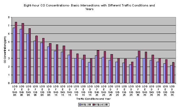
Figure ES-1. Maximum CO Concentrations Near Typical Intersections and Freeways Using MOBILE6
Figure 2.2.1. Cumulative Frequency Distributions of Light-duty Vehicles as Used in MOBILE6
Figure 2.2.4. Distribution of Soak Times for Vehicles Parked in a CBD Garage
Figure 2.2.5. Percentage of Vehicles Parking Duration Distribution
Figure 2.2.7. 2005 MOBILE6.2 CO Emission Factors versus Average Speed
Figure 2.2.8. 2035 MOBILE6.2 CO Emission Factors versus Average Speed
Figure 2.2.9. Maximum CO Concentrations near Typical Intersections and Freeways
Figure 2.2.10. Maximum CO Concentrations near Major Intersections and Freeways
Table 2.2.1.1. New York Route9A: MOBILE4.1 and MOBILE6.2 Idle Emission Factors (g/hr)
Table 2.2.1.2. New York Route9A:MOBILE4.1 and MOBILE6.2 20 mph Emission Factors (g/mi)
Table 2.2.1.3. New York Route9A:MOBILE4.1 and MOBILE6.2 30 mph Emission Factors (g/mi)
Table 2.2.1.4. Traffic Operations for Urban and Suburban Intersections
Table 2.2.1.5. Percent Change in 1-Hour CO Concentration from the Freeway Modeling
Table 2.2.1.8. Intersection Parameters Used for Start Modeling
Table 2.2.1.9. Peak Ambient CO Concentrations from Start Modeling
Emission factor models, specifically EPA's MOBILE series of models, are critical to assessing the emissions and air quality ramifications of transportation strategies, programs and projects. They serve as the underlying analytic tool for the development and evaluation of mobile source emissions in State Implementation Plans (SIPs), conformity determinations, and project-level impact analyses. As such, changes in these emission factor models will directly impact project-level analyses.
The increased flexibility in specifying inputs to MOBILE6 1 has allowed the inclusion of facility functional classes, increased number of vehicle classifications and improvements in emission estimates that are now based more characteristically on trip starts and length. However, most of the improvements in MOBILE6 have been directed at improving regional emission estimates, not project-specific estimates. Thus, the changes in MOBILE6 may inadvertently undermine the validity of the project-level assessment procedures. The implication of how the application of MOBILE6 will affect project-level analyses has not been explored. It is anticipated that the project-level analyst will require additional guidance and resources in selecting MOBILE6 modeling options.
Across the country, most Metropolitan Planning Organizations' (MPOs) and state Departments' of Transportation (DOTs) staff have begun to use MOBILE6 in project-level dispersion modeling. As a result, a goal for this project was to inform practitioners in the transportation community about the most critical and sensitive input parameters to MOBILE6 affecting project-level transportation and air quality analyses so that resulting transportation decisions are improved.The results of this project provide transportation planners with information that can help them develop cost effective strategies for using MOBILE6 in project-level dispersion analyses and to help design mitigation strategies when hotspot modeling is needed.
The CAL3QHC roadway intersection model is typically employed to determine potential air quality impacts for project-level analysis. CAL3QHC uses both an idle emission factor and an appropriate emission factor based on each link's free flow speed. The recent changes incorporated in MOBILE6 may produce changes in the idle and free-flow speed emission rates. Because these two emission rates are the input parameters for CAL3QHC, the modeling output may be different using MOBILE6 versus earlier versions of MOBILE.
Overall the study explores how the use of MOBILE6 impacts project-level analyses. The study is divided into three main components addressing the following three questions:
A review of the MOBILE6 changes that may impact project-level analysis suggest that ten emission change scenarios will be of primary interest to the project-level analyst in assessing the difference between using MOBILE5 and MOBILE6. These scenarios reflect both typical applications and/or potential changes from national distributions and anticipate significant impacts to carbon monoxide (CO) emission factors. Findings show that, in 2005, MOBILE6 produces lower emission factors than MOBILE5 at low speeds (between idle and 19.5 mph) across all temperatures and for all scenarios. This trend is reversed for higher speeds. For 2035, MOBILE6 emission factors are lower than the corresponding MOBILE5 emission factors for all scenarios, including higher speeds. Thus, for the earlier years, MOBILE6 will always estimate lower emission rates than MOBILE5 for low speeds, but higher emission rates for higher speeds. For later years, MOBILE6 will always provide lower emission rates than MOBILE5.
To assess the validity of the CAL3HC model, comparisons are made between the emission factor models MOBILE4.1 and MOBILE5, which was used in the model evaluation and selection study. The idle emissions decrease significantly when using MOBILE6.2, relative to either MOBILE5 or MOBILE4.1, while moving emissions increase. Historically, analyses of roadway intersections have found that high concentrations are a result of large queue emissions and hence, the idle emission factor. This tradeoff in emissions will likely impact the CAL3QHC model by lowering concentrations in most situations where queue length is important. Since the model performance evaluation of CAL3QHC in the Route 9a model validation study tended to underpredict emissions for all intersections evaluated, one would expect model bias to increase. However, this prediction somewhat contrasts with the other more recent major study, NCHRP25-6, which suggested that MOBILE6.2 will improve model performance relative to its evaluation based on using MOBILE5. Some of this difference may be the result of changes in engine technology since these evaluation studies were based on pre-1990 and pre-1995 vehicles. It is possible that differences between the two MOBILE models may be considerably different for a newer fleet of vehicles. If, however, today's fleet is analogous to the NCHRP's pre-1995 fleet, then the use of the MOBILE6.2 model in project-level analysis will likely improve model performance.
With the release of MOBILE6, EPA recommended that, because nearly all emissions are hot-stabilized, the model's emission factor estimates should be used without adjustment for start fraction, except for special modeling situations (such as parking lots) which may require the modeling of the effects of engine starts. ICF has identified additional locations under which start emissions should be considered. For each of these locations, a methodology has been identified for estimating start emission characterizations. In general, these methods use a combination of historical survey data in combination with an estimate of facility size to estimate the number of starts. In addition to borrowing results from these studies, several alternative methods are discussed for collecting data to characterize soak distribution for project-specific locations. These methods are relatively inexpensive to implement relative to a fully instrumented vehicle study.
Implementation of MOBILE6 will affect the results of project-level analysis. An assessment is made using the CAL3QHC model for a typical high volume freeway and high volume intersection. Modeling is performed for a variety of emission scenarios representing the expected range of differences between MOBILE5 and MOBILE6 models for the base year of 2005 and a future year of 2035. In addition, the impact of start emissions are assessed for an urban and a suburban intersection for several levels of service, assuming that a fourth of the vehicles arriving are in start mode.
For the high volume freeway scenario, MOBILE6 produces higher concentrations than MOBILE5 for 2005, while in 2035, MOBILE6 is more comparable to MOBILE5, but produces higher concentrations at lower temperatures. Thus, application of MOBILE6 for freeways in the near future years coupled with high traffic volumes and high background concentrations may present problems not currently demonstrated with MOBILE5. For the suburban intersection scenarios, MOBILE6 produces lower ambient CO concentration values for every combination than does MOBILE5. For the central business district (CBD) intersection, too, the concentrations produced by the MOBILE6 model are always lower than those from MOBILE5. For the start scenarios, both the urban and suburban intersections show problems achieving the eight-hour CO standard. For 2035, the urban intersection meets the eight-hour standard, but the suburban intersection does not. In all cases, these exceedances are associated with the high idle emissions factors associated with start emissions. Thus, intersections with high start fractions and high volumes appear to have the potential for exceeding the CO standard.
Use of MOBILE6 has the potential to affect the process through which project-level analysis is performed. Potential changes include the need for additional information; local or state procedures, including estimating background concentration; and impacts on mitigation strategies. For those agencies using mostly default values, no additional effort has been found in applying the MOBILE6 model, while those developing location-specific input indicated that additional effort is needed to develop inputs to the model. Almost all state agencies contacted indicated that more time is required to complete project-level analyses using MOBILE6 compared to using MOBILE5, ranging from several hours to 40 hours. Most states have also found that future background concentrations of CO should be lowered as a result of MOBILE6's strong downward CO emission trends and estimates of regional vehicle miles traveled (VMT) growth. As a result, a number of locations have, or are looking at, adopting new procedures for determining future background CO levels. For intersection modeling using MOBILE6, areas will need to change their "worst case" modeling receptors from being intersection-based to using a mid-block location. For mitigation, the traditional approach of increasing intersection capacity to achieve higher average speeds may result in overall emission increases.
Use of MOBILE6 has the likely potential to affect the screening assessment procedures for project-level analysis. This study identifies current efforts in revising screening-level procedures, as well as develops an approach for setting a threshold screening-level procedure. In addition, the study identifies limitations in the applicability of the screening approach.
The assessment finds limited potential for the CO National Ambient Air Quality Standards (NAAQS) violations for project-level studies under most typical conditions. In the past, level of service (LOS) C has been widely used as a screening threshold to reduce the need for detailed modeling. Due to the changes from MOBILE 5 to MOBILE6, the relative role of cruise emissions has increased, while the idle emission factors have been substantially reduced. As shown in ES-1, detailed modeling can likely be excluded for both intersection and freeway locations with LOS E or better under a wide variety of conditions, especially when looking beyond the near-term period (2015 or later). It was also observed that, for a freeway operating at LOS E, modeling results suggest the potential for higher CO levels than at an intersection operating at LOS F. Thus, freeway scenarios should be examined, along with intersections, in setting a screening threshold assessment procedure. Results also show that, for intersections, the corner receptors no longer exhibit the highest concentration.
The applicability of this screening approach is dependent on the circumstances of a given project and how closely they resemble typical conditions. Several exceptions to these typical conditions have been identified. These include: locations in very close proximity to very high volume freeways; locations with an extraordinary rate of start emissions, such as near a park and ride lot or CBD parking garage; a fleet much older than the national default age distribution; and locations with an unusually high background concentration. These type cases will need to be examined on a case-by-case basis. Nevertheless, it appears likely that the vast majority of typical projects will not require detailed modeling if the traffic analysis indicates that all signalized intersections and freeway sections will operate at LOS E or better.
Figure ES-1. Maximum CO Concentrations Near Typical Intersections and Freeways
Using MOBILE6