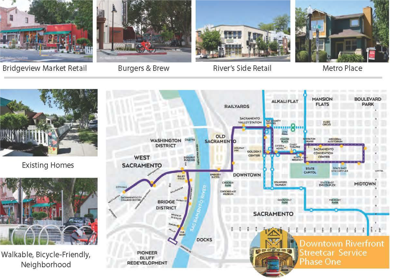
Washington District Development Opportunities including Transit-Oriented and Riverfront Mixed Use District. The revitalization of the city's most historic, walkable, riverfront mixed-use district is well underway with new homes, parks, trails, streetscaping, and public arts.
Source: Credit to the Washington District, CA
| Location | West Sacramento, CA |
|---|---|
| Project Sponsor / Borrower | City of West Sacramento |
| Program Areas |
|
| Value Capture Techniques | Development Impact Fees / Mobility Fees Right-of-Way Use Agreements Special Assessment: Community Improvement Districts & Local Improvement Districts Enhanced Infrastructure Financing District (EIFD) |
| Mode | Multi-Modals: Local Road, Pedestrian / Bicycle / Transit |
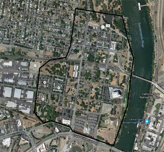
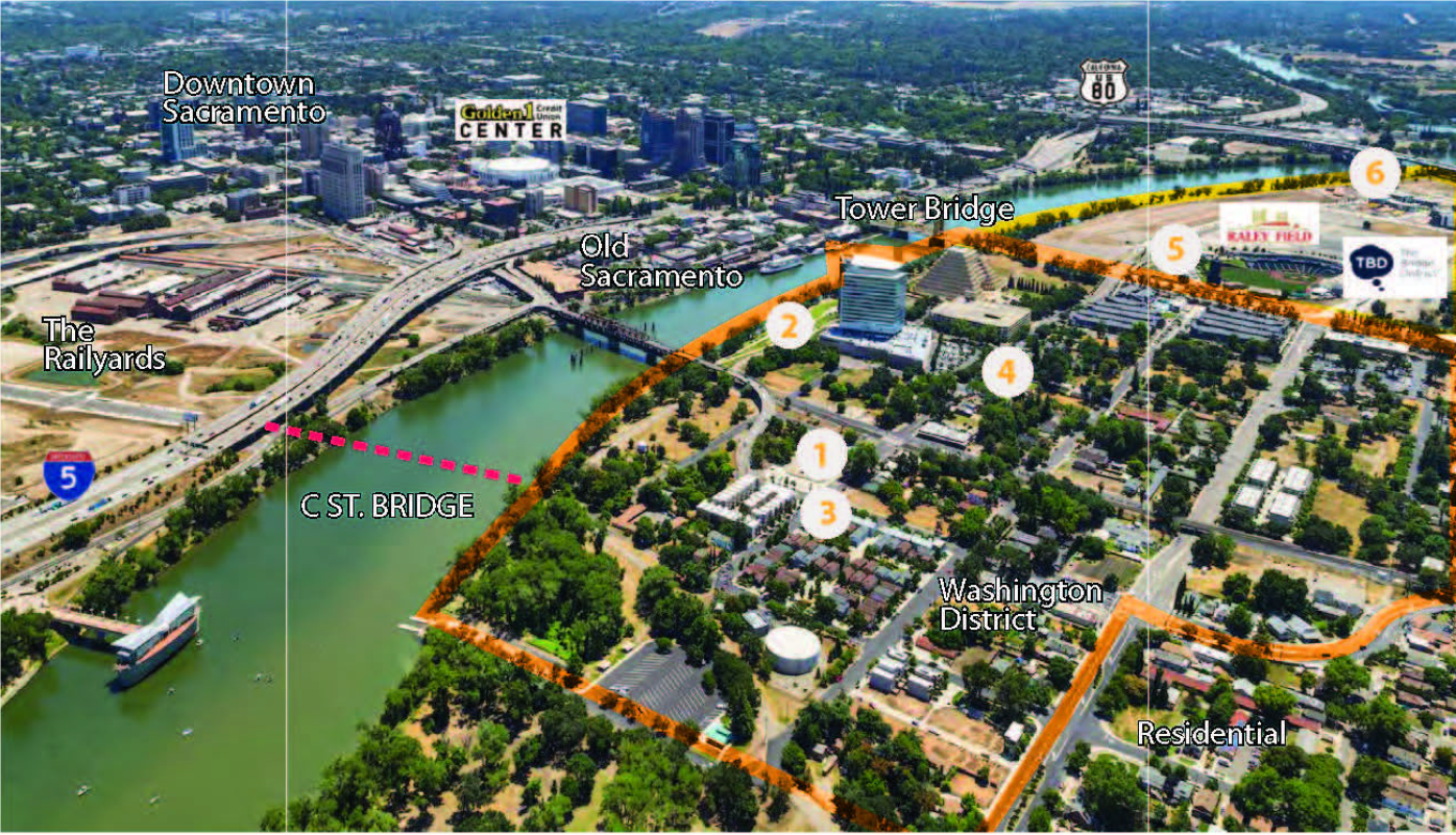
| Description | The Washington District is an urban 194-acre historic neighborhood located on the West Sacramento riverfront within a mile of downtown Sacramento. Bound by the Tower Bridge Gateway on the south, the Sacramento River on the east, a street on the north, and portions of 6th Street and 8th Street on the west, the Washington District is an area that has potential for sustainable, mixed-use development. It features a mix of land uses and building forms with the City's oldest buildings, a walkable commercial district, some of its most established residential neighborhoods, and tree-lined streets. The City finished the existing Washington Specific Plan (WSP) in 1996 and much has changed since then. Two landmark office buildings established firm anchors along the waterfront and a new residential, commercial, and entertainment node was constructed. The River Walk Regional Park was constructed from the Tower Bridge Gateway to Ed Street. The grade-separated State Route 275, originally disconnecting the Washington Area from the Bridge District, is now an at-grade city arterial, Tower Bridge Gateway. The area is designated for pedestrian-oriented, transit-oriented development (TOD) due to its large commercial developments and proximity to downtown Sacramento employment centers. In 2011, the neighborhood earned a U.S. Housing and Urban Development (HUD) "Sustainable Community" designation to fund planning efforts. On February 18, 2015, the City Council adopted the Washington Realized document, a strategy intended to shift development patterns towards compact, transit served, and mixed-use development. In 2014 the City received a National Endowment for the Arts grant in partnership with the City of Sacramento. In 2018 the City received a $1.5 M grant to replace a boat dock. In 2015 the City received a CA Climate Investment Fund grant of $3.3 M and combined it with local funds to construct $13 M of underground infrastructure rehabilitation and up sizing and new sidewalks, lights and landscaping and a public art installation to enhance walkability. In 2015 an extension of the River Walk was designed with CDBG funds and in 2017 the City was awarded $2.6 M of SACOG funds for River Walk North and other frontage facilities including bike and ped rail crossing improvements. This will start construction in spring 2021. Sacramento and West Sacramento are currently in PAED phase for a new replacement bridge and conversion of the existing historic bridge. Revitalization plans feature 3,300 residences, 2.4 million square feet of commercial office, and 350,000 square feet of retail. The District is currently undergoing more change and the Washington Realized Sustainable Community Strategy has resulted in securing several grants to implement the solutions to infrastructure and park deficiencies, defining transportation system improvements, and isolating impediments to progress. It plans on providing increased transportation choices, providing a range of housing and commercial opportunities, enhancing air quality, and more. Also included in this plan is a pedestrian priority layer, which focuses on streets anticipated to serve as major circulation, retail, recreational, and transit access. For all streets in the network's corridors, they will feature connected sidewalk and street crossings so pedestrians may safely walk throughout the District. A large hotel and condominium project is currently in design for a 5-acre parcel on 3rd Street and Tower Bridge Gateway. |
| Cost | $18M; The cost estimate is a work in progress based on current data and Council direction. The amount(s) will change and evolve as further designs are completed and property is acquired for park uses. |
| Funding Sources |
|
| Project Delivery / Contract Method | Design-permit-bid-build |
| Private Partner | Black Pine 440 West LLC, Riverside LLC, Metro Place, D&S Development, KIND LLC, Raleys Corporation |
| Project Advisors / Consultants |
|
| Lenders | N/A |
| Duration / Status | The horizon year for this build-out plan is 2035 and the project was initiated in winter 2018. In 2019, community engagement commenced in the spring with the vision and conceptual plan continuing through the summer. The Specific Plan preparation ran until the end of 2019 and review and adoption of the Plan is currently underway. |
| Financial Status / Financial Performance | Completed in January 2019 |
| Innovations |
Bicycle
Riverfront Experience
|
| Related Links / Articles | |
| Contacts | Katy Jacobson |