


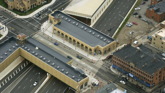
An aerial view of the cap above I-670. Photo credit: Chicago Tribune
| Location | Columbus, Ohio |
|---|---|
| Project Sponsor / Borrower | City of Columbus / Continental Real Estate Companies |
| Program Areas |
|
| Value Capture Techniques | Right-of-Way Use Agreement |
| Mode | Highway and Local Road |
| Description | The Cap at Union Station is a $7.8 million, 25,500-square-foot retail development reconnecting downtown Columbus, Ohio with the Short North arts and entertainment district. The Cap is located along High Street, a major thoroughfare running north from downtown Columbus and the Columbus Convention Center. The project is carried above I-670 - Columbus' Inner Belt Highway - on three parallel bridges. A central bridge carries through traffic across the highway, while the two flanking structures support the retail buildings. The retail buildings are light-weight structures clad in fiberglass-reinforced plastic designed to be reminiscent of Columbus Union Depot, the former train station designed by Daniel Burnham in the late 1890s that was replaced by the Convention Center in 1976. The construction of I-670 in the 1950s cut a 200-foot swath across downtown Columbus, separating the city center from surrounding neighborhoods, including Short North. In the 1990s the neighborhood was revitalized with new shops, restaurants and galleries opening and a wave of residential redevelopment. The notion of bridging the gap between downtown and Short North was included in the city's North Market Plan in 1989. The idea gained traction in 1996 when the Ohio Department of Transportation (ODOT) advanced plans to widen I-670. Members of the Short North Business Association advocated a pedestrian-friendly solution to encourage foot traffic from the busy convention center. A variety of solutions were considered, including constructing a hardscape park above the highway and a 1,000-foot-wide cap. However, the notion of a bridge surrounded on each side by retail shops gained the greatest traction and caught the attention of Continental Real Estate, a local developer. In 1999, Continental signed a memorandum of understanding with the City of Columbus stipulating that if they city could gain clear title to the development rights above the highway and obtain permission from ODOT and FHWA to build the Cap platforms, the company would enter into a lease agreement for the platforms and construct the retail buildings. When I-670 was originally constructed, the State had only acquired ground rights to the property, so the City of Columbus Attorney's Office needed to conduct title searches for the 13 parcels below the Cap and obtain permission from the owners. This was a costly process that took two years to complete. Gaining the necessary permission from FHWA was also challenging because federal statutes mandated that the City charge market value for the development rights since they would not be used for transportation purposes. However, construction costs on the platforms would be well above market rates, so the City was able to lease the platforms to the developer for $1 per year, in exchange for 10 percent of the ongoing profit of the project. In addition, the project could not infringe upon ODOT's ability to operate I-670, notably closing and evacuating the Cap in an emergency. In addition, no windows were allowed on the rear facades, access to the roof or rear of the buildings was not allowed, and no lighted signs or advertisements could be visible from the highway. Providing utility connections to the development was also challenging given that the buildings are located on bridge structures above an interstate highway. The utility lines are located in internal bays within the bridge, which are accessible from the interior of the buildings. The bays are insulated and heated during winter to prevent freezing. |
| Cost | Preliminary Architectural Designs - $115,000 Cap Platforms and Utility Connections - $1,625,000 Development Costs - $7,800,000 |
| Funding Sources | Public Funds
Private Funds (Continental Real Estate Companies)
|
| Project Delivery / Contract Method | Right-of-Way Use Agreement |
| Private Partner | Continental Real Estate Companies |
| Project Advisors / Consultants | Meleca Architecture and Urban Planning - Architect Jezerinac Geers & Associates - Structural Engineer Benjamin D. Rickey & Company - Historic Preservation Columbus City Attorney - Legal |
| Lenders | Commercial Banks |
| Duration / Status | City of Columbus North Market Plan published 1989 Planning and project approvals 1996-2004 Construction began April 2002 Leasing began 2003 Project completed October 2004 |
| Financial Status | Closed |
| Innovations |
|
| Related Links / Articles | |
| Contacts | Not available |
i Detailed information in this project profile is taken from the Urban Land Institute Case Study on the Cap at Union Station.