


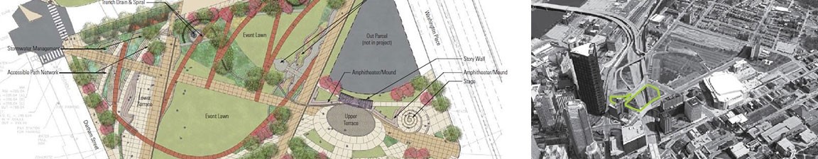
The Cap will be a 3-acre urban open space connector covering the below grade I-579 highway providing for a seamless connection between the Hill District to the east, and Downtown to the west.
Source: Credit to The Public Auditorium Authority of Pittsburgh and Allegheny County
| Project Name | I-579 "Cap" Urban Connector Project: Bridging a Critical Gap to Revitalize the Hill District |
|---|---|
| Location | Pittsburgh, Pennsylvania |
| Project Sponsor / Borrower | City of Pittsburgh |
| Program Areas |
|
| Value Capture Techniques | Private Contribution |
| Mode | Pedestrian / Bicycle / Light Rail Transit |
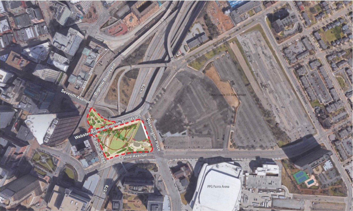
| Description | The I-579 “Cap” Urban Connector Project will reconnect a disadvantaged community (Hill District) to centers of employment, education and services (Downtown Pittsburgh) via the construction of a Cap structure that spans the below grade I-579 interstate highway. The 3-acre Cap is a “ladders of opportunity” project for the economically disadvantaged Hill District community. The Cap provides a new open space and replaces what has been a barrier between the two communities with a new connector in the urban core of Pittsburgh and includes safe and accessible bicycle and pedestrian pathways and facilities over and around its perimeter, providing a better connection for people dependent on walking or biking between the Hill District and Downtown. Improved facilities for the disabled are also a part of this project. The I-579 Cap Urban Connector Project will add a new “cap” structure over a portion below grade of I-579 Crosstown Boulevard in Pittsburgh, Pennsylvania. It will improve the adjacent intersection and underutilized vacant land parcels. It will be bound by Washington Place, Centre Avenue, Chatham Street, Bigelow Boulevard, and land to the north of Bigelow Boulevard. The project site includes air space above the I-579 highway and adjoining land parcels. It is located near the proposed bus rapid transit (BRT) system, which will connect the City with its Oakland suburb. The cap will be approximately 52,800 square feet of pre-stressed concrete adjacent box beams. The bridge deck will be an eight-inch thick reinforced concrete slab composite with the beams. The live loading on the structure will be a full pedestrian load. The cap will span across I-579 west to east with a combination of a two-span structure (adjacent to the Centre Avenue Bridge on the southern limit) and a three-span structure (adjacent to the Bigelow Boulevard Bridge at the northern limit). The surface of the cap will provide three acres of open space with pedestrian pathways and bicycle paths. It will improve nearby connecting intersections, plus provide recreation and performance areas, rain gardens, and other public amenities designed by local artists. By upgrading sidewalks, crosswalks, lighting, landscaping, and rest areas, along with incorporating new pedestrian and bicycle signage, the project is expected to enhance safety for the public. The Cap will create safe and accessible routes for walking and biking between the Hill District and the City, including connections to the free fare Downtown/North Shore subway. The cap will offer improved links to public transportation, including a new bus stop on Centre Avenue at the cap site, and a bike-sharing station. It will also improve safety at the Chatham Street and Bigelow Boulevard intersection. Americans with Disabilities Act (ADA) compliant curb-cut ramps and crosswalks will be constructed with associated signs, audible/count-down pedestrian signals, and pavement markings. New ADA compliant walkways leading to the intersection also will be constructed. Contributing to the City’s Clean Diesel Emission requirements, the project will add trench drains to help catch storm water and redirect it into rain gardens or back into the public drain system. |
| Cost | $32 million ($20 million from FY2016 TIGER Discretionary Grant (TIGER VIII) funding, and $12 million from state, local and private funding, as well as a land match). |
| Funding Sources |
|
| Project Delivery / Contract Method | Design-Bid-Build, The Joseph B. Fay Company is the prime contractor |
| Private Partner |
|
| Project Advisors / Consultants |
|
| Lenders | N/A |
| Duration / Status | Construction for the project began in 2019 with scheduled completion in 2021. |
| Financial Status / Financial Performance | Construction completion is anticipated for November 2021 |
| Innovations |
|
| Related Links / Articles | |
| Contacts | Facilities Director |
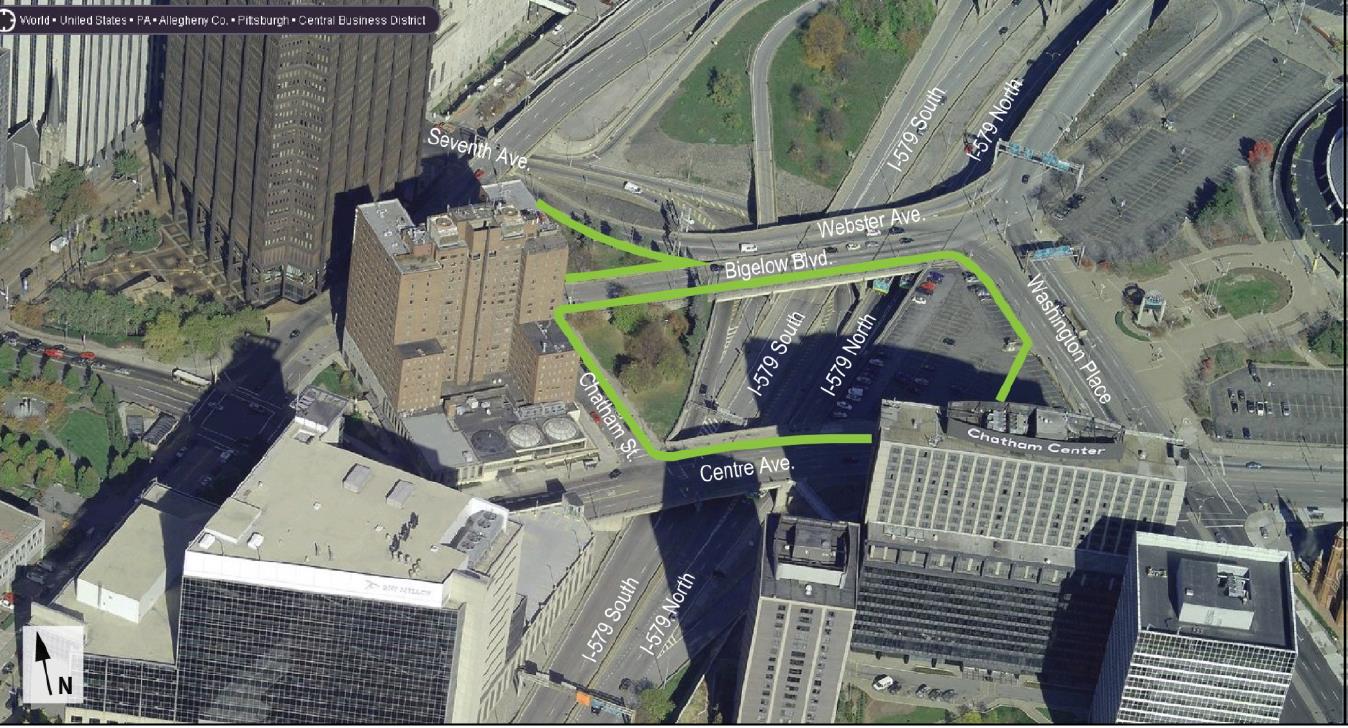
The I-579 Cap Urban Connector Project (also known as the Cap Project) will consist of the construction of a new “cap” park structure spanning over a portion of I-579. The Cap Project is bounded by Washington Place, Centre Avenue, Chatham Street, Bigelow Boulevard and land to the north of Bigelow Boulevard
Source: Credit to Pittsburgh Downtown Partnership
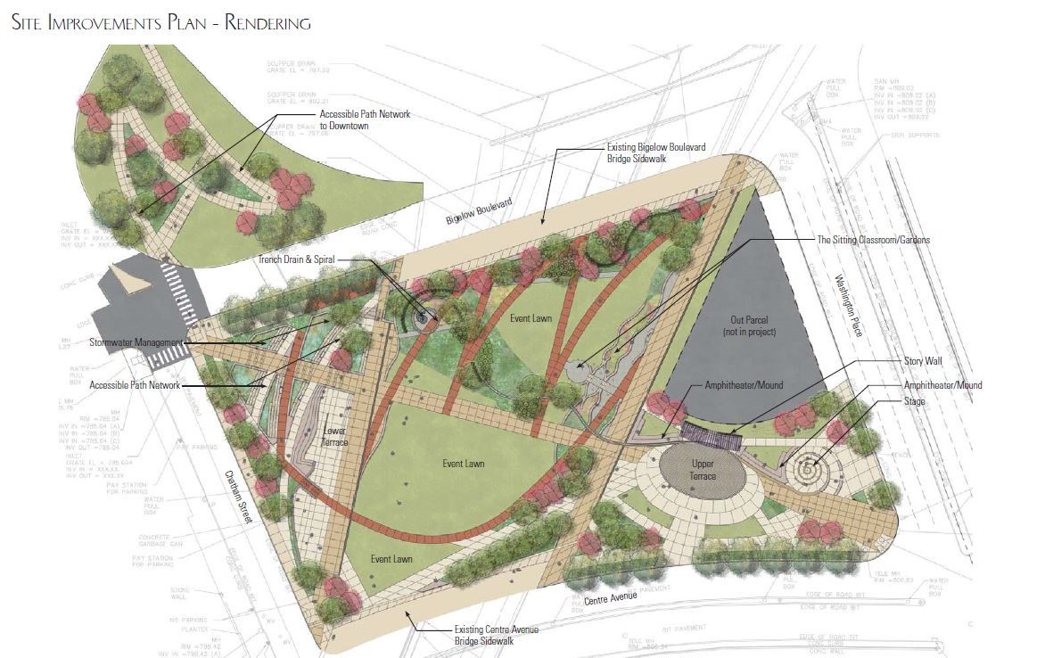
The final design, a design review and community process was undertaken to obtain input from residents of the Hill District and other stakeholders regarding the details of design of the 3-acre public urban open space that will make up the surface of the “cap.”
Source: Credit to the Interstate-Guide