


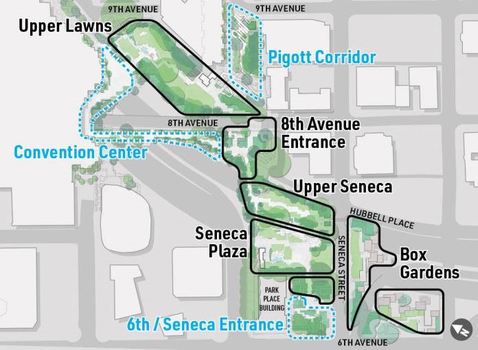
Project background and concepts. Park areas traced in black including the Upper Lawns, 8th Avenue Entrance, Upper Seneca, Seneca Plaza, Park Place Building, and Box Garden will be prioritized for improvements. Note that the areas bordered by blue includes Pigott Corridor, 6th/Seneca entrance and Convention Center are owned by other parties and will see limited improvements.
Source: Credit to the City of Seattle
| Project Name | Freeway Park Improvements: Seattle, Washington |
|---|---|
| Location | Seattle, Washington |
| Project Sponsor / Borrower | Seattle Parks & Recreation (SPR) |
| Program Areas |
|
| Value Capture Techniques | Private Contribution; Right-of-Way Use Agreements (Cap the Freeway) |
| Mode | Other: Freeway Park |
| Description | The Freeway Park Improvements Project will repair, restore, and potentially enhance original park features in support of the park’s daily use, maintenance, and programming. The goal of the project is to make the park more welcoming, bring people back to the park, and restore its role as a centerpiece of Seattle’s park system and an icon of landscape architecture. It was the first park built over an interstate highway over four decades ago. The Seattle’s Freeway Park, Washington was the nation’s first park built atop a highway to reconnect the neighborhoods the highway had torn asunder. In 1966, I-5 was cut through the edge of Seattle; running north-south, it divided downtown from neighborhoods to the east. When Freeway Park opened in 1976, it became a model for other cities seeking to heal the divisions that postwar highway construction had caused. It opened between 6th and 7th Avenues over Interstate 5 in July 1976 as a celebration of the U.S. bicentennial. The 5.2-acre park, the largest public park in downtown Seattle, was built with Forward Thrust bond funds for residents, shoppers, and visitors to enjoy. The park includes distinct areas tied together by concrete, greenery, and furnishings, along with a series of irregular, linked plazas that are intertwined and enclosed by board-formed concrete planting containers and walls. It includes a 30-foot concrete canyon and Naramore Fountain, which existed before the park was built, but was incorporated into the park’s design. Some say the brutalist architecture used in Freeway Park’s design gave an unwelcoming feel. The park’s structure also did not support some of the trees planted within its grounds. Over time, the surviving vegetation became overgrown and the park fell into disrepair. The expansion project aims to replace 12 entrances to the main part of the park with four primary entrances located along key city walking routes that pass the park and connect to primary walking routes through the park. Plans are currently underway to repair, restore, and enhance Freeway Park’s original features in support of daily use, maintenance, and public programming. Proposed improvements include infrastructure upgrades related to lighting, wayfinding signage, planting, accessibility, entrances, programming, and services; repairs to drainage, irrigation, and seating; new restrooms, play-safe fountains, and permanent storage; and a café, information booth, children’s play area, gateways, and infrastructure for events and daily programming. |
| Cost | $10 million (including $6 million of construction budget)
|
| Funding Sources |
|
| Project Delivery / Contract Method | Design-Bid-Build |
| Private Partner |
|
| Project Advisors / Consultants |
|
| Lenders | N/A |
| Duration / Status | Construction began in 2019 and is scheduled to be complete in 2022. The original goal was to complete the improvements to Freeway Park by the end of 2021. The current timeline calls for construction to start in 2022. |
| Financial Status / Financial Performance | The project totaled $10 million, with $6 million being designated to construction. More than $9 million was intended for capital improvements and the remainder funded the activation. |
| Innovations |
|
| Related Links / Articles |
|
| Contacts | Sandra Albertsen |
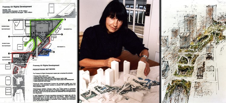
Left: Image from the Freeway Air Rights Master Plan. Center: Designer Angela Danadjieva and a model of Freeway Park expansions. Right: Sketch of Freeway Park expansions.
Source: Credit to the University of Washington, College of Built Environments Visual Resources Collection
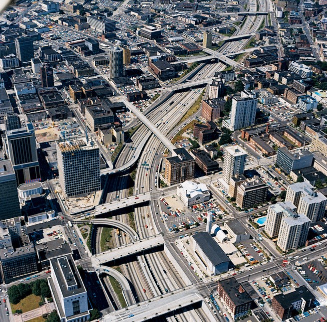
Looking north along Interstate 5 before Freeway Park was built. The Naramore Fountain and the under-construction Park Place tower are visible at center left.
Source: Credit to the Seattle Parks Foundation
Freeway Park shortly after it opened on July 4, 1976.
Source: Credit to the University of Washington, College of Built Environments Visual Resources Collection
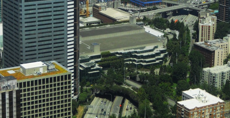
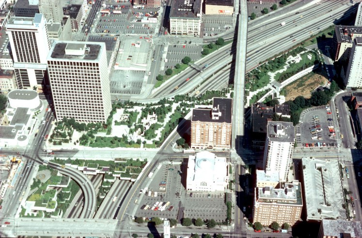
The original facility of the Washington State Convention Center and its associated extensions of Freeway Park, looking north.
Source: Credit to Scott Bonjukian, the Seattle Parks Foundation