Post-Earthquake Reconnaissance Report on Transportation Infrastructure: Impact of the February 27, 2010, Offshore Maule Earthquake in Chile
CHAPTER 1. INTRODUCTION
1.1 BACKGROUND
Over the course of the last century, Chile has experienced several strong earthquakes. According to the United States Geological Survey (USGS), M8.2 earthquakes struck the nation in 1906, 1943, and 1960, and an M8.0 earthquake hit in 1985. The M8.2 earthquake in 1960 was a foreshock that occurred the day before the largest earthquake ever recorded, the M9.5 Chilean earthquake. The offshore Maule earthquake on February 27, 2010, was measured at M8.8 and lasted more than 2 min. It is estimated that this earthquake was approximately 500 times more powerful than the earthquake that devastated Haiti in January 2010. Several aftershocks, including nine events with a magnitude exceeding 6.0, occurred in the days following the Chilean earthquake.(1) The M8.8 event is the fifth largest earthquake recorded in modern times and was characterized by its long duration and strong ground motion, which also caused tsunamis across the region. Many bridges and tunnels constructed with seismic design codes similar to the 1983 U.S. and European codes were damaged in the earthquake.
Because of the size of the event, the intensity of the ground shaking, the geological similarity of the Maule region and the Northwestern United States (e.g., Washington and Oregon's subduction zones), and the comparable nature of the infrastructure construction and seismic design codes used, the performance of transportation infrastructure during this earthquake provided valuable lessons in earthquake engineering. In March 2010, the Federal Highway Administration (FHWA) contacted Chile's Ministry of Public Works (MOP) and worked with University Transportation Center, Washington State Department of Transportation, University of Nevada, and Missouri University of Science and Technology to organize the transportation infrastructure reconnaissance team (TIRT). TIRT and a member of the Earthquake Engineering Research Institute (EERI) were dispatched to Chile on April 3 to perform a comprehensive earthquake reconnaissance. TIRT was supported by local bridge engineers from MOP and local researchers from Pontifical Catholic University of Chile and the University of Chile.
TIRT visited more than 32 transportation infrastructure sites, including highway bridges and port facilities from Santiago down to Tubul, a small city near Concepción. The specific locations visited are shown in figure 1 and listed in table 1 with site names, Global Positioning System (GPS) coordinates, and city and county names.

© Google, Inav/Geosistemas SRL, Europa Technologies, and DMapas
Figure 1. Map. Site locations visited by TIRT.
Table 1. Specific sites' structural names and GPS locations.
Site No. |
Site Name |
Location |
Latitude (S) (degrees) |
Longitude (W) (degrees) |
1a |
Américo Vespucio/Miraflores eastbound |
Santiago |
-33.39 |
-70.77 |
1b |
Américo Vespucio/Miraflores westbound |
2a |
Américo Vespucio/Lo Echevers eastbound |
Santiago |
-33.38 |
-70.75 |
2b |
Américo Vespucio/Lo Echevers westbound |
3 |
I-5/14 de la Fama |
Santiago |
-33.40 |
-70.68 |
4 |
Pedestrian bridge over Route 5 |
Santiago |
-33.34 |
-70.71 |
5 |
Quilicura railway crossing at Avenida Manuel Antonio Matta |
Santiago |
-33.37 |
-70.70 |
6a |
Américo Vespucio/Independencia westbound |
Santiago |
-33.37 |
-70.69 |
6b |
Américo Vespucio/Independencia eastbound |
6c |
Américo Vespucio/Independencia westbound exit ramp |
6d |
Américo Vespucio/Independencia westbound entrance ramp |
7 |
Avenida Romero Acceso Sur overpass |
Paine |
-33.86 |
-70.72 |
8 |
Avenida Chada Acceso Sur overpass |
Paine |
-33.87 |
-70.73 |
9a |
Maipú River (local access bridge) |
Buin |
-33.69 |
-70.72 |
9b |
Maipú River (current Route 5 bridge) |
9c |
Maipú railroad crossing |
10a |
Route 5 railway crossing at Hospital westbound |
Buin |
-33.86 |
-70.75 |
10b |
Route 5 railway crossing at Hospital eastbound |
11 |
Estribo Francisco Mostazal (Avenida Independencia) |
Mostazal |
-34.03 |
-70.72 |
12 |
Las Mercedes Route 5 overpass |
Rancagua |
-34.07 |
-70.76 |
13a |
Claro River |
San Rafael |
-35.18 |
-71.39 |
13b |
Claro River |
14 |
Pichibudis |
Iloca |
-34.88 |
-72.16 |
15 |
Mataquito |
Iloca |
-35.05 |
-72.16 |
16 |
Cardenal Raúl Silva Henríquez |
Constitución |
-35.34 |
-72.39 |
17 |
Llacolen |
Concepción |
-36.83 |
-73.07 |
18 |
Chepe railroad bridge over Biobío River |
Concepción |
-36.82 |
-73.07 |
19a |
Puerto de Coronel Muelle Norte |
Coronel |
-37.03 |
-73.15 |
19b |
Puerto de Coronel Muelle Sur |
20 |
Raqui 1 |
Raqui |
-37.25 |
-73.44 |
21 |
Raqui 2 |
Raqui |
-37.25 |
-73.44 |
22 |
Tubul |
Raqui |
-37.23 |
-73.46 |
23 |
El Bar |
Arauco |
-37.26 |
-73.24 |
24a |
Ramadillas (west, old) |
Arauco |
-37.31 |
-73.26 |
24b |
Ramadillas (east, new) |
25 |
Juan Pablo II |
Concepción |
-36.82 |
-73.09 |
26 |
Biobío River (old) |
Concepción |
-36.84 |
-73.06 |
27 |
La Mochita |
Concepción |
-36.85 |
-73.06 |
28 |
Vía Elevada 21 de Mayo/Cruce Ferroviario |
Concepción |
-36.82 |
-73.07 |
29 |
Rotonda General Bonilla |
Concepción |
-36.81 |
-73.03 |
30 |
Itata River |
Coelemu |
-36.47 |
-72.69 |
31 |
San Nicolás |
San Nicolás |
-36.50 |
-72.21 |
32 |
Muros Talca (SW) |
Talca |
-35.48 |
-71.67 |
1.2 THE TRANSPORTATION INFRASTRUCTURE RECONNAISSANCE TEAM
1.2.1 Objective
TIRT's mission was to conduct a thorough postearthquake investigation concentrating on highway bridges, tunnels, and retaining walls in the areas affected by the earthquake, including the cities of Concepción and Santiago. Performance of these structures, including damaged and undamaged conditions, were carefully documented and analyzed. The information gathered from this effort will be studied, and the results will be used to assess, refine, and improve current design codes and standards that benefit the United States, Chile, and the general engineering community.
1.2.2 Team Members
TIRT included six members led by the FHWA Office of Infrastructure Research and Development, including three FHWA representatives, one representative of the American Association of State and Highway Transportation Officials (AASHTO), and two university representatives. Juan G. Arias, a student representing EERI, joined and assisted the team in the investigation. The team was coordinated by FHWA's Sheila Duwadi throughout the preparation, reconnaissance, and postreconnaissance reporting. The U.S. team members were fully supported by their Chilean colleagues. Figure 2 shows the team members and local participants. Pictured from left to right are Daniel Alzamora (FHWA Resource Center), Dr. Ian Buckle (University of Nevada), Dr. Phillip W. Yen (FHWA team leader), Genda Chen (Missouri University of Science and Technology), Juan G. Arias (University of Nevada), Rodrigo Oviedo (Pontifical Catholic University of Chile), Dr. Jeffrey Ger (FHWA Florida Division), Tony Allen (Washington State Department of Transportation), Sandra Achurra (MOP), and Mauricio Guzman (MOP).
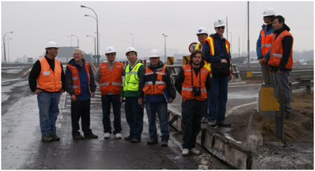
Figure 2. Photo. TIRT team members and Chilean support personnel.
1.3 REPORT ORGANIZATION
This report presents the preliminary reconnaissance findings of the earthquake performance of transportation infrastructure based on available information, visual observations, and preliminary analysis. Chapter 2 describes the seismic details of the earthquake. Chapter 3 presents a summary of Chilean seismic design codes studied by TIRT, and chapter 4 provides the findings of the investigation of structural performance. Chapter 5 documents the geotechnical observations of infrastructure performance, including bridges, retaining walls, and other structures. Chapter 6 presents the lessons learned from this reconnaissance, and chapter 7 offers conclusions and recommendations.
|


