« Previous
8. Examples
Examples: California Irrigation Districts
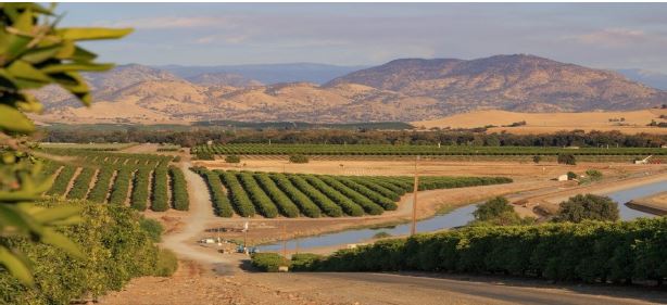
Source: Fresno Water District
Transporting Water to Fertile But Arid Valleys
- The Wright Act of 1897 enabled the creation and operation of irrigation districts;
- Initially, these irrigation districts were funded by user fees levied on the amount of water withdrawn from the canals.
- Large estates next to the canals became valuable, but some owners contributed nothing because they were not farming and not withdrawing water.
- The Wright Act was amended to require special assessments based on land value from all land benefiting from proximity to the canals. Benefiting lands included both farmland and nearby towns.
- Revenues increased and were more equitably distributed among beneficiaries.
- Special assessments motivated the intensive cultivation of nearby land.
Examples: NoMA Transit Stations & Streets
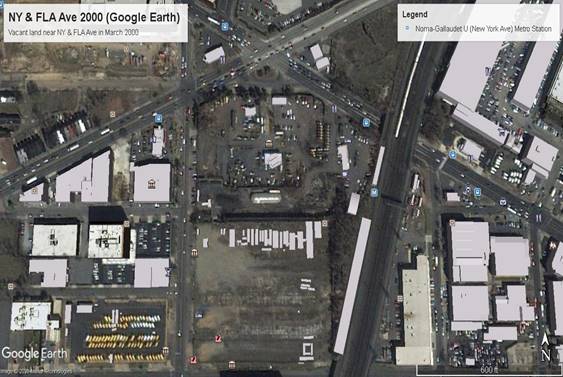
Source: Google Earth
Development-Oriented Transit
- The aerial photo on the right is from 2000. Owners of vacant land wanted to develop office buildings. But permits were denied because the only access was via over- crowded arterial streets.
- Landowners petitioned the District Government to construct a transit station nearby to facilitate development.*
- The District Government was in receivership and refused to proceed unless the landowners contributed significantly to the project.
- Landowners offered $25 million (about 1/3 of the estimated initial cost). The District Government issued a $25 million bond. The nearby landowners are paying it off over 20 years through a special assessment that was enacted with their support. (Pre-existing residential properties were exempted.)
Development-Oriented Transit (continued)
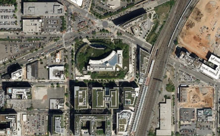
- The aerial photo on the right is from 2019. The new transit station is near the center on the left side of the tracks.
- New street segments to the east and south of the new Bureau of Alcohol Tobacco & Firearms were paid for by the adjacent landowners because they primarily provide access to those properties.
- As of 2021, most of the vacant land in this photo near the new transit station has been developed. Old warehouses (east of the tracks) are being redeveloped.
- Special assessment payments, based on land value, encourage development.
- For more info, see NoMa-Gallaudet U Metro Station: Success Built on Transit by ULI Washington.
« Previous


