U.S. Department of Transportation
Federal Highway Administration
1200 New Jersey Avenue, SE
Washington, DC 20590
202-366-4000
Traffic data is critical in ensuring highway safety. Traffic data enables the identification of congestion and conflict zones, certain travel behavior (e.g., speeding), and hot spot or zonal safety analysis.
MIRE provides a national model and standardized framework for collecting and managing roadway and traffic data.
MIRE offers a comprehensive listing of roadway and traffic elements with a data dictionary and linkages to other Federal datasets, supporting state and local agencies to use their own data for analysis instead of default values, improving safety evaluations and supporting data-driven investment decisions. Below lists the standard traffic data items called for by MIRE. MIRE Fundamental Data Elements (FDEs) are denoted by an asterisks "*".
Roadway Segment
Route Number*, Route/Street Name*, Begin Point Segment Descriptor*, End Point Segment Descriptor*, Type of Governmental Ownership*, Segment Identifier, Segment Length*, Direction of Inventory, Functional Class*, Rural/Urban Designation*, Federal-Aid, Route Type*, Access Control*, Surface Type*, Number of Through Lanes*, Median Type, Annual Average Daily Traffic (AADT)*, AADT Year*, One/Two-Way Operations*, County Name, County Code, Highway District, Specific Governmental Ownership, City/Local Jurisdiction Name, City/Local Jurisdiction Urban Code, Route Signing, Route Signing Qualifier, Coinciding Route Indicator, Coinciding Route - Minor Route Information, Total Paved Surface Width, Surface Friction, Surface Friction Date, International Roughness Index (IRI), International Roughness Index (IRI) Date, Pavement Condition (Present Serviceability Rating [PSR]), Pavement Condition (PSR) Date, Outside Through Lane Width, Inside Through Lane Width, Cross Slope, Auxiliary Lane Presence/Type, Auxiliary Lane Length, Managed Lane Operations Type, Managed Lanes, Reversible Lanes, Presence/Type of Bicycle Facility, Width of Bicycle Facility, Number of Peak Period Through Lanes, Right Shoulder Type, Right Shoulder Total Width, Right Paved Shoulder Width, Right Shoulder Rumble Strip Presence/Type, Left Shoulder Type, Left Shoulder Total Width, Left Paved Shoulder Width, Left Shoulder Rumble Strip Presence/Type, Sidewalk Presence, Curb Presence, Curb Type, Median Width, Median Barrier Presence/Type, Median (Inner) Paved Shoulder Width, Median Shoulder Rumble Strip Presence/Type, Median Sideslope, Median Sideslope Width, Median Crossover/Left-Turn Lane Type, Roadside Clear Zone Width, Right Sideslope, Right Sideslope Width, Left Sideslope, Left Sideslope Width, Roadside Rating, Tapered Edge, Major Commercial Driveway Count, Minor Commercial Driveway Count, Major Residential Driveway Count, Minor Residential Driveway Count, Major Industrial/Institutional Driveway Count, Minor Industrial/Institutional Driveway Count, Other Driveway Count, Terrain Type, AADT Annual Escalation Percentage, Percent Single Unit Trucks or Single Truck AADT, Percent Combination Trucks or Combination Truck AADT, Percentage Trucks or Truck AADT, Total Daily Two-Way Pedestrian Count/Exposure, Bicycle Count/Exposure, Motorcycle Count or Percentage, Hourly Traffic Volumes (or Peak and Off peak AADT), K-Factor, Design Hour Directional Factor, Speed Limit, Truck Speed Limit, Nighttime Speed Limit, 85th Percentile Speed, Mean Speed, School Zone Indicator, On-Street Parking Presence, On-Street Parking Type, Roadway Lighting, Toll Charged, Toll Type, Edgeline Presence/Width, Centerline Presence/Width, Centerline Rumble Strip Presence/Type, Passing Zone Percentage, Bridge Numbers for Bridges in Segment.
At-Grade Intersection or Junction
Unique Junction Identifier*, Location Identifier for Road 1 Crossing Point*, Location Identifier for Road 2 Crossing Point*, Intersection/Junction Geometry*, Intersection/Junction Traffic Control*, Type of Intersection/Junction, Location Identifier for Additional Road Crossing Points, Intersection/Junction Number of Legs, School Zone Indicator, Railroad Crossing Number, Intersecting Angle, Intersection/Junction Offset Distance, Signalization Presence/Type, Intersection/Junction Lighting, Circular Intersection - Number of Circulatory Lanes, Circular Intersection - Circulatory Lane Width, Circular Intersection - Inscribed Diameter, Circular Intersection - Bicycle Facility, Unique Approach Identifier*, Intersection Identifier for this Approach, Approach AADT, Approach AADT Year, Approach Mode, Approach Directional Flow, Number of Approach Through Lanes, Left-Turn Lane Type, Number of Exclusive Left-Turn Lanes, Length of Exclusive Left-Turn Lanes, Amount of Left-Turn Lane Offset, Right-Turn Channelization, Traffic Control of Exclusive Right-Turn Lanes, Number of Exclusive Right-Turn Lanes, Length of Exclusive Right-Turn Lanes, Approach Median Type, Approach Traffic Control, Approach Left-Turn Protection, Signal Progression, Crosswalk Presence/Type, Pedestrian Signal Activation Type, Pedestrian Signal Presence/Type, Crossing Pedestrian Count/Exposure, Left/Right-Turn Prohibitions, Right-Turn-On-Red Prohibitions, Left-Turn Counts/Percent, Year of Left-Turn Counts/Percent, Right-Turn Counts/Percent, Year of Right-Turn Counts/Percent, Transverse Rumble Strip Presence, Circular Intersection - Entry Width, Circular Intersection - Number of Entry Lanes, Circular Intersection - Presence/Type of Exclusive Right-Turn Lane, Circular Intersection - Exit Width, Circular Intersection - Number of Exit Lanes, Circular Intersection - Exit Radius, Circular Intersection - Pedestrian Facility, Circular Intersection - Crosswalk Location, Circular Intersection - Island Width, Circular Intersection - Entry Radius.
Interchange/Ramp
Unique Interchange Identifier*, Interchange Type*, Ramp Length*, Ramp AADT*, Year of Ramp AADT*, Roadway Type at Beginning Ramp Terminal*, Location Identifier for Roadway at Beginning Ramp Terminal*, Roadway Type at Ending Ramp Terminal*, Location Identifier for Roadway at Ending Ramp Terminal*, Interchange Location Identifier for Road 1 Crossing Point, Interchange Location Identifier for Road 2 Crossing Point, Interchange Location Identifier for Additional Road Crossing Points, Interchange Lighting, Interchange Entering Volume, Interchange Identifier for this Ramp, Unique Ramp Identifier, Ramp Acceleration Lane Length, Ramp Deceleration Lane Length, Ramp Number of Lanes, Ramp Metering, Ramp Advisory Speed Limit, Roadway Feature at Beginning Ramp Terminal, Location of Beginning Ramp Terminal Relative to Mainline Flow, Roadway Feature at Ending Ramp Terminal, Location of Ending Ramp Terminal Relative to Mainline Flow.
Highway safety exposure data measures how often people, vehicles, or travel are exposed to the risk of crashes on the road network. It quantifies opportunities for crashes to occur and serves as the denominator used to interpret crash counts and calculate meaningful safety rates and risks. The specific traffic data needed are:
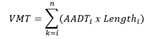
VMT
Cumulative vehicle miles traveled for a given area, a given function class of roadway way, or any roadway, timing and date groupings.
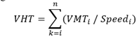
VHT
Cumulative vehicle hours traveled for a given area, a given function class of roadway way, or any roadway, timing and date groupings.
AADT or Other Flow Data
AADTs associated with individual links can be used as the denominator to normalize crashes or incidents.
Vehicle crash causation analysis is the systematic process of identifying factors and the sequence of events that result in crashes. From a traffic standpoint, the data listed below are typically gathered.





